
 Official 7-Day Cyclone Forecast & Outlook for Australia
Never miss a severe weather warning
Instant push, email & SMS alerts for your location — aggregated from BOM, JTWC, Geoscience Australia, USGS and AFAC/state fire agencies, matched with PostGIS spatial queries.
This is the official 7-day cyclone forecast and outlook for Australia, powered by ECMWF ensemble probability maps. Use the interactive maps below to track tropical low and tropical cyclone genesis chances across the Coral Sea, Timor Sea, Gulf of Carpentaria and eastern Indian Ocean during the 2026/2027 cyclone season — updated twice daily at 00:00 UTC and 12:00 UTC.
Cyclone outlook vs cyclone forecast: what is the difference?
Australians searching for a cyclone forecast and a cyclone outlook are usually after two related but distinct products. Both are answered on this page — the maps above show the 7-day forecast, while the seasonal context below explains the outlook.
7-day cyclone forecast
Short-range probabilistic guidance on where a tropical low or tropical cyclone is most likely to form in the next 1–7 days. Sourced from the ECMWF ensemble (51 members) and refreshed twice daily. Best used for operational decisions in the coming week.
Seasonal cyclone outlook
Longer-range guidance on how active the entire November–April Australian cyclone season is likely to be, driven by climate drivers such as ENSO, the IOD and the MJO. Best used for preparedness, insurance and planning months ahead.
Tropical Depression Genesis Probability
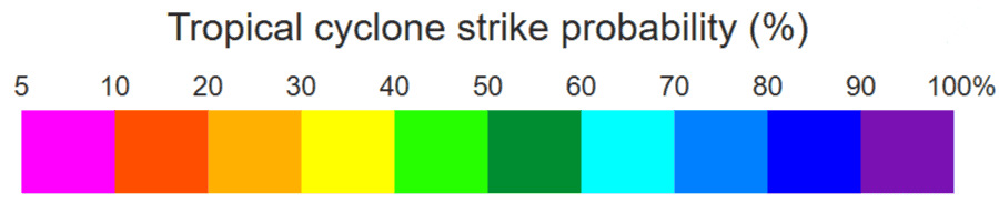
This map displays ECMWF ensemble prediction probabilities for tropical depression (tropical low) formation across Australian waters. Tropical depressions are organized low-pressure systems with sustained winds below 63 km/h (34 knots) that may intensify into tropical cyclones under favorable conditions.
Higher probability percentages (warm colors) indicate increased confidence in tropical low development within the forecast period. These systems commonly form in the monsoon trough across northern Australia, particularly in the Coral Sea, Gulf of Carpentaria, Timor Sea, and waters northwest of Western Australia during the November-April cyclone season.
Understanding Tropical Cyclone Probability Forecasts
How ECMWF Ensemble Predictions Work
The European Centre for Medium-Range Weather Forecasts employs ensemble prediction systems (EPS) that run 50+ slightly varied forecast scenarios simultaneously. Each ensemble member uses perturbed initial conditions and model physics to represent forecast uncertainty. Tropical cyclone genesis probability is calculated by determining what percentage of ensemble members predict cyclone formation in specific geographic regions.
For example, if 30 out of 51 ensemble members predict tropical cyclone formation in the Coral Sea within 7 days, the displayed probability would be approximately 59% (30/51). Higher ensemble agreement produces higher probabilities, indicating greater forecast confidence in cyclogenesis events.
Interpreting Probability Thresholds
- Low Probability (0-20%): Minimal ensemble agreement on cyclone formation; background climatological risk during cyclone season
- Moderate Probability (20-40%): Some ensemble members indicate potential development; monitor conditions closely
- Elevated Probability (40-60%): Significant ensemble agreement suggesting favorable cyclogenesis conditions; increased vigilance warranted
- High Probability (60-80%): Strong ensemble consensus on tropical cyclone formation; prepare for potential cyclone impacts
- Very High Probability (80%+): Exceptional ensemble agreement; cyclone formation highly likely; follow official warnings
Australia's Primary Cyclone Formation Regions
Northern Australian waters experience tropical cyclone formation in several key regions during the November-April season:
- Coral Sea: Between the Queensland coast and Vanuatu; most active Australian cyclone genesis region with warm SSTs
- Timor Sea & Arafura Sea: Waters north of Northern Territory; monsoon trough commonly generates cyclones here
- Gulf of Carpentaria: Enclosed tropical waters between Queensland and Northern Territory; can rapidly intensify cyclones
- Northwest Coast (WA): From Exmouth to Broome; Indian Ocean cyclones frequently impact the Pilbara region
- Torres Strait: Waters between Queensland's Cape York and Papua New Guinea; transitional cyclone formation area
Australian Tropical Cyclone Season Outlook 2026/2027
The Australian tropical cyclone season spans November 1 to April 30, with peak activity typically occurring January through March. The 2026/2027 season's cyclone activity will be influenced by large-scale climate drivers including El Niño-Southern Oscillation (ENSO), Indian Ocean Dipole (IOD), and Madden-Julian Oscillation (MJO) phases.
ECMWF tropical cyclone genesis probability forecasts provide medium-range (7-10 day) guidance on formation likelihood for the 2026/2027 season, helping Australian communities, emergency services, and industries prepare for potential cyclone impacts. These probabilistic forecasts complement deterministic track predictions issued once cyclones develop.
Key Forecast Periods to Monitor
- November-December: Early season activity as monsoon develops; typically lower cyclone frequency
- January-February: Peak cyclone season with highest formation probability and intensity potential
- March-April: Late season activity as monsoon retreats; continued risk particularly in Coral Sea
How to Use These Tropical Cyclone Forecasts
For General Public: Check probability maps regularly during cyclone season, especially before coastal travel or maritime activities. Elevated probabilities (above 40%) warrant increased awareness of developing weather systems. Always follow official warnings from Australian authorities when cyclones threaten.
For Emergency Management: Use extended forecasts for resource pre-positioning and readiness planning. Probability trends can indicate periods requiring heightened preparedness across cyclone-prone regions. Integrate ECMWF guidance with Bureau of Meteorology warnings for comprehensive situational awareness.
For Maritime Operations: Monitor genesis probability maps before voyage planning in northern Australian waters. Avoid operating in areas showing elevated cyclone formation probabilities. Coordinate forecast information with official maritime warnings and vessel routing services.
For Agriculture & Industry: Extended forecasts support seasonal planning for cyclone-sensitive operations. Pre-season probability outlooks help inform decisions on infrastructure protection, crop planning, and insurance considerations in tropical regions.
Important Forecast Guidance
These ECMWF probability forecasts provide valuable guidance on potential tropical cyclone formation but should not be used as sole decision-making tools for life-safety decisions. Always follow official tropical cyclone warnings, watches, and advisories issued by Australian meteorological authorities. Forecast uncertainty increases with lead time. For active cyclone tracking, wind warnings, and evacuation orders, consult official government sources.
Understanding Tropical Low Formation
Tropical lows are areas of low pressure in tropical regions with organized convection but wind speeds below cyclone thresholds. These systems form over warm ocean waters and may intensify into tropical cyclones under favorable atmospheric conditions including low wind shear and high sea surface temperatures.
ECMWF Ensemble Forecasting
The European Centre for Medium-Range Weather Forecasts uses ensemble prediction systems that run multiple forecast scenarios to quantify uncertainty. Tropical cyclone genesis probabilities are derived from analyzing how many ensemble members predict cyclone formation in specific regions, providing probabilistic rather than deterministic guidance.
Key Cyclone Formation Factors
Tropical cyclone formation requires sea surface temperatures above 26.5°C, low vertical wind shear, sufficient atmospheric moisture, pre-existing disturbance or tropical low, and location at least 5° latitude from the equator. Australian waters meet these criteria during the November-April cyclone season, particularly in the Coral Sea and Timor Sea.