2026/27 Australian Cyclone Season Outlook
How many cyclones to expect, where they're most likely, and what a record El Niño means for the wet season.
Cyclone season outlook summary
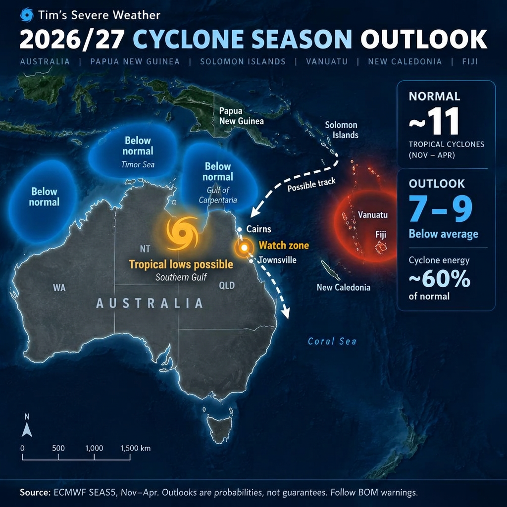
The 2026/27 cyclone season in Australia is shaping up quieter than normal. With a strong El Niño in place, we estimate 7 to 9 tropical cyclones in the Australian region, compared with about 11 in a typical year, and only around 60% of the usual cyclone energy. Activity is likely to sit further east, near Vanuatu and Fiji.
Cyclone season Australia 2026/27 at a glance
Here is how this season compares with a normal Australian cyclone season.
| Measure | Normal season | 2026/27 outlook |
|---|---|---|
| Tropical cyclones (Australian region) | About 11 (long-term) / 9 (since 2000) | 7–9 (our estimate) |
| Cyclone energy (ACE) | 100% | About 60% of normal |
| Main driver | Neutral ENSO | Strong El Niño |
| Monsoon onset (Darwin) | Late December | Likely mid to late January |
| Most active area | Coral Sea, NW shelf, Gulf | Vanuatu and Fiji (further east) |
The 7–9 figure is our estimate based on reduced cyclone energy in seasonal model guidance. The seasonal charts don't give an official cyclone count.
What El Niño means for the cyclone outlook
El Niño happens when the central and eastern Pacific Ocean becomes much warmer than normal. In mid-October 2026, the Bureau of Meteorology's weekly Niño 3.4 reading was about +2.8 °C, which puts this among the strongest El Niño events on record.
During El Niño, the warmest water and the rising air that feeds storms move east, away from Australia. That usually means fewer cyclones near our coast and more near Pacific islands. Learn more in our El Niño and La Niña guide.
Where cyclones are most and least likely
- Quieter than normal: off Western Australia, the Timor Sea and the Gulf of Carpentaria.
- Most active: the south-west Pacific near Vanuatu and Fiji, further east than usual.
- Watch area: the southern Gulf of Carpentaria, where significant tropical lows could still form and bring heavy rain.
A possible Coral Sea and east coast track
One scenario to watch is a system forming near the Solomon Islands or Vanuatu, moving towards north-east Queensland and then down the east coast. This is possible, not expected, but late-season systems in El Niño years have done this before. Follow any developing system on our current active cyclones page, or see past paths in the historical cyclone archive.
2026/27 wet season outlook for northern Australia
The monsoon is likely to arrive late, possibly mid to late January rather than late December. The tropics rely heavily on large global drivers like El Niño, so northern Australia could see one of its drier wet seasons on record.
See how the monsoon works in our Australian monsoon guide, and check the 3-month Australia seasonal forecast.
Warmer oceans in the south: an unusual twist
In most El Niño years the seas around southern and eastern Australia are cooler, which helps reduce rain. This season they are warmer than normal. Warm water adds moisture to the air, so the south and east may not dry out as much as a typical El Niño would suggest. Explore the latest sea surface temperature anomaly charts and the daily rainfall forecast.
Prepare now, even in a quiet season
A below-average season still only takes one cyclone to cause serious damage. Get your emergency kit and plan ready before December, and keep an eye on the ECMWF seasonal cyclone forecast and our live wet season driver outlook as the season develops.
Read the cyclone preparedness guideDisclaimer: this outlook is a forecast estimate based on seasonal model guidance from the Bureau of Meteorology, ECMWF and NOAA. It is not an official warning. Always follow the Bureau of Meteorology for official cyclone advice.
Frequently Asked Questions
Related Resources
- Live Cyclone & Wet Season Outlook (driver data)
- Tropical Cyclones Hub
- Current Active Cyclones
- Cyclone Warnings — BOM Advisories
- Cyclone Tracker & Forecast Maps
- Seasonal Cyclone Forecast (ECMWF)
- Australia Seasonal Weather Forecast
- Cyclone Preparedness Guide
- Historical Cyclone Archive
- El Niño & La Niña Guide
- Australian Monsoon Guide
- Daily Rainfall Forecast
- 7 Day Rainfall Forecast