
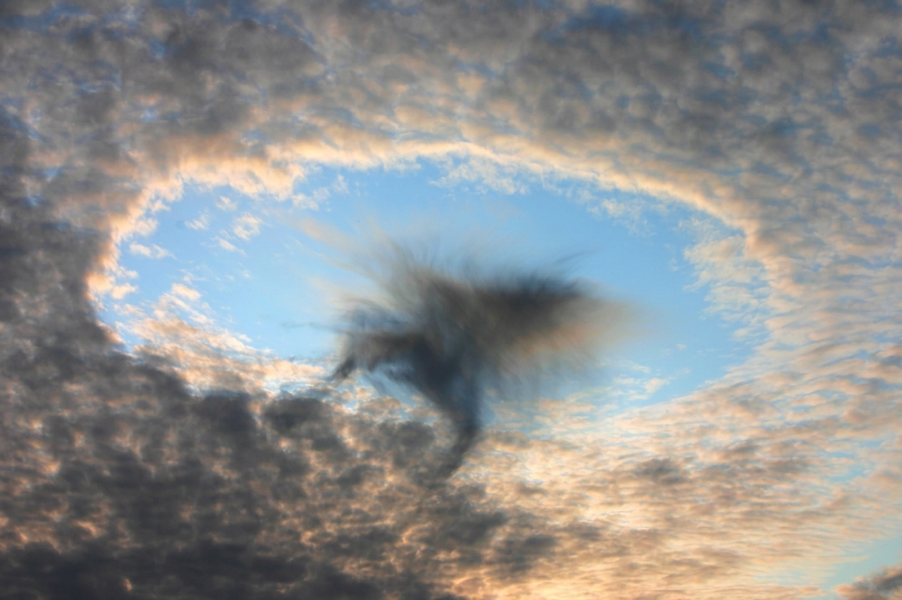
A fallstreak hole is a rare circular gap that forms in a cloud layer when supercooled water droplets freeze into ice crystals. As those ice crystals grow and fall, they leave a clear opening that can look like a hole punched through the sky.
Key takeaways
- Fallstreak holes, also called hole punch clouds or cavum, usually appear in mid-level cloud layers such as altostratus clouds and cirrocumulus clouds.
- In Victoria, one well-known example of a punch hole cloud drew significant public attention that required official explanation.
- An aircraft is often the trigger, although other disturbances can also set the process in motion.
- The falling streaks below the gap are called fallstreaks or virga.
- Fallstreak holes look dramatic, but they are usually harmless to people on the ground.
What causes a fallstreak hole in the sky?
A fallstreak hole, sometimes called a punch hole cloud, forms when a cloud contains liquid water droplets that are colder than freezing. If the droplets are disturbed, they can freeze quickly and form ice crystals. As the ice crystals grow, they draw moisture from nearby droplets and leave a round or oval gap in the cloud. The result is a striking hole in the sky cloud that may grow wider as the cloud layer drifts along.
The Science Behind Cavum: Formation Explained
The Bureau of Meteorology (BOM) and meteorologists use cavum as the formal name for this sky phenomenon. Many people still call it a fallstreak cloud, hole punch cloud, or cloud hole phenomenon. The basic process depends on three things: a suitable cloud layer, supercooled water droplets, and a trigger that starts ice formation.

Cavum is most often associated with altocumulus and cirrocumulus clouds, and it can also occur in altostratus, stratocumulus, and some other cloud layers. These clouds can contain liquid droplets even when the air temperature is below 0°C. That liquid water is said to be supercooled. It stays liquid until something disturbs the cloud enough for freezing to begin.
Once ice crystals form, they grow by taking water vapour from the surrounding droplets. The droplets shrink or evaporate, while the ice crystals become heavier. That is why a narrow trail of falling ice often appears below the hole. Meteorologists call those trails fallstreaks or virga.
This process is often linked with the Bergeron-Findeisen process, which describes how ice and liquid water interact inside mixed-phase clouds. In plain terms, once ice gets a head start, it can grow at the expense of nearby liquid droplets. That is why a small disturbance can create such a large opening in a cloud layer.
In many cases, the hole forms as a smooth-edged opening with a bright, icy centre nearby and a lower curtain of streaks beneath it. The exact shape depends on the depth of the cloud, wind at cloud level, and how much moisture is available. Some cavum clouds are neat and round, while others look stretched or ragged.
How Aircraft Trigger This Cloud Hole Phenomenon
Aircraft are one of the most common triggers for a fallstreak hole. When an aeroplane flies through a cloud layer containing supercooled water droplets, air moving around the wings and other surfaces can cause brief cooling and pressure changes. That can be enough to start ice formation in the cloud.
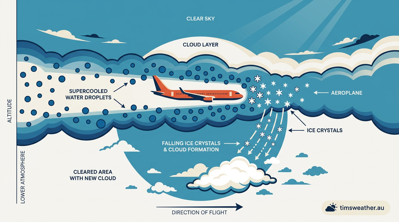
As the aircraft passes through, it leaves behind a narrow region where conditions have changed just enough for droplets to freeze. Once the first ice crystals form, they can spread the effect through a larger patch of cloud. The opening then widens as the cloud drifts and the ice crystals continue to grow.
This is why fallstreak holes are often seen near flight paths. The aircraft itself does not carve a physical hole through the cloud. Instead, it acts as the trigger that starts a chain reaction inside a supercooled layer. The result can be a neat circular gap that seems to appear almost all at once.
The same basic idea can occur after other small disturbances, such as a change in airflow or a passing wave through the cloud. Even so, aircraft remain the trigger most people notice because the timing lines up so clearly with the visible hole.
Fallstreak Holes and Aviation Safety
A fallstreak hole can look alarming, but the cloud itself is not a sign of danger at the surface. For people on the ground, the phenomenon is usually harmless. It does not mean the sky is about to open or that severe weather is on the way.

For aviation, the picture is different. Supercooled water droplets are a known icing hazard because they can freeze on aircraft surfaces. That is why pilots, dispatchers, and weather forecasters pay close attention to cloud layers where icing may occur. The visible hole is not the hazard. The presence of supercooled water droplets is the real concern.
BOM forecasts and aviation weather products help identify cloud layers that may contain supercooled liquid water. That information matters for flight planning, especially in colder months and in cloud bands where icing risk is more likely. A fallstreak hole may be a useful visual clue that those conditions were present.
Even so, the cavum itself usually causes no heavy rain, no severe turbulence, and no direct threat to people watching from below. It is best thought of as a sign that the cloud has briefly changed phase, not as a storm warning.
Common Misconceptions About Hole-Punch Clouds
Because the gap looks so unusual, people often mistake a fallstreak hole for something man-made or something far more unusual than it is. In reality, it is a natural cloud feature. The shape can appear almost perfect, which is part of why it attracts so much attention.
Some observers assume the cloud has been physically blown apart. That is not what happens. The cloud water does not vanish. Instead, the droplets change into ice crystals, and those crystals fall out of the main layer while leaving a visible opening behind.
Another common misunderstanding is that a fallstreak hole means the weather is becoming severe. That is not usually true. The cloud may be cold and contain supercooled water droplets, but the hole itself is not a warning of thunder, hail, or strong wind at the ground.
One well-known Australian example came from Victoria, where a large cavum drew public attention after many people saw the unusual shape overhead. The Bureau of Meteorology (BOM) explained that the display was a classic fallstreak hole rather than anything mysterious. That kind of public response is common because the feature is so visually striking.
Comparing Rare Cloud Formations Explained
It helps to compare a fallstreak hole with other unusual cloud types. Some are created by ice, some by wind, and some by air rising over terrain. They can all look unusual, but the cause is different in each case.
| Cloud Type | Appearance | How it forms | Where it is often seen |
|---|---|---|---|
| Fallstreak hole | Circular gap with streaks below | Supercooled droplets freeze into ice crystals | Mid-level cloud layers, often near aircraft routes |
| Mammatus Clouds | Pouch-like lobes under a cloud base | Sinking air and evaporative cooling | Often beneath thunderstorm anvils |
| Kelvin-Helmholtz | Wave-like curls or breaking crests | Wind shear between air layers | Where strong wind differences exist |
| Lenticular clouds | Smooth lens or saucer shapes | Moist air rises over mountains | Downwind of ranges and high terrain |
How to photograph a fallstreak hole in Australia
If you want to photograph a fallstreak hole, timing matters. These clouds are short-lived, so the best chance is to be outside when mid-level cloud layers are drifting overhead. Areas near major airports may see them more often because aircraft can act as the trigger.

Look for patches of altostratus clouds or cirrocumulus clouds with a sudden round opening and bright streaks beneath it. A wide-angle lens can help capture the full shape of the cloud. It also helps to take a few frames quickly, since the hole can change shape as the cloud moves.
For Australian sky watchers, BOM forecasts can help you spot days with the right cloud layers. A cool, moist day with high cloud and light winds may be a better bet than a clear blue sky. Still, there is no guarantee. Fallstreaks are rare, and the right conditions have to line up at the right time.
Some photographers share sightings through local weather groups and cloud-watching communities. Those images help meteorologists and enthusiasts track where cavum has appeared and how it has changed. They also give a useful record of how the cloud evolved from a narrow opening into a wider hole.
Why meteorologists pay attention to cavum
Meteorologists study cavum because it offers a clear sign that supercooled water droplets were present in the cloud layer. That makes it useful for understanding cloud physics, icing conditions, and the way ice crystals grow inside mixed-phase clouds. It is a small feature, but it reveals a lot about the air above us.
In atmospheric science, features like the fallstreak hole help connect visible cloud behaviour with the processes happening inside the cloud. The opening is not just a curiosity. It shows how sensitive cloud water can be to small changes in temperature and motion.
For students of weather, it is also a useful reminder that not every unusual sight in the sky signals danger. Some sky phenomena are simply the visible result of water changing phase, wind moving through a cloud, or an aircraft passing through a cold layer. Cavum is one of the clearest examples.
Frequently asked questions
A fallstreak hole is a gap that forms in a layer of supercooled cloud when ice crystals rapidly grow and fall out, leaving a clear hole. It's also known as a hole-punch cloud or cavum. These striking meteorological phenomena provide a fascinating insight into atmospheric processes.
Source: science.nasa.gov
Further reading and resources
Explore trusted articles, books, videos and other resources to go deeper on this topic.
tnc.networkArticle
WHAT ARE HOLE PUNCH CLOUDS? - TNC Network, LLC
This article provides another authoritative explanation of cavum, its nicknames, and formation.
sciencenotes.orgReference
Weather Glossary - Meteorology Terms and Definitions
Offers a concise definition of fallstreak holes within a broader meteorological context.
www.youtube.comVideo
RARE CLOUD PHENOMENA: Nature's Strangest Sky Formations ...
A short video showcasing fallstreak holes alongside other rare cloud phenomena.
grokipedia.comArticle
Fallstreak hole — Grokipedia
Provides a comprehensive overview of fallstreak holes, including structural descriptions and common names.
www.kickassfacts.comArticle
25 Awesome Natural Phenomenon | KickassFacts
Lists fallstreak holes as one of many fascinating natural phenomena, providing a brief explanation.
Bubbles in the SKY !!! Strange Phenomenon Mammatus Clouds ...
... fallstreak hole, hole punch cloud, beautiful clouds, weather questions, weather phenomena, severe events, landscape, clouds formation, best, top 10 ...
ja.wikipedia.orgReference
穴あき雲 - Wikipedia
穴あき雲 ... 穴空き雲(あなあきぐも)とは、層状に薄く広がった巻積雲や高積雲でみられる、円形の隙間が空いた雲である。英語では "fallstreak hole"、"hole punch cloud"、" ...
wildcardweather.comArticle
Sun Dog INSIDE a Hole Punch Cloud - wildcard weather
... fallstreak hole (hole punch cloud). Similar to a rainbow but closer to halos you see around the moon. Hole Punch Cloud: Also known as a ...
cloudatlas.wmo.intReference
cloudatlas.wmo.int
Insane cloud formation! - YouTube
Have u heard of the term Fallsstreak hole? Or Pareidolia? A fallstreak hole, hole punch cloud, punch hole cloud, skypunch, cavum cloud canal ...
Planning weeks ahead?
Check Australia's long-range seasonal outlook for rainfall, temperature and the climate drivers (ENSO, IOD, SAM, MJO) shaping the next three months.
View Australia's Seasonal Weather Forecast