

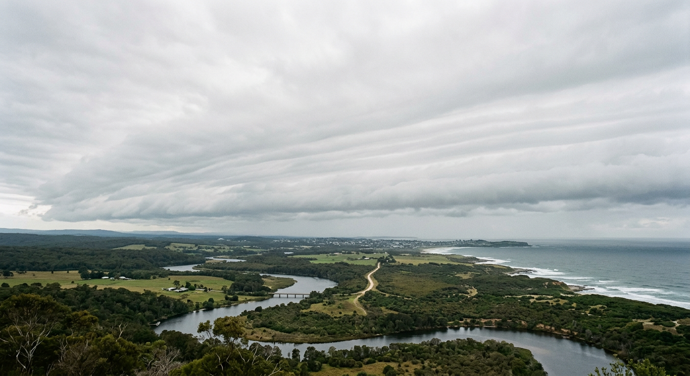
When asking how do stratus clouds form, the short answer is that these low-level clouds develop when moist air cools to its dew point through gentle lifting or horizontal movement over a cooler surface. In a stable atmosphere, that cooling is slow and widespread, so the cloud spreads into a flat grey layer with a low cloud base altitude, often below 2,000 metres.
Key takeaways
- A typical cloud droplet is about 20 micrometres in diameter, highlighting the microscopic scale of stratiform cloud development.
- Atmospheric stability helps keep the cloud layer flat and widespread.
- Temperature inversions can trap moisture in the boundary layer and help stratus persist.
- Stratus usually brings light drizzle, mist or a dull overcast sky, not heavy showers.
How do stratus clouds form?
Stratus clouds form when moist air becomes saturated near the surface or just above it. The air may cool from below, rise a little and expand, or move horizontally over a cooler surface. The main cloud types in Australia guide places stratus in the low cloud group, and that fits the look as well as the weather it brings, a broad, grey layer with little vertical growth.
The key idea is simple. Stratus needs a stable setup. If the air keeps rising in strong columns, the cloud can grow into cumulus or thunderstorms. If the air stays layered, the cloud spreads sideways instead. That is why stratus often hangs around for hours, especially when the lower atmosphere is moist and calm.
What does low-level cloud formation mean?
Low-level cloud formation refers to cloud development in the lower part of the troposphere, where temperature, moisture and wind close to the ground do most of the work. Stratus is one of the clearest examples of this. It usually forms in the boundary layer, the thin slice of air closest to the surface that responds quickly to heating, cooling and changes in wind.
Because this layer is shallow, small shifts in temperature and humidity can matter a lot. A slight drop in temperature, or a nudge of moist air over cooler ground or water, may be enough to bring the air to saturation. Once that happens, tiny droplets form on condensation nuclei such as dust, salt or smoke particles.
Why does atmospheric stability matter?
Atmospheric stability is a major reason stratus clouds keep their flat shape. Stable air resists vertical motion, so parcels of air do not keep rising after they cool. Instead of building tall clouds, the air spreads out in a thin sheet. That is why stratus often looks uniform, with a dull grey underside and little texture.
This is also why stratus is common under light wind conditions or beneath a lid of warmer air aloft. When the atmosphere is stable, the boundary layer cannot mix freely. Moisture stays trapped near the surface, and the cloud base altitude remains low.
The science of stratiform cloud development
Stratus is a stratiform cloud, which means it forms in layers rather than in towers. The process starts with water vapour in the air. As the air cools to its dew point, the vapour condenses into tiny droplets. Those droplets are small enough to stay suspended. A typical cloud droplet is about 20 micrometres in diameter, according to www.snexplores.org.
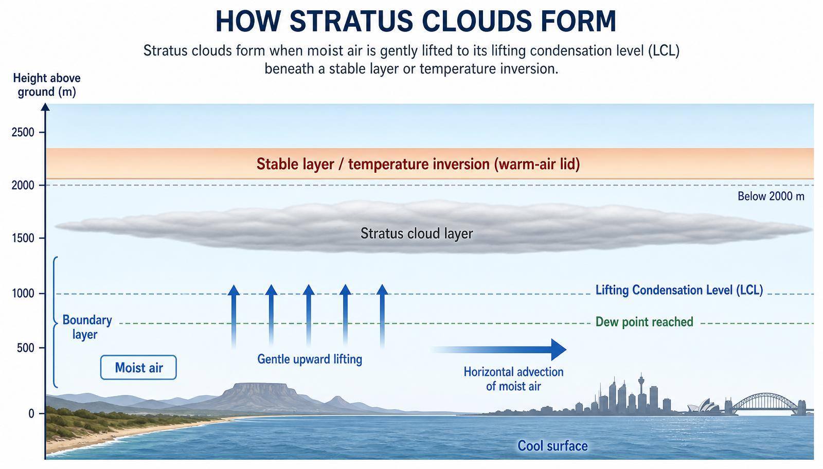
One way to picture this is to think about the lifting condensation level, or LCL. The LCL is the height where a rising parcel of air becomes saturated. Below that level, the air can hold its moisture as vapour. At the LCL, condensation starts and a cloud base can form. If the air above that level is stable, the cloud stays thin and layered rather than growing upward.
Adiabatic cooling explained
Adiabatic cooling happens when air rises and expands because the surrounding pressure is lower. Expansion uses energy, so the parcel cools. That cooling can bring the air to its dew point even if the ground itself is not very cold. Gentle lift from hills, weak fronts or shallow coastal flow can be enough for stratus to form.
This is a useful idea for readers because it explains why cloud can form without strong storms. The air does not need to rocket upward. It only needs to rise a little, cool enough, and reach saturation in a stable layer.
What role do condensation nuclei play?
Condensation nuclei give water vapour a surface to cling to. Without them, cloud droplets would struggle to form quickly. In the real atmosphere, these tiny particles are everywhere, especially near coasts, where sea salt adds plenty of nuclei. That is one reason marine air often turns cloudy so readily.
Once droplets begin to form, they can grow by adding more water vapour or by colliding with nearby droplets. In stratus, that growth is usually modest. The cloud remains full of very small droplets, which is why it often looks smooth and can produce mist or drizzle rather than heavy rain.
The Role of Temperature Inversions in Australian Stratus Development
Temperature inversions are one of the clearest reasons stratus can linger along the Australian coast. In a normal profile, air gets cooler with height. In an inversion, a warmer layer sits above cooler air near the ground. That warmer layer acts like a lid and limits vertical mixing in the boundary layer.
The Bureau of Meteorology, or BOM, often refers to these setups in forecast discussions and aviation products when low cloud or poor visibility is expected. In practical terms, the inversion traps moisture close to the surface. Overnight cooling, moist onshore flow or leftover damp air from the previous day can then push the layer to saturation.
Once the cloud forms, the inversion helps keep it there. The lid above the cloud stops the air from mixing upward, so the stratus layer stays flat. If daytime heating is weak, the cloud may hold through the morning or even longer.
How temperature inversions affect the cloud base altitude
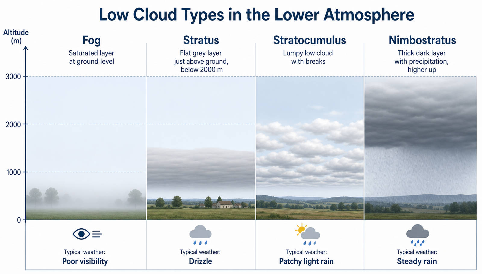
A strong inversion often keeps the cloud base altitude low because the saturated layer is shallow. That means the cloud deck may sit just above the ground, or rise and fall a little as winds and moisture change. If the cloud base reaches the surface, the same setup is called fog rather than stratus.
This is where the line between cloud and fog becomes useful. The physics is much the same. The difference is where the saturated layer sits. Above the ground, it is stratus. At ground level, it is fog.
Advection Stratus: Cold Coastal Waters and Moist Air Interaction
Advection stratus forms when horizontal air movement carries moist air over a cooler surface. The air cools from below, reaches its dew point and condenses into a low cloud layer. This is a common coastal process and a good example of how advection fog and stratus are linked.
In Australian terms, this often matters near the sea, where marine air passes over cooler water or a cooler land surface. The marine layer is the moist, shallow layer of air sitting above the ocean. If that layer moves inland without much mixing, it can bring low cloud, mist and a grey morning sky to coastal suburbs.
This process does not need strong winds. In fact, gentle winds are often enough. The key is the sideways transport of moist air over a cooler surface, not towering uplift. That is why advection stratus can arrive quietly and spread widely.
What is the marine layer?
The marine layer is a cool, moist layer of air that develops over the ocean and coastal waters. It often sits beneath a temperature inversion, which keeps it shallow. When this layer moves over land, it can bring stratus, fog or low cloud depending on how much cooling and mixing occurs.
If the marine layer is deep and the air remains moist, the stratus can cover a large area. If the sun warms the land quickly, the cloud may lift or break apart after sunrise. That is why coastal mornings can start grey and end bright.
How advection and lifting differ
Stratus can form in more than one way, but the two main paths are gentle lifting and advection. Gentle lifting cools air as it rises. Advection cools air by moving it over a colder surface. Both routes can reach the lifting condensation level, and both can produce a layered cloud sheet if the atmosphere stays stable.
Here is the practical difference. Lifting is vertical motion. Advection is horizontal air movement. In the real atmosphere, they often work together, especially near coasts and low hills.
| Cloud type | Formation mechanism | Typical height | Common weather |
|---|---|---|---|
| Stratus | Gentle lifting or advection in stable air | Low cloud base altitude, often below 2,000 m | Mist, drizzle, dull overcast |
| Stratocumulus | Weak convection within a stable layer | Low to mid-level | Patchy light rain, broken cloud |
| Nimbostratus | Widespread frontal lifting | Thick layered cloud | Steady rain or drizzle |
| Fog | Saturated air at ground level | Surface layer | Very poor visibility |
How does stratus differ from fog?
Stratus and fog are closely related, and the difference comes down to height. The research bundle notes that fog occurs when the air is saturated with moisture at the surface. If that same saturated layer lifts a little, it becomes stratus. In both cases, the air has reached saturation and cloud droplets form on condensation nuclei.
For drivers and early commuters, that matters. If the cloud base sits on the ground, visibility can drop fast. If it sits just above the ground, the road may still be clear but low cloud can make the morning feel dim and damp.
Australian coastal patterns and BOM forecasting
Along the Australian coast, BOM forecasts often mention low cloud, patchy fog or poor visibility when the ingredients line up. Moist air, light winds, a cool surface and an inversion can all favour stratus. Coastal NSW and parts of Queensland often see these setups when overnight cooling is strong and the lower atmosphere stays moist.
The Great Dividing Range can also shape local cloud by slowing or lifting moist air moving inland from the Tasman Sea. That does not automatically create stratus, but it can help set up the gentle lifting needed for low cloud formation. Near the coast, the same air may also interact with cooler water, which supports advection stratus.
The main point is that stratus is usually a sign of a shallow, stable moisture layer. It is not a storm cloud. It is a layered cloud that tells you the lower atmosphere is cool, moist and not mixing much.
Do stratus clouds produce rain?
Stratus clouds can produce drizzle or very light rain, but they usually do not bring heavy falls. The droplets are small and the cloud is thin, so rainfall rates stay low. A related fact from www.snexplores.org is that raindrops can fall as fast as 10 metres per second, but stratus does not usually build the depth needed for frequent strong rain.
In Australia, that means stratus is more likely to bring a damp morning, mist on higher roads or a fine drizzle near the coast than a soaking rain band. If the cloud thickens into nimbostratus, the weather story changes, and steady rain becomes more likely.
How to read a stratus sky
Stratus clouds are plain to look at, but they still give useful clues. A smooth grey sheet usually points to stable air and a shallow moist layer. If the cloud is lifting and breaking by mid-morning, the sun is probably warming the surface enough to weaken the inversion. If it stays locked in place, the boundary layer may remain damp and cool all day.
Look for these signs:
- flat grey cloud with little texture
- low cloud base altitude
- mist or drizzle near the ground
- slow clearing after sunrise, or none at all
These signs help explain why stratus matters in daily forecasting. It can affect visibility, morning temperatures and how quickly the day warms up.
Related guides
Frequently asked questions
Stratus clouds form when moist, stable air is gently lifted or cooled from below until it reaches its saturation point. This process causes water vapour to condense into a low, uniform layer. These clouds typically develop in broad sheets and can produce light drizzle or fog-like conditions.
Source: bom.gov.au
Further reading and resources
Explore trusted articles, books, videos and other resources to go deeper on this topic.
en.wikipedia.orgReference
Stratus cloud
Background reference on How Do Stratus Clouds Form? The Science of Low-Level Cloud Layers from en.wikipedia.org.
scied.ucar.eduReference
Clouds and How They Form - UCAR Center for Science Education
Background reference on How Do Stratus Clouds Form? The Science of Low-Level Cloud Layers from scied.ucar.edu.
ebsco.comArticle
Clouds | Science | Research Starters
In-depth coverage on How Do Stratus Clouds Form? The Science of Low-Level Cloud Layers from ebsco.com.
weather.govReference
Cloud Classification
Background reference on How Do Stratus Clouds Form? The Science of Low-Level Cloud Layers from weather.gov.
study.comArticle
Stratus Clouds | Definition, Types & Facts - Video
In-depth coverage on How Do Stratus Clouds Form? The Science of Low-Level Cloud Layers from study.com.
weather.metoffice.gov.ukReference
Low level clouds
Background reference on How Do Stratus Clouds Form? The Science of Low-Level Cloud Layers from weather.metoffice.gov.uk.
noaa.govReference
Ten Basic Clouds | National Oceanic and Atmospheric Administration
Background reference on How Do Stratus Clouds Form? The Science of Low-Level Cloud Layers from noaa.gov.
Cloud
Background reference on How Do Stratus Clouds Form? The Science of Low-Level Cloud Layers from en.wikipedia.org.
The Four Core Types of Clouds
Background reference on How Do Stratus Clouds Form? The Science of Low-Level Cloud Layers from noaa.gov.
atmos.uw.eduReference
Stratus and Stratocumulus - Atmospheric Sciences
Background reference on How Do Stratus Clouds Form? The Science of Low-Level Cloud Layers from atmos.uw.edu.
Planning weeks ahead?
Check Australia's long-range seasonal outlook for rainfall, temperature and the climate drivers (ENSO, IOD, SAM, MJO) shaping the next three months.
View Australia's Seasonal Weather Forecast