

The Morning Glory cloud is a rare roll cloud that often appears as a long, tube-like band. This striking cloud formation is best known from Burketown and the Gulf of Carpentaria in Queensland, Australia, and is most often seen in the dry season, especially in September and October.
Key takeaways
- The Morning Glory cloud is a long roll cloud linked to an atmospheric solitary wave.
- A squall, a sudden temperature drop, and a sharp pressure change can occur on the ground as the atmospheric disturbance passes.
- The cloud can appear as a single band, or as twin sets moving across the sky.
- Glider pilots and weather watchers travel to north-west Queensland for a chance to see it.
Burketown Morning Glory Cloud Phenomenon Explained
What is the Morning Glory cloud?
The Morning Glory cloud is a rare type of roll cloud that can look like a long, solitary tube across the sky. It is best known from Burketown in Queensland’s Gulf of Carpentaria, where it is often seen in the dry season, especially in September and October.
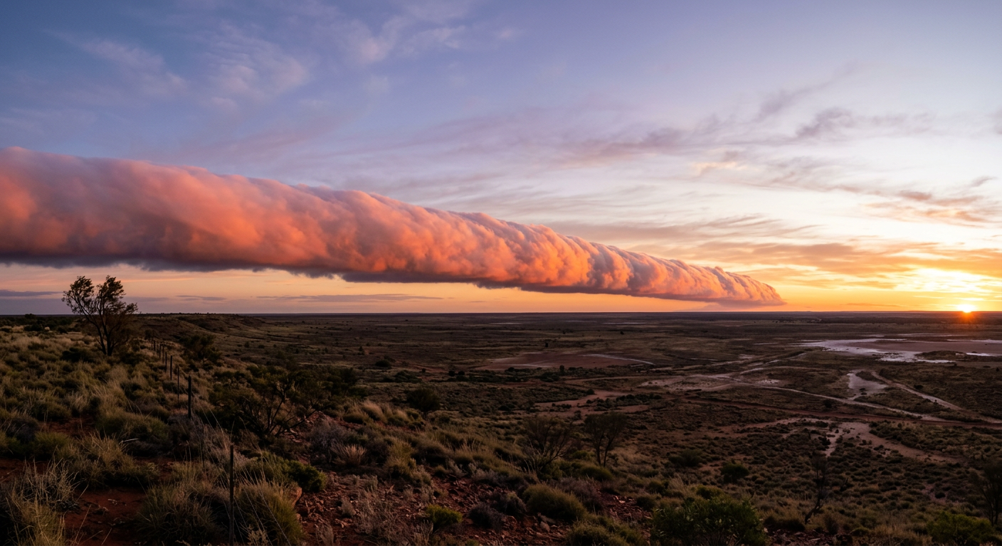
While roll clouds can appear in other parts of the world, the Morning Glory phenomenon stands out because of its size and the regularity of its seasonal appearance in north-west Queensland. Observers often describe it as a rolling cloud band moving steadily across the morning sky. In some cases, the cloud stretches for hundreds of kilometres.
These cloud formations Burketown observers see are not usually linked to frontal storms. Instead, they mark a strong atmospheric disturbance. Some mornings bring a single band, while others produce twin sets or several parallel lines moving one after another. As the cloud passes, people on the ground may notice a squall, a sudden temperature drop and a sharp pressure change.
The Science Behind the Morning Glory Phenomenon
What causes the Morning Glory cloud phenomenon?
The distinctive shape of a Morning Glory cloud is linked to an atmospheric solitary wave, also called an undular bore. As air rises along the leading edge of the wave, moisture can condense into a long cloud band. Air sinking behind the wave helps keep the cloud narrow and well defined.
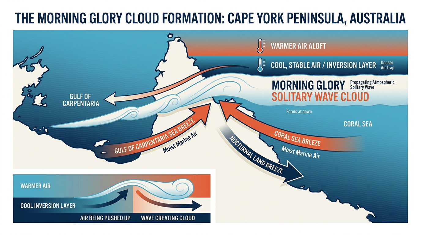
To understand how Morning Glory Clouds form, it helps to look at the geography of Cape York Peninsula. During the dry season, sea breezes can move in from both the Coral Sea and the Gulf of Carpentaria. When those flows meet, they can help set up the wave that later travels across the Gulf overnight. You can locate atmospheric terms in our Weather Glossary.
As evening falls, cooler air near the surface can form an inversion layer. This stable layer can help the wave travel westward across the Gulf of Carpentaria through the night. If there is enough moisture in the lower atmosphere, the rising air at the front of the wave cools and condenses into the cloud band.
Where and When to See the Morning Glory Cloud in Australia
Where can I see the Morning Glory cloud in Australia?
Morning Glory clouds are most often seen in the southern Gulf of Carpentaria, especially around Burketown in Queensland. They attract weather watchers, photographers and glider pilots to the Gulf Country.
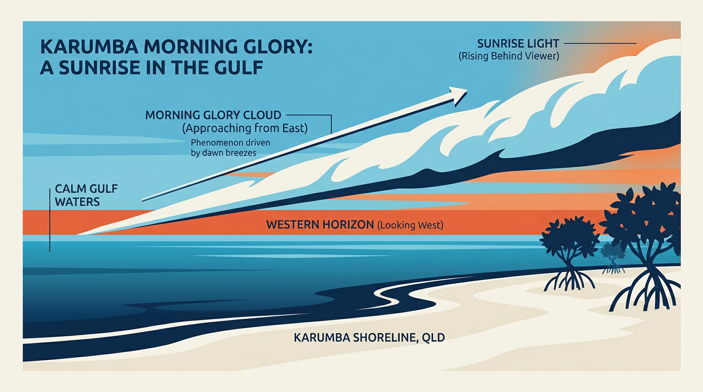
Burketown is one of the best places to watch this roll cloud in Australia because the surrounding country is flat and open. The cloud bands often move in from the north-east across the Gulf plains. Sightings further inland are less common, although stronger waves can sometimes be tracked toward places such as Mount Isa.
When is the best time to see the Morning Glory cloud?
The cloud usually forms before dawn and is most often seen around sunrise. The main viewing season runs from September to November, with the best chances usually in September and October.
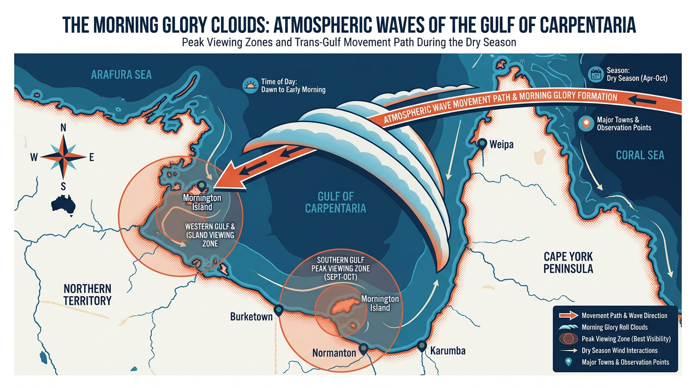
For weather watchers hoping to see the phenomenon, the table below gives a simple guide to common viewing areas in north-west Queensland.
| Viewing location | Best viewing months | Sighting likelihood | Viewing notes |
|---|---|---|---|
| Burketown and Gulf plains | September to October | High in season | One of the best places to see the cloud. |
| Sweers Island | September to November | Moderate to high | Open water can give a clear view of the cloud band. |
| Cape York Peninsula west coast | Late August to October | Moderate | Closer to the source region, but viewing can be limited by timing. |
| Mount Isa and inland Queensland | October | Low | Stronger waves are more likely to reach this far inland. |
Optimal Conditions for Witnessing the Morning Glory Cloud
Chasing morning glory weather takes patience and local knowledge. A clear, stable dry-season sky helps, but the exact timing is hard to predict. Bureau of Meteorology seasonal outlooks can give a sense of the broader dry-to-wet season pattern, yet the cloud itself depends on smaller-scale atmospheric conditions on the day.
Forecasters look for steady weather over northern Australia, along with enough moisture in the lower atmosphere. Sea-breeze interactions across Cape York Peninsula can help set up the wave, while a stable inversion layer can help it survive overnight.
Visitors in Burketown often watch for a humid evening, heavy dew on cars and verandas, and a steady north-easterly breeze. Those signs do not guarantee a sighting, but they can point to a better chance the next morning.
The Morning Glory is a captivating meteorological phenomenon that draws enthusiasts and researchers alike to the Gulf region.
Related guides
Frequently asked questions
A Morning Glory cloud is a rare, long, tubular cloud that appears like a rolling cylinder in the sky. These distinctive clouds can stretch for hundreds of kilometres, often appearing in the mornings.
Source: en.wikipedia.org
Further reading and resources
Explore trusted articles, books, videos and other resources to go deeper on this topic.
www.youtube.comVideo
What is the Morning Glory Cloud glider pilots talk about ... - YouTube
This video provides an explanation of the Morning Glory cloud and its appeal to glider pilots in Australia.
magazine.glidingaustralia.orgArticle
Riding the Morning Glory - Cloud Surfing in the Gulf of Carpentaria
An article from the perspective of glider pilots who actively seek out and ride the Morning Glory cloud.
www.weatherzone.com.auArticle
Rare twin sets of 'morning glory' clouds over Gulf of Carpentaria
This news article details a particularly interesting sighting of twin Morning Glory cloud formations.
cloudatlas.wmo.intReference
cloudatlas.wmo.int
Provides a comprehensive meteorological reference for various cloud formations, including roll clouds.
Why Glider Pilots Are Obsessed With This Rare Australian Cloud ...
A short video explaining the allure of the Morning Glory cloud for glider pilots.
media.bom.gov.auReference
media.bom.gov.au
Explains the science behind various spectacular weather phenomena, including insights relevant to roll clouds.
www.epa.nsw.gov.auReference
www.epa.nsw.gov.au
Arcus Clouds-(Roll or Morning Glory Clouds) - YouTube
Morning Glory Cloud, Roll Cloud, Rare type of Arcus Cloud. Happen quite often in northern Australia.
www.sweers.com.auArticle
Tides & Weather | Sweers Island Resort
The Morning Glory Roll Cloud is often seen in this area during September-October. . Gulf waters are dangerous as conditions can change rapidly. Glass calm ...
www.bom.gov.auReference
Australian Weather Calendar | The Bureau of Meteorology - BoM
Long, flowing clouds lit by the twilight sun roll across the sky over a rocky. Shelf cloud in Coconut Well, Western Australia – Coral Stanley-Joblin. July.
Planning weeks ahead?
Check Australia's long-range seasonal outlook for rainfall, temperature and the climate drivers (ENSO, IOD, SAM, MJO) shaping the next three months.
View Australia's Seasonal Weather Forecast