
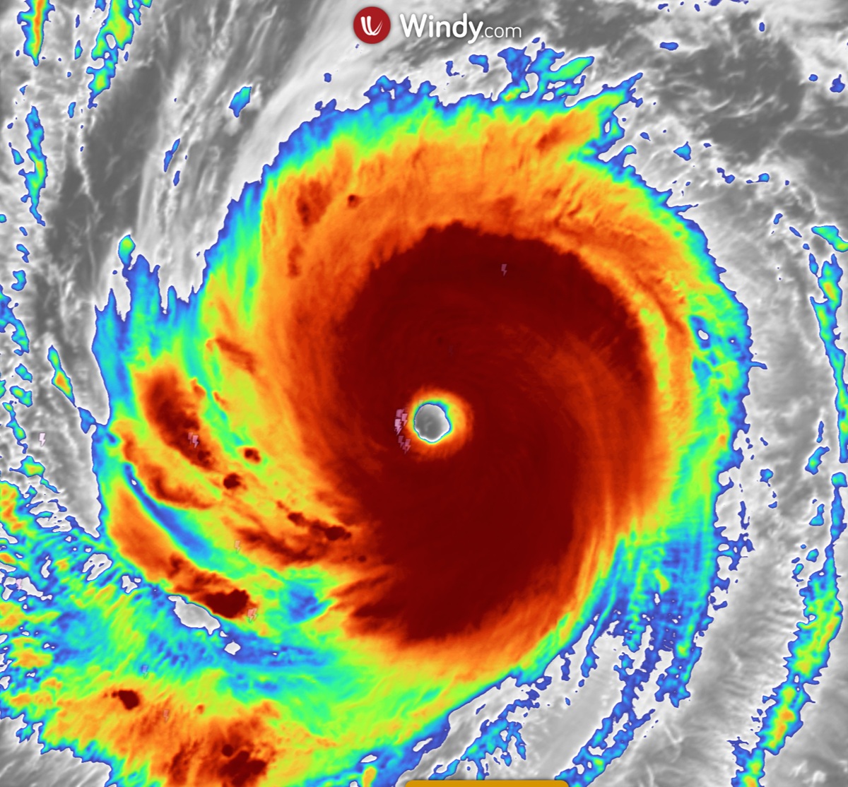
An eyewall replacement cycle is a structural change in a strong tropical cyclone. A new outer ring of thunderstorms forms around the existing eye, then takes over as the main ring of strong winds. Peak winds near the centre can ease for a time, while the wind field spreads out and coastal hazards can reach a wider area.
Key takeaways
- Concentric eyewalls can form in mature tropical cyclones, with an outer eyewall competing with the inner eyewall for moisture and inflow.
- The inner eyewall weakens as the outer eyewall becomes better organised and begins to take over.
- Peak wind speeds near the centre often drop during this transition, but the storm can grow larger.
- A wider wind field can increase the area exposed to damaging winds and storm surge.
- Forecasters use microwave satellite imagery, radar and the Dvorak Technique to spot changes in internal core dynamics.
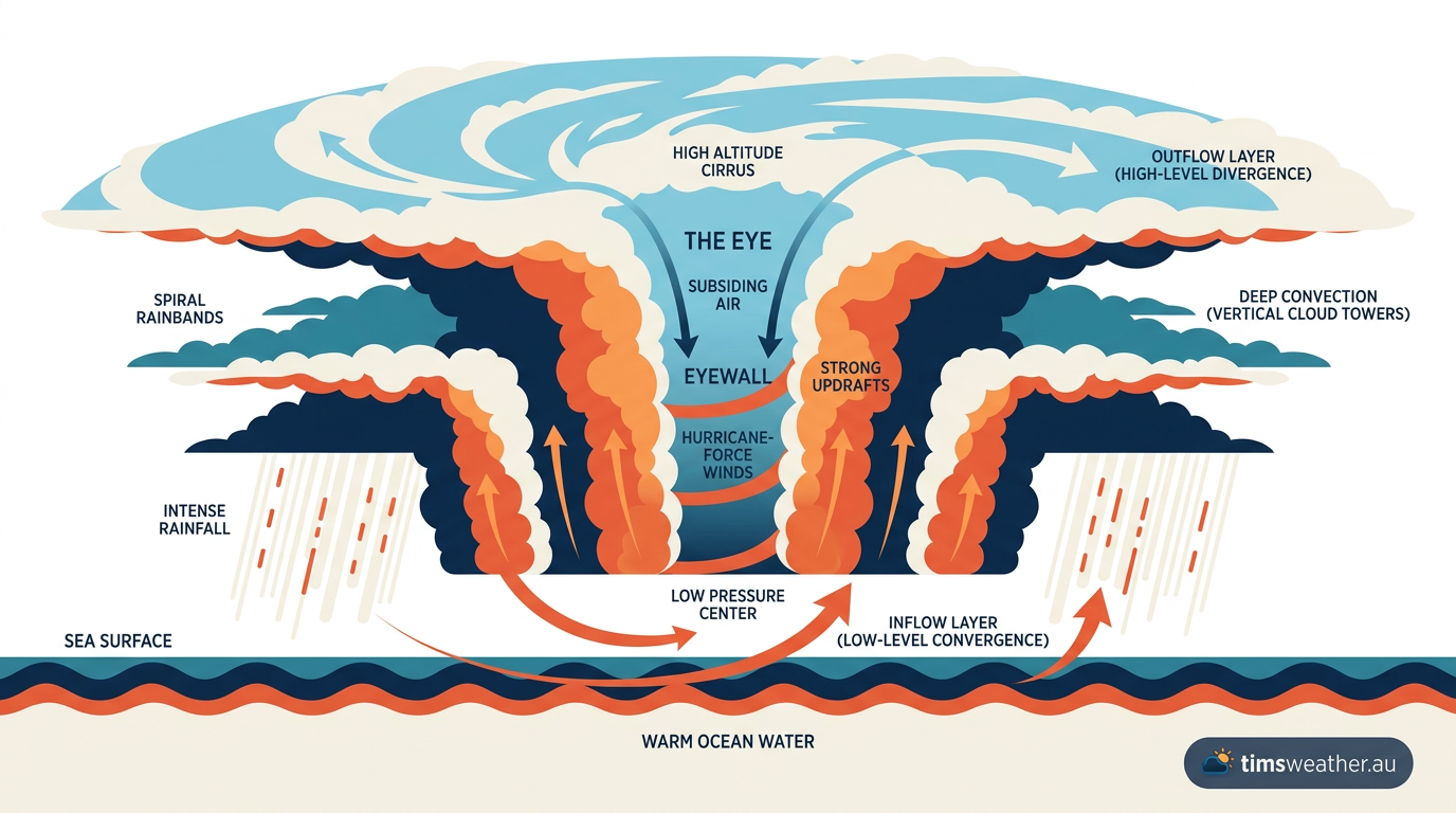
What happens during an eyewall replacement cycle?
An eyewall replacement cycle reorganises the strongest part of a cyclone from the inside out. The Bureau of Meteorology monitors this kind of change when a tropical cyclone is near Australia, because the storm's structure can shift even if the centre stays in roughly the same place. If you are watching a live system, check the Cyclones Hub and the latest warnings.
At first, the cyclone has a tight inner eyewall. Then a secondary eyewall forms outside it. The two rings become concentric eyewalls, with a moat region between them. Over time, the outer eyewall strengthens, the inner eyewall loses its inflow, and the original core weakens. The new outer ring then becomes the main eyewall.
Why does the inner eyewall weaken?
The inner eyewall weakens because the storm can no longer feed it as well. Air spirals inward because of the pressure gradient force, then turns around the centre under the Coriolis effect. As the eyewall contracts, the winds can become very strong near the core. But once the outer eyewall starts drawing in the moist air first, the inner core is cut off from its best fuel source. That reduces latent heat release in the inner ring, which helps the thunderstorms there collapse.
What is the moat region?
The moat region is the relative gap between the inner and outer eyewalls. The Hong Kong Observatory describes it as an area where sinking air can suppress cloud growth. In simple terms, the moat is a quieter ring between two stronger rain rings. It is one sign that the cyclone's internal core dynamics are changing.
Why storms can grow larger while weakening
An eyewall replacement cycle can lower the strongest winds for a period, but the overall storm can spread out. That is because the main circulation shifts to a larger radius. Angular momentum still matters, but it is now spread through a broader ring of air.
Think of a spinning skater. Pull the arms in, and the spin tightens. Move the arms out, and the rotation broadens. A cyclone does something similar. When the eyewall moves outward, the strongest winds are no longer packed into such a small circle. The storm may have a lower peak, but the damaging wind field can cover a wider area.
This is one reason storm surge expansion matters. A larger wind field can push more water toward the coast over a longer stretch of shoreline. If you live near the coast, watch the warnings and any cyclone updates from the Bureau of Meteorology.
| Stage | What is happening | Practical effect |
|---|---|---|
| Single eyewall | The cyclone has one compact core of strong winds | Wind damage is focused close to the centre |
| Secondary eyewall forms | Outer bands organise into a second ring | Forecasts may change as the core starts to restructure |
| Moat region develops | A gap opens between the two eyewalls | The storm can look less organised on some images, but still remain dangerous |
| Outer eyewall takes over | The inner eyewall fades and the outer ring becomes dominant | The wind field can expand while the peak near-centre wind eases |
How forecasters track internal core dynamics
Eyewall replacement cycles are hard to see from one standard satellite image. Forecasters look for them using several tools, including microwave satellite imagery, radar, and the Dvorak Technique. Those methods help them read the cyclone's tropical cyclone structure when cloud tops hide what is happening lower down.
Microwave satellite imagery
Microwave satellite imagery is useful because it can show rainbands and the inner ring structure through clouds that block visible and infrared views. That makes it one of the best ways to spot concentric eyewalls and a forming secondary eyewall. The Bureau of Meteorology and overseas agencies use this kind of data when a cyclone is close enough to affect land.
The Dvorak Technique
The Dvorak Technique estimates cyclone intensity from cloud pattern and structure. It does not see everything inside the storm, but it gives forecasters a consistent way to assess whether the cyclone is organising or weakening. During an eyewall replacement cycle, that estimate can change as the core shifts and the central cloud pattern changes.
Why radar matters near land
Once a cyclone is close to the coast, radar becomes very helpful. It can show the location of the eyewall, rainbands and gaps in the rain shield. If the inner eyewall collapses and the outer eyewall is still tightening, radar can show the change before it becomes obvious at the surface. For people in Queensland, the Northern Territory or Western Australia, this can make a real difference to timing, especially if the system is moving near populated coastlines.
How eyewall replacement cycles affect forecasts
These cycles can make intensity forecasting harder. A cyclone may weaken for a short time, then re-strengthen once the new eyewall contracts. The size of the wind field may also keep changing as the cycle continues. That is why forecasters look beyond the category number alone.
In Australia, the Bureau of Meteorology uses the Australian tropical cyclone scale, not the Saffir-Simpson Scale. Category tells you about wind speed near the centre, but it does not tell the full story about storm size, rainfall, surge or how far damaging winds may reach. A broader cyclone can still bring serious impacts even while peak winds are easing.
If you want a plain-English refresher on storm alerts, see understanding weather warnings and cyclone preparedness. If you are unsure about terms such as eyewall, eye or tropical low, the weather glossary can help.
Why this matters for Australian communities
For Australian coastal communities, the main message is simple: a cyclone can change shape without losing all of its risk. An eyewall replacement cycle may reduce the sharpest winds near the centre for a time, but the larger wind field can widen the area exposed to damaging conditions, including storm surge, heavy rain and gusty winds.
If you live in a coastal area, keep checking the latest Bureau of Meteorology advice, especially if a cyclone is approaching from the Coral Sea, Gulf of Carpentaria or Indian Ocean. Structural changes inside the storm can alter the forecast track, wind extent and timing of impacts.
Frequently asked questions
An eyewall replacement cycle occurs when a new ring of thunderstorms forms outside the original eyewall and eventually consumes its energy. This process causes the inner eyewall to weaken and collapse, leaving a larger, new eye at the centre of the storm. It often makes the cyclone grow in physical size.
Source: aoml.noaa.gov
Further reading and resources
Explore trusted articles, books, videos and other resources to go deeper on this topic.
en.wikipedia.orgReference
Eyewall replacement cycle
Background reference on What is an Eyewall Replacement Cycle? Cyclone Evolution Explained from en.wikipedia.org.
tropical.colostate.eduReference
Doppler Radar Analysis of the Eyewall Replacement Cycle of Hurricane ...
Background reference on What is an Eyewall Replacement Cycle? Cyclone Evolution Explained from tropical.colostate.edu.
aoml.noaa.govReference
Paper on the unusual eyewall replacement cycles in Hurricane ...
Background reference on What is an Eyewall Replacement Cycle? Cyclone Evolution Explained from aoml.noaa.gov.
Eyewall replacement cycle
Background reference on What is an Eyewall Replacement Cycle? Cyclone Evolution Explained from tropical.colostate.edu.
Paper on how eyewall replacement cycles start published in The Journal ...
Background reference on What is an Eyewall Replacement Cycle? Cyclone Evolution Explained from aoml.noaa.gov.
aos.wisc.eduReference
INVESTIGATION AND PREDICTION OF HURRICANE EYEWALL ...
Background reference on What is an Eyewall Replacement Cycle? Cyclone Evolution Explained from aos.wisc.edu.
hurricaneville.comArticle
Eyewall Replacement Cycle
In-depth coverage on What is an Eyewall Replacement Cycle? Cyclone Evolution Explained from hurricaneville.com.
theweatherprediction.comArticle
EYEWALL REPLACEMENT CYCLE
In-depth coverage on What is an Eyewall Replacement Cycle? Cyclone Evolution Explained from theweatherprediction.com.
journals.ametsoc.orgArticle
Documenting the Progressions of Secondary Eyewall Formations in
In-depth coverage on What is an Eyewall Replacement Cycle? Cyclone Evolution Explained from journals.ametsoc.org.
The Rapid Intensification and Eyewall Replacement Cycles of Hurricane ...
In-depth coverage on What is an Eyewall Replacement Cycle? Cyclone Evolution Explained from journals.ametsoc.org.
Planning weeks ahead?
Check Australia's long-range seasonal outlook for rainfall, temperature and the climate drivers (ENSO, IOD, SAM, MJO) shaping the next three months.
View Australia's Seasonal Weather Forecast