

Lee waves clouds are stationary, lens-shaped clouds that form when stable air flows over mountain ranges. As the air rises and falls in standing waves on the lee side, moisture condenses near the wave crests and evaporates lower down, so the cloud deck appears fixed while the wind continues to move through it.
Key takeaways
- Lee waves form when steady winds cross terrain such as the Great Dividing Range and the Australian Alps.
- They can show up as lenticular clouds, cap clouds and rotor clouds downwind of the ridge.
- A stable air layer helps the wave motion stay organised instead of breaking into ordinary mixing.
- The Bureau of Meteorology issues SIGMETs for severe mountain waves when estimated accompanying downdrafts are 600FT/min or more, and treats them as distinct from SIGMETs for severe turbulence, not as a warning sign for wave-induced turbulence.
- The same wave pattern can extend well above the terrain, including into the upper atmosphere.

What lee waves clouds are
Lee waves clouds are the cloud tops of an atmospheric wave pattern. The wind crosses a mountain barrier, the air is lifted, then it sinks and rises again on the lee side. If the air is moist enough and cools to its dew point at the top of the wave, a cloud forms. If the air sinks out of that moist layer, the cloud fades away just as quickly.
That is why the cloud can sit in the same place for a long time while the air itself keeps moving. The cloud marks the wave crest, not a patch of still air. In Australian weather writing, these clouds are often called altocumulus lenticularis, which is the formal cloud name used for smooth lenticular forms.
How mountain waves work
Mountain waves are a type of atmospheric gravity wave. A gravity wave forms when air is displaced and then pulled back toward balance by gravity and buoyancy. Over a ridge, the airflow is forced upward. If the air is stable, it resists that lift and tries to return to its earlier level. That back-and-forth motion sets up a standing wave downwind of the range.
Two things matter most. The air needs to be stable, and the wind needs to cross the terrain at a useful angle and speed. If the airflow is too chaotic, the wave pattern breaks up. If the air is stable and the wind keeps moving cleanly over the range, the wave train can persist for a long distance.
Why stable air layers matter
A stable air layer acts like a spring. When a parcel of air is lifted, it becomes cooler and denser than its surroundings. Gravity then pulls it back down. If it overshoots, it rises again. That repeated motion is what creates the oscillation.
This is why stable conditions are so important for lee waves clouds. Without stability, the air mixes more freely and the motion becomes less organised. In a stable layer, the wave can stay neat enough for a cloud to form at the crest.
What isentropic surfaces show
Meteorologists use isentropic surfaces to describe air moving along lines of equal potential temperature. In simple terms, these surfaces help show how an air mass can glide in layers rather than mix vertically. In a mountain wave setup, airflow can run along these sloping surfaces as it rises over terrain and then sinks on the lee side.
That layered motion helps explain why the cloud can look smooth and stacked. It also helps explain why the wave can hold together for a long time. The air is not tumbling randomly. It is moving in a repeatable pattern.
What the Brunt-Vaisala frequency tells forecasters
The Brunt-Vaisala frequency is a measure of atmospheric stability. It describes how quickly a displaced parcel of air will move up and down within a stable layer. A stronger value means the atmosphere resists vertical motion more strongly, which supports organised wave motion.
Forecasters use that idea, along with wind direction and wind speed with height, to judge whether mountain waves are likely. When the stability is strong enough, the flow can stay smooth on the windward side and then form a wave train downwind.
Where lee waves clouds appear in Australia
These clouds are most common where strong winds cross high terrain. In Australia, that includes the Great Dividing Range and the Australian Alps. Any range with a steady cross-flow can set up mountain waves, but those eastern ranges are well known for it. Identifying these is part of identifying orographic clouds across the continent.
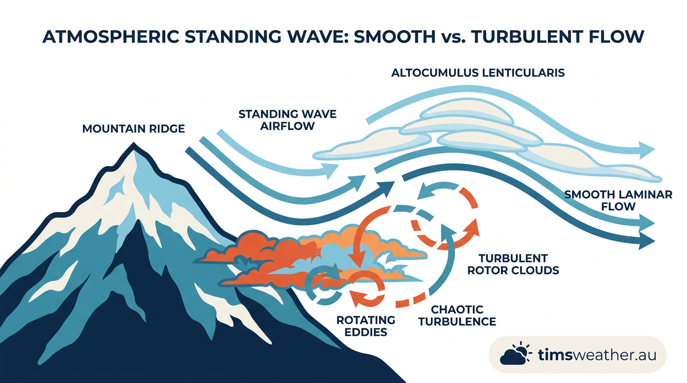
If you are looking at the sky near a mountain range, watch the windward and lee sides. The windward side often has smoother cloud bases and rising air. The lee side can show smooth lenticular clouds, broken rotor clouds and a clear gap under the wave cloud itself. That pattern is a clue that the air is flowing over, then down, then back up again.
Great Dividing Range and eastern Australia
The Great Dividing Range is a major terrain barrier along the east of the continent. When winds cross it, the airflow can set up waves that stretch far downwind. This is one reason wave clouds are often linked with eastern Australia.
On some days the cloud forms directly over the ridge. On others it sits a little downwind. The exact position depends on the depth of the stable layer, the wind speed and the shape of the terrain. Long, smooth ridges tend to produce cleaner wave trains than short, broken hills.
Australian Alps and foehn wall patterns
The Australian Alps are another strong mountain-wave region. Moist air on the windward side can rise, cool and shed cloud or precipitation. Downwind, the air descends, warms and dries. That can leave a sharp cloud edge near the ridge and clearer air on the lee side. Meteorologists often call that sharp edge a foehn wall.
A foehn wall is a useful visual clue. It can show where the moist air has been lifted and where the drier sinking air begins. For glider pilots, it can also mark the edge of a wave zone where lift may be strong but turbulence can build nearby.
Cap clouds and rotor clouds
Cap clouds form when moist air is forced up a mountain slope and cools to its dew point, typically wrapping around the peak rather than being held near the top. They often sit like a cap on the summit or just over the ridge. They can be one of the first signs that the flow is being forced upward strongly enough to make clouds.
Rotor clouds are different. They form lower down, near the spinning eddies that can develop beneath the wave. Rotor clouds can look ragged, broken and fast-moving. They are a warning sign because rotor zones can be rough, even when the lenticular cloud above looks smooth.
Why lee waves clouds matter for aviation
Lee waves clouds matter because the cloud is only the visible part of a larger wind pattern. The wave itself can create strong updrafts, downdrafts and wave-induced turbulence. Pilots may use the wave lift, but they also need to watch for rough air in the rotor zone and sharp changes in vertical speed. Detailed aviation weather information helps identify these hazards.
The Bureau of Meteorology provides aviation weather information that helps pilots assess these conditions. If you fly near mountain ranges, wave clouds can signal stronger-than-usual vertical currents even when the sky looks clean and smooth. A smooth cloud does not mean smooth air.
Laminar flow and why it can turn dangerous
Laminar flow means the air moves in clean layers with little mixing. That kind of flow can help a mountain wave stay organised. It can also make the wave more efficient at building strong vertical motion.
For pilots, that is the tricky part. The same clean flow that allows a neat lenticular cloud can also support strong lift on one side of the wave and sinking air on the other. The cloud is tidy. The air around it may not be.
Identifying lee waves on BOM satellite imagery
Identifying lee waves on BOM satellite imagery usually starts with looking for a line or row of fixed cloud elements downwind of a ridge. The cloud tops are often smooth and evenly spaced. They may sit in the same place for hours while the surrounding cloud field drifts past. Studies have shown these lee-waves clouds can extend significantly downwind from great mountains.
Satellite imagery can also show a clear lee-side gap, curved cloud bands and aligned wave clouds downstream of the mountains. Those patterns fit a standing wave rather than a moving weather front. If you know the terrain below, the shape of the cloud field makes more sense.
How to read the sky for mountain waves
You do not need to be a pilot to spot the pattern. The main clue is shape. Look for smooth, lens-like clouds that stay put above or downwind of a ridge. Then look for broken cloud or swirling lower cloud closer to the terrain. Together, those features point to a wave and rotor setup.
Other hints include a sharp cloud edge near the mountains, clear air on the lee side and cloud bands that repeat at regular spacing. The spacing is part of the wave pattern. It reflects the atmosphere bouncing between layers of stability rather than drifting in a random way.
When the cloud is not a wave cloud
Not every lens-shaped cloud is a mountain wave cloud. Some clouds look similar because of their shape, but they form for different reasons. A smooth cloud over flat country may be caused by another layer of rising air. A band of broken cloud may come from a front rather than a wave.
The terrain below is the best clue. If the cloud lines up with a ridge and stays fixed while the wind keeps blowing, mountain waves are a good fit. If the cloud keeps moving with the rest of the weather system, another process may be at work.
What to watch for near mountain ranges
If you are in a mountain area, keep an eye out for a few signs:
- smooth lenticular clouds parked above or downwind of a ridge
- cap clouds sitting on the summit or crest
- broken rotor clouds lower down
- a clear lee-side gap with rougher air near the terrain
- repeating cloud bands that do not move much
For aviation, the main point is simple. The visible cloud can tell you the wind is doing something organised and powerful. If you are on the ground, the cloud is still worth watching because it shows how the air is flowing over the terrain above you. You can check the weather glossary for technical terms related to these flows.
Frequently asked questions
Lee wave clouds form when stable air is forced over a mountain range and oscillates downwind, creating standing waves. If the air cools sufficiently at the wave crest, moisture condenses into a cloud. These often appear as smooth, lens-shaped formations that remain stationary despite high wind speeds.
Source: bom.gov.au
Further reading and resources
Explore trusted articles, books, videos and other resources to go deeper on this topic.
user.eumetsat.intArticle
Mountain waves in satellite imagery — 2002-2020
Detailed satellite case studies showing how lee wave cloud bands appear from space.
www.bom.gov.auReference
Aviation Weather: Wind Shear and Mountain Waves
A technical reference for pilots on the hazards of mountain wave downdrafts and turbulence.
ts.ostiv.orgArticle
Experimental Study of Mountain Lee-Waves
Scientific analysis of lee wave cloud formation downwind of major terrain barriers.
acp.copernicus.orgArticle
Ice Formation in Lee Waves Clouds
Highly technical exploration of the microphysics and ice formation within wave clouds.
Planning weeks ahead?
Check Australia's long-range seasonal outlook for rainfall, temperature and the climate drivers (ENSO, IOD, SAM, MJO) shaping the next three months.
View Australia's Seasonal Weather Forecast