

A pyrocumulonimbus cloud is a powerful weather system that forms when intense heat from a bushfire causes air to rise rapidly. Also called a fire cloud or fire-generated storm, it can produce lightning, dangerous winds, and dry lightning that complicates firefighting efforts across Australia.
Key takeaways
- A pyrocumulonimbus cloud forms when a severe bushfire creates an updraft strong enough to build a cumulonimbus cloud.
- These smoke-induced storms can carry ash and particles 10 to 15 kilometres into the atmosphere, reaching the stratosphere.
- They can produce lightning, strong winds, and fire whirls, and can fling burning embers up to 40 kilometres ahead of a fire front.
- The Australian Bureau of Meteorology tracks these events because they can intensify fire behaviour and create dangerous weather near the fireground.
Pyrocumulonimbus cloud explained
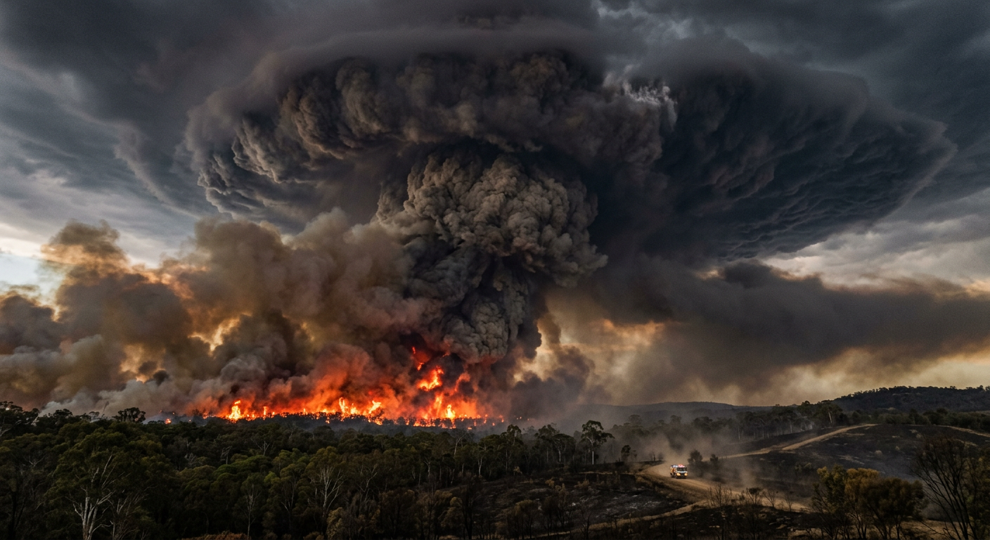
Unlike an ordinary thunderstorm, a pyrocumulonimbus cloud draws much of its energy from a wildfire. When a fire burns intensely across a large area, it heats the air above it. That air rises quickly in a narrow column and lifts smoke, ash, and moisture high into the atmosphere.
As the plume rises into cooler air, water vapour condenses and releases latent heat. That extra heat helps the updraft grow further. If the atmosphere is unstable enough, the cloud can rise into a full cumulonimbus cloud with an anvil shape.
What does pyrocumulonimbus mean?
Pyrocumulonimbus is the term meteorologists use for a thunderstorm cloud driven by fire. The shorter term pyroCb is also used. A pyrocumulus cloud is smaller and does not reach the height needed for lightning or thunder.
Once the plume reaches freezing levels, ice crystals can form and collisions between particles can build electrical charge. That can lead to lightning and thunder over or near the fireground.
How pyrocumulonimbus clouds form

A fire-generated storm needs three main ingredients: intense heat from a wildfire, very dry fuels, and an atmosphere that allows strong vertical growth. If these conditions line up, the plume can rise well above the fire and build a storm cloud.
The Australian Bureau of Meteorology watches these events closely because they can change wind direction, spread embers, and make fire behaviour harder to predict. Smoke from the fire can also reduce visibility for aircraft and ground crews.
| Feature | Pyrocumulonimbus cloud | Natural cumulonimbus cloud |
|---|---|---|
| Main trigger | Intense heat from a wildfire or large fire | Solar heating, fronts, or troughs |
| Source of moisture | Atmospheric moisture and water vapour released from burning vegetation | Moist air from the environment |
| What it contains | Smoke, ash, soot, ice crystals | Water droplets and ice crystals |
| Hazards | Lightning, strong winds, fire whirls, ember showers | Heavy rain, hail, flash flooding, strong winds |
Why pyroCb storms are dangerous

A pyrocumulonimbus cloud can make a fire burn hotter and spread more quickly. Strong downdrafts can hit the ground with force and create unsafe conditions for firefighters. The storm can also generate fire whirls, which are spinning columns of hot air, smoke, and flame.
These storms can also produce lightning. If rain falls from the cloud, it may evaporate before it reaches the ground, leaving dry lightning strikes that can start new fires away from the main fire front. Burning embers can also be carried long distances, including up to 40 kilometres ahead of a fire.
Because the cloud behaves like a cumulonimbus cloud but is driven by fire, it can also bring heavy rain, hail, and sudden changes in wind. In some cases, that can cause flash flooding near or downstream from the fireground.
Pyrocumulonimbus cloud in Australia

Australia has had many recorded pyroconvective storms. Research cited by Australian Geographic notes at least 60 recorded pyroconvective storms in the 40 years leading up to 2018.
Notable examples include the Canberra fires in 2003 and the Black Saturday fires in 2009, both of which saw intense thunderstorms caused by bushfires. During the Black Summer of 2019-2020, these events became more common. Research cited in the article says there were at least 45 pyroconvective events that season.
Observations also show more dangerous conditions for bushfires are occurring during summer in southern and eastern Australia. Human-caused climate change is contributing to those conditions by increasing the chance of extreme heat, low humidity, and dry fuels lining up at the same time.
How meteorology helps track pyroCb events
Meteorology plays a key role in tracking pyrocumulonimbus clouds. Forecasters look for strong fire heat, unstable air, and deep smoke plumes that can grow into storm clouds. Radar and satellite images help show how high the cloud is rising and whether it is spreading new smoke or lightning into nearby areas.
These signs can help emergency services plan for sudden wind changes, new ignitions, and reduced visibility. They also help explain why some bushfire thunderstorm events behave so differently from ordinary summer storms.
Related guides
Frequently asked questions
A pyrocumulonimbus cloud is a thunderstorm cloud formed by the intense heat from a fire, such as a bushfire or volcanic eruption. It can produce lightning and strong winds, and sometimes dry lightning that can start new fires.
Source: bom.gov.au
Further reading and resources
Explore trusted articles, books, videos and other resources to go deeper on this topic.
www.bom.gov.auReference
How fires make thunderstorms
This article from the Bureau of Meteorology provides a detailed explanation of how pyrocumulonimbus clouds form from fires.
www.youtube.comVideo
What are pyrocumulonimbus clouds? - YouTube
A short video explaining the basics of pyrocumulonimbus clouds and how they are generated by bushfires.
science.nasa.govArticle
Flying through a Fire Cloud
NASA's Earth Observatory provides insights into the phenomenon of fire clouds, also known as pyrocumulonimbus clouds, from a scientific perspective.
www.theguardian.comBook
'Like Nagasaki': devastating wildfires will only get worse, new book ...
This book offers a deeper look into the devastating impact of wildfires and related phenomena like pyrocumulonimbus clouds, discussing their increasing frequency.
Weird Weather: Pyrocumulonimbus | The Bureau of Meteorology
A video from the BoM's 'Weird Weather' series, specifically focusing on pyrocumulonimbus clouds and their extreme nature.
www.abc.net.auArticle
Pyrocumulonimbus cloud forms over Victorian bushfire - ABC News
This news article details a specific instance of a pyrocumulonimbus cloud forming over a Victorian bushfire, providing a real-world example.
What is a pyroCB, a fire-generated thunderstorm? - ABC News
Pyrocumulonimbus clouds (pyroCb), also known as are fire generated thunderstorms, are a dangerous fire behaviour that occurs during extreme bushfires. Australia ...
Pyrocumulonimbus Clouds - YouTube
It looks like a scene right out of Game of Thrones - but this is real life. Derek Kevra explains how Pyrocumulonimbus clouds form.
cpo.noaa.govReference
Pyrocumulonimbus clouds Archives - Climate Program Office - NOAA
Pyrocumulonimbus clouds. Pyrocumulonimbus clouds forming above a wildfire on a distant ridge · Black carbon's role in firestorm-induced climate effects. A new ...
media.bom.gov.auReference
When bushfires make their own weather - Social Media Blog - BoM
What are pyrocumulonimbus clouds? They're a thunderstorm that forms in the smoke plume of a fire (or nuclear bomb blast, or volcanic ash cloud).
Planning weeks ahead?
Check Australia's long-range seasonal outlook for rainfall, temperature and the climate drivers (ENSO, IOD, SAM, MJO) shaping the next three months.
View Australia's Seasonal Weather Forecast