
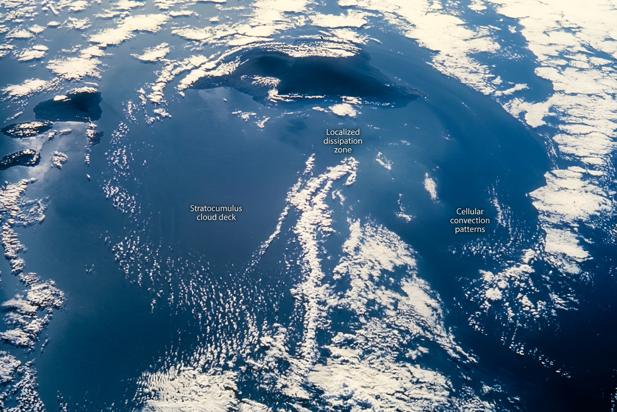
Stratocumulus cloud formation occurs when moist air rises into a stable layer, then spreads sideways instead of building tall. The result is a low cloud deck made up mostly of water droplets. These clouds are common where the lower atmosphere stays damp and capped by warmer air above.
Key takeaways
- Along Australia's south-west and south-east coasts, low cloud decks often form where cool sea air moves under a stable layer.
- Low clouds are usually made of water droplets, not ice crystals.
- These clouds often sit in the marine layer, where cool sea air helps keep the lower atmosphere moist.
- Cloud condensation nuclei give water vapour surfaces to condense onto.
- Stratocumulus can look similar to nimbostratus, but nimbostratus is more likely to bring steady rain.
What stratocumulus cloud formation means
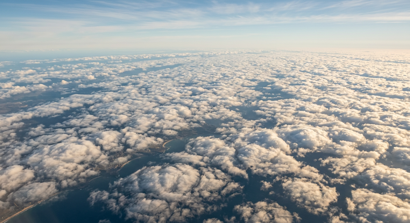
Stratocumulus clouds are low clouds that often appear as a grey or white sheet with rounded lumps. The NOAA cloud classification guide says low clouds are usually made of water droplets. That is why stratocumulus often looks thick and dull from below, yet bright from above when seen by satellites.
They form in the lower atmosphere, where air can stay cool and moist without rising far. If a stable layer sits above that air, the cloud cannot grow tall. It spreads out instead, building a wide deck.
How stratocumulus clouds form
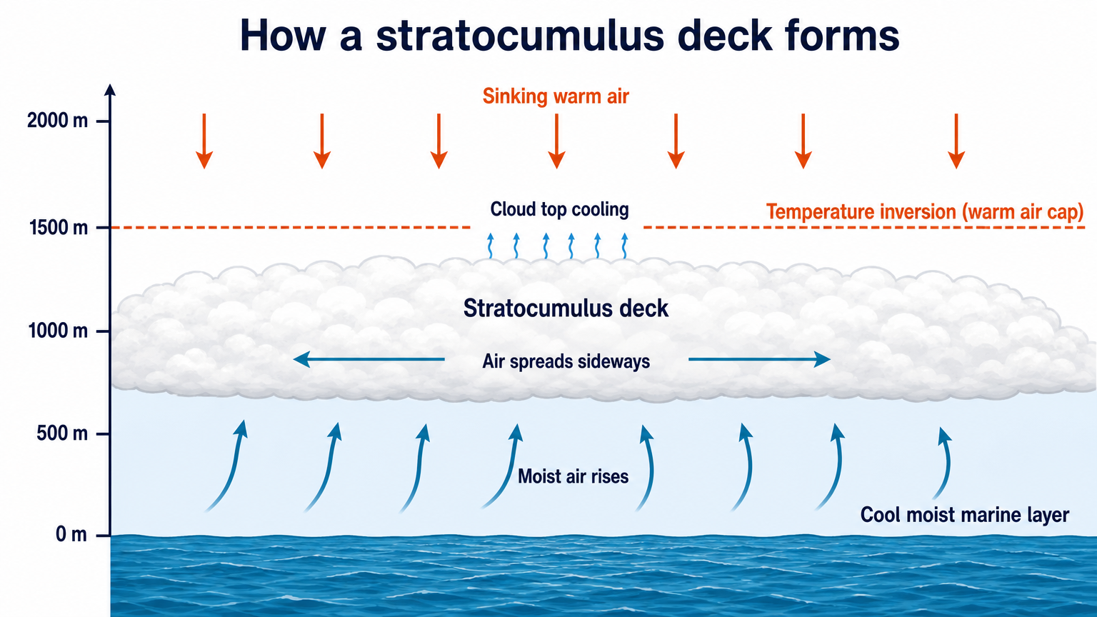
Stratocumulus cloud formation happens when rising moist air reaches a stable cap and is forced to spread sideways. The cloud stays low because the air above it resists further rise. This is a common pattern in boundary layer meteorology, especially over cooler seas.
Atmospheric stability and convection
Stratocumulus needs weak convection and strong atmospheric stability. The air near the surface rises a little, cools, then stops at the inversion. That inversion is a temperature reversal, with warmer air above cooler air. Once that happens, the cloud layer flattens out into a low-level cloud deck instead of growing into taller cloud forms.
The ABC Education guide notes that cloud shape can tell you a lot about the air above it. In practice, a broad stratocumulus layer usually points to stable air and limited vertical growth.
Why the marine layer matters
The marine layer helps support stratocumulus cloud formation because it keeps the lower atmosphere cool and moist. Over the ocean, that air often stays capped by warmer air aloft. The cloud then spreads across a large area, sometimes moving inland with the sea breeze.
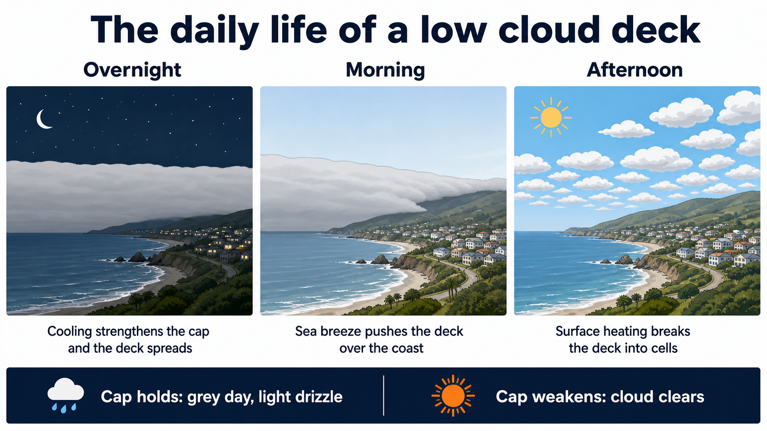
This is why coastal forecasts often mention a low cloud deck or broken low cloud, especially on cool mornings. If the cap stays strong, the cloud may linger well into the day.
Cloud condensation nuclei and droplet formation
Water vapour needs tiny particles to condense onto. These particles are called cloud condensation nuclei. The Science News Explores overview explains that clouds are made of tiny aerosols and water droplets suspended in the air. Over the ocean, sea salt provides many of these nuclei, which helps droplets form in large numbers.
Many small droplets make the cloud look bright and smooth from above. That also helps explain why stratocumulus can reflect a fair amount of incoming sunlight.
Cloud albedo effect and the global radiation budget
Stratocumulus clouds matter because they reflect sunlight back to space. This is the cloud albedo effect. In broad terms, more reflection means less solar energy reaches the surface, which is why low cloud decks can help keep coastal areas cooler during the day.
That reflects a larger part of the global radiation budget. Low marine clouds are one reason the ocean and atmosphere exchange heat in a different way over the sea than over dry land.
How to tell stratocumulus from nimbostratus
Stratocumulus and nimbostratus can both look grey and layered, but they do different jobs in the sky. Stratocumulus usually appears as a lumpy sheet with breaks or texture. Nimbostratus is thicker, darker, and more likely to bring steady rain.
- Stratocumulus: low, lumpy, widespread, often little or no rain.
- Nimbostratus: thicker, darker, more uniform, usually rain-bearing.
If you are reading a coastal forecast, that difference matters. A stratocumulus deck often means a grey day. Nimbostratus more often means rain on the way.
What Australian weather watchers should look for
In Australia, stratocumulus often shows up where cool marine air moves under a stable layer. That can happen along the south-west and south-east coasts, especially when the sea breeze feeds moist air inland. The low cloud deck may break up after sunrise, or it may hold on if the inversion stays strong.
If you want one simple rule, look for cool air near the surface, a stable layer above it, and a broad grey cloud sheet that does not grow upward.
Useful terms for coastal forecasts
- Boundary layer: the part of the atmosphere closest to the surface.
- Temperature inversion: a layer where warmer air sits above cooler air.
- Entrainment: mixing of air from outside the cloud layer into the cloud.
- Marine layer: cool, moist air over the ocean.
Related guides
Frequently asked questions
Stratocumulus clouds form when moist marine air is lifted and cools to its dew point, causing water vapour to condense. A stable layer of air above the cloud deck, known as a temperature inversion, stops vertical growth. This forces the clouds to spread out into a broad, flat layer.
Source: nesdis.noaa.gov
Further reading and resources
Explore trusted articles, books, videos and other resources to go deeper on this topic.
cpo.noaa.govReference
AC4-funded project publishes paper on marine stratocumulus ...
Background reference on How stratocumulus cloud formation works in marine layers from cpo.noaa.gov.
weather.govReference
What are Marine Layer Clouds and How Do They Form?
Background reference on How stratocumulus cloud formation works in marine layers from weather.gov.
headlines.ametsoc.orgArticle
A Day in the Life of Stratocumulus - AMS Headlines
In-depth coverage on How stratocumulus cloud formation works in marine layers from headlines.ametsoc.org.
asr.science.energy.govReference
Mesoscale Organization in Cumulus-Coupled Marine ...
Background reference on How stratocumulus cloud formation works in marine layers from asr.science.energy.gov.
en.wikipedia.orgReference
Marine stratocumulus
Background reference on How stratocumulus cloud formation works in marine layers from en.wikipedia.org.
acp.copernicus.orgArticle
Investigating the development of clouds within marine cold- ...
In-depth coverage on How stratocumulus cloud formation works in marine layers from acp.copernicus.org.
user.eumetsat.intArticle
Global warming speeds up as warmer oceans reduce ...
In-depth coverage on How stratocumulus cloud formation works in marine layers from user.eumetsat.int.
Stratocumulus cloud
Background reference on How stratocumulus cloud formation works in marine layers from en.wikipedia.org.
climate-dynamics.orgArticle
REVIEW Stratocumulus Clouds
In-depth coverage on How stratocumulus cloud formation works in marine layers from climate-dynamics.org.
Cloud Classification
Background reference on How stratocumulus cloud formation works in marine layers from weather.gov.
Planning weeks ahead?
Check Australia's long-range seasonal outlook for rainfall, temperature and the climate drivers (ENSO, IOD, SAM, MJO) shaping the next three months.
View Australia's Seasonal Weather Forecast