
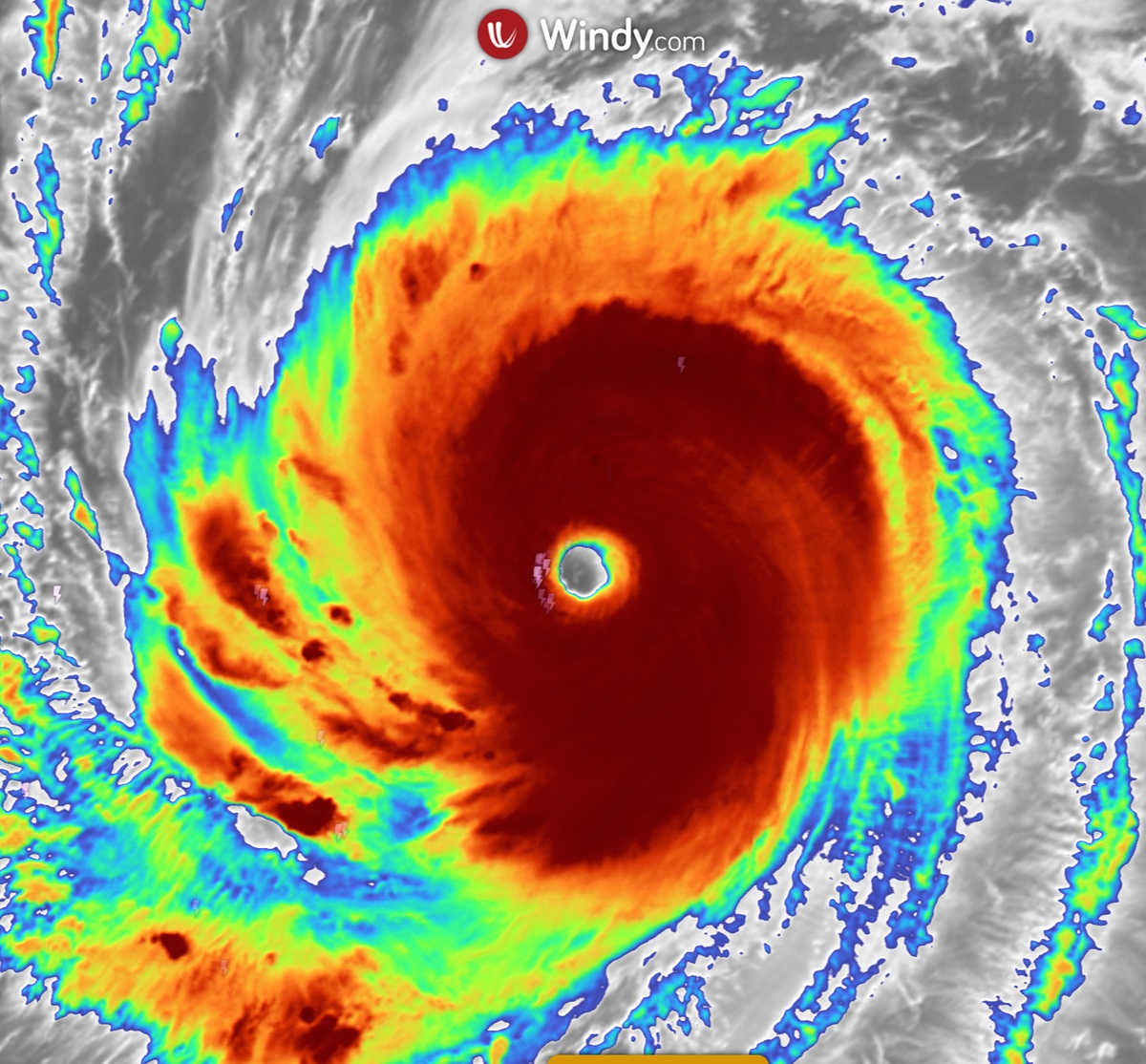
Typhoon Dolphin (12W) is passing Okinawa right now. In its latest bulletin — Warning No. 46, issued 09:00 UTC on 7 August 2026 — the US Joint Typhoon Warning Center (JTWC) placed the centre roughly 37 km (20 nautical miles) north-east of Kadena Air Base on Okinawa, with 1-minute sustained winds of 90 kt (about 165 km/h), gusts to 110 kt (about 205 km/h) and a minimum central pressure of 951 hPa. That is roughly a Category 2 hurricane equivalent. This update is current as at 9:30pm AEST, Friday 7 August 2026.
The Okinawa approach we flagged earlier in the week has arrived. From here the official forecast turns Dolphin west and then west-north-west across the East China Sea, with JTWC now showing it moving inland over eastern China around 10 August and dissipating over land. Mainland Japan stays off the forecast track.
Where Typhoon Dolphin is right now
These are the official JTWC numbers from the 06:00 UTC 7 August warning position:
Position: 26.7°N 128.1°E — essentially on top of Okinawa, about 37 km north-east of Kadena Air Base. The 09:00 UTC fix had it near 26.7°N 127.7°E, just west of the island.
Maximum sustained winds: 90 kt — about 165 km/h, gusting to 205 km/h. On the Saffir-Simpson scale that is a Category 2 equivalent.
Central pressure: 951 hPa.
Movement: south-west (235 degrees) at 9 kt, about 17 km/h, as the system swings around the southern flank of the ridge before turning back west.
Size: destructive hurricane-force winds (64 kt or more) extend roughly 185 km north-east of the centre. Gale-force winds (34 kt or more) reach out about 490 km on the north-eastern side and 330 km to the south-west.
Seas: JTWC analysed a maximum significant wave height of 40 feet — roughly 12 metres — near the core.
Eye: the centre is still being fixed by a clear eye on satellite, with the position accurate to within about 18 km.
"Significant wave height" is the average height of the biggest third of the waves, so individual peaks near the eye can be considerably higher. With the centre this close to land, the strongest winds and heaviest rain are falling on Okinawa and the surrounding Ryukyu Islands today.
Typhoon Dolphin track map
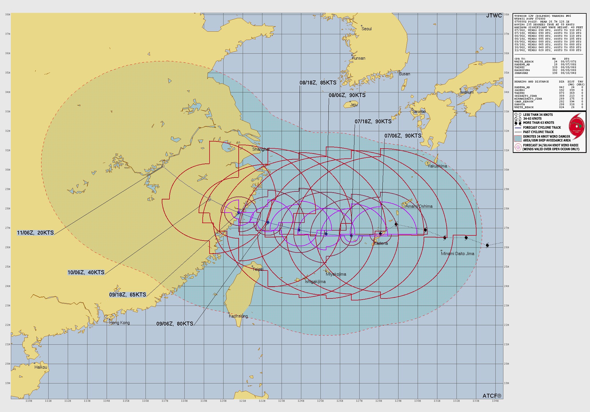
Latest official JTWC forecast track for Typhoon 12W (Dolphin), Warning No. 46, issued 7 August 2026. Source: Joint Typhoon Warning Center, US Navy.
Previous forecast cycle for comparison
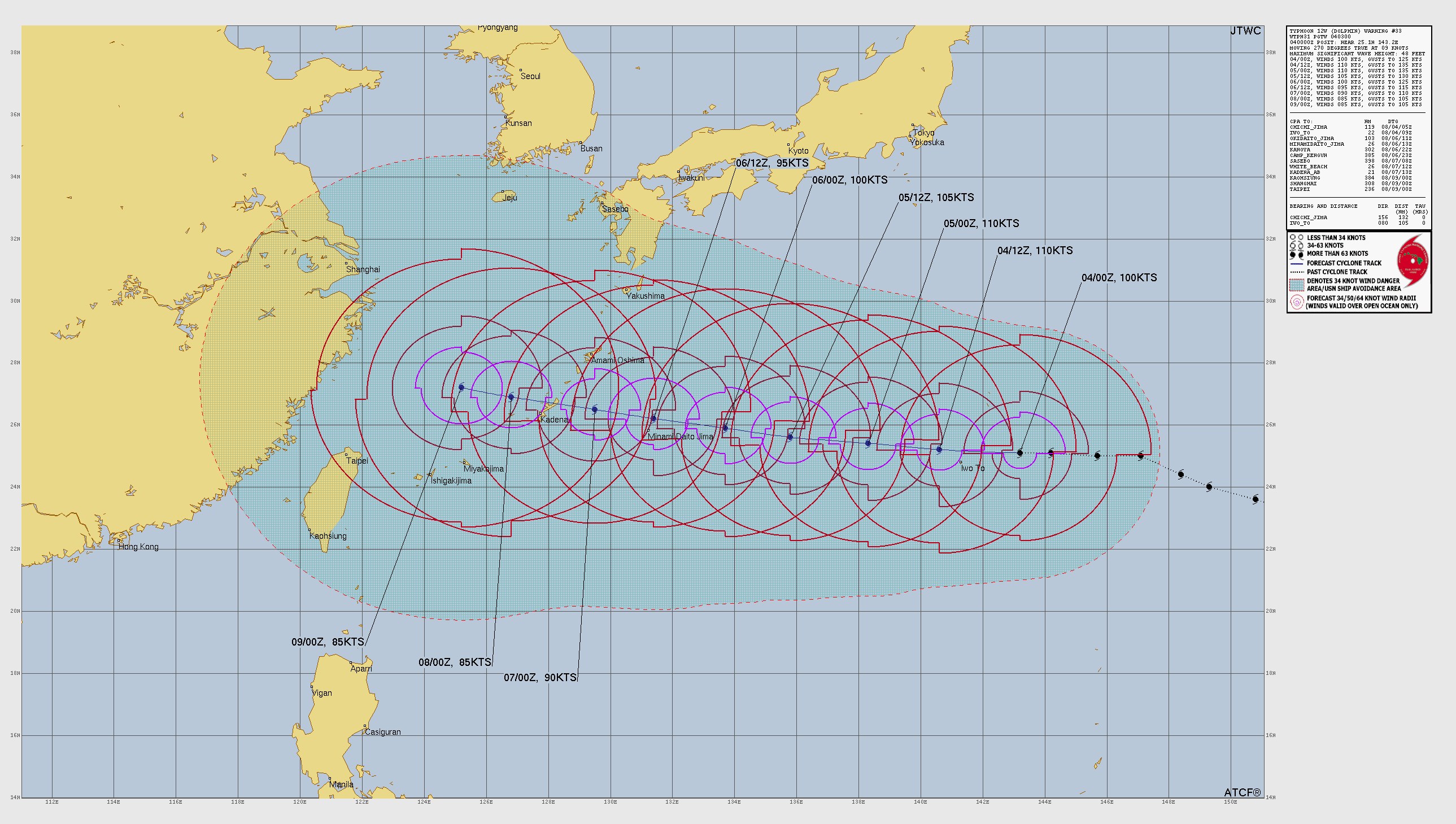
The earlier JTWC forecast track for Typhoon 12W (Dolphin), Warning No. 33, issued 4 August 2026, shown for comparison. Source: Joint Typhoon Warning Center, US Navy.
How Dolphin exploded in strength, then eased
Dolphin went from a weak tropical storm to a super typhoon in barely two days — a textbook case of what forecasters call rapid intensification. It has been sliding back down ever since. Here is the JTWC history:
27 July, 06:00 UTC: 35 kt — a modest tropical storm.
28 July, 06:00 UTC: 75 kt — typhoon strength, 24 hours later.
29 July, 18:00 UTC: 145 kt — its peak, briefly Category 5 equivalent.
30 July, 18:00 UTC: 135 kt — easing slightly, still super typhoon strength.
31 July, 18:00 UTC: 125 kt — downgraded from super typhoon by JTWC.
2 August: around 115 kt as the core went through internal reorganisation.
4 August, 00:00 UTC: 100 kt, central pressure 947 hPa.
5-6 August: holding near 95-100 kt as it closed on the Ryukyus.
7 August, 06:00 UTC: 90 kt, central pressure 951 hPa, alongside Okinawa.
In plain terms, Dolphin gained about 110 kt (200 km/h) of wind speed in 60 hours, then gave back roughly 55 kt over the following nine days. Very warm ocean water near 30°C, very little wind shear and excellent outflow aloft all lined up during the intensification phase. The steady decline since is typical of a mature typhoon moving over cooler water while its core repeatedly rebuilds — and it will now weaken faster as it interacts with land.
What JTWC forecasts over the next five days
Warning No. 46 holds Dolphin near its current strength for another day across the East China Sea, then weakens it quickly as it approaches the Chinese coast:
Later today, 7 August (12 hr): near 26.6°N 126.6°E — 90 kt (about 165 km/h), just west of Okinawa.
8 August (24 hr): near 26.7°N 125.3°E — 90 kt, tracking west at about 11 km/h.
8 August evening (36 hr): near 26.9°N 123.9°E — 85 kt (about 155 km/h).
9 August (48 hr): near 27.3°N 122.3°E — 80 kt (about 150 km/h), close to the coast of eastern China.
9 August evening (60 hr): near 27.8°N 120.8°E — 65 kt (about 120 km/h), weakening over land.
10 August (72 hr): near 28.5°N 119.3°E — 40 kt (about 75 km/h), described by JTWC as dissipating as a significant tropical cyclone over land.
11 August (96 hr): near 30.2°N 116.9°E — 20 kt, dissipated inland.
Two things stand out. First, the heading firms up at 270-310 degrees, so the whole remaining track is a run west then north-west into the East China Sea and eastern China. Second, the forward speed stays slow at about 6-7 kt (11-13 km/h). A slow-moving typhoon near land is the worst combination for rainfall totals, because the same areas sit under the rain bands for far longer.
Could Typhoon Dolphin hit Japan?
It already is affecting Japan — just not the mainland.
Okinawa and the Ryukyus are in the worst of it today. With the centre only about 37 km from Kadena at 06:00 UTC and hurricane-force winds extending 185 km to the north-east, Okinawa is seeing destructive wind gusts, huge swell and heavy rain through 7 August.
Mainland Japan is off the track. The forecast keeps Dolphin between about 26°N and 30°N and moves it west, away from Honshu, Shikoku and Kyushu.
Eastern China is now the main downstream risk. JTWC has Dolphin near the coast around 9 August at 80 kt and inland over the Zhejiang-Fujian region by 10 August, where it is expected to dissipate. That means heavy rain and flooding potential well inland even as the winds collapse.
Follow official warnings. The Japan Meteorological Agency (JMA) is the authority for Okinawa and the Ryukyus, and the China Meteorological Administration (CMA) for the mainland approach. Local evacuation and shelter instructions always take precedence over any forecast.
Weakening does not mean harmless. Typhoons usually grow larger as they weaken, spreading damaging wind, big swell and flooding rain across a wider area. Dolphin's gale-force wind field now extends about 490 km on its northern side.
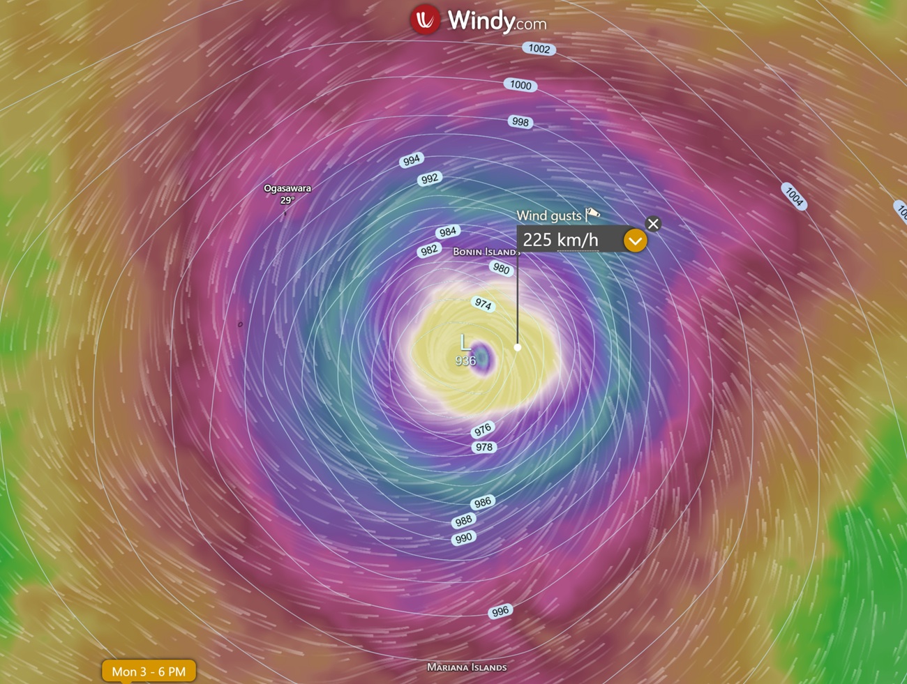
Windy.com map showing Typhoon Dolphin 2026's intense gusts and deep central pressure near the Bonin Islands, useful context alongside the official JTWC forecasts.
Threat to Taiwan and the Philippines
Dolphin stays north of both. It has not entered the Philippine Area of Responsibility (PAR), so PAGASA has not assigned a local Filipino name, and the remaining track runs north-west away from PAR. Northern Taiwan sits on the southern edge of the circulation as Dolphin crosses the East China Sea on 8-9 August, so squally winds, rough seas and rain bands are possible there even though the centre passes well to the north.
What has changed since our 4 August update
The Okinawa approach has arrived — the centre passed within about 37 km of Kadena Air Base at 06:00 UTC on 7 August, rather than being three days away.
Winds have eased from 100 kt to 90 kt, with central pressure now 951 hPa (from 947 hPa).
The storm has covered about 1,500 km, from 25.1°N 143.2°E to 26.7°N 128.1°E.
Eastern China has been added to the forecast track. JTWC now shows landfall near the Zhejiang-Fujian coast around 9-10 August and dissipation over land by 11 August — the previous cycle ended with Dolphin still at sea in the East China Sea.
The wind field has expanded again: gales now reach about 490 km north-east of the centre (up from 425 km).
Peak seas near the core have eased to about 12 metres, from 15 metres.
What to watch next
JTWC warnings: issued every six hours on 12W (Dolphin) at metoc.navy.mil/jtwc. The next bulletins are due at 15:00 and 21:00 UTC today, then 03:00 and 09:00 UTC on 8 August.
JMA advisories: official Japanese warnings and the five-day forecast circle from the Japan Meteorological Agency — the source that matters most for Okinawa and the Ryukyus.
Landfall timing and location in eastern China: a shift of even 100 km changes which provinces take the core winds and the heaviest rain.
Rainfall totals rather than wind: with a slow forward speed and land interaction, flooding rain becomes the dominant hazard from here.
Model agreement: whether ECMWF, GFS, UKMET and ICON stay locked on the East China Sea track or nudge the system north towards the Yellow Sea.
Sources
Joint Typhoon Warning Center (JTWC) — Typhoon 12W (Dolphin) Warning No. 46, issued 7 August 2026 09:00 UTC (warning position 06:00 UTC).
Joint Typhoon Warning Center (JTWC) — Warning No. 33, 4 August 2026 03:00 UTC (previous update in this article).
CIRA/RAMMB TC Real-Time — WP122026 best-track history and forecast track.
Japan Meteorological Agency (JMA) — Typhoon No. 13 (Dolphin) bulletins, 4-7 August 2026.
Related guides
- Madagascar drought update: Southern Madagascar crisis continues
- Philippines earthquake update 2026: magnitude 7.8 quake off Mindanao
- Typhoon Inday (International: Bavi / JTWC 09W) 2026 Update — Track, Intensity & PAGASA Naming
- Venezuela earthquake update: What is known so far after the magnitude 7.5 quake
Frequently asked questions
As at JTWC Warning No. 46 (09:00 UTC, 7 August 2026), Typhoon Dolphin (12W) was centred near 26.7°N 128.1°E — about 37 km (20 nautical miles) north-east of Kadena Air Base on Okinawa, so effectively on top of the island. Maximum sustained winds were 90 kt (about 165 km/h) gusting to 205 km/h, central pressure 951 hPa, moving south-west at 9 kt before turning back to the west.
Source: metoc.navy.mil
Planning weeks ahead?
Check Australia's long-range seasonal outlook for rainfall, temperature and the climate drivers (ENSO, IOD, SAM, MJO) shaping the next three months.
View Australia's Seasonal Weather Forecast