
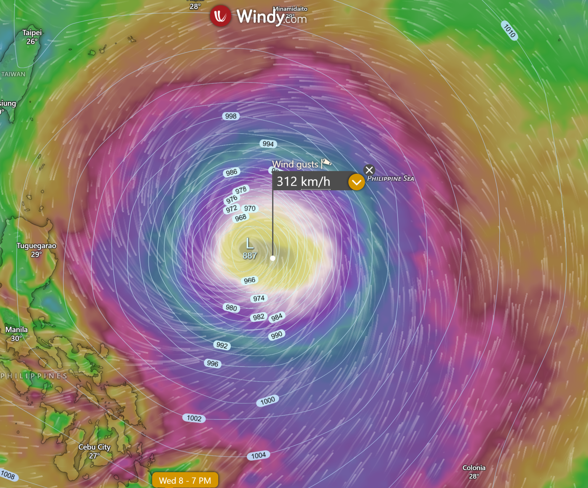
Update — 10 July 2026, 8:30 PM AEST (latest JTWC Warning No. 38, issued 10/0900 UTC): Typhoon Bavi has weakened sharply over the past 24 hours. Its eyewall replacement cycle stalled — a new outer ring of thunderstorms tried to form around the eye but never closed off, so the storm never got its inner core back together. Sustained winds are now 75 kt (139 km/h), gusts 90 kt (167 km/h), and central pressure has risen to 962 millibars. Bavi is now moving north-north-west at 12 kt (22 km/h), still very large but only Category 1-equivalent — well down from its Category 5 peak earlier in the week. JTWC now forecasts landfall on the Zhejiang coast (Yangtze River Delta area) of eastern China around 11–12 July, followed by rapid weakening over land.
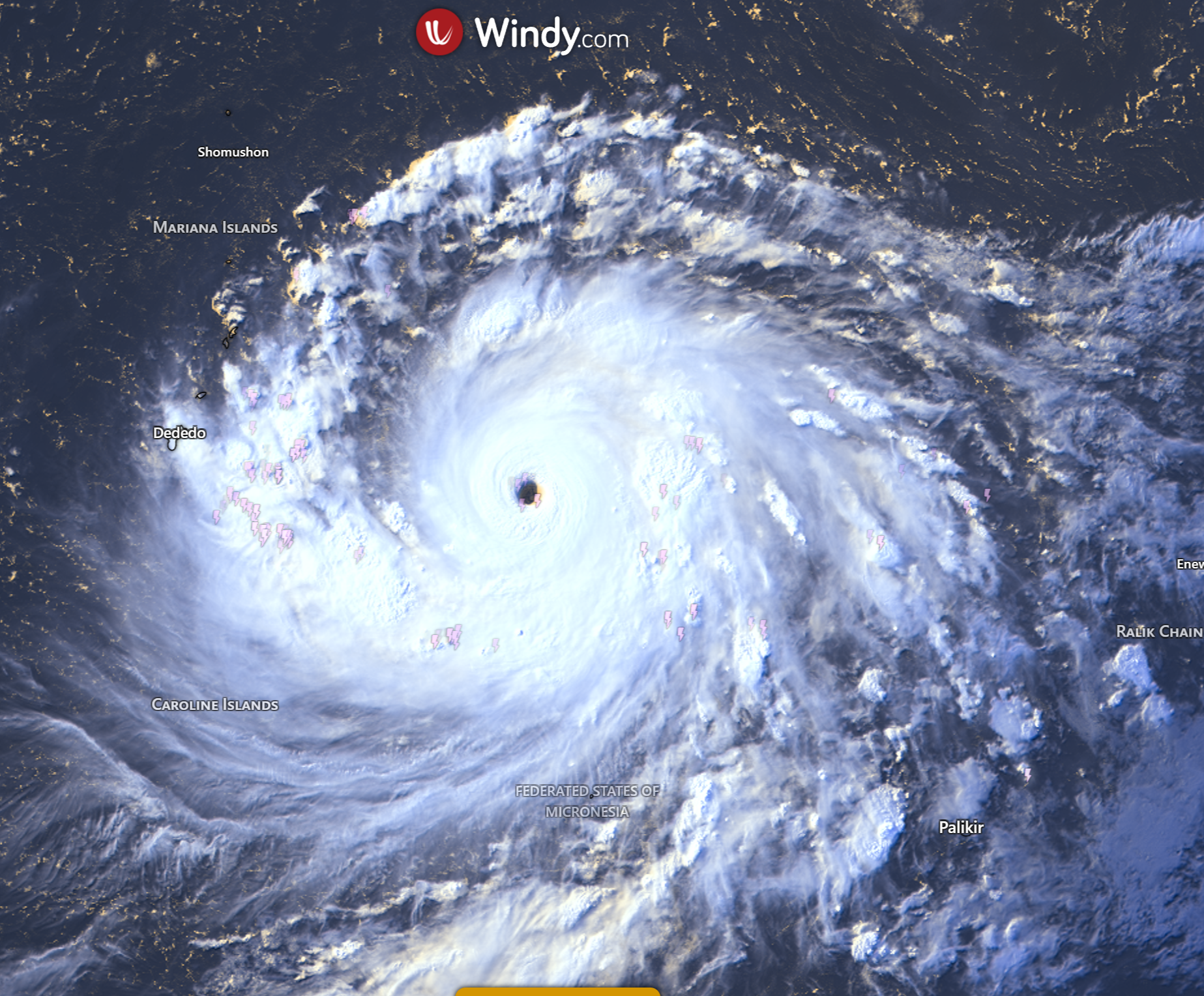
Satellite view of Typhoon Inday (Bavi) 2026, showing its powerful eye and cloud bands — crucial for tracking its intensity. Courtesy of www.windy.com
Bavi is centred near 22.4°N, 126.5°E — roughly 280 nautical miles (520 km) south of Kadena Air Base, Okinawa, moving north-north-west at 12 kt (22 km/h). The storm is now bearing down on the southern Ryukyu Islands (Yaeyama and Miyako chain), with the centre expected to pass close to those islands within 12–24 hours before curving west toward Taiwan's north coast and then on to eastern China.
Bavi has weakened to a Category 1-equivalent typhoon, but it is still a physically huge storm — gale-force winds and heavy rain reach out more than 500 km from the centre.
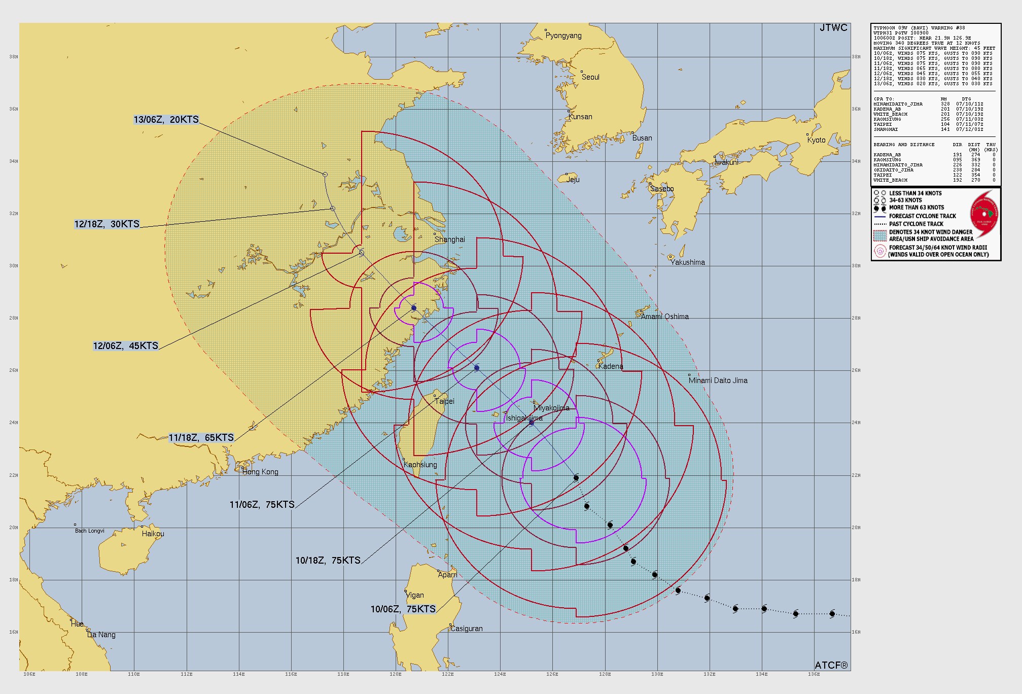
JTWC forecast track map for Typhoon 09W (Bavi / Inday) — Warning No. 38, issued 10/0900 UTC (10 July 2026, 7:00 PM AEST). Source: US Navy Joint Typhoon Warning Center (public domain).
Current status — Typhoon Bavi (09W)
From the latest JTWC bulletin (Warning No. 38, issued 10/0900 UTC — 10 July 2026, 7:00 PM AEST) and PAGASA Severe Weather Bulletin No. 12 (5:00 PM PHT, 10 July 2026):
Classification: Typhoon (JTWC 1-minute winds 75 kt — Category 1-equivalent, down from Category 5 earlier this week). PAGASA still classes it as a Typhoon.
International name: Bavi (assigned by the Japan Meteorological Agency).
PAGASA local name: Inday — assigned when the system entered the Philippine Area of Responsibility earlier in the week. PAGASA is issuing full Severe Weather Bulletins under this name.
Position (10/0900 UTC): 22.4°N, 126.5°E — about 280 nm (520 km) south of Kadena AB, Okinawa.
Maximum sustained winds: 75 kt (139 km/h), gusts 90 kt (167 km/h) — 1-minute average.
Central pressure: around 962 millibars (mb). Millibars measure the air pressure at the storm's centre — the lower the number, the stronger the storm. A rise from 940 to 962 mb in 24 hours confirms real weakening.
Movement: north-north-west at 12 kt (22 km/h), steered by a ridge of high pressure south of Honshu.
Maximum wave height: around 45 feet (14 m) near the core.
Storm size: still very large — gale-force winds (≥34 kt / 63 km/h) extend up to 340 nm (630 km) from the centre in the eastern half. This is why the Philippines, Taiwan and southern Japan are all feeling the storm at the same time.
Recent intensity trend: the eyewall replacement cycle has stalled. A concentric outer ring 170 nm wide never closed off on the north-west side, and cooler water dredged up from below the surface (called "upwelling") is starving the storm of energy. JTWC expects Bavi to hold roughly steady until landfall, then weaken rapidly over land.
Environment: low wind shear (5–10 kt) and sea temperatures of 27–29 °C are marginally favourable, but Bavi is too broad and disorganised to take advantage before landfall.
Observations already in: wind gusts approaching 50 kt (93 km/h) reported at Shimojishima and Okinawa (southern Japan).
Most likely track and intensity — next 5 days
JTWC keeps Bavi heading north-north-west across the southern Ryukyus, then curving west into the Taiwan Strait and making landfall on the eastern China coast. Model agreement is described as "tight" through the entire forecast period, with high confidence in the track for the next 72 hours.
JTWC forecast points (Warning No. 38)
+12 h (10/1800 UTC, 11 Jul 4:00 AM AEST): 24.0°N, 125.2°E — 75 kt (139 km/h), gusts 90 kt (167 km/h) — passing very close to the southern Ryukyu Islands.
+24 h (11/0600 UTC, 11 Jul 4:00 PM AEST): 26.1°N, 123.1°E — 75 kt (139 km/h), moving into the northern Taiwan Strait.
+36 h (11/1800 UTC, 12 Jul 4:00 AM AEST): 28.4°N, 120.7°E — 65 kt (120 km/h), dissipating over land as landfall occurs on the Zhejiang coast.
+48 h (12/0600 UTC, 12 Jul 4:00 PM AEST): 30.5°N, 118.7°E — 45 kt (83 km/h), inland over central China.
+60 h (12/1800 UTC, 13 Jul 4:00 AM AEST): 32.2°N, 117.6°E — 30 kt (56 km/h), weakening to a tropical depression.
+72 h (13/0600 UTC, 13 Jul 4:00 PM AEST): 33.5°N, 117.3°E — 20 kt (37 km/h), fully dissipated over land.
Why did the storm weaken so quickly? Three things worked against Bavi at once: the outer eyewall never closed the loop and never became a proper new eyewall (the "stalled ERC"); the storm's own churn pulled cooler water from below the surface, cutting off some of the warm-water fuel; and the circulation grew so wide that its energy was spread too thinly to concentrate into a strong core.
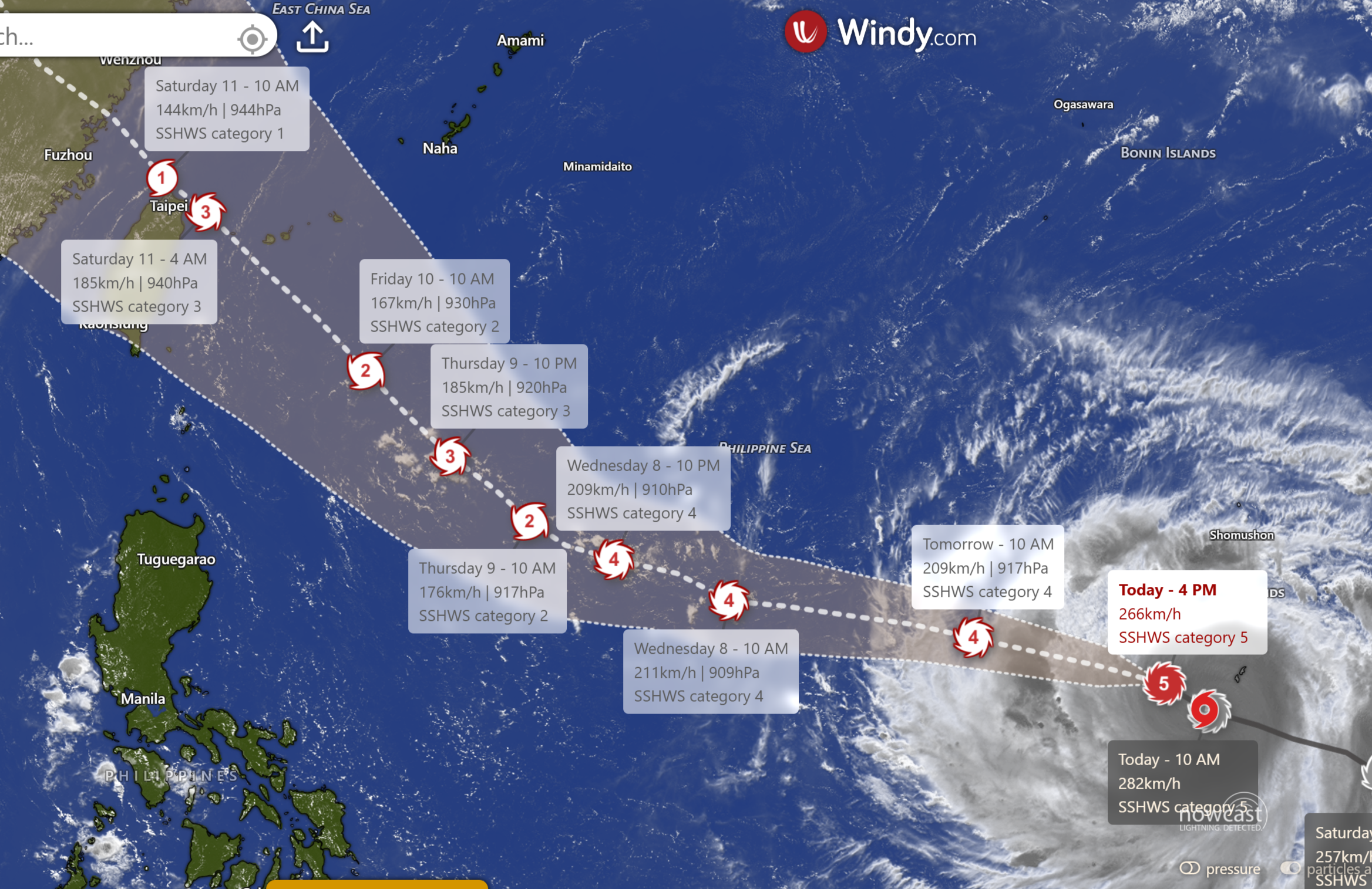
This forecast map visualises Typhoon Inday (Bavi) 2026's track and intensity, crucial for understanding its potential impact.
Expected impacts
Philippines — heavy rain and rough seas from the enhanced monsoon
Bavi is well north-east of Luzon and moving away, but its circulation is pulling the south-west monsoon (habagat) hard across the country. PAGASA Severe Weather Bulletin No. 12 (5:00 PM PHT, 10 July) puts:
Wind Signal No. 2 over Batanes, with Wind Signal No. 1 over the Babuyan Islands and parts of northern Cagayan.
Gale Warning in force over the northern and eastern seaboards of Northern Luzon and the eastern seaboard of Central Luzon.
Very rough to high seas: waves up to 7 metres off Batanes, 6 m off the Babuyan Islands and northern Cagayan, 5 m off mainland Cagayan and 4.5 m off Isabela and northern Aurora. PAGASA warns sea travel is risky for all vessel sizes.
Heavy rainfall across most of the country from the enhanced habagat today and tomorrow (11 July), then focusing on Luzon, Visayas and parts of northern Mindanao on 12 July. Flash flooding and landslides are the main risks.
Southern Ryukyu Islands (Japan) — main threat in the next 12–24 hours
The centre of Bavi will pass very close to the Yaeyama and Miyako chain (Ishigakijima, Miyakojima) within 24 hours. Expect:
Damaging winds with gusts to 90 kt (167 km/h) near the eyewall.
Very heavy rain and localised flooding.
Dangerous storm surge and waves along south- and east-facing coasts.
The JMA has typhoon warnings and heavy rain advisories in place for the region — residents should follow local instructions and be indoors well before the eye arrives.
Taiwan and eastern China — main landfall threat 11–12 July
After the Ryukyus, Bavi will cross the northern Taiwan Strait and make landfall on the Zhejiang coast (around the Yangtze River Delta) on 11–12 July. Because the wind field is so broad, impacts will begin well before the eye arrives:
Damaging winds along the northern Taiwan and Zhejiang/Fujian coastline.
Widespread storm surge along east-facing coasts — Bavi's huge circulation will push a broad surge onshore even as the core weakens.
Torrential rainfall (200–400+ mm in favoured spots) across northern Taiwan, coastal Zhejiang and southern Jiangsu, with a high risk of urban flooding and landslides.
Dangerous seas across the East China Sea disrupting shipping — significant wave heights near the core are estimated at 45 ft (14 m).
Even after Bavi dissipates over land, JTWC warns a broad fetch of strong winds will keep blowing across offshore China and into the Yellow Sea for a day or more afterwards.
How this system got its two names
Every typhoon in the Western Pacific carries two names at once:
An international name — assigned by the WMO Typhoon Committee through JMA in Tokyo. This one is Bavi, a name contributed by Vietnam.
A Philippine local name — assigned by PAGASA the moment a storm enters the Philippine Area of Responsibility, regardless of whether it already has an international name.
PAGASA uses a rotating list of Filipino names, cycled every four years. On the 2026 list, Inday was the next name in sequence after Henry. Because Bavi crossed into the PAR earlier this week, PAGASA is now issuing bulletins under the name Inday.
Also in the basin
Bavi is currently the only active tropical cyclone in the Northwest Pacific being tracked by JTWC. Two areas of interest — Invest 90C and Invest 97W — are being monitored elsewhere in the basin but have not yet developed.
Why Bavi is still such a big storm even after weakening
Very large wind field — gale-force winds reach out about 310–340 nm (575–630 km) from the centre, and storm-force winds up to 200 nm (370 km). That is why coastal impacts spread so wide.
Massive wave energy — 45 ft (14 m) seas near the core.
Slow forward speed (~22 km/h) — enough that any location the eye passes over gets pounded for many hours, not minutes.
What is a Category 5 typhoon?
A Category 5 tropical cyclone on the Saffir–Simpson Hurricane Wind Scale has 1-minute sustained winds of at least 137 kt (252 km/h / 157 mph). Bavi peaked well inside this category earlier in the week; it is now sitting in Category 1 (64–82 kt / 119–152 km/h) after a stalled eyewall replacement and cool-water upwelling. In the Western Pacific, the equivalent JMA classification at peak was Violent Typhoon — it is now simply a Typhoon.
What's changed since the last update (24 hours)
Bavi has weakened from 115 kt to 75 kt (213 → 139 km/h) — a drop of about 75 km/h in a day.
Central pressure has risen from 940 mb to 962 mb.
The eyewall replacement cycle stalled and never completed. Cooler subsurface water and the storm's own huge size prevented re-intensification.
The track has turned more sharply northward — Bavi is now moving north-north-west at 12 kt (22 km/h).
Position is now 22.4°N, 126.5°E — about 280 nm (520 km) south of Okinawa, roughly 500 km closer to Japan than yesterday.
Landfall has been brought forward to 11–12 July on the Zhejiang coast (Yangtze River Delta), further north than previously forecast.
PAGASA is now issuing Severe Weather Bulletin No. 12 for Typhoon "Inday", with Wind Signal No. 2 over Batanes and 7 m seas offshore.
Australian relevance
Bavi is a Northern Hemisphere system and sits well outside the Australian tropical cyclone area of responsibility (90°E–160°E, south of the equator). There are no direct impacts expected for Australia. For Australian readers, Bavi is a useful case study in how eyewall replacement cycles and cool-water upwelling can bring even a Category 5 typhoon down very quickly — and how AI models (Google DeepMind's GraphCast and GenCast) and the ECMWF handled the intensity swings.
Forecast may still change
Intensity carries meaningful uncertainty near landfall, and the exact landfall point along the south-east China coast could still shift by 50–100 km either way. Residents across the southern Ryukyus, northern Taiwan, coastal eastern China and the northern Philippines should follow official bulletins from JTWC, JMA, PAGASA and the Taiwan Central Weather Administration.
Key points
Typhoon Bavi (JTWC 09W / PAGASA: Inday) — now 75 kt / 139 km/h, gusts 90 kt / 167 km/h, pressure ~962 mb.
Positioned 22.4°N, 126.5°E — about 280 nm (520 km) south of Okinawa, moving north-north-west at 12 kt (22 km/h).
Weakened from Category 5 to Category 1 after a stalled eyewall replacement cycle and cool-water upwelling.
Still a physically huge storm — gale-force winds reach 630 km from the centre.
Track brings the centre near the southern Ryukyus in the next 12–24 hours, then landfall on the Zhejiang coast (Yangtze River Delta) around 11–12 July.
PAGASA has Wind Signal No. 2 over Batanes and gale warnings for northern Luzon; enhanced habagat is bringing heavy rain across most of the Philippines.
No Australian impact.
Sources
JTWC — Typhoon 09W (Bavi) Warning No. 38 (WTPN31 PGTW 100900, 10 July 2026 09:00 UTC)
JTWC — Prognostic Reasoning for Typhoon 09W (Bavi), Warning No. 38
Last verified: 10 July 2026, 8:30 PM AEST (JTWC Warning No. 38, issued 10/0900 UTC; PAGASA Severe Weather Bulletin No. 12, 5:00 PM PHT).
Related guides
Frequently asked questions
Bavi is currently moving west-northwest across the western Pacific. It is forecast to pass near Guam and the Northern Mariana Islands before potentially turning poleward later next week. However, the exact path remains uncertain, so residents and travellers should monitor updates as the steering patterns fluctuate.
Source: nminewsservice.com
Further reading and resources
Explore trusted articles, books, videos and other resources to go deeper on this topic.
nminewsservice.comArticle
Storm Named Bavi; JTWC: Super Typhoon Impact Within 96 Hours
Provides a localized analysis of the threat Bavi poses to the Mariana Islands as it rapidly intensifies.
storm2k.orgArticle
WPAC: 09W - Tropical Depression - Discussion
In-depth community discussion and early tracking observations reflecting the storm's transition from an Invest.
rammb-data.cira.colostate.eduReference
WP032015 - Tropical Storm BAVI - RAMMB: TC Real-Time
Storm Synopsis Satellite Model Data Wind Hazards Experimental. Forecast Track. Time of Latest Forecast: 2015-03-21 18:00. Forecast Hour, Latitude, Longitude ...
Planning weeks ahead?
Check Australia's long-range seasonal outlook for rainfall, temperature and the climate drivers (ENSO, IOD, SAM, MJO) shaping the next three months.
View Australia's Seasonal Weather Forecast