
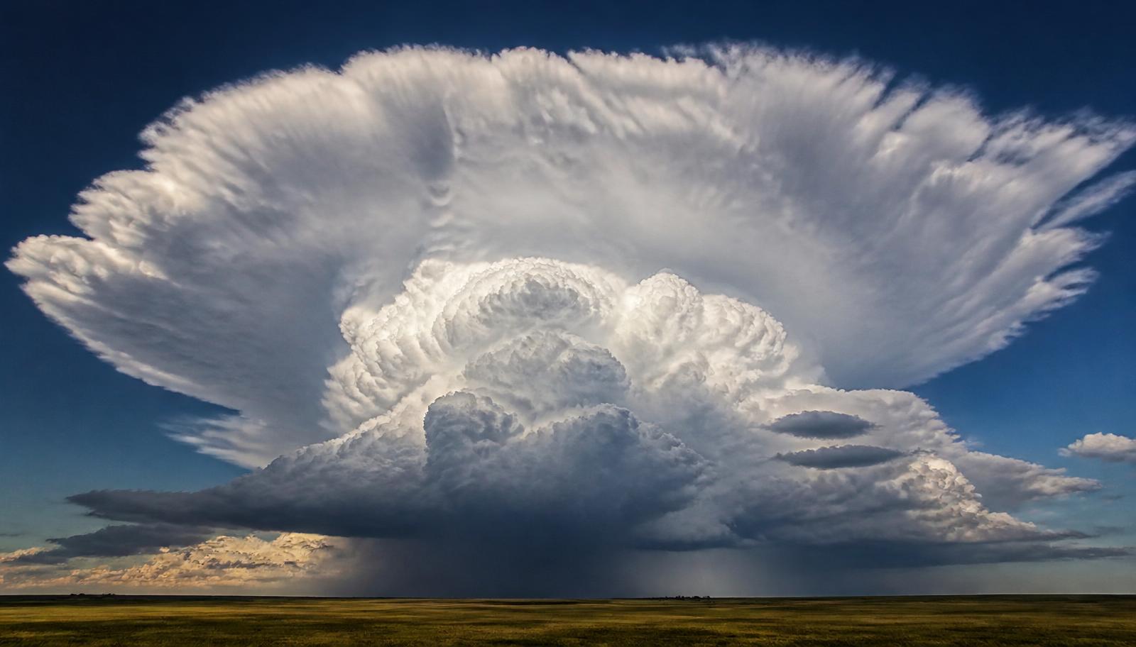
When asking how do cumulonimbus clouds form, the short answer is deep moist convection. Warm, humid air rises into a conditionally unstable atmosphere, cools as it expands, and reaches the dew point. Water vapour then condenses, latent heat is released, and the updraft can keep building the cloud toward the tropopause.
Key takeaways
Cumulonimbus clouds need moisture, atmospheric instability and a lifting trigger to get started.
Solar radiation, sea breeze fronts and cold fronts can all help air rise and begin storm growth.
Updrafts exceeding 161 km/h explain a thunderstorm's rapid growth and why aircraft generally avoid flying through them.
The tropopause caps the cloud top, which is why many storms spread into an anvil top.
Strong vertical wind shear can help organise storms into supercells, which are among the most severe thunderstorm types.
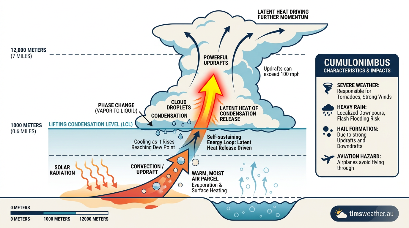
Infographic showing how cumulonimbus clouds form through rising moisture and condensation.
How do cumulonimbus clouds form?
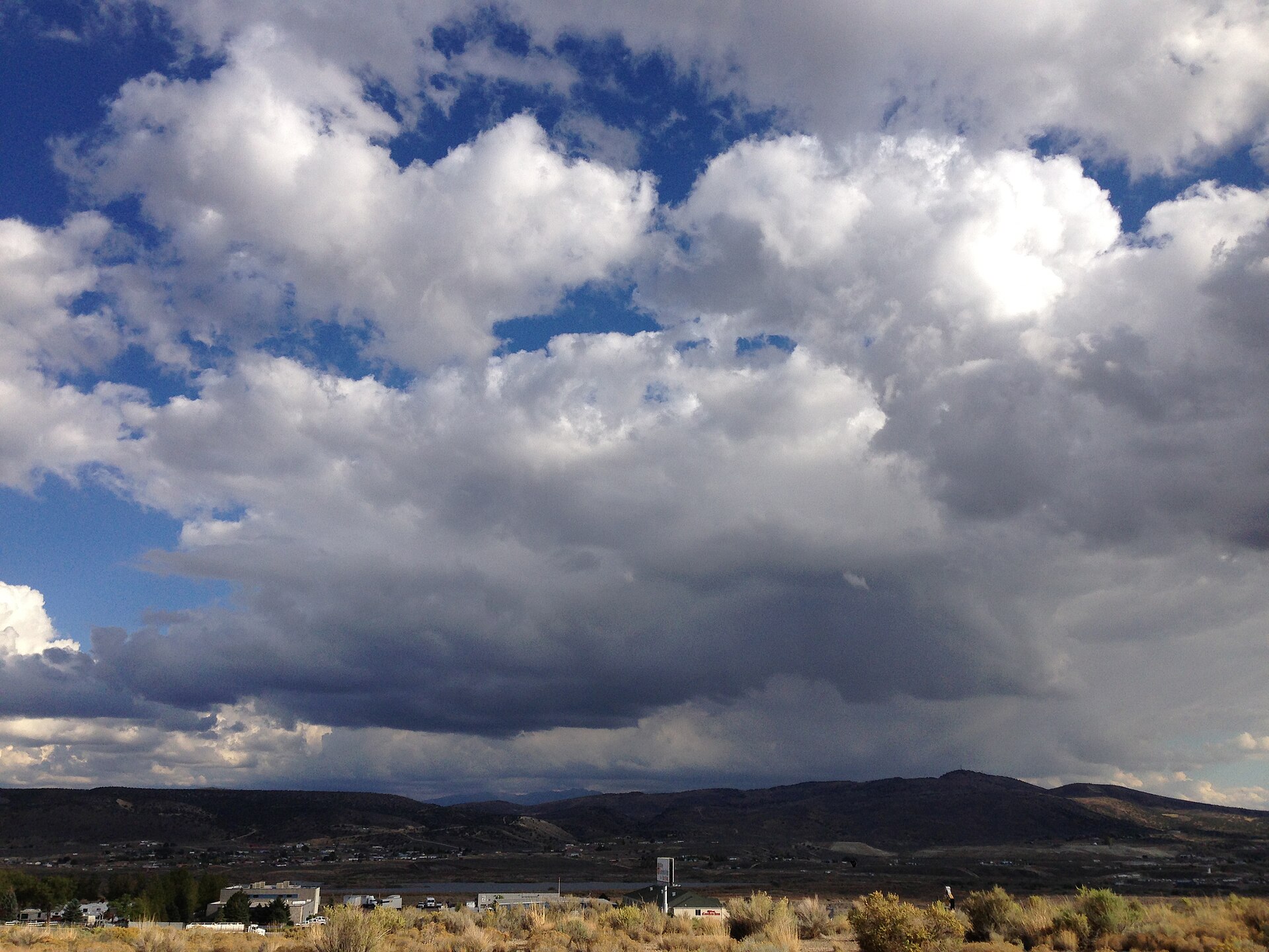
2014-09-30 16 00 25 Cumulus clouds developing southeast of Elko, Nevada Image: “2014-09-30 16 00 25 Cumulus clouds developing southeast of Elko, Nevada” by Famartin, via Wikimedia Commons (CC BY-SA 4.0).
Cumulonimbus clouds form when warm, moist air is forced upward fast enough for deep moist convection to take over. The Bureau of Meteorology (BOM) uses that same basic recipe in thunderstorm forecasting: moisture, lift and instability. If those ingredients line up, small cumulus clouds can build into towering storm clouds.
EarthSky notes that cumulonimbus clouds can start near 1,000 metres and rise to about 12,000 metres, which gives them the vertical scale needed for thunder, heavy rain, hail and lightning. That height range also shows why these clouds matter for Australian storm warnings.
Why deep moist convection matters
Deep moist convection is the process that builds the cloud vertically. Near the ground, warm air is less dense than the air above it, so it rises. If the air stays warmer than its surroundings after lifting, the upward motion continues and the cloud grows taller.
This is where atmospheric instability comes in. In an unstable atmosphere, the rising parcel remains buoyant. In a stable atmosphere, it slows down and stops. BOM forecasters watch that balance closely because it helps explain whether a shower stays shallow or becomes a thunderstorm.
Solar radiation and the first lift
Solar radiation is one common starting point. Sunlight warms the land surface, and the ground then warms the air above it. That is why storm days often get more active through the afternoon, once the boundary layer has had time to heat and mix.
Moisture also matters. Water vapour in the lower atmosphere feeds the cloud base once rising air starts to cool. A higher dew point means the air is already close to saturation, so it takes less cooling for condensation to begin.
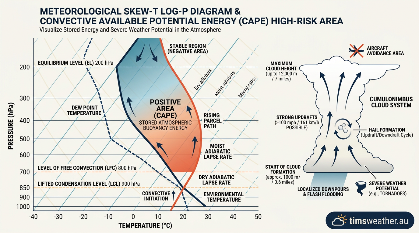
Skew-T log-P chart showing atmospheric instability during storm formation.
How does adiabatic cooling build the cloud?
As air rises, pressure falls with height, so the parcel expands and cools. That cooling without heat exchange with the surroundings is called adiabatic cooling. It is one of the key steps in cloud formation, because rising air must cool to its dew point before cloud droplets can form.
Once the air reaches saturation, water vapour condenses into tiny liquid droplets. That condensation releases latent heat, which slows the cooling of the parcel. The parcel then stays warmer than the surrounding air for longer, so the updraft can keep rising.
This feedback is the engine of a storm cloud. More lift leads to more cooling, more condensation and more latent heat release. In a strong storm, that cycle can repeat many times, helping the cloud deepen quickly.
What does the tropopause do?
The tropopause is the stable layer near the top of the troposphere. It acts like a lid on most thunderstorm growth. When a cumulonimbus tower reaches that layer, the updraft can no longer keep rising straight up, so the cloud spreads sideways.
That sideways spread creates the anvil top. In Australian storm morphology, the tropopause matters because it helps shape how high storms can build and how their tops flatten or spread. Warmer air and a higher tropopause can allow taller storms, while a lower tropopause can make the anvil form sooner.
What triggers cumulonimbus clouds in Australia?
A trigger is the final push that lifts surface air into the storm-building layer. Without that lift, even moist air may stay near the ground. In Australia, the BOM often sees several common triggers working on the same day.
Sea breeze fronts, where cooler marine air pushes inland and forces warm air up.
Cold fronts, which undercut warm air and lift it along the boundary.
Terrain, where hills and ranges force air upward.
Convergence lines, where winds meet and pile air upward.
Sea breeze fronts are especially important along the coast. In the afternoon, a sea breeze can move inland and focus new updrafts. If the air inland is hot and humid enough, that boundary can trigger cumulonimbus development well away from the shoreline.
This is a common setup in eastern Australia. The inland air heats through the day, then the sea breeze arrives and provides the lift. The result can be a line of storms that form inland rather than right on the coast.
The role of vertical wind shear
Vertical wind shear is the change in wind speed or direction with height. It does not create a thunderstorm on its own, but it can change the storm’s structure once it forms. Strong shear helps separate the updraft from the rain core, which allows the storm to last longer.
That matters for supercells. Supercells are organised thunderstorms with a rotating updraft, and they are more likely when instability and shear occur together. Not every cumulonimbus cloud becomes a supercell, but when shear is strong enough, the storm can become much more severe.
How do cumulonimbus clouds form in stages?
Cumulonimbus clouds usually develop through three broad stages: cumulus, mature and dissipating. The stages help explain why the cloud looks calm at first, then suddenly turns active.
Stage | What is happening | What you may see |
|---|---|---|
Cumulus stage | Updrafts dominate and the cloud grows vertically. | A puffy tower with a flat base. |
Mature stage | Updrafts and downdrafts both operate. | Heavy rain, lightning, hailstones and an anvil top. |
Dissipating stage | Downdrafts cut off the warm inflow. | Rain weakens and the cloud loses depth. |
EarthSky notes that cumulonimbus clouds can produce severe weather, including heavy rain, hail and tornadoes. In Australia, they are also a common source of damaging wind gusts and localised downpours.
How hailstones form inside a storm cloud
Hailstones form when strong updrafts carry water droplets high into cold parts of the cloud, where they freeze and grow in layers. As the hail is lifted and dropped through the cloud, it can collect more ice and water. Once it becomes too heavy for the updraft, it falls to the ground.
That process needs a strong storm. Weak showers rarely make hail because the updrafts are not powerful enough to keep ice particles suspended for long.
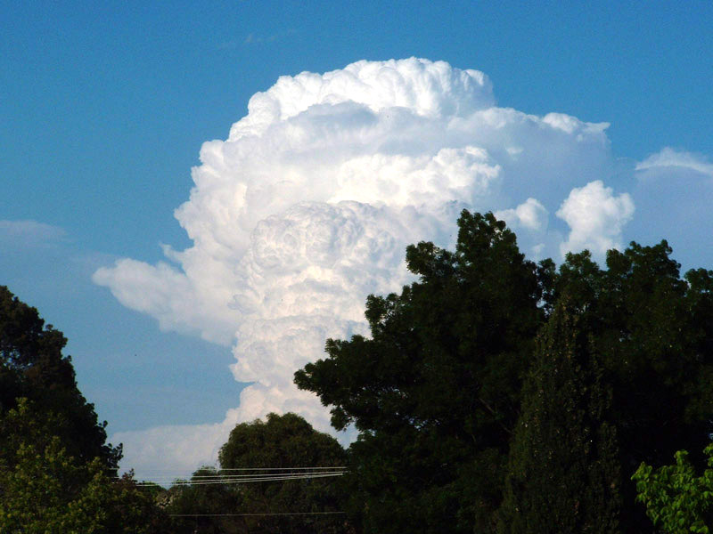
Cumulonimbus calvus - By Photo taken by Bidgee - User:Bidgee's Own work, CC BY-SA 2.5, https://commons.wikimedia.org/w/index.php?curid=832919
How strong can cumulonimbus updrafts get?
Very strong. EarthSky says updrafts in cumulonimbus clouds can exceed 161 km/h. Those winds help explain why these clouds can build so quickly and why aircraft generally avoid flying through them.
Strong updrafts also help maintain the storm’s internal structure. If the rising air is fast enough, it can keep feeding the cloud top while rain and hail fall through the downdraft on the other side.
Why does the cloud top spread into an anvil?
The anvil top forms when rising air reaches the tropopause and spreads out horizontally. The air near that layer is much more stable, so the cloud cannot grow much taller. Instead, ice crystals are carried sideways by the upper-level winds, which gives the storm its flattened top.
That anvil can extend downwind of the storm core, so the visible top is not always sitting directly over the strongest rain or lightning. If you are watching a storm from a distance, the anvil is a good sign that the cloud has reached its upper limit.
What severe weather can cumulonimbus clouds cause?
Cumulonimbus clouds are the main thunderstorm cloud, so they can produce a wide range of severe weather. The exact mix depends on moisture, instability, wind shear and the strength of the updrafts.
Heavy rain and localised flash flooding.
Lightning.
Hailstones, sometimes large enough to damage property.
Damaging wind gusts and downbursts.
Tornadoes in the most organised storms.
If you are in an area under a BOM thunderstorm warning, keep an eye on the warning text and update your plans early. Move indoors, secure loose items, and stay away from trees and powerlines during severe wind gusts.
How do BOM forecasters read the atmosphere?
BOM forecasters look at temperature, dew point, wind and vertical structure to judge whether thunderstorms may form. Skew-T log-P charts help show where the atmosphere is unstable, where moisture sits, and whether a lid or inversion may stop storm growth. Those charts are one reason storm forecasts can be so specific about timing and location.
Forecasters also compare surface heating with wind shear and the expected trigger. A hot inland airmass, a moist sea breeze and strong upper-level winds can be enough to produce a line of storms. On other days, the ingredients are there but the lift never arrives, so the sky stays partly cloudy instead.
How do cumulonimbus clouds form? The short answer for Australia
In Australia, cumulonimbus clouds usually form when solar heating, moist air and a lifting trigger work together. The air cools as it rises, condensation begins at the dew point, latent heat powers the updrafts, and the cloud keeps growing until it meets the tropopause. If vertical wind shear is strong enough, the storm may organise into a supercell and produce severe weather.
That is the basic pattern behind many summer thunderstorms from the coast to inland districts. Watch for sea breeze fronts near the coast, cold fronts in the south, and hot, humid afternoons anywhere the atmosphere is primed for convection.
Related guides
Frequently asked questions
Cumulonimbus clouds form when warm, moist air is lifted into cooler air and keeps rising in an unstable atmosphere. The rising air cools, causing water vapour to condense into droplets. As this process continues, the cloud grows vertically into a towering structure that often leads to thunderstorms.
Source: bom.gov.au
Further reading and resources
Explore trusted articles, books, videos and other resources to go deeper on this topic.
weather.govReference
Cloud Classification
Background reference on How do cumulonimbus clouds form? Stages, triggers and severe weather impacts from weather.gov.
earthsky.orgArticle
Cumulonimbus clouds bring thunderstorms: How to spot them
In-depth coverage on How do cumulonimbus clouds form? Stages, triggers and severe weather impacts from earthsky.org.
youtube.comVideo
Formation Stages & Aviation Hazards (CPL/ATPL)
Video coverage on How do cumulonimbus clouds form? Stages, triggers and severe weather impacts from youtube.com.
en.wikipedia.orgReference
Cumulonimbus cloud
Background reference on How do cumulonimbus clouds form? Stages, triggers and severe weather impacts from en.wikipedia.org.
rams.atmos.colostate.eduReference
Part 7. Conceptual Models of Cumulonimbi
Background reference on How do cumulonimbus clouds form? Stages, triggers and severe weather impacts from rams.atmos.colostate.edu.
stormhour.comArticle
StormHour Guide to Cumulonimbus Clouds
In-depth coverage on How do cumulonimbus clouds form? Stages, triggers and severe weather impacts from stormhour.com.
noaa.govReference
Life Cycle of a Thunderstorm
Background reference on How do cumulonimbus clouds form? Stages, triggers and severe weather impacts from noaa.gov.
britannica.comReference
Science of cumulonimbus formation explained
Background reference on How do cumulonimbus clouds form? Stages, triggers and severe weather impacts from britannica.com.
skybrary.aeroArticle
Lifecycle of the Thunderstorm
In-depth coverage on How do cumulonimbus clouds form? Stages, triggers and severe weather impacts from skybrary.aero.
scied.ucar.eduReference
How Thunderstorms Form - UCAR Center for Science Education
Background reference on How do cumulonimbus clouds form? Stages, triggers and severe weather impacts from scied.ucar.edu.
Planning weeks ahead?
Check Australia's long-range seasonal outlook for rainfall, temperature and the climate drivers (ENSO, IOD, SAM, MJO) shaping the next three months.
View Australia's Seasonal Weather Forecast