

Roll cloud formation occurs when cool outflow air from a storm, or a strong sea breeze boundary, pushes under warm, moist air and lifts it. That rising air cools and condenses into a long, horizontal cloud band. If the lower atmosphere has a stable inversion, the cloud can keep its tube shape and appear detached from the parent storm.
Key takeaways
- Roll clouds are a form of arcus cloud, but the World Meteorological Organization classifies them as the species *volutus*; when associated with stratocumulus, the correct form is *Stratocumulus volutus*.
- They form along gust fronts, outflow boundaries, cold fronts, and sea breeze convergence lines when cool air undercuts warm, moist air.
- Wind shear and a low-level temperature inversion help keep the cloud long and level.
- Morning Glory cloud over the Gulf of Carpentaria is a well-known example of a long roll cloud event in Australia.
- Roll clouds are usually harmless on their own, but they can mark a sharp wind change and rough air near the boundary.
What is a roll cloud?
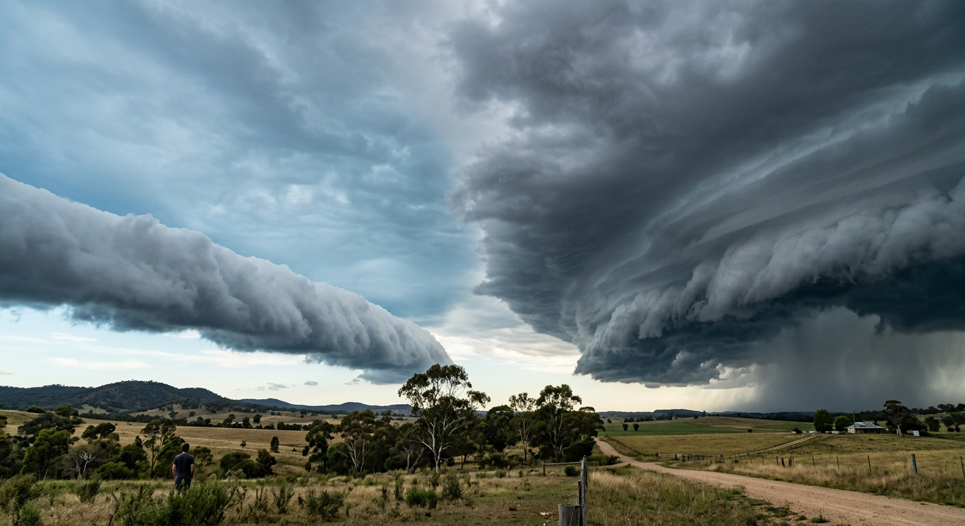
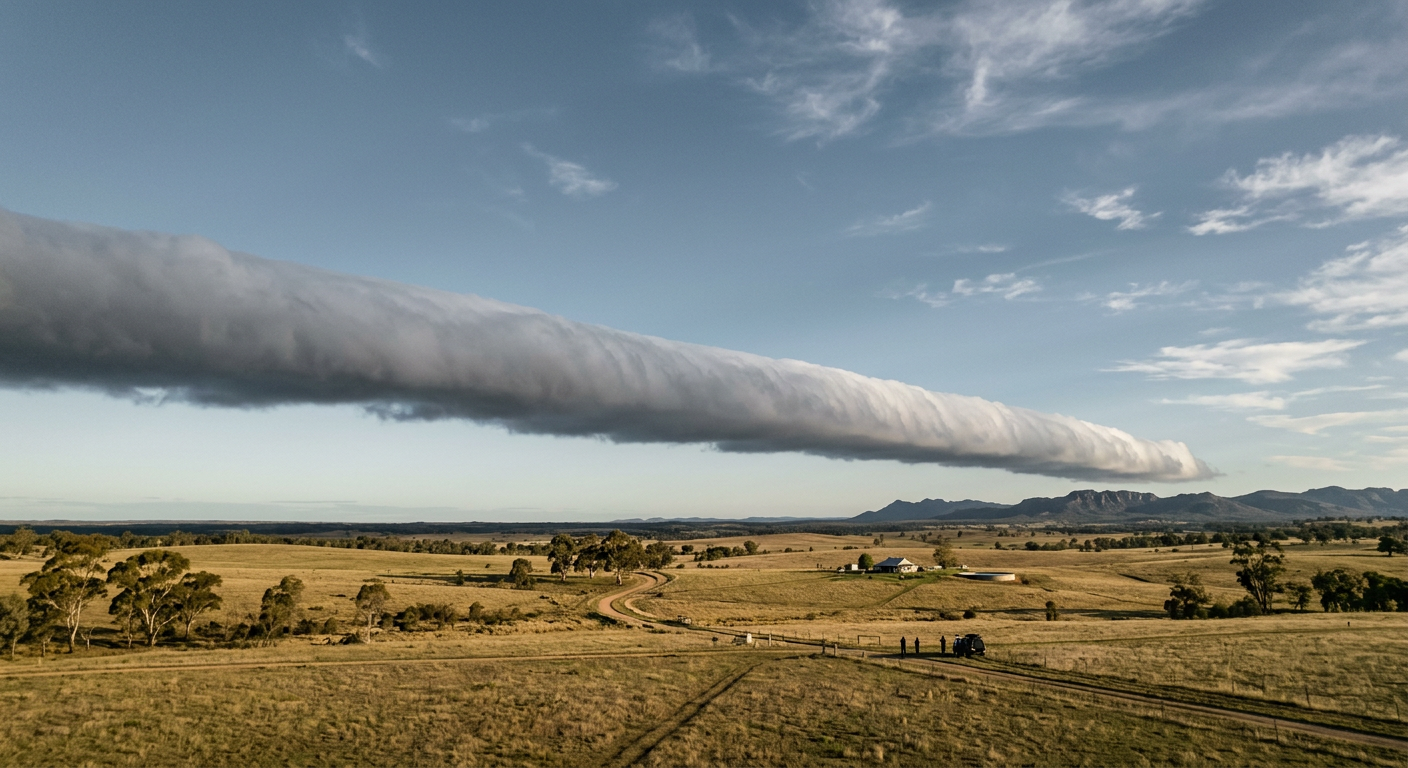
A roll cloud is a low, horizontal cloud that looks like a tube or long cylinder. It usually forms along the leading edge of a weather boundary, such as a gust front, an outflow boundary, a cold front, or a strong sea breeze convergence line. The cloud can look isolated, but it is really tied to lifting along that moving boundary.
These clouds sit in the arcus cloud family. The key feature is separation from the storm cloud above or behind it. A shelf cloud stays attached to the storm base, while a roll cloud sits lower and appears detached. That difference matters if you are trying to read the sky before a wind change.
The Bureau of Meteorology uses terms like gust front, outflow boundary and squall line when describing severe weather boundaries. If you are watching the sky near a thunderstorm, a roll cloud often means the leading edge of that cooler air is arriving first.
Volutus and the cloud classification
The World Meteorological Organization recognises volutus as the species name for the rolled, tube-like form. In practice, you will often see the term written as stratocumulus volutus. You can read more in our guide to the stratocumulus volutus cloud.
This label helps separate roll clouds from shelf clouds and other arcus forms. It also gives spotters and forecasters a cleaner way to describe what they are seeing along a boundary.
How roll cloud formation works
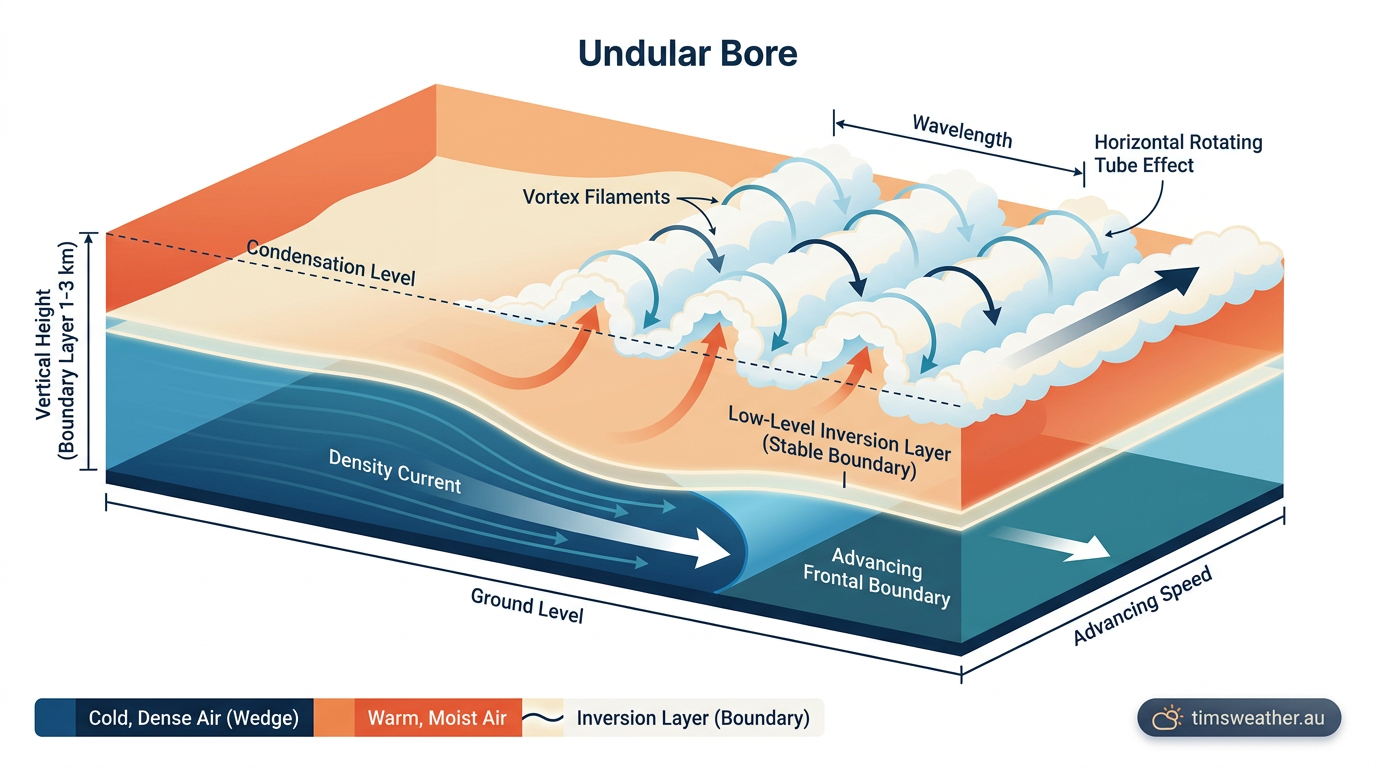
Roll cloud formation starts when colder, denser air spreads out near the ground and lifts warmer air ahead of it. That cooler air often comes from thunderstorm downdraft air that hits the surface and fans outward as an outflow boundary or gust front. It can also come from a strong sea breeze convergence line or a cold front.
As the warm air rises, it cools to its dew point and water vapour condenses into cloud. If the lift stays smooth and organised, the cloud grows into a long tube rather than a broken patch. That is why roll clouds often look neat and level, even while the air beneath them is changing fast.
Why wind shear matters
Wind shear is a change in wind speed or wind direction with height. In a roll cloud, shear helps keep the lifted air spinning along a horizontal axis instead of turning into a tall tower. That is part of why the cloud can hold its shape for so long.
Shear also helps explain why a roll cloud can stretch across a large area. Different layers of air move at different speeds, so the lifting boundary does not stay in one place. The cloud is constantly renewed where the air is rising and condensing.
For readers learning how storms organise themselves, our guide to how thunderstorms form explains the role of downdrafts and surface boundaries.
What the inversion does
A low-level temperature inversion is a layer where temperature rises with height for a short distance instead of falling. That stable layer acts like a lid. It limits vertical mixing and encourages the rising air to spread sideways, which can help create a roll cloud or an undular bore.
An undular bore is a wave-like disturbance that moves through a stable layer, much like ripples travelling across calm water. When that wave lifts moist air to its condensation point, a line of clouds can form. In the right setup, the cloud line appears smooth and rolling, while the air below may be turbulent.
Outflow boundary, gust front and solitary wave
Many roll clouds form on the leading edge of storm outflow. The outflow boundary marks where the cooler storm air pushes into warmer surrounding air. The gust front is the sharp edge of that boundary at the surface, and it often brings a sudden wind shift.
Sometimes the cloud line is linked to a solitary wave, also called a gravity wave, that travels through the stable air ahead of the storm. If the wave stays organised, it can produce a smooth, rolling cloud band. If the lift is weaker, the cloud may fade quickly or break into patches of stratocumulus.
Roll clouds, shelf clouds and Morning Glory cloud
Roll clouds and shelf clouds can look similar, but they are not the same. A shelf cloud is attached to the storm base and often marks the edge of a strong thunderstorm gust front. A roll cloud is detached, lower and more isolated. That is the quickest way to tell them apart.
| Feature | Roll cloud | Shelf cloud |
|---|---|---|
| Attachment | Detached from the storm base | Attached to the storm base |
| Shape | Long, horizontal tube | Wide wedge or shelf |
| Common trigger | Outflow boundary, sea breeze convergence, solitary wave | Thunderstorm gust front |
| What it signals | Sharp boundary and wind shift | Rain core and stronger storm edge nearby |
The Morning Glory cloud in the Gulf of Carpentaria is the best-known Australian example of a long roll cloud or roll-cloud-like wave cloud. It can form in the early morning when the atmosphere sets up a strong, stable layer over the gulf. Burketown is a common reference point for people who travel there to see it, especially during the right seasonal setup.
That setup often includes a sea breeze convergence line, a stable inversion and a travelling wave in the lower atmosphere. The cloud can look like a single smooth tube or several linked bands. It is a good reminder that calm-looking skies can still hide a very active boundary below.
What causes the cloud to look detached?
A roll cloud looks detached because the visible cloud forms where air is rising, not where the whole weather system begins. The storm or sea breeze boundary may be some distance away, while the cloud line marks the place where air is still being forced up. Once you understand that, the detached look makes sense.
There is also a simple visual effect at work. Air on one side of the boundary sinks and warms, while air on the other side keeps rising and condensing. That can make the cloud edge look clean and separate, even though the boundary is active along its length.
Kelvin-Helmholtz instability and cloud edges
Kelvin-Helmholtz instability can appear when two layers of air slide past each other at different speeds. It often shows up as small, breaking wave shapes near cloud tops. In the right setting, it can add a rippled look to the edge of a roll cloud or to nearby stratocumulus.
Not every roll cloud shows this feature, but it is a useful clue that wind shear is strong. If you see those wave shapes, the lower atmosphere is probably layered and moving unevenly.
Is a roll cloud dangerous?
By itself, a roll cloud is usually not dangerous. The main risk is what it says about the air around it. A roll cloud can mark a gust front, a strong wind shift, rough turbulence near the boundary and, in storm setups, a downdraft arriving at the surface.
If you are near coastal Queensland or the Gulf country, keep an eye on the sky when sea breezes clash or storms build inland. If the wind suddenly turns cooler and stronger, move indoors and check the latest BOM warning or forecast. Do not treat the cloud as harmless just because it looks smooth.
For general storm safety, use our severe weather hub.
Quick facts about roll clouds
- They form along moving boundaries in the lower atmosphere.
- Cold outflow air and sea breeze convergence are common triggers.
- Wind shear and a stable inversion help preserve the tube shape.
- They are part of the arcus cloud family and may be classified as stratocumulus volutus.
- They are often linked with a gust front, outflow boundary or solitary wave.
Related guides
Frequently asked questions
Roll clouds form when cool air from a thunderstorm or cold front undercuts warm, moist air. This lifting action forces the warm air to condense into a long, tube-shaped cloud. These clouds are detached from the main storm and rotate slowly around a horizontal axis as they travel across the sky.
Source: sciencedaily.com
Further reading and resources
Explore trusted articles, books, videos and other resources to go deeper on this topic.
texomashomepage.comArticle
What are roll clouds? And what they tell us about the atmosphere
In-depth coverage on Roll cloud formation explained: how these tube-shaped clouds form from texomashomepage.com.
weather.metoffice.gov.ukReference
Unusual cloud formations
Background reference on Roll cloud formation explained: how these tube-shaped clouds form from weather.metoffice.gov.uk.
youtube.comVideo
If You See a Long Rolling Cloud, Get Indoors
Video coverage on Roll cloud formation explained: how these tube-shaped clouds form from youtube.com.
windy.appArticle
What does it mean when roll clouds appear in the sky? - Windy.app
In-depth coverage on Roll cloud formation explained: how these tube-shaped clouds form from windy.app.
skybrary.aeroArticle
Arcus | SKYbrary Aviation Safety
In-depth coverage on Roll cloud formation explained: how these tube-shaped clouds form from skybrary.aero.
en.wikipedia.orgReference
Arcus cloud
Background reference on Roll cloud formation explained: how these tube-shaped clouds form from en.wikipedia.org.
actionnews5.comArticle
Breakdown: Why 'roll clouds' are unique formations
In-depth coverage on Roll cloud formation explained: how these tube-shaped clouds form from actionnews5.com.
weather.govReference
CLOUD DEVELOPMENT
Background reference on Roll cloud formation explained: how these tube-shaped clouds form from weather.gov.
whatsthiscloud.comArticle
Volutus Cloud Species: Tube-Shaped Roll Cloud
In-depth coverage on Roll cloud formation explained: how these tube-shaped clouds form from whatsthiscloud.com.
Planning weeks ahead?
Check Australia's long-range seasonal outlook for rainfall, temperature and the climate drivers (ENSO, IOD, SAM, MJO) shaping the next three months.
View Australia's Seasonal Weather Forecast