
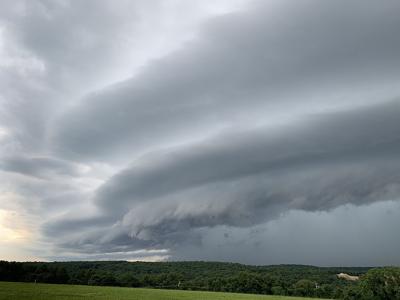
Shelf cloud formation occurs when a downdraft of rain-cooled air from a convective storm reaches the ground and spreads out as a gust front. This cold outflow wedges beneath warm, moist air at the surface, forcing it upwards to condense and create the distinct, horizontal arcus cloud feature.
Key takeaways
A shelf cloud is an arcus cloud that forms on the leading edge of a thunderstorm or squall line.
The process starts with a convective downdraft that brings cooler air down to the surface.
The spreading cold pool acts as a gust front and lifts warm air into a visible cloud band.
Shelf clouds usually point to strong winds and heavy rain, not a tornado.
Their smooth leading edge and ragged underside come from fast-moving air and turbulent mixing.
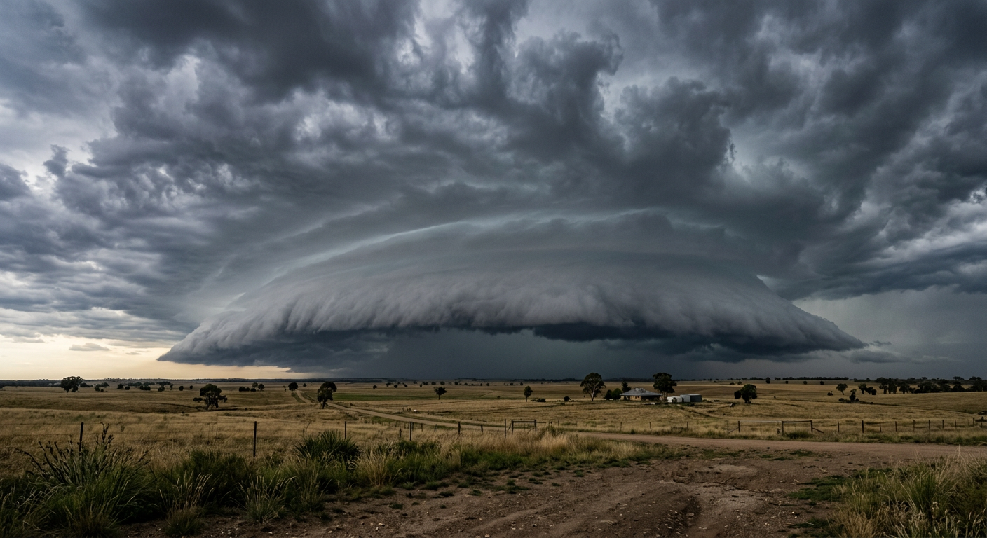
A wide-angle photographic view of a wedge-shaped shelf cloud formation approaching over a rural sector.
Shelf cloud formation explained
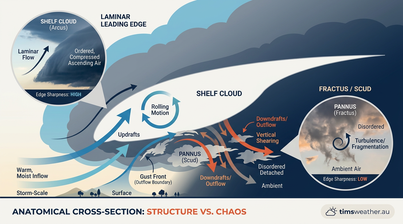
Close up photography showing the turbulent underside of a shelf cloud compared to its smooth top edge.
Shelf clouds form when rain-cooled air from a thunderstorm spreads out at the surface and lifts warmer air ahead of it. The key driver is the storm's downdraft, which is described in BoM storm guidance as part of severe thunderstorm structure.
For a broader view of how the parent cloud develops, see how do cumulonimbus clouds form. A shelf cloud is one part of that larger storm system, usually tied to the forward edge of the precipitation core.
What is an arcus cloud?
An arcus cloud is a low, horizontal cloud formation linked to cumulonimbus storms. The shelf cloud is the wedge-shaped type, while a roll cloud is more detached and cigar-shaped. The World Meteorological Organization's cloud classification uses arcus cloud for this group, but the main idea is simple: the cloud marks a strong boundary between air masses.
If you want the short version, shelf cloud formation is what happens when storm-cooled air undercuts warm, humid air and forces it to rise.
How the gust front lifts warm air
The cold outflow from the storm spreads across the ground as a gust front. Because that air is denser, it stays low and pushes underneath the warmer air ahead of it. That lifting is enough to cool the rising air to its dew point, where moisture condenses into cloud droplets.
This is why the cloud base often looks smooth at the front edge but torn and turbulent underneath. The visible shelf is the part where the rising air is being forced up most quickly.
Why stable air layering matters
Stable air layering helps shape the cloud. If the air near the surface is warm and moist, but the air above is cooler, the advancing gust front can raise a sharp cloud band along the boundary. If the layer is less stable, the cloud edge may look more broken and less defined.
That same boundary can also help the storm maintain its structure for a while, especially when the outflow boundary stays organised.
Weather features linked to shelf cloud formation
Several storm terms come up again and again when you read about shelf cloud formation. These links help show how the cloud fits into the full storm structure.
Gust front - the leading edge of the storm's cool outflow
Outflow boundary - the boundary where storm-cooled air spreads outward
Downdraft - air moving down through the storm
Cumulonimbus cloud - the thunderstorm cloud that produces the shelf cloud
Cumulonimbus incus - the anvil-top form that can sit above a mature storm
Thermodynamic stability - how ready the air is to rise or resist rising
Convective downdraft and inflow jet
A strong convective downdraft pulls rain-cooled air downward through the storm. Near the surface, that air spreads out and can help drive an inflow jet of warmer air back towards the storm. In a mature convective storm, that inflow can feed new updrafts while the outflow boundary leads the system forward.
That push-pull between inflow and outflow is part of normal storm structure, and it helps explain why some shelf clouds stay sharp for a long time.
What role do isobaric surfaces play?
Isobaric surfaces are imaginary layers of equal pressure. In a strong thunderstorm, pressure falls and rises around the storm can bend those surfaces slightly. The result is a pressure pattern that supports the storm’s circulation and helps the gust front advance, but this is the gust front’s effect on surrounding air rather than a general description of shelf-cloud formation.
This is part of the reason a shelf cloud can look so organised along a long storm line.
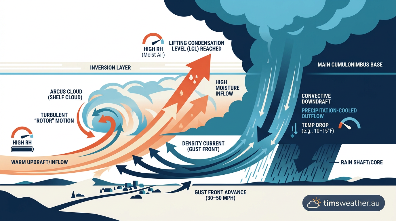
Diagram showing the physical mechanics of shelf cloud formation with cold downdrafts wedging under warm moist air.
How shelf clouds differ from wall clouds
A shelf cloud sits on the leading edge of the storm. A wall cloud forms underneath the updraft base, usually in the rain-free portion of a supercell. The two clouds can look similar at first glance, but they form for different reasons and they sit in different parts of the storm.
If you are comparing them in the field, the distinction matters. A shelf cloud points to the storm's outflow and often brings strong wind gusts. A wall cloud sits lower, near the storm's inflow, and can be tied to rotation.
Supercell anatomy and storm structure
In supercell anatomy, the updraft and downdraft separate more cleanly than they do in ordinary storms. That separation helps the storm stay organised. A wall cloud may form near the rotating updraft, while a shelf cloud stays out on the gust front where cold air spreads forward.
For that reason, the shelf cloud is usually the better clue that heavy rain and strong straight-line winds are close.
Feature | Where it forms | Main airflow | What it usually points to |
|---|---|---|---|
Shelf cloud | Leading edge of the storm | Cold outflow and downdraft | Strong winds and heavy rain |
Wall cloud | Beneath the rain-free base | Warm inflow and updraft | Rotating storm structure |
Roll cloud | Detached from the main cloud base | Horizontal rolling motion | Low, tube-like cloud band |
What the Bureau of Meteorology says about these storms
The Bureau of Meteorology (BOM) classifies shelf clouds as part of severe thunderstorm behaviour, especially when a strong gust front pushes out ahead of the rain core. If a shelf cloud is moving towards you, the storm may already be sending out damaging wind gusts.
That is why the cloud is worth watching, even though the cloud itself is not the hazard. The hazard is the wind, rain, hail and lightning that can follow soon after.
Related guides
Frequently asked questions
A shelf cloud is a low-hanging, horizontal cloud formation attached to the leading edge of a thunderstorm. It forms when cold, rain-cooled air sinks as a downdraft and spreads outward as a gust front. This cold air undercuts warm, moist air ahead of the storm, forcing it to rise and condense.
Source: abc.net.au
Further reading and resources
Explore trusted articles, books, videos and other resources to go deeper on this topic.
weather.govReference
Shelf Cloud versus a Wall Cloud
Background reference on How do shelf clouds form? The mechanics of shelf cloud formation from weather.gov.
youtube.comVideo
What is Shelf Cloud? | Amazing Storm Cloud Explained
Video coverage on How do shelf clouds form? The mechanics of shelf cloud formation from youtube.com.
en.wikipedia.orgReference
Arcus cloud
Background reference on How do shelf clouds form? The mechanics of shelf cloud formation from en.wikipedia.org.
gulfcoastnewsnow.comArticle
Weather Blog: How do shelf clouds form?
In-depth coverage on How do shelf clouds form? The mechanics of shelf cloud formation from gulfcoastnewsnow.com.
iowaweather.comArticle
Shelf Cloud vs. Wall Cloud: What is the Difference
In-depth coverage on How do shelf clouds form? The mechanics of shelf cloud formation from iowaweather.com.
whatsthiscloud.comArticle
Arcus Cloud Feature: Shelf Cloud, Gust Collar
In-depth coverage on How do shelf clouds form? The mechanics of shelf cloud formation from whatsthiscloud.com.
Planning weeks ahead?
Check Australia's long-range seasonal outlook for rainfall, temperature and the climate drivers (ENSO, IOD, SAM, MJO) shaping the next three months.
View Australia's Seasonal Weather Forecast