

How do arcus clouds form? They appear when thunderstorm outflow spreads across the ground as a gust front and lifts warm, moist air ahead of it. As that air rises, it cools to its dew point and condenses into a low, horizontal cloud band.
Key takeaways
- Arcus clouds form along the leading edge of thunderstorm outflow, usually near a gust front.
- Shelf clouds stay attached to the parent cumulonimbus cloud, while roll clouds are detached.
- The lifting condensation level is the height where rising air cools enough for cloud droplets to form.
- Atmospheric stability, vertical wind shear, inversion layers and thermodynamics all affect how well arcus clouds hold together.
- The Bureau of Meteorology (BOM) treats these clouds as signs of nearby thunderstorm winds, a sharp temperature drop and shifting conditions.
How do arcus clouds form?
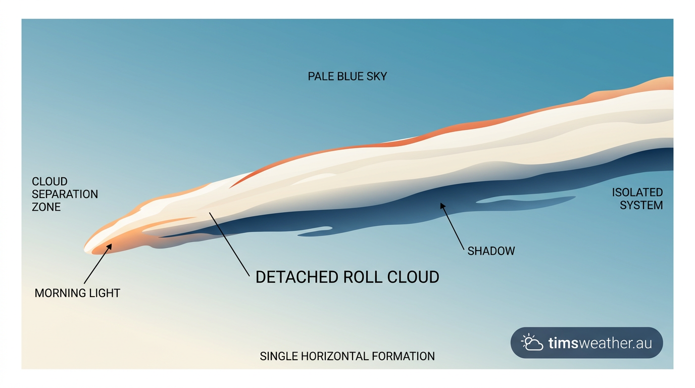
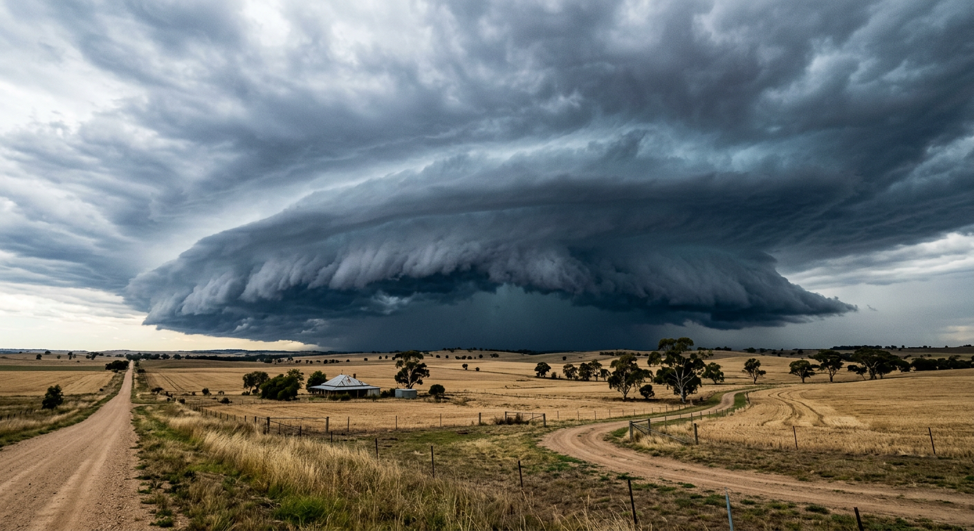
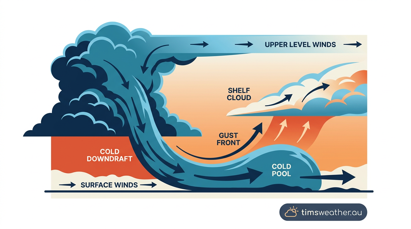
Arcus clouds usually develop on the edge of a mature thunderstorm. Rain-cooled air and hail-cooled air fall through the storm as a downdraft. When that cold air reaches the surface, it spreads outward as thunderstorm outflow. Because it is colder and denser than the air ahead of it, it acts as a density current and pushes under the warmer air.
That pushing edge is the gust front. The front forces warm, moist air to rise. As the air rises, pressure falls, the parcel expands and cools, and thermodynamics does the rest. Once the air reaches its lifting condensation level, water vapour condenses into droplets and the cloud becomes visible.
The cloud often looks like a low horizontal wedge or tube because the lift happens along a long boundary, not in one spot. That is why arcus clouds often stretch across much of the storm front.
The role of Australian low-level jets in arcus development
Low-level jets can help keep thunderstorm outflow organised near the ground. In some Australian setups, stronger low-level winds feed warm, moist air into the storm while also helping the gust front move forward. That can sharpen the boundary and make shelf cloud formation easier to see. Vertical wind shear can then tilt and shape the cloud edge, while atmospheric stability and an inversion layer can help trap the cool outflow close to the ground.
If you want the broader storm setup, see how do thunderstorms form.
What the cloud edge tells you
A well-defined arcus cloud often signals a strong outflow boundary. You may notice a sudden wind shift, a temperature drop and dust or rain approaching with the boundary. The cloud itself does not cause the hazard, but it often marks where the stronger winds are about to arrive. BOM storm spotter guidance uses these features as clues that the storm’s leading edge is active.
Shelf clouds versus roll clouds
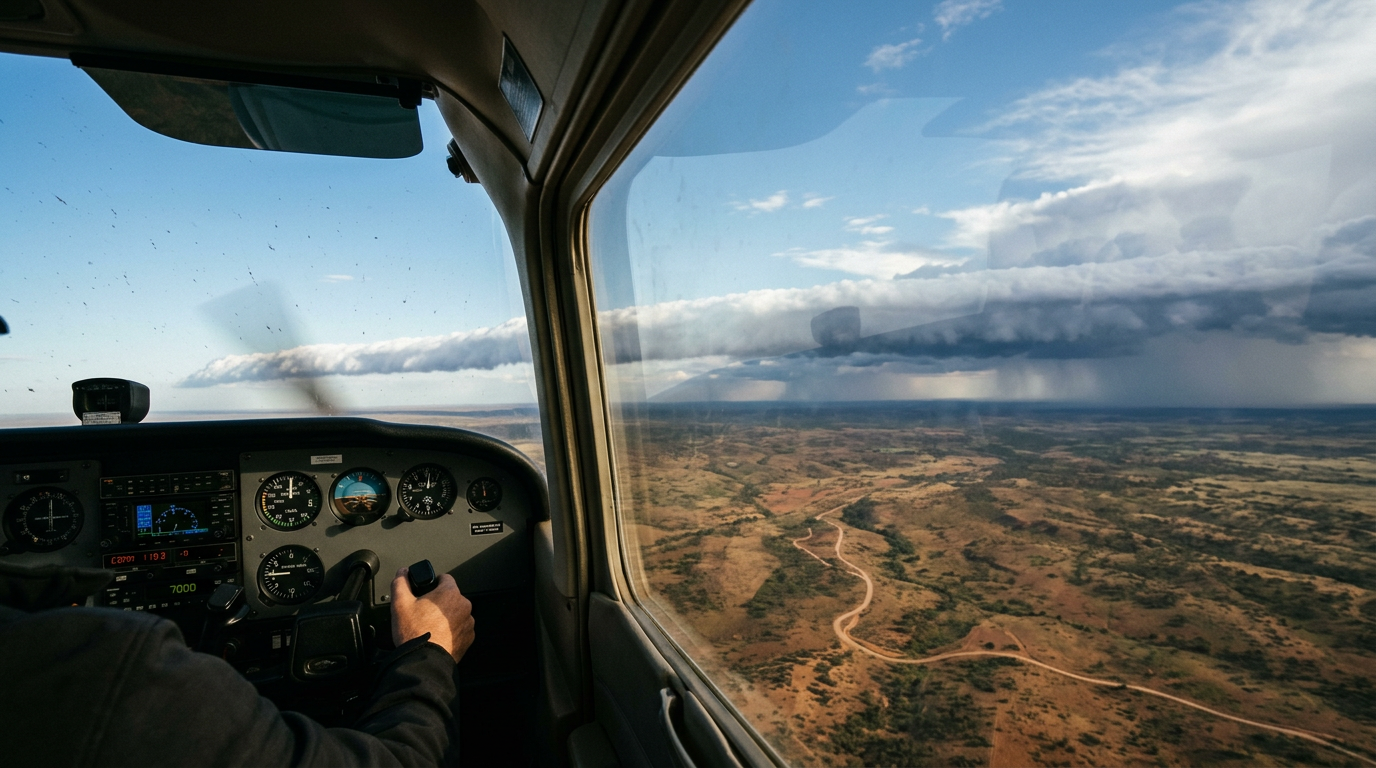
Arcus clouds come in two main forms. A shelf cloud remains attached to the thunderstorm base. A roll cloud is detached and can sit several kilometres ahead of the rain core. Both are linked to the same basic process, but the wind field around the gust front changes how they look.
What causes a shelf cloud?
A shelf cloud forms when cool outflow from a thunderstorm’s downdraft undercuts warm air ahead of the storm at the gust front, causing the warm air to rise and condense. The result is a dark, wedge-shaped cloud under the storm base. Shelf cloud formation is most common when the storm motion and the outflow boundary move at similar speeds.
What is the difference between a roll cloud and a shelf cloud?
A roll cloud is detached from the parent storm. It usually has a smooth, tube-like shape and can appear to roll along a long boundary. The World Meteorological Organization’s International Cloud Atlas classifies arcus as a supplementary feature, not as volutus. Roll clouds form when the outflow boundary and the surrounding wind shear set up a rotating horizontal motion near the cloud base.
Is an arcus cloud the same as a wall cloud?
No. An arcus cloud forms along the leading edge of thunderstorm outflow. A wall cloud forms lower down under the storm’s inflow region, near the updraft. They are different features and they form in different parts of the storm.
| Feature | Shelf cloud | Roll cloud |
|---|---|---|
| Attachment | Attached to the cumulonimbus cloud | Detached from the parent storm |
| Typical shape | Dark wedge or shelf | Horizontal tube or cylinder |
| Main driver | Gust front lifts warm air | Outflow boundary and wind shear |
| What it often signals | Incoming squally winds | Passing outflow boundary |
How the Great Dividing Range influences shelf cloud persistence
The Great Dividing Range can help some shelf clouds hold their shape for longer. Rising terrain can slow or redirect thunderstorm outflow, while valleys and ridges can focus the wind field along the boundary. That can make the cloud edge more persistent in one location, especially when the storm is moving across uneven ground.
In other cases, the range breaks up the outflow and the cloud loses its clean shape. The outcome depends on storm speed, local wind shear, moisture near the ground and how stable the air is ahead of the boundary.
What to watch for if you see an arcus cloud
An arcus cloud is worth a close look because it can mark a strong storm boundary. If you are outdoors, watch for sudden wind gusts, falling temperature, dust, hail, heavy rain and fast changes in wind direction. If the storm is nearby, move indoors and stay clear of trees, power lines and open water.
For current warnings and storm updates, check the Bureau of Meteorology.
Related guides
Frequently asked questions
Arcus clouds form when a thunderstorm's cold downdraft hits the ground and spreads out as an outflow boundary. This dense, cool air wedges underneath warmer, moist air ahead of the storm. As the warm air is forced upward, it cools and condenses into a distinct horizontal cloud formation.
Source: nesdis.noaa.gov
Further reading and resources
Explore trusted articles, books, videos and other resources to go deeper on this topic.
astropartigirl.comArticle
An Arcus Cloud Brings Forth a Storm! - The Astropartigirl
In-depth coverage on How do arcus clouds form? Shelf clouds, roll clouds and gust fronts from astropartigirl.com.
en.wikipedia.orgReference
Arcus cloud
Background reference on How do arcus clouds form? Shelf clouds, roll clouds and gust fronts from en.wikipedia.org.
skybrary.aeroArticle
Arcus | SKYbrary Aviation Safety
In-depth coverage on How do arcus clouds form? Shelf clouds, roll clouds and gust fronts from skybrary.aero.
whatsthiscloud.comArticle
Arcus Cloud Feature: Shelf Cloud, Gust Collar
In-depth coverage on How do arcus clouds form? Shelf clouds, roll clouds and gust fronts from whatsthiscloud.com.
cloudappreciationsociety.orgArticle
Arcus
In-depth coverage on How do arcus clouds form? Shelf clouds, roll clouds and gust fronts from cloudappreciationsociety.org.
forecast.weather.govReference
NOAA's National Weather Service - Glossary
Background reference on How do arcus clouds form? Shelf clouds, roll clouds and gust fronts from forecast.weather.gov.
mystateline.comArticle
The difference between a shelf cloud and a roll cloud
In-depth coverage on How do arcus clouds form? Shelf clouds, roll clouds and gust fronts from mystateline.com.
crystalinks.comArticle
Arcus, Shelf, Roll, Morning Glory Clouds - Crystalinks
In-depth coverage on How do arcus clouds form? Shelf clouds, roll clouds and gust fronts from crystalinks.com.
Planning weeks ahead?
Check Australia's long-range seasonal outlook for rainfall, temperature and the climate drivers (ENSO, IOD, SAM, MJO) shaping the next three months.
View Australia's Seasonal Weather Forecast