
How do thunderstorms form? Thunderstorms form when moist air rises in an unstable part of the troposphere and keeps rising long enough to build a cumulonimbus cloud. The Bureau of Meteorology (BOM) says thunderstorms need moisture, lift and atmospheric instability. As rising air cools, water vapour condenses, latent heat of condensation is released and the updraft can strengthen.
Key takeaways
- In southern Australia, cold fronts can turn scattered showers into a line, a common trigger for severe weather development.
- The thunderstorm lifecycle has three stages: towering cumulus, mature and dissipating.
- Thunderstorms can last from 30 minutes to several hours, according to the BOM.
- In Australia, sea breezes, cold fronts and the Great Dividing Range can help trigger storm development.
- Severe storms can bring hail, damaging winds, heavy rain, microbursts and, in some cases, supercells.
The core ingredients: how do thunderstorms form
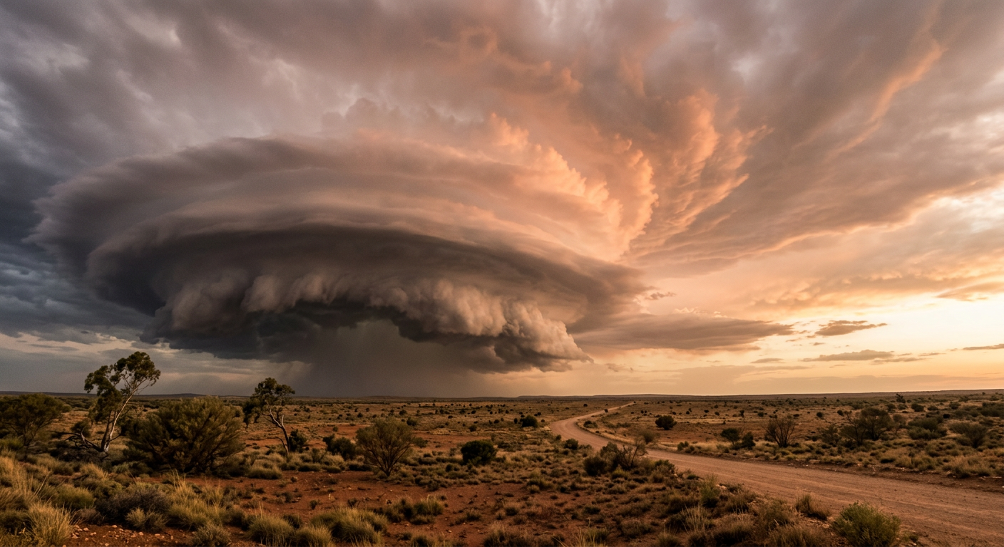
Thunderstorms begin in the troposphere, where air can be lifted, cooled and condensed into cloud. The setup is simple, but the physics matters. You need moisture, a way to lift that air and an atmosphere that becomes cooler with height fast enough to keep the air rising. The BOM explains this combination on its thunderstorms page (Bureau of Meteorology).
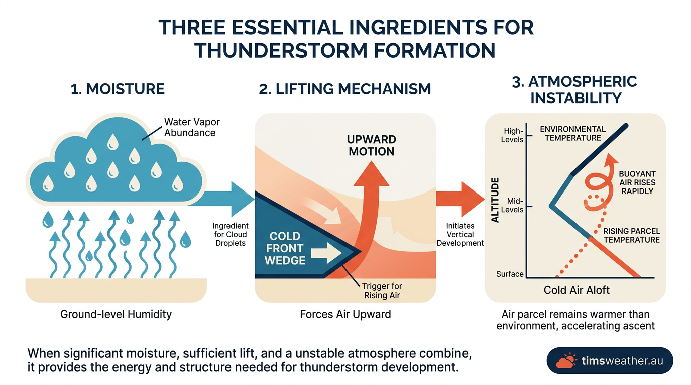
What three factors are required for a thunderstorm to form?
For a thunderstorm to form, the air needs enough moisture, enough lift and enough instability to keep the updraft going. Moisture supplies the water vapour. Lift starts the rise. Instability keeps the parcel of air warmer than its surroundings as it climbs. Without one of those, the cloud may stop growing before it becomes a thunderstorm.
The BOM says thunderstorms can last from 30 minutes to several hours (Bureau of Meteorology).
How does warm air cause a thunderstorm?
Warm air helps because it is less dense than cooler air. On hot afternoons, surface heating can start convection, which is the vertical movement of air as it warms and rises. If the rising air meets enough moisture and the atmosphere stays unstable, the cloud can keep building upward instead of stalling near the ground.
Moisture and the dew point
Moisture is the raw material for clouds and rain. One useful way to judge it is the dew point, which is the temperature air must cool to before water vapour starts to condense. A higher dew point usually means more moisture in the lower atmosphere and a better chance of cloud growth if lift is available.
If you are checking the Weather Hub, watch for warm afternoons with a higher dew point. That often means there is enough moisture nearby for showers or storms to develop if a trigger arrives.
Atmospheric instability and latent heat of condensation
Atmospheric instability means a lifted bubble of air stays warmer than the air around it. That matters because the warmer bubble keeps rising. As it rises, it cools and reaches the condensation level, where cloud droplets begin to form. That change releases latent heat of condensation, which feeds the updraft and helps the cloud grow taller.
The cap: why some storms fail to form
Sometimes the sky stays quiet even when the air feels muggy. A warm layer aloft can act like a cap, or inversion, that stops surface air from rising. If the cap is strong, the storm never gets started. If a cold front, sea breeze or strong heating breaks the cap, thunderstorm development can begin quickly.
Stages of thunderstorm formation
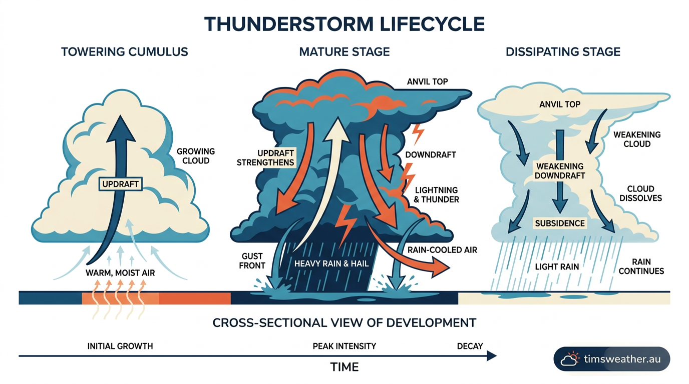
Once a storm starts, it usually moves through three stages. Each stage shows a different balance between updrafts and downdrafts.
The towering cumulus stage
This is the build-up stage. Strong updrafts push moist air upward and the cloud towers higher into the troposphere. Rain usually has not reached the ground yet, but the cloud is gathering energy. If the updraft stays strong, the cloud can keep growing into a cumulonimbus cloud.
The mature stage
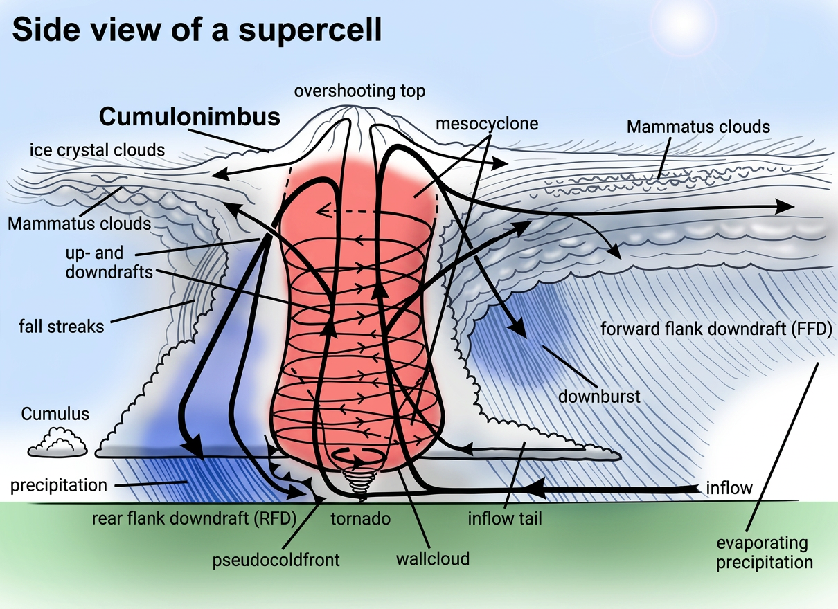
The mature stage is when the storm is at its strongest. The cloud has both updrafts and downdrafts working at the same time. Rain, hail and lightning are most likely in this phase. If wind shear is strong enough, the storm can tilt its updraft and organise itself into a supercell, which can help the storm last longer and become more severe.
The dissipating stage
During the dissipating stage, the downdraft starts to cut off the warm inflow that feeds the storm. Cold air spreads out near the surface and weakens the updraft. Rain eases, the cloud base breaks apart and the storm slowly fades.
Dry line triggers and other storm triggers
Some storms need more than heat and humidity. Cold fronts, sea breezes and dry lines can all force air upward. Orographic lift matters too, especially where air is pushed over higher ground such as the Great Dividing Range. That rise helps cool the air and can spark new storm cells on the windward side of the range.
What makes a thunderstorm severe?
Severe storms are the ones that create the biggest hazards for people and property. The BOM warns on severe thunderstorms when they are likely to produce large hail, damaging winds or heavy rainfall that may lead to flash flooding (Bureau of Meteorology).
One damaging feature is a microburst, which is a strong downdraft that hits the ground and spreads out suddenly. That outflow can bring very strong winds over a small area. Severe storms can also form as supercells when wind shear separates the storm’s updraft from its downdraft.
How do cold fronts affect thunderstorms?
Cold fronts can be a strong trigger because they force warm air to rise quickly. If the air ahead of the front is moist and unstable, the front can turn scattered showers into a line of thunderstorms. This is common across southern Australia when cooler air pushes into a warmer airmass.
The Role of the East Australian Current in Storm Intensification
Along the east coast, warm sea surface conditions can add moisture to the lower atmosphere. The East Australian Current is part of that coastal setup and is often discussed in eastern Australian weather patterns, especially when humid onshore flow is in place. If that moist air is then lifted by a sea breeze, trough or terrain, storm clouds can grow more easily.
How the BOM tracks thunderstorms
The BOM watches for the ingredients that support storms, then issues warnings when severe weather is likely. That includes strong winds, hail, intense rainfall and the risk of flash flooding. If you are in an area with active storms, keep an eye on the latest Weather Hub updates and any BOM warnings.
Related guides
Frequently asked questions
A thunderstorm requires three main ingredients: moisture, atmospheric instability, and a lifting mechanism. Warm, humid air must be forced upwards, where it cools and condenses into a towering cumulonimbus cloud. If the atmosphere remains unstable and supports this rising air, the storm can intensify and produce lightning and thunder.
Source: bom.gov.au
Further reading and resources
Explore trusted articles, books, videos and other resources to go deeper on this topic.
youtube.comVideo
Why Brisbane and Southeast Queensland see so many Powerful ...
Video coverage on How Do Thunderstorms Form? An Explainer on Australian Storm Development from youtube.com.
bom.gov.auReference
Storm Spotters' Handbook
Background reference on How Do Thunderstorms Form? An Explainer on Australian Storm Development from bom.gov.au.
britannica.comReference
Thunderstorm | Definition, Types, Structure, & Facts
Background reference on How Do Thunderstorms Form? An Explainer on Australian Storm Development from britannica.com.
theillawarraflame.com.auArticle
Thunderstorm 101: The science of storms explained
In-depth coverage on How Do Thunderstorms Form? An Explainer on Australian Storm Development from theillawarraflame.com.au.
en.wikipedia.orgReference
Thunderstorm
Background reference on How Do Thunderstorms Form? An Explainer on Australian Storm Development from en.wikipedia.org.
weather.govReference
THUNDERSTORMS
Background reference on How Do Thunderstorms Form? An Explainer on Australian Storm Development from weather.gov.
scied.ucar.eduReference
How Thunderstorms Form - UCAR Center for Science Education
Background reference on How Do Thunderstorms Form? An Explainer on Australian Storm Development from scied.ucar.edu.
Thunderstorms | The Bureau of Meteorology
Background reference on How Do Thunderstorms Form? An Explainer on Australian Storm Development from bom.gov.au.
nssl.noaa.govReference
Severe Weather 101: Thunderstorm Basics
Background reference on How Do Thunderstorms Form? An Explainer on Australian Storm Development from nssl.noaa.gov.
australianenvironmentaleducation.com.auArticle
Storms
In-depth coverage on How Do Thunderstorms Form? An Explainer on Australian Storm Development from australianenvironmentaleducation.com.au.
Planning weeks ahead?
Check Australia's long-range seasonal outlook for rainfall, temperature and the climate drivers (ENSO, IOD, SAM, MJO) shaping the next three months.
View Australia's Seasonal Weather Forecast