

Microburst formation occurs when a localised column of sinking air, or convective downdraft, is rapidly accelerated by evaporative cooling and precipitation loading. As this dense air strikes the ground, it violently spreads horizontally in all directions, creating severe straight-line winds capable of damaging local infrastructure.
Key takeaways
Microbursts produce intense straight-line winds over a highly localised area of less than four kilometres in diameter.
The core mechanism relies on evaporative cooling, which makes the descending air colder and denser than its surroundings.
Aviation safety is highly vulnerable to the sudden low-level wind shear created when these downdrafts hit the surface.
Meteorologists classify these events into wet and dry types depending on whether heavy rain successfully reaches the ground.
What is a microburst?
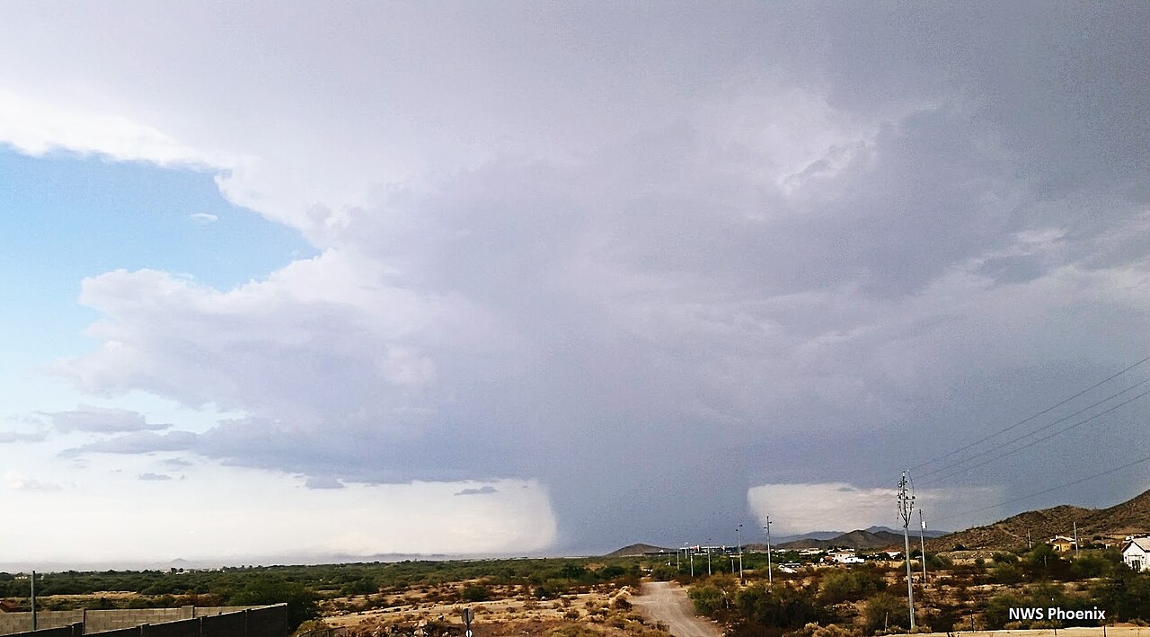
A downburst seen in Phoenix, Arizona. By NWSPhoenix - Own work, CC BY-SA 4.0, https://commons.wikimedia.org/w/index.php?curid=56724205
A microburst is a violent, highly localised downdraft of air that originates from a parent thunderstorm. The formal classification of these systems began with the foundational research of Dr. Ted Fujita in the 1970s. Fujita studied aerial damage patterns that initially looked like tornado strikes. Instead of finding the swirling debris path typical of a vortex, he found starburst patterns, indicating that a concentrated column of air had slammed into the earth and blasted outward in straight lines.
To confirm the existence of these concentrated drafts, Fujita launched the NIMROD project, deploying radar networks to map atmospheric wind fields. The data proved that extreme convective downdrafts happen when a thunderstorm updraft can no longer sustain the heavy rainfall suspended aloft, causing air to rush downward rapidly (www.fox16.com). As the dense air collapses toward the surface, it produces severe straight-line winds that can flatten trees, remove roofs and cause structural damage in seconds.
The difference between microburst and macroburst
Meteorologists differentiate downbursts purely by their physical footprint. The U.S. National Weather Service and meteorological agencies worldwide classify an intense downburst as a microburst when the damage path is less than four kilometres across. A macroburst operates on the exact same physical principles but impacts an area larger than four kilometres in diameter. Because a microburst forces all its kinetic energy into a smaller area, the resulting wind speeds are often far higher and more destructive.
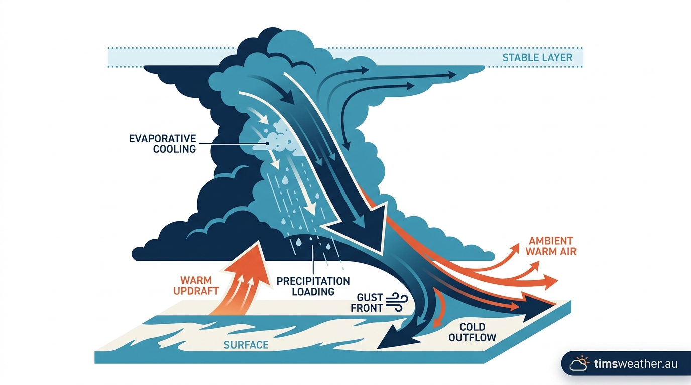
Diagram explaining the physics of how evaporative cooling and negative buoyancy drive convective downdrafts.
Is a microburst worse than a tornado?
While tornadoes and microbursts both inflict catastrophic damage, they operate differently. A tornado is a rotating column of rising air that pulls material inward and upward. A microburst is a descending column of air that pushes material outward and downward. Meteorologists often differentiate between tornadoes and microbursts using radar signatures and the resulting pattern of debris, avoiding misclassification during storm damage surveys. While the very strongest tornadoes generate higher maximum wind speeds on the Fujita scale, severe microbursts occur far more frequently and affect a wider geographical range.
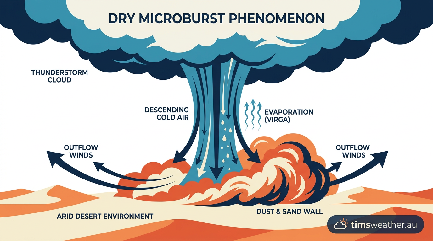
A dry microburst kicking up a massive wall of dust in an arid desert sector.
How microburst formation actually works
The process of microburst formation requires a look inside the turbulent environment of cumulonimbus clouds. When examining how do thunderstorms form, meteorologists usually focus on the initial updraft of warm, moist air. The exact opposite process creates a microburst. It requires atmospheric stability to fail rapidly, forcing massive amounts of heavy, chilled air to accelerate toward the earth.
How do microbursts form during a thunderstorm?
Microburst formation occurs when a localised column of sinking air, or convective downdraft, is accelerated by evaporative cooling or precipitation loading. As this dense air hits the ground, it spreads horizontally in all directions, creating intense wind shear and hazardous conditions for aviation and infrastructure across Australia.
The role of precipitation loading
Inside supercell thunderstorms, fierce updrafts suspend thousands of tonnes of liquid water and solid hail high in the troposphere. Gravity constantly works against this updraft. When the upward air currents inevitably weaken, they drop this immense physical weight. This process is known as precipitation loading. The sheer mass of falling rain and hail physically drags the surrounding air down with it, creating the initial downward momentum.
Evaporative cooling and density currents
While precipitation loading starts the downward movement, evaporative cooling is the catalyst that turns a normal downdraft into a severe hazard. If the falling rain encounters a layer of very dry air beneath the cloud base, the liquid droplets rapidly evaporate. The phase change from liquid water to water vapour consumes latent heat, drawing thermal energy directly from the surrounding environment.
This massive cooling effect forces the air column to contract and become incredibly dense. In meteorology, this state is known as negative buoyancy. The chilled air sinks rapidly through the warmer air surrounding it, accelerating constantly. Forecasters regularly analyze Skew-T diagrams to illustrate lapse rates conducive to these intense downdrafts (www.fox16.com). Once the downdraft hits the surface, it behaves like a dense fluid, and the resulting horizontal outflow acts as a density current.
What is the main cause of a microburst?
The main cause of a microburst is the combination of intense evaporative cooling and precipitation loading within a severe thunderstorm. When dry air is present in the middle and lower levels of the atmosphere, it triggers rapid evaporation of falling rain. This suddenly chills a column of air, making it denser than the surrounding atmosphere and forcing it to plummet.
Types of microbursts: wet versus dry
Meteorologists divide microbursts into two primary categories based on the amount of precipitation that reaches the ground. Both types share the exact same physical mechanics, but they present very different visual cues. Identifying these distinct types of severe thunderstorms in Australia helps forecasters issue timely warnings, as each presents unique forecasting challenges (www.fox16.com).
What is the difference between a wet and dry microburst?
A wet microburst produces heavy, visible rain at the surface, typically forming in highly humid environments like The Tropics or immediate coastal regions. In contrast, a dry microburst occurs when the sub-cloud atmosphere is so arid that all precipitation evaporates mid-air before hitting the ground. Dry microbursts only manifest visibly as a sudden blast of blowing dust at the surface.
Why dry microbursts form in desert regions
Dry microbursts are a specific threat across arid environments like the Australian Outback, interior Western Australia during summer, and the desert southwest of the United States. In these regions, a thunderstorm may develop a high base with a deep, intensely dry layer of air sitting beneath it. A classic dry microburst environment displays an inverted-V profile on a sounding chart, indicating high surface temperatures and extremely low humidity near the ground.
When rain falls into this dry layer, it evaporates entirely. We call this phenomenon virga. Because the rain never hits the dirt, there is no visual warning of the impending wind blast. The evaporative cooling is so extreme that the invisible column of cold air slams into the desert floor, often kicking up a sudden wall of dust and debris without a single drop of rain falling.
Comparing Wet and Dry Microburst Characteristics | ||
Feature | Wet Microburst | Dry Microburst |
|---|---|---|
Moisture Profile | Humid sub-cloud layer | Deep, arid sub-cloud layer |
Precipitation at Surface | Heavy, torrential rain | None (Virga evaporates mid-air) |
Primary Driver | Precipitation loading and cooling | Extreme evaporative cooling |
Visual Warning | Visible rain shaft or "rain foot" | Blowing dust or debris only |
The life cycle of a convective downdraft
Microbursts are incredibly fast atmospheric phenomena. To properly explain how do downbursts form and evolve, meteorologists divide their short existence into distinct physical stages. This rapid life cycle is challenging for airport personnel and emergency services who have only minutes to issue warnings before an event strikes the runway.
How long does a microburst typically last?
A microburst typically lasts between five and fifteen minutes from the moment the downdraft exits the cloud base to the point the surface winds dissipate. The most intense and destructive phase, the initial outburst, usually persists for no more than five minutes, making real-time detection difficult.
Downburst stages: from contact to dissipation
The life cycle begins with the contact stage. The negatively buoyant air column plummets toward the earth, often accompanied by a visible rain shaft. As the leading edge of the downdraft strikes the surface, it enters the outburst stage. Unable to travel any further downward, the air is forced outwards, accelerating horizontally and creating a rapid change in wind speed or direction over short distances (aviation.gleim.com).
During the outburst stage, the winds roll outward in a curling motion, creating a ring of turbulent, highly destructive air. This outflow is often governed by complex atmospheric physics, including the Guldberg-Mohn effect, which helps explain how the sudden spike in local atmospheric pressure dictates the wind's outward path against surface friction. Finally, the system enters the cushion stage and subsequent dissipation. The continuous flow of cold air creates a shallow pool of high pressure at the surface, which eventually acts as a physical buffer, slowing down further descending air.
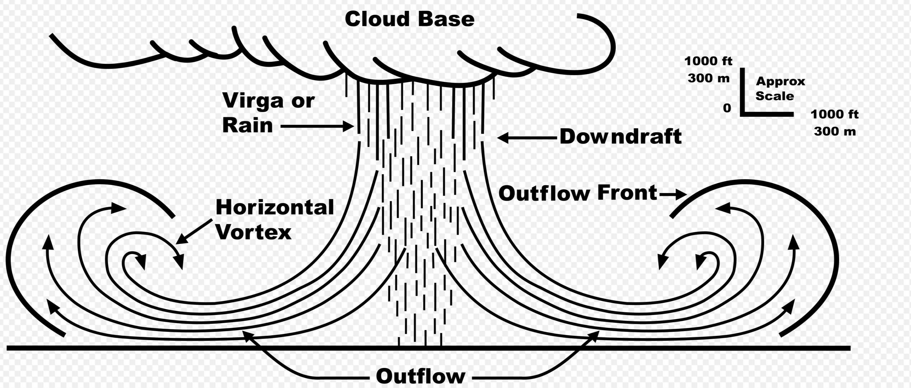
Schematic of a cross-section of a microburst. By Federal Aviation Administration (ed. D. C. Beaudette)vectored byFOX 52 - Microburstcrosssection image, Public Domain, https://commons.wikimedia.org/w/index.php?curid=46182311
Microburst hazards for aviation and infrastructure
While these localized storms cause significant property damage during severe storm events in Southeast Queensland and Northern New South Wales, their most dangerous aspect is the threat they pose to aircraft. Aviation authorities identify low-level wind shear as a rapid fluctuation in wind speed or direction. Flight training manuals consider these abrupt downdrafts to be the most perilous form of wind shear a pilot can encounter (aviation.gleim.com).
Low-level wind shear and terminal velocity
When an aircraft approaches a runway, it relies on a steady flow of air over its wings to generate lift. A microburst completely disrupts this airflow. As a plane flies into the outflow, it first encounters a strong headwind. This temporarily increases airspeed and lift, often causing the pilot to reduce engine power and pitch the nose down to maintain the correct glide path, impacting aircraft performance critically during landing (aviation.gleim.com).
Seconds later, the aircraft crosses into the centre of the downdraft, where the air is sinking violently. Immediately following this, the plane exits the far side of the microburst and encounters a massive tailwind. This sudden transition from headwind to tailwind strips the wings of lift while the aircraft is dangerously close to the ground. The dynamic shifts in air pressure mirror the complexities seen in multicell thunderstorm formation, but they happen in a fraction of the time directly across the flight path.
How do pilots detect microbursts in Australia?
Pilots operating in Australia rely on a combination of onboard weather radar, visual cues, and alerts from the Bureau of Meteorology (BOM). Agencies like Airservices Australia broadcast low-level wind shear alerts derived from advanced Terminal Doppler Weather Radar (TDWR) systems installed at major hubs like Sydney and Brisbane airports to ensure aviation safety.
Case studies and Doppler radar detection
The global aviation community fundamentally changed its approach to wind shear following the tragic crash of Delta Air Lines Flight 191 at Dallas/Fort Worth in August 1985. This event accelerated the global rollout of TDWR systems. These units send microwave pulses into the atmosphere and measure the phase shift of the returning signal. If the radar detects raindrops or dust particles moving rapidly toward the radar on one side of a storm and rapidly away on the other, it indicates a divergent wind pattern consistent with an active downburst.
In local training, the BOM frequently uses 1980s Sydney microburst case studies to demonstrate differential wind shear. By studying these events, meteorologists outline how extreme temperature gradients and severe atmospheric instability combine to threaten major coastal airports. Today, data from peer-reviewed AMS (American Meteorological Society) journals and advanced Doppler radar signatures are the primary defence, allowing controllers to halt runway operations before an aircraft encounters the invisible threat.
Frequently asked questions
Microbursts form when a powerful downdraft of air within a thunderstorm accelerates towards the ground. Upon impact, the air spreads out rapidly in all directions as straight-line winds. These localised events are brief but intense, often causing significant damage despite lasting only a few minutes before dissipating.
Source: garrisonflood.com
Further reading and resources
Explore trusted articles, books, videos and other resources to go deeper on this topic.
pilotinstitute.comArticle
Microbursts: What Makes Them So Dangerous?
In-depth coverage on How Do Microbursts Form? The Science of Severe Thunderstorm Downdrafts from pilotinstitute.com.
weather.govReference
What is a Microburst?
Background reference on How Do Microbursts Form? The Science of Severe Thunderstorm Downdrafts from weather.gov.
en.wikipedia.orgReference
Downburst
Background reference on How Do Microbursts Form? The Science of Severe Thunderstorm Downdrafts from en.wikipedia.org.
abc3340.comArticle
When Downdrafts become Destructive: The Science ...
In-depth coverage on How Do Microbursts Form? The Science of Severe Thunderstorm Downdrafts from abc3340.com.
mdpi.comArticle
Technical Feasibility of Simulating Thunderstorm-Related ...
In-depth coverage on How Do Microbursts Form? The Science of Severe Thunderstorm Downdrafts from mdpi.com.
extension.illinois.eduReference
What is a Microburst? | All About Weather - Illinois Extension
Background reference on How Do Microbursts Form? The Science of Severe Thunderstorm Downdrafts from extension.illinois.edu.
sciencenews.orgArticle
How thunderstorms can spawn damaging 'downbursts'
In-depth coverage on How Do Microbursts Form? The Science of Severe Thunderstorm Downdrafts from sciencenews.org.
noaa.govReference
Thunderstorm Hazards - Damaging Wind - NOAA
Background reference on How Do Microbursts Form? The Science of Severe Thunderstorm Downdrafts from noaa.gov.
ll.mit.eduReference
[PDF] Characteristics of microbursts in the continental United States
Background reference on How Do Microbursts Form? The Science of Severe Thunderstorm Downdrafts from ll.mit.edu.
courses.ems.psu.eduReference
Downbursts | METEO 3: Weather Revealed
Background reference on How Do Microbursts Form? The Science of Severe Thunderstorm Downdrafts from courses.ems.psu.edu.
Planning weeks ahead?
Check Australia's long-range seasonal outlook for rainfall, temperature and the climate drivers (ENSO, IOD, SAM, MJO) shaping the next three months.
View Australia's Seasonal Weather Forecast