
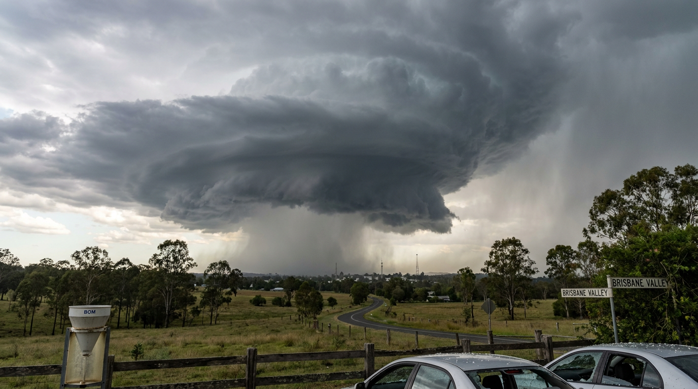
Supercell thunderstorms are highly organised, long-lived storm cells with a rotating updraft called a mesocyclone. In Australia, they are among the most dangerous thunderstorm types because they can produce giant hail, destructive winds, flash flooding and tornadoes. The Bureau of Meteorology (BOM) watches for them with radar, satellite and warning guidance when the atmosphere supports deep rotation.
Key takeaways
- Supercell thunderstorms have a rotating updraft, or mesocyclone, that helps the storm last much longer than a typical storm cell.
- They usually need strong deep-layer vertical wind shear and enough Convective Available Potential Energy (CAPE) to support a powerful updraft.
- Common hazards include giant hail, damaging winds, heavy rain and tornadoes.
- On radar, meteorologists watch for a hook echo, a strong inflow notch and velocity couplets that can mark rotation.
- The Bureau of Meteorology issues severe weather warning products when storms are likely to bring damaging weather.
Supercell thunderstorms explained
What makes a storm a supercell?

A supercell is not defined by height alone. It is defined by organisation. The storm has a persistent rotating updraft, which allows it to keep drawing in warm, moist air while keeping its rain and hail core partly separated from that inflow. That structure is why supercell thunderstorms can remain active for hours, while many ordinary storms rise and collapse in less than an hour.
The BOM groups supercells with the broader set of severe thunderstorms, alongside single-cell and multicell storms in its storm spotters guide. Multicell storms are far more common, but supercells are the ones most often linked with the most intense hazards. If you are watching an approaching storm, the key question is not only how big the cloud looks. It is whether the storm is organised enough to sustain rotation.
The mesocyclone inside the storm
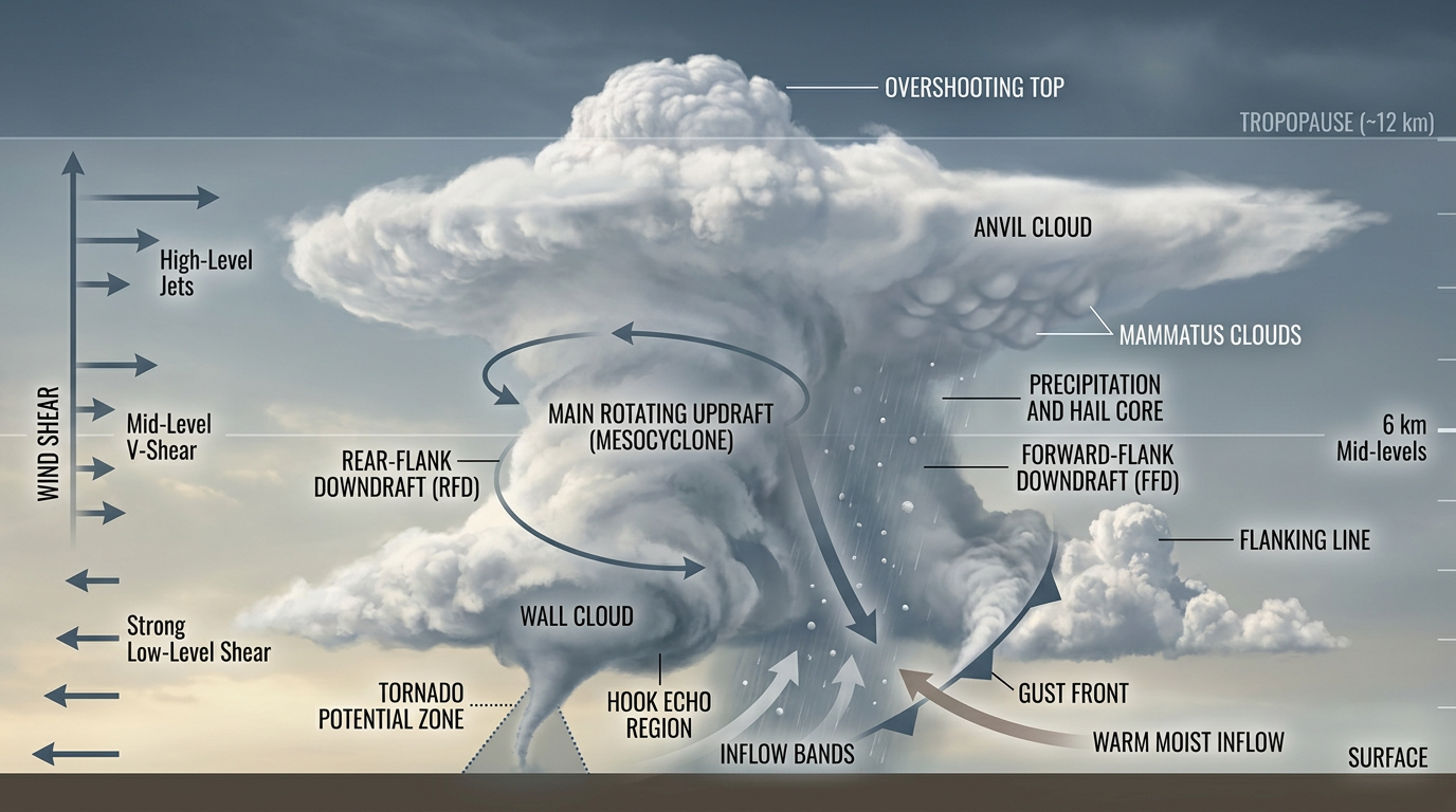
The mesocyclone is the rotating part of the storm that sits inside the main updraft. It forms when winds change with height, first creating a rolling tube of air, then tilting that rotation upright as the updraft strengthens. Once that rotation is established, the storm can keep its structure together for much longer than a normal thunderstorm.
This is also why supercells are watched so closely for tornado genesis. A stronger, more persistent mesocyclone can help the storm spin up tight rotation near the ground, although not every mesocyclone produces a tornado. Many supercells remain non-tornadic, but they can still bring very large hail and damaging winds.
Why the updraft and downdraft matter

Supercells last because the updraft and downdraft stay partly separate. In a simpler storm, falling rain and hail drag cool air down through the rising air and the storm collapses. In a supercell, the rotating updraft tilts the storm structure so the heaviest rain and hail do not fall straight back into the inflow. That separation lets the storm keep feeding on warm air at the surface.
This is also where the storm can become dangerous very quickly. A well-fed updraft can keep growing strong hailstones, while the downdraft can still surge outward and spread damaging wind across a wide area. If you are under a severe weather warning, do not wait for the storm to look worse. Supercells often change quickly once their internal structure is in place.
Right-mover and left-mover storms
When strong wind shear splits a storm, it can separate into two moving cells. One often drifts to the right of the mean wind flow and is called a right-mover. The other drifts to the left and is called a left-mover. This split helps forecasters spot a storm that is organising around rotation rather than simply drifting with the wind.
In Australia, the details depend on the steering winds and the local setup, so there is no simple rule that one mover is always the more dangerous one. What matters is whether the storm keeps rotating and whether it stays separate from nearby storm cells. If the radar and storm motion suggest a sustained turn, forecasters will watch it closely.
Inflow and the anvil cloud
Inflow is the stream of warm, moist air feeding the storm. If you are close to a supercell, you may notice a low, dark base with fast-moving cloud feeding into it. That is often the storm pulling in air to keep its updraft active.
High above the storm, the rising air spreads out into the anvil cloud. The anvil forms when the updraft reaches air that is much more stable and can no longer rise freely. The cloud then spreads sideways. A broad anvil is a classic sign of a mature thunderstorm, and in supercells it often sits over a storm that is still strongly organised.
How supercell thunderstorms form in Australia
Deep-layer vertical wind shear
Strong deep-layer vertical wind shear is one of the main ingredients for supercells. Wind shear means wind speed or wind direction changes with height. Deep-layer shear means that change extends through a deeper layer of the atmosphere, not just close to the ground.
That change in wind creates the spinning tube of air that a supercell can tilt upright. Without enough shear, storms may still become severe, but they are more likely to be short-lived clusters instead of long-lived rotating cells. In practical terms, shear is what helps a storm organise itself instead of collapsing under its own rain and cold outflow.
Convective Available Potential Energy

Convective Available Potential Energy, or CAPE, measures how much buoyant energy is available for rising air. More CAPE means the air parcel can rise more easily and build a stronger updraft, provided other parts of the atmosphere support storm growth.
Supercells usually need both ingredients at once. CAPE helps the storm rise hard. Wind shear helps it stay organised. If one is missing, the storm may still form, but it is less likely to become a classic rotating supercell. That is why forecasters often talk about the combination, not just one number on its own.
Why Australia gets supercells
Australia can produce supercells when warm, moist air near the surface meets stronger winds aloft and a trigger lifts that air into the storm layer. This happens often enough along the eastern states, especially when inland heat, coastal moisture and upper-level wind patterns line up.
The eastern seaboard is well known for severe thunderstorm outbreaks, but supercells can also occur in other parts of the country when the atmosphere is set up correctly. The exact location depends on the day. What matters is whether the atmosphere has enough instability, enough shear and a trigger to break the cap and start storm growth.
How the Bureau of Meteorology tracks supercells
Radar signs that matter
The BOM uses radar to track storm structure and movement. For supercells, meteorologists look for a hook echo, a strong inflow notch and evidence of a rotating core. A hook echo can appear when precipitation wraps around the mesocyclone. That curved shape can be a warning sign that the storm is organising in a way that may support severe weather.
Radar is not used on its own. Forecasters also consider satellite imagery, surface observations and warning data. A storm may show rotation on radar without producing a tornado, but it can still be dangerous if it is growing hail, strengthening winds or sending out heavy rain bands.
What a hook echo can mean
A hook echo is one of the best-known radar signatures linked with supercells. It forms when rain and hail wrap around the rotating part of the storm, leaving a hook-shaped feature on reflectivity imagery. That shape does not guarantee a tornado, but it does tell forecasters that the storm is behaving in a way that needs close attention.
If you are watching a weather update and hear the BOM mention a storm with rotation or a likely severe thunderstorm, treat it seriously. The warning may cover damaging winds, large hail or heavy rainfall, even if a tornado is not mentioned. Supercells can produce more than one hazard at the same time.
How forecasters read rotation
Doppler radar can also show velocity couplets, where air on one side of the storm moves toward the radar and air on the other side moves away. That pattern can indicate rotation inside the storm. It is one of the main tools used to confirm whether a storm is merely strong or whether it has taken on supercell structure.
That is why timing matters. A storm may look ordinary from the ground, yet show rotation on radar. If you are in the path of a warning area, do not wait for a dramatic appearance. Severe thunderstorms can strengthen or shift direction quickly.
What supercell thunderstorms can produce
Giant hail
Giant hail is one of the most damaging hazards from a supercell. Strong updrafts can hold hailstones aloft long enough for them to grow larger before they fall. When they finally drop, they can damage roofs, cars, crops and windows.
The size of the hail depends on how powerful the updraft is and how long the hailstone stays in the storm. A storm with a very strong mesocyclone can keep cycling hail through the growth zone again and again. That is why hail often becomes a major warning focus when supercells are nearby.
Damaging winds and squall lines
Supercells can produce severe wind gusts as the downdraft spreads out from the storm. In some cases, a storm can also be part of a broader line of storms, including a squall line, where several storms organise together. Even then, the supercell within the line can still be the most dangerous cell.
If the BOM warns of damaging winds, the main safety step is simple: move indoors, away from windows and loose objects. Secure anything outside that can become airborne. Supercell winds can arrive with little time to spare, especially if the storm is moving quickly.
Heavy rain and flash flooding
Supercells are famous for hail and wind, but they can also dump heavy rain in a short time. If the storm slows down, back-builds or repeatedly trains over the same area, local flooding can develop quickly. That is especially important in urban areas where drains can clog fast.
Do not drive through floodwater. Even shallow water can hide a washed-out road or a current strong enough to move a vehicle. If a severe weather warning includes heavy rainfall, keep checking BOM updates and be ready to change plans.
Tornadoes
Not every supercell makes a tornado, but the risk is real. Tornado genesis depends on a tight interaction between the mesocyclone, the inflow, the downdraft and the near-surface wind field. When that setup becomes favourable, rotation can tighten near the ground and a tornado may form.
Tornado warnings in Australia are uncommon compared with severe thunderstorm warnings, but the same storm can produce both tornadoes and hail. If you see debris in the air, a rotating cloud base or a sudden roar, take shelter immediately in the safest room you have.
Where supercells occur most often in Australia
Supercells can occur across Australia, but they are most often discussed in the eastern states where moisture and strong wind shear can line up during the warm season. The east coast and nearby inland areas are well known for severe thunderstorm outbreaks, including storms that produce giant hail and damaging winds.
Local geography matters too. Coastal air, inland heating and elevated terrain can all help storms trigger and then intensify. That is why one district may sit under severe storm watches while a nearby area stays quiet. The atmosphere can change over a few tens of kilometres.
How to prepare when supercell thunderstorms are likely
If the BOM issues a severe weather warning for thunderstorms, act early. Supercells can build fast, and the most dangerous phase may arrive before the storm looks fully developed to the eye.
- Check the BOM warning and radar pages regularly.
- Move cars under cover if hail is possible.
- Bring pets, outdoor furniture and loose items inside.
- Stay away from windows and skylights during the storm.
- Avoid driving unless you need to leave immediately.
- If flooding is mentioned, do not drive through water.
For readers in coastal or inland areas of New South Wales, Queensland and Victoria, the practical rule is the same: if the warning mentions damaging winds, large hail or heavy rain, treat the storm as a real threat and keep checking official updates.
Notable Australian supercell events
Australia has a long record of destructive severe thunderstorms, and supercells appear repeatedly in storm reports and storm-spotter accounts. The BOM storm spotters guide points to severe storms as a major part of Australia’s thunderstorm risk, and supercells stand out because of their long life, strong rotation and ability to produce several hazards at once.
Because this article is focused on storm structure rather than a single event list, the most useful takeaway is the pattern. When conditions favour strong shear and instability, the same type of storm can recur in different states from season to season. That is why forecasters keep a close eye on the setup, not just on past storms.
Frequently asked questions
A supercell is a severe thunderstorm characterised by a deep, rotating updraft known as a mesocyclone. These systems are highly organised and can persist for several hours. They are the most dangerous type of thunderstorm, often resulting in large hail, damaging winds, and the potential for tornado development.
Source: weatherzone.com.au
Further reading and resources
Explore trusted articles, books, videos and other resources to go deeper on this topic.
bookshop.nla.gov.auBook
Storm: Chasing Nature's Wildest Weather
A comprehensive book providing deep visual and scientific context on Australian supercells and tornadoes.
podcasts.apple.comPodcast
Supercell Storms and Tornadoes Explained
An informative podcast episode discussing the mechanics of rotating updrafts and Doppler radar tracking.
www.bom.gov.auReference
Storm Spotters' Handbook - BoM
The definitive Australian technical reference for identifying supercell structure and hazards in the field.
www.abc.net.auArticle
What is a supercell storm and why are they so destructive?
A clear journalistic breakdown of how supercells impact the Australian community during peak storm season.
www.britannica.comArticle
Supercell storm | meteorology - Britannica
A concise scientific overview of supercells as the most intense category of thunderstorm.
Storm Chaser Coaching
Offers detailed insights into the different types of supercell classifications, such as HP and LP storms.
en.wikipedia.orgArticle
Supercell - Wikipedia
Provides a high-level summary of the vertical profiles and environmental conditions needed for supercell formation.
www.nssl.noaa.govReference
Severe Weather 101: Thunderstorm FAQ
A detailed FAQ resource answering common questions about supercell life cycles and severe weather output.
Severe Weather 101: Tornado Basics
The most destructive tornadoes occur from supercells, which are rotating thunderstorms with a well-defined radar circulation called a mesocyclone. (Supercells ...
How a supercell thunderstorm can produce violent winds, large hail ...
Supercells are the biggest and baddest kind of severe thunderstorms, capable of producing violent winds in excess of 125 kilometres per hour ...
Planning weeks ahead?
Check Australia's long-range seasonal outlook for rainfall, temperature and the climate drivers (ENSO, IOD, SAM, MJO) shaping the next three months.
View Australia's Seasonal Weather Forecast