
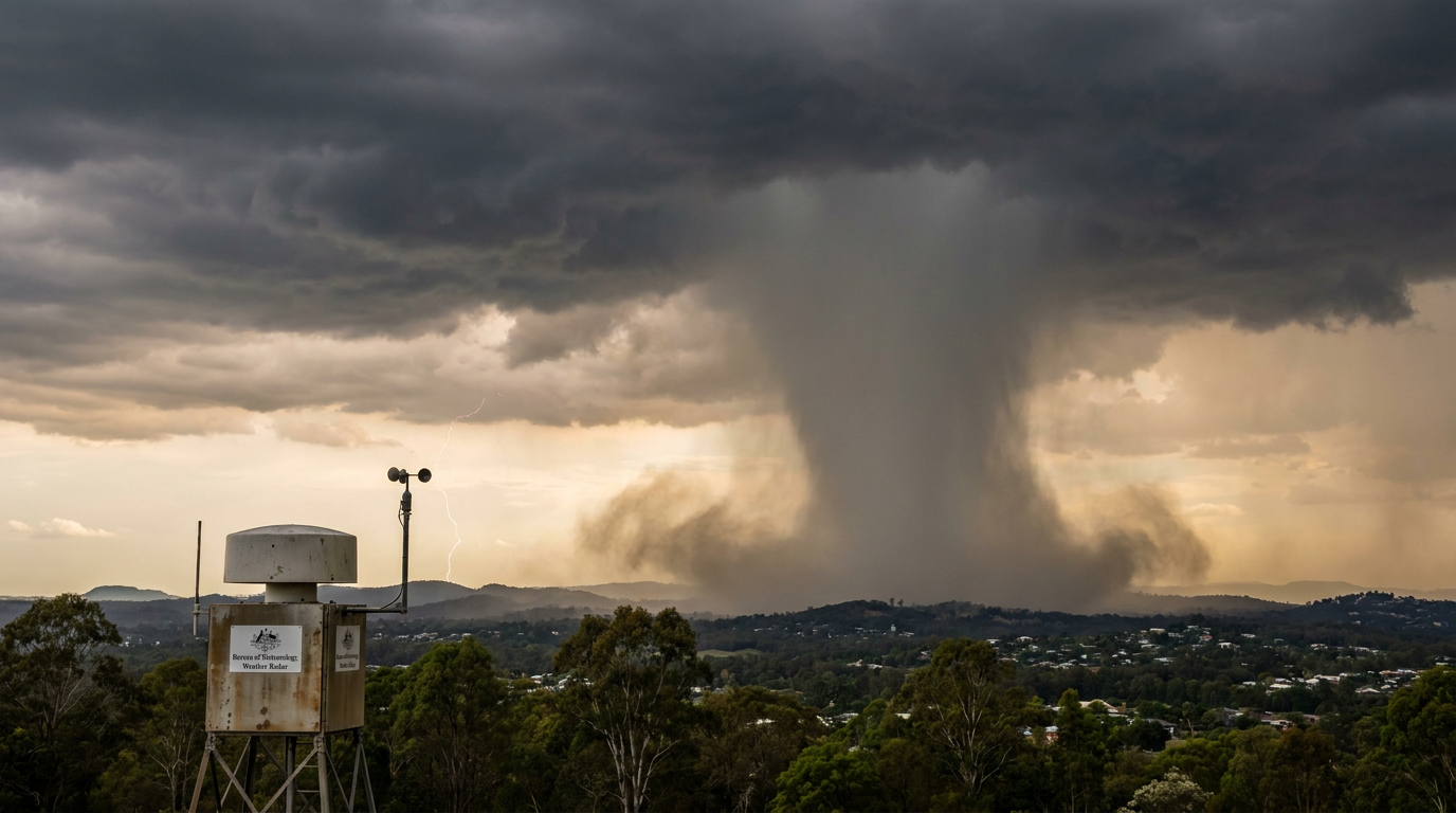
The process of how do downbursts form begins when heavy precipitation or melting hail falls through dry air inside a severe thunderstorm. As this moisture evaporates, it rapidly cools the surrounding air. This cold air becomes incredibly dense, creating severe negative buoyancy that accelerates violently toward the ground.
Key takeaways
Downbursts are powerful downdrafts from thunderstorms that spread destructive straight-line winds upon hitting the surface.
Evaporative cooling and precipitation loading are the two primary atmospheric mechanisms driving this sudden downward acceleration.
Microbursts are highly localised downbursts spanning less than four kilometres, while macrobursts affect much larger areas.
These events pose significant hazards to aviation safety due to intense low-level wind shear during take-off and landing.
Meteorologists use Doppler weather radar to track descending rain and hail cores for early warning.
The meteorological mechanics of how downbursts form
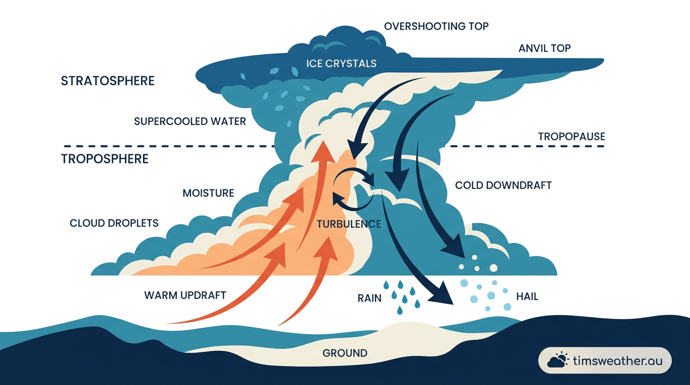
Diagram explaining how do downbursts form through convective downdrafts and evaporative cooling.
To identify the structural threats inside a developing cumulonimbus cloud, meteorologists study the balance between rising updrafts and sinking downdrafts. A convective downdraft begins when rain, hail or snow falls from the upper levels of a thunderstorm. As these hydrometeors fall, they physically drag the surrounding air downward with them. This mechanical process is known as precipitation loading. The sheer mass of millions of falling water droplets and ice particles pushing against the air creates a strong downward current.
During the mature stage of a severe thunderstorm, the main updraft can suspend thousands of tonnes of liquid and solid water high in the atmosphere. When that updraft eventually weakens, all of this suspended mass is released at once. However, physical drag alone is rarely enough to create destructive wind speeds at the surface. The most violent acceleration requires a thermal change.
When mid-level atmospheric winds blow dry air into the rain shaft, a process called entrainment occurs. The falling precipitation begins to evaporate into this ingested dry air. Evaporating water absorbs a massive amount of heat from its surroundings, a thermodynamic shift that rapidly drops the air temperature. If the storm contains hail, the melting of ice introduces the latent heat of fusion. Melting ice extracts even more thermal energy from the ambient air.
This combination of evaporative cooling and melting creates a pocket of extremely cold air aloft. Because cold air is significantly denser than warm air, this chilled pocket gains severe negative buoyancy. It drops toward the earth at high speed. Recent structural analysis compiled in an experimental database of buoyancy-driven downbursts confirms how directly this sudden density shift correlates with peak wind velocities at ground level. As this dense air accelerates downward, it strikes the ground and has nowhere to go but outward, creating a violent horizontal outflow.
Negative buoyancy in Australian thunderstorms
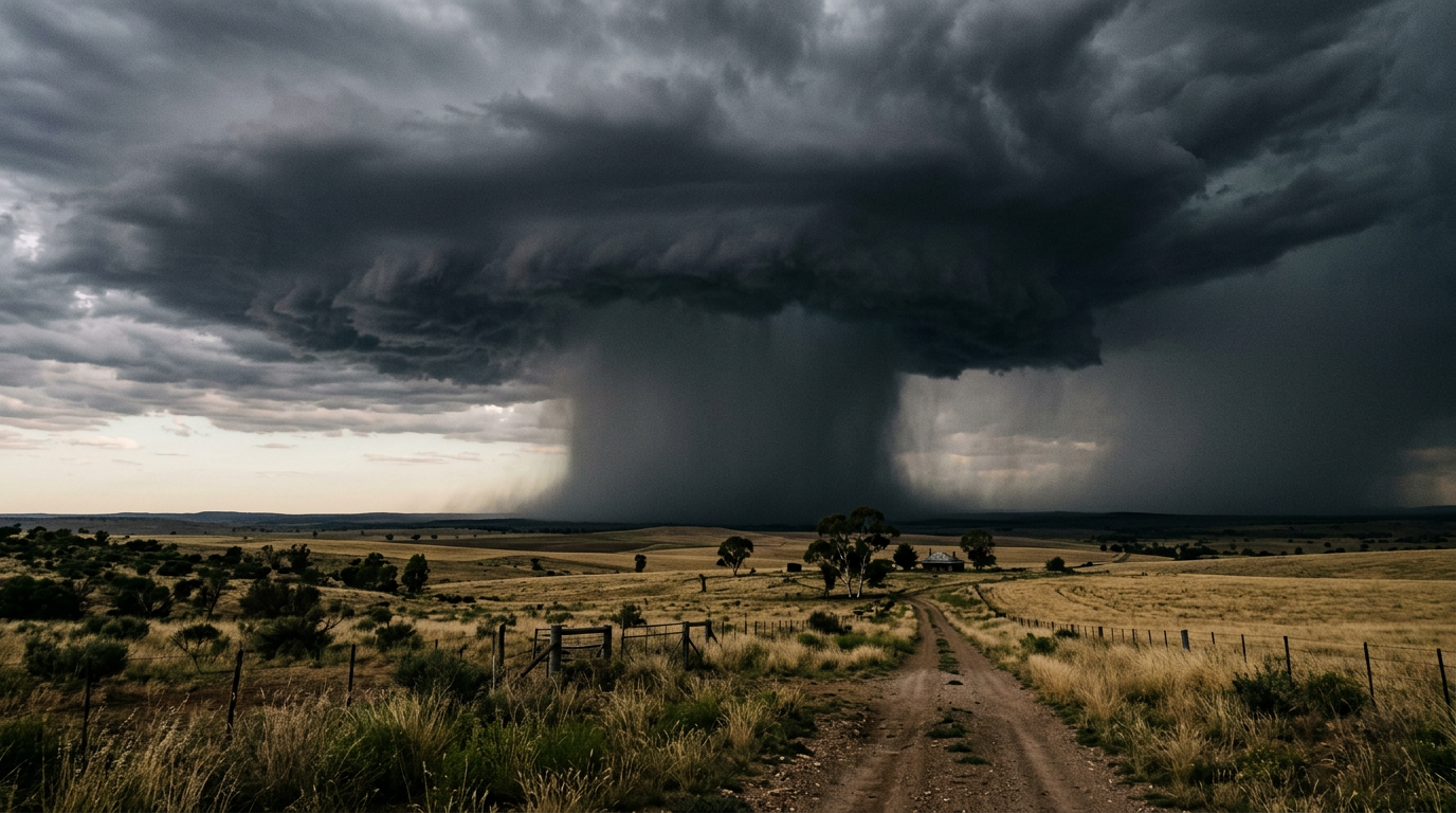
A severe thunderstorm displaying a heavy rain shaft indicative of a strong convective downdraft.
Forecasters at the Bureau of Meteorology map these invisible thermal layers using Skew-T log-P diagrams. These atmospheric diagrams chart temperature and moisture profiles from the surface up to the stratosphere. When a forecaster sees a layer of very dry air sitting a few kilometres above a hot, humid surface layer, they recognise a primed environment for extreme negative buoyancy. If a storm develops in this environment, any rain falling into that dry mid-level air will trigger intense evaporative cooling.
This exact atmospheric profile frequently plagues the Brisbane 'Supercell Alley' storm season. During the spring and summer months, hot surface moisture from the Coral Sea collides with dry air pushing east from the interior deserts. This creates the perfect breeding ground for intense supercell thunderstorms capable of generating massive downbursts. The collision of these distinct air masses forces humid air upwards, while the dry air aloft ensures maximum evaporation when the precipitation finally falls.
Historical analysis of the 1999 Sydney hailstorm demonstrates how severe these downdrafts can become. While the event is famous for its giant hail, the accompanying downburst winds caused significant structural damage by tearing roofing sheets away before the hail impacted the exposed homes. The dense cold pool spreading out from the storm base intensified the destruction by exposing weakened roof cavities to subsequent water ingress.
Dry vs wet downbursts: The impact of mid-level relative humidity
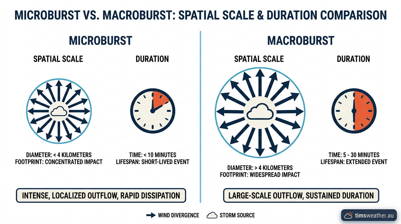
Comparison diagram showing the size and duration differences between a microburst and a macroburst.
The amount of moisture present in the lower atmosphere determines whether a downburst is visually obvious or entirely hidden. In humid regions like Tropical North Queensland, downbursts are almost always wet. The descending column of cold air is accompanied by a visible deluge of heavy rain and hail. Witnesses typically describe a solid grey wall of water accelerating toward the ground and rushing outward upon impact.
Conversely, in the semi-arid environments of Western Australia and the Northern Territory, thunderstorms often operate in very low surface humidity. Rain falls from the high cloud base but passes through kilometres of extremely dry air. The precipitation evaporates completely before it ever reaches the earth, an atmospheric phenomenon known as virga. This is a common sight near towns like Alice Springs, where high cloud bases sit above deeply heated surface layers.
Even though the rain never hits the ground, the evaporative cooling still occurs. This means the invisible cold air still plummets to the ground at high speed. These dry microburst risks in the outback are particularly dangerous because there is no visual warning of a rain shaft. The only clue might be an approaching wall of red dust kicked up by the sudden outflow winds along the surface, making them a significant hazard for rural aviation and high-profile road vehicles.
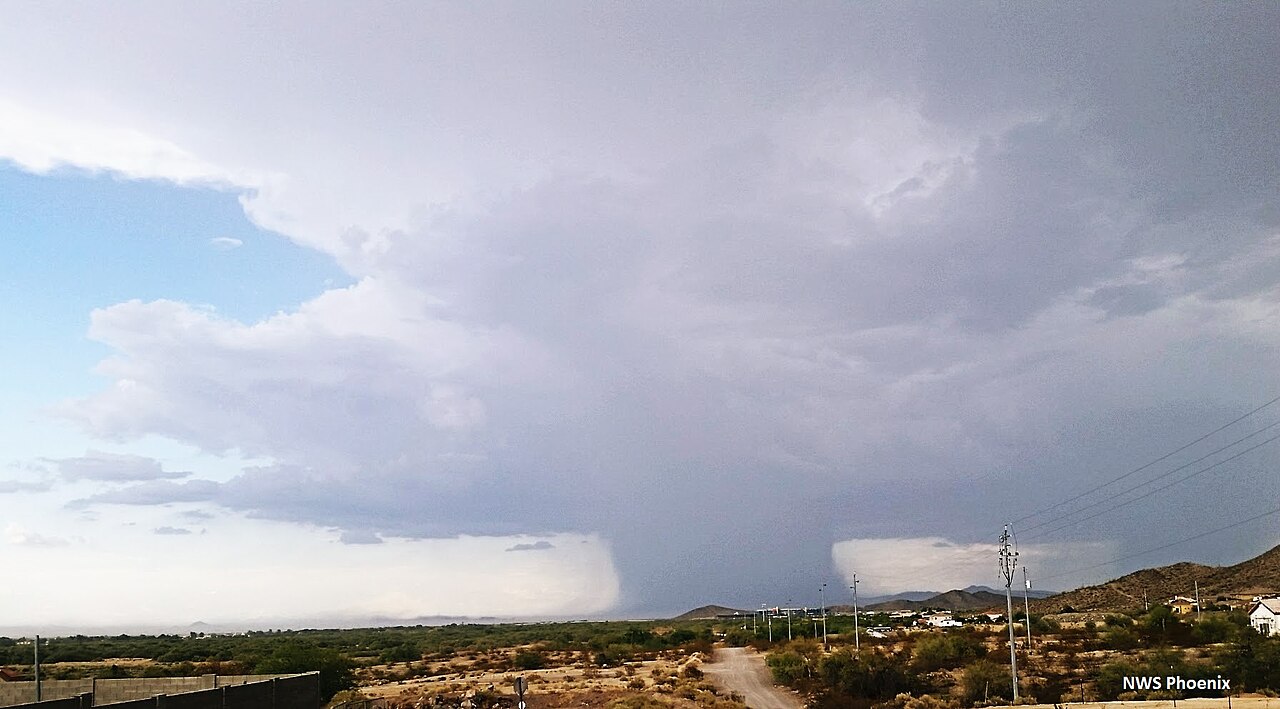
A downburst seen in Phoenix, Arizona. By NWSPhoenix - Own work, CC BY-SA 4.0, https://commons.wikimedia.org/w/index.php?curid=56724205
What are the warning signs of a dry microburst?
The primary visual warning of a dry microburst is a sudden plume of dust or loose dirt billowing up from the ground, despite no rain falling. You may also observe virga, which looks like wispy streaks of grey rain hanging beneath a high cloud base but fading away into dry air before reaching the surface.
How does evaporative cooling cause a downburst?
When rain falls through a layer of very dry air, the water droplets evaporate rapidly. The evaporation process pulls thermal energy out of the surrounding air, dropping its temperature dramatically. This chilled air becomes denser and heavier than the air around it, causing it to sink and accelerate toward the ground due to negative buoyancy.
Categorising convective downdrafts: Microbursts and macrobursts
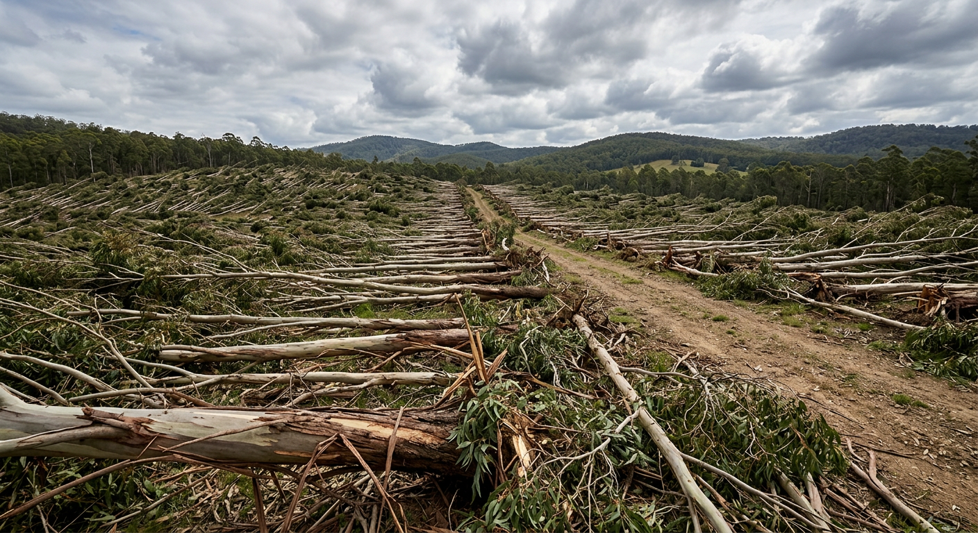
Starburst damage pattern in a forest caused by severe straight-line winds from a downburst.
Meteorologists divide damaging thunderstorm outflows into two primary categories based entirely on their physical footprint. The foundational research for this classification came from Dr Ted Fujita in the 1970s. After observing starburst damage patterns from the air, Fujita proposed that intense, small-scale downdrafts were responsible. This theory culminated in the Joint Airport Weather Studies (JAWS) project, which formally defined the microburst and proved its danger to modern aircraft.
A microburst is a highly concentrated downburst affecting an area of less than four kilometres in diameter. Despite their small size, they pack extreme energy. Peak wind speeds in intense microbursts can exceed 160 km/h, easily strong enough to snap large trees, overturn caravans, and destroy unreinforced structures. Because the descending jet is so concentrated, microbursts typically run their course in under ten minutes.
A macroburst covers a larger footprint, spreading damaging winds outward over an area greater than four kilometres wide. Macrobursts can last for up to half an hour, acting like a giant wedge of cold air surging across the sector. These larger systems often cause widespread power outages and broad property damage across multiple suburbs.
What is the difference between a microburst and a macroburst?
The difference between a microburst and a macroburst lies strictly in their size and duration. A microburst has an impact diameter of less than four kilometres and lasts roughly five to ten minutes. A macroburst impacts an area greater than four kilometres wide and can sustain damaging winds for twenty to thirty minutes as the cold pool expands.
Feature | Microburst | Macroburst |
|---|---|---|
Damage swath diameter | Less than 4 km | Greater than 4 km |
Typical duration | 2 to 10 minutes | 10 to 30 minutes |
Wind speed potential | Up to 270 km/h | Up to 210 km/h |
Primary atmospheric threat | Abrupt, intense wind shear | Widespread structural damage |
Aviation safety: Recognising microburst signatures on approach
Downbursts represent one of the most severe hazards in modern aviation. During the 1970s and 1980s, several tragic commercial airline accidents were traced directly to microburst encounters during final approach or initial climb out. The 1985 crash of Delta Air Lines Flight 191 at Dallas/Fort Worth International Airport stands as a defining case study. The flight encountered a massive microburst that robbed the aircraft of its aerodynamic lift just seconds from the runway. Today, mitigating this risk is a major focus of severe thunderstorm awareness and international aviation training programs governed by bodies like the FAA and ICAO.
The danger stems from abrupt low-level wind shear. When an aircraft flies into a microburst, it first encounters the outflow moving against the direction of travel. This sudden headwind artificially increases airspeed and lifts the wings, causing the plane to rise above its intended glide path. A pilot's natural reaction is to reduce engine power and pitch the nose down to return to the correct altitude.
Seconds later, the aircraft crosses the centre of the downdraft and enters the outflow on the opposite side. The headwind instantly becomes a massive tailwind. The aircraft abruptly loses airspeed and aerodynamic lift just as the engines are spooled down, forcing the plane rapidly toward the ground. Strict aviation safety protocols at major hubs like Sydney Kingsford Smith Airport rely on terminal Doppler radar networks to detect this exact wind shear pattern. Air traffic controllers managed by Airservices Australia will immediately halt arrivals and departures if outflow boundaries are detected crossing the active runways.
Microburst and Downburst Thunderstorm Footage Video
Why downburst damage is often mistaken for tornado paths
Following a severe thunderstorm, rural communities frequently report tornado strikes when they discover flattened crops, uprooted trees, and unroofed sheds. However, post-event damage surveys by meteorologists often reveal the destruction was caused by damaging straight-line winds from a severe downburst rather than a rotating vortex.
The confusion is completely understandable. A severe downburst is entirely capable of causing extensive damage similar to tornadoes. The defining distinction is found in the physical pattern of the scattered debris. Tornadoes are characterised by convergent winds rotating inward and upward. A tornado damage path typically shows trees snapped and twisted inward toward a central line, with debris thrown in multiple chaotic directions.
In contrast, a downburst produces a strongly divergent damage pattern. The wind acts like a giant bucket of water poured from a great height onto a flat floor, spreading rapidly outward from the point of impact. The resulting destruction exhibits a distinct 'starburst' pattern, where trees, fences and crops are blown flat pointing directly away from a central location. Structural engineers evaluating homes after a microburst note that 150 km/h straight-line winds exert massive positive pressure on the windward face of a building, and negative suction on the leeward face, causing uniform blowouts rather than twisting shear.
These grouped macrobursts can occasionally merge into larger systems known as derechos. Derechos are vast, fast-moving thunderstorms capable of producing destructive straight-line winds reaching speeds of 93 to 209 km/h. Unlike isolated microbursts, these massive windstorms often leave damage paths of at least 380 kilometres long, carving continuous swaths of destruction that dwarf the localized footprint of a single tornado event.
Can a downburst be as strong as a tornado?
Yes, a severe downburst can produce wind speeds equivalent to a weak or moderate tornado on The Fujita Scale. Extreme microbursts have recorded wind gusts well over 200 km/h, which is fully capable of destroying timber-framed houses, overturning large vehicles, and snapping mature hardwood trees at the trunk.
Predicting downbursts with weather radar
On a standard rain radar, the first clue is a small, very bright core of red and magenta shading dropping toward the ground. As the cold air hits the surface, the storm's leading edge bulges forward into a bow shape, and a thin line of light blue echo races out ahead of the rain. That thin line is the gust front: the leading edge of the damaging wind, which often arrives before the rain does.
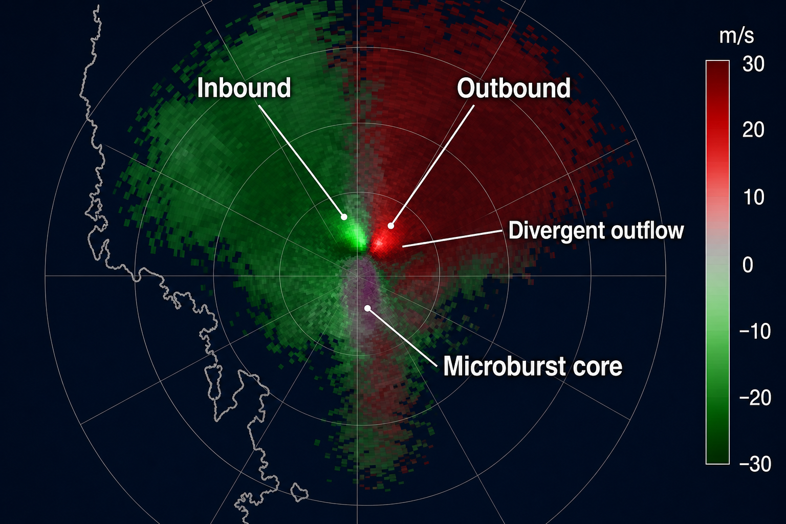
Doppler radar velocity display showing the inbound and outbound couplet of a microburst divergent outflow.
Doppler radar adds the missing piece by measuring wind moving toward and away from the radar. In a microburst you see a tight pair of patches sitting side by side: bright green air rushing toward the radar next to bright red air rushing away. That small couplet means air is spreading outward in every direction from a single point, which is the radar fingerprint of a downburst striking the ground. The tighter and stronger the pair, the more dangerous the surface winds.
Forecasting the exact location and timing of a microburst remains one of the greatest challenges in operational meteorology. Because the descending air column is narrow and short-lived, it easily falls between the observational gaps of standard ground-based weather station networks. Instead, meteorologists rely heavily on advanced Doppler weather radar to peer inside the internal structure of cumulonimbus clouds in real time.
Radar operators look for specific visual signatures in the reflectivity data. A high radar reflectivity core suspended far above the freezing level indicates a massive volume of suspended hail and supercooled water. Case studies from the NOAA National Severe Storms Laboratory (NSSL) show that if this heavy core begins to descend rapidly, it means the supporting updraft has failed and precipitation loading has taken over. By tracking the terminal velocity of this falling core, forecasters can estimate exactly when the downdraft will strike the surface.
Advanced scanning techniques look for specific polarimetric radar signatures, such as the rapid descent of hail and graupel, which signal the start of severe mass loading. Another prominent radar signature is a bow echo, where a solid line of storms bulges outward on the radar screen. This distinct bowing shape is pushed forward by a massive pool of rain-cooled air, signalling that intense straight-line winds are already hitting the ground and surging ahead of the main rain shaft.
Frequently asked questions
Downbursts form when a powerful downdraft of air within a thunderstorm plunges toward the earth. As rain and ice fall through dry air, they evaporate or melt, cooling the surrounding air. This cooler air becomes denser and heavier, accelerating rapidly until it hits the ground and bursts outward violently.
Source: bom.gov.au
Further reading and resources
Explore trusted articles, books, videos and other resources to go deeper on this topic.
weather.govReference
How Do Downbursts Form?
Background reference on How Do Downbursts Form? The Mechanics of Severe Thunderstorm Winds from weather.gov.
en.wikipedia.orgReference
Downburst
Background reference on How Do Downbursts Form? The Mechanics of Severe Thunderstorm Winds from en.wikipedia.org.
Downbursts
Background reference on How Do Downbursts Form? The Mechanics of Severe Thunderstorm Winds from weather.gov.
sciencenews.orgArticle
How thunderstorms can spawn damaging 'downbursts'
In-depth coverage on How Do Downbursts Form? The Mechanics of Severe Thunderstorm Winds from sciencenews.org.
news.fiu.eduReference
What is a downburst? These winds can be as destructive ...
Background reference on How Do Downbursts Form? The Mechanics of Severe Thunderstorm Winds from news.fiu.edu.
mdpi.comArticle
Review of Wind Field Characteristics of Downbursts and ...
In-depth coverage on How Do Downbursts Form? The Mechanics of Severe Thunderstorm Winds from mdpi.com.
cordulus.comArticle
What is a Downburst?
In-depth coverage on How Do Downbursts Form? The Mechanics of Severe Thunderstorm Winds from cordulus.com.
courses.ems.psu.eduReference
Downbursts | METEO 3: Weather Revealed
Background reference on How Do Downbursts Form? The Mechanics of Severe Thunderstorm Winds from courses.ems.psu.edu.
undrr.orgArticle
Downburst (MH0101)
In-depth coverage on How Do Downbursts Form? The Mechanics of Severe Thunderstorm Winds from undrr.org.
estofex.orgArticle
2.2 Straight-line winds - Forecasting severe convective storms
In-depth coverage on How Do Downbursts Form? The Mechanics of Severe Thunderstorm Winds from estofex.org.
Planning weeks ahead?
Check Australia's long-range seasonal outlook for rainfall, temperature and the climate drivers (ENSO, IOD, SAM, MJO) shaping the next three months.
View Australia's Seasonal Weather Forecast