
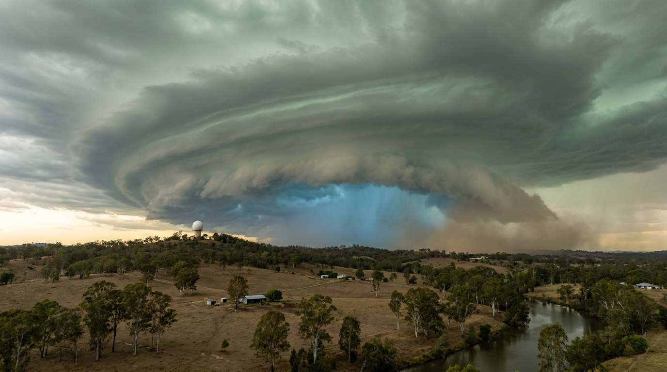
How do bow echoes form? These severe weather features develop when a mesoscale convective system's cold pool strengthens, creating a pressure gradient that pulls high-speed winds downward. This rear-inflow jet pushes the central portion of a convective storm line forward, creating the signature bow shape on radar and causing destructive straight-line winds.
Key takeaways
- A bow echo is a crescent-shaped radar signature that indicates extreme, damaging straight-line winds.
- The formation relies on a delicate balance between atmospheric instability, vertical wind shear, and rain-cooled outflow boundaries.
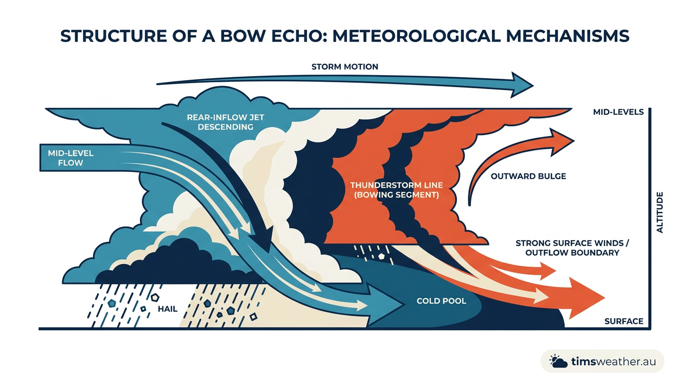
- A rear-inflow jet acts as the driving force, descending from the mid-levels to push the thunderstorm line forward rapidly.
- Book-end vortices develop at either end of the bow, helping to maintain the storm's structure and occasionally producing tornadoes.
- While typically shorter-lived than tropical cyclones, the peak wind gusts in a severe bow echo can cause comparable structural damage over a localised area.
What is a bow echo?
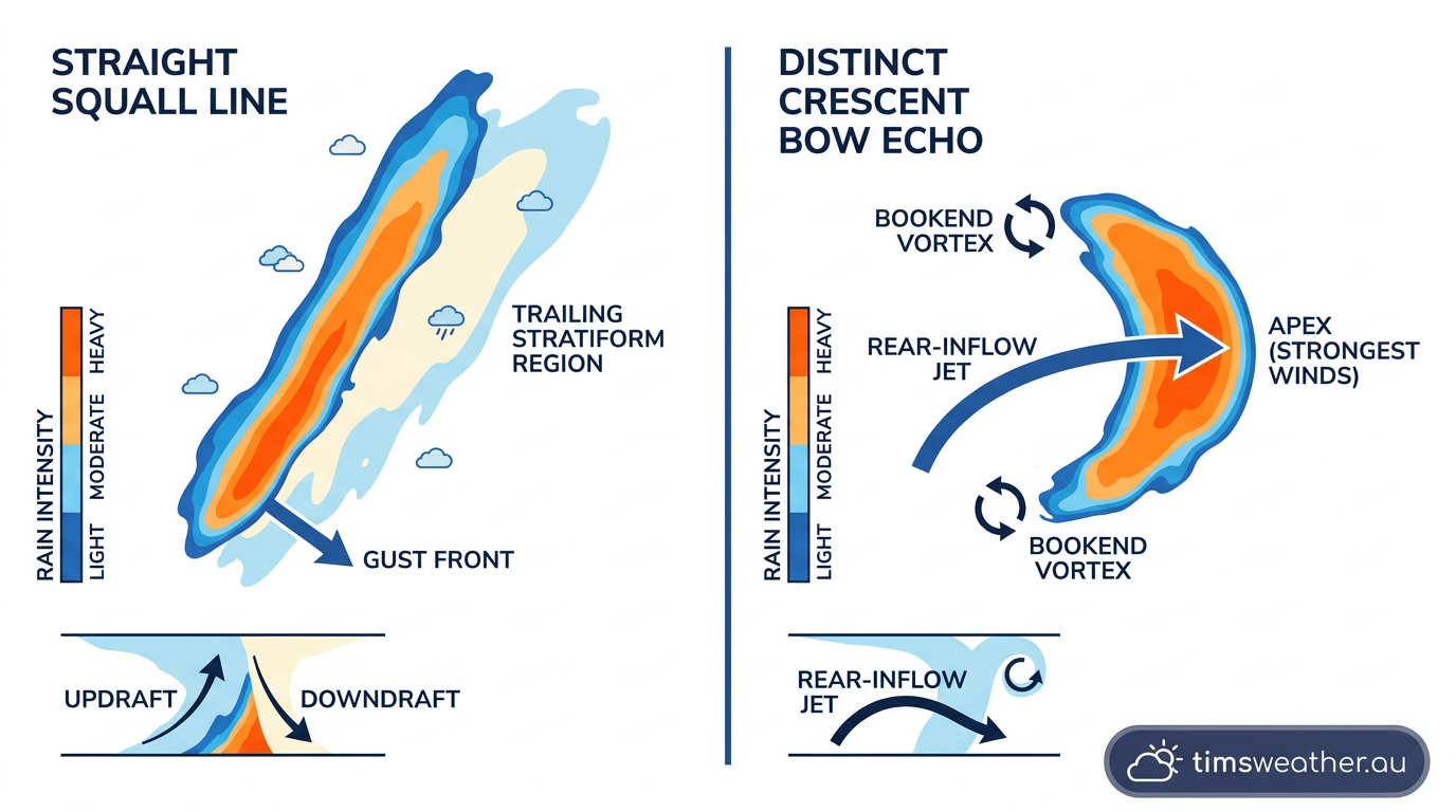
To understand the mechanics of severe convective wind events, meteorologists look for specific structural signatures on Doppler radar. A bow echo refers to a radar signature that appears linear but curves outward in a distinct bow shape, signifying a region of intense straight-line winds. These formations are typically embedded within a broader Quasi-Linear Convective System or large storm cluster.
When atmospheric conditions align, these bowed segments can range significantly in size. They measure anywhere from 20 to 200 kilometres across, with active lifetimes spanning 3 to 6 hours according to the Glossary of Meteorology. The apex, or the leading edge of the bulge, is almost always where the most destructive winds reach the surface. The weather community uses this signature as an immediate warning sign for high-impact wind damage, shifting the threat focus away from large hail and toward gale force winds and sudden downbursts.
What is the difference between a bow echo and a squall line?
A squall line is a long, continuous or semi-continuous band of thunderstorms that can stretch for hundreds of kilometres, typically producing heavy rain and gusty winds along a broad front. A bow echo is a specific, highly intense segment of that line which has curved outwards. This localised bowing indicates that a concentrated jet of air has accelerated one section of the squall line ahead of the rest, signalling significantly stronger, damaging winds compared to a standard straight storm line.
The mechanics: How do bow echoes form?
The progression from scattered thunderstorms to a destructive wind event requires a specific set of atmospheric ingredients. When analysing how mesoscale convective systems organise, meteorologists focus on the balance between atmospheric instability and vertical wind shear.
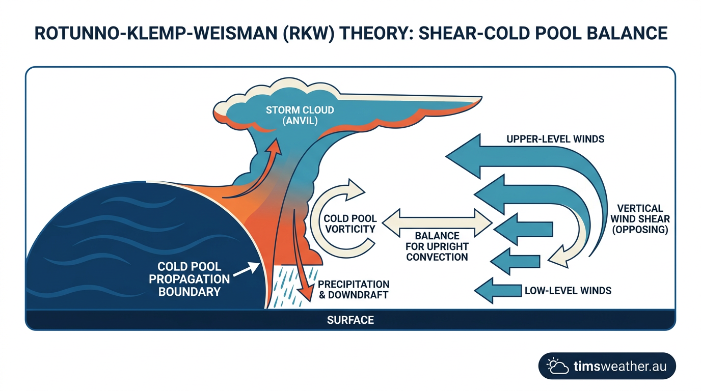
Initially, severe thunderstorms develop as warm, moist air rises rapidly into the upper troposphere. As rain and hail fall through the storm's downdraft, the surrounding air cools rapidly due to evaporation. This dense, heavy air plummets to the ground and spreads out, creating a boundary known as a cold pool. Cold pool propagation acts like a miniature cold front, wedging under warm air ahead of the storm and forcing it upward to fuel new thunderstorm cells. The basic principles of how do thunderstorms form are foundational to seeing how these cold pools interact with their broader environment.
The transition into a bowed structure relies heavily on the Rotunno-Klemp-Weisman (RKW) theory. RKW theory describes the fluid dynamics between the horizontal spin generated by the advancing cold pool and the opposing horizontal spin present in the environmental vertical wind shear. When these two opposing forces are balanced, the updraft at the leading edge remains vertical, allowing the storm to ingest maximum warm air and sustain its intensity. If the cold pool becomes too strong, the storm system tilts backward, initiating the next critical phase of how do bow echoes form.
What causes a squall line to bow out?
A squall line bows out when a localised area of the cold pool becomes exceptionally strong, often driven by intense downbursts from collapsing storm cells. This concentrated push of cold air accelerates a specific portion of the leading edge forward. Once the rear-inflow jet descends into this region, it acts as a high-speed wedge, continuously driving the centre of the storm line faster than the northern and southern flanks.
The role of the rear-inflow jet in bow echo genesis
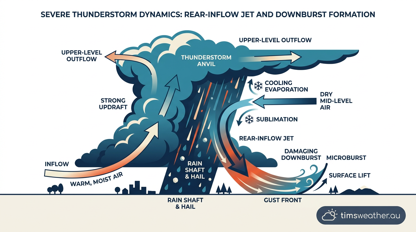
The defining feature of a bowed storm structure is the development of a rear-inflow jet. As a convective storm line matures and tilts backward over its own cold pool, a vast area of buoyant air is carried into the upper atmosphere. Beneath this rising, tilted updraft plume, a pocket of relatively low atmospheric pressure develops in the mid-levels of the troposphere.
This mid-level pressure deficit acts as a vacuum, drawing drier, cooler air into the back of the storm system. Educational training modules provided by major weather agencies note that as this air enters the storm, precipitation falls into it and evaporates. This evaporative cooling makes the incoming air mass heavier, causing it to accelerate downward toward the surface.
When this descending jet of air strikes the ground behind the leading edge of the storm, it spreads forward horizontally, pushing the squall line ahead of it. On radar, this process often reveals a rear-inflow notch, a channel of weaker reflectivity cutting into the back of the storm where the dry air is descending. This notch is a primary indicator for local storm spotters that a strong jet is active and severe straight-line winds are imminent.
What is a rear-inflow jet in a bow echo?
A rear-inflow jet is a fast-moving current of mid-level air that enters a storm system from behind, driving the centre of the storm line forward. As this dry air enters the rain shaft, it cools, becomes denser, and plummets toward the surface. This high-speed downdraft hits the ground and surges forward, strengthening the bowing radar signature and dramatically increasing the risk of destructive winds.
Book-end vortices and atmospheric dynamics
As the rear-inflow jet pushes the central portion of the squall line forward, the edges of the bowed segment experience intense localised wind shear. This differential movement, where the middle is fast and the edges are slower, forces the ends of the line to rotate, creating features known as book-end vortices. Early in their formation, both northern cyclonic and southern anticyclonic line-end vortices are typically of comparable strength.
These vortices act like structural anchors for the storm. They help draw additional mid-level air into the rear of the system, further strengthening the rear-inflow jet in a self-sustaining feedback loop. Over time, the Coriolis effect influences these vortices. In the Northern Hemisphere, the northern cyclonic vortex typically becomes dominant, while the southern vortex weakens. In Australia and the Southern Hemisphere, the southern cyclonic vortex usually becomes the dominant feature.
The presence of strong book-end vortices directly impacts the straight-line wind intensity near the apex. The dominant, cyclonically rotating vortex presents a separate severe weather hazard: it can support the development of brief, spin-up tornadoes embedded within the heavy rain, complicating the safety protocols for severe convective wind events.
Distinguishing bow echoes from supercell storms on radar
Modern meteorology relies heavily on Doppler radar and dual-polarisation imagery to interpret storm structures and issue timely warnings. While exploring the types of severe thunderstorms in Australia, meteorologists must quickly distinguish between a rotating supercell and a bowing line, as the damage patterns and warning lead times differ greatly.
A supercell is characterised by a deep, persistent rotating updraft called a mesocyclone, often presenting with a hook echo on radar reflectivity. In contrast, a bow echo presents as a solid line of intense reflectivity that bulges outward. While supercells are isolated discrete systems, bow echoes represent an organised convective structure spread across a broader front.
Using velocity products to map the inbound and outbound winds, forecasters can see the rear-inflow jet as a broad swath of intense wind pushing directly behind the apex of the bow. If trees or structures are destroyed by the straight-line winds, dual-pol products like Correlation Coefficient (CC) may occasionally show a debris signature, though this is less common in straight-line wind events than in tight tornadic circulations.
| Feature | Linear Squall Line | Bow Echo | Supercell |
|---|---|---|---|
| Radar Shape | Straight or gently curving line | Distinct outward-bulging crescent | Isolated cellular structure, often hooked |
| Primary Threat | Heavy rain, moderate wind gusts | Destructive straight-line winds | Large hail, strong tornadoes |
| Wind Mechanism | Broad outflow boundary | Intense rear-inflow jet | Rotating mesocyclone downdrafts |
| Lifespan | Hours to days | 3 to 6 hours (longer if a derecho) | 1 to 4 hours |
Wind damage and derecho evolution
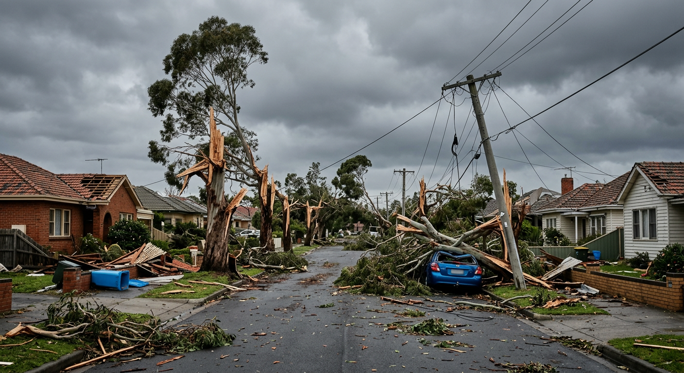
The damage patterns left behind by a bow echo are frequently compared to tropical cyclone landfalls, though the mechanics are entirely different. While a cyclone batters a coastline with rotational winds over many hours, a bow echo delivers a short, violent burst of straight-line winds that may only last five to fifteen minutes at any single location. These gales can easily snap trees, tear roofs off homes, and bring down wide expanses of power infrastructure.
In extreme cases, a well-organised bow echo can evolve into a derecho. A derecho is defined as a widespread, long-lived wind storm that is associated with a band of rapidly moving showers or thunderstorms. Studying how do derechos form helps clarify why they are so dangerous: by standard definitions from the National Oceanic and Atmospheric Administration, a derecho must produce a damage path of at least 386 kilometres (240 miles) and feature wind gusts reaching up to 209 km/h (130 mph).
Notable international case studies highlight the severity of these events. The 21 August 2007 northeastern Poland bow echo caused vast forestry destruction across the region, while the 10 August 2020 Iowa derecho produced destructive peak gusts estimated at 225 km/h (140 mph), levelling millions of hectares of crops and causing billions in damage.
Are bow echoes more dangerous than tornadoes?
Bow echoes and tornadoes present different types of danger. A tornado concentrates extreme rotational winds into a very narrow path, often causing catastrophic, total destruction to the specific homes it hits. A bow echo produces straight-line winds that are usually less intense than a severe tornado, but they impact a vastly larger area. Because a bow echo can sweep across entire cities simultaneously, the cumulative damage and total number of people affected often exceed that of an isolated tornado.
Regional impacts and Australian severe wind events
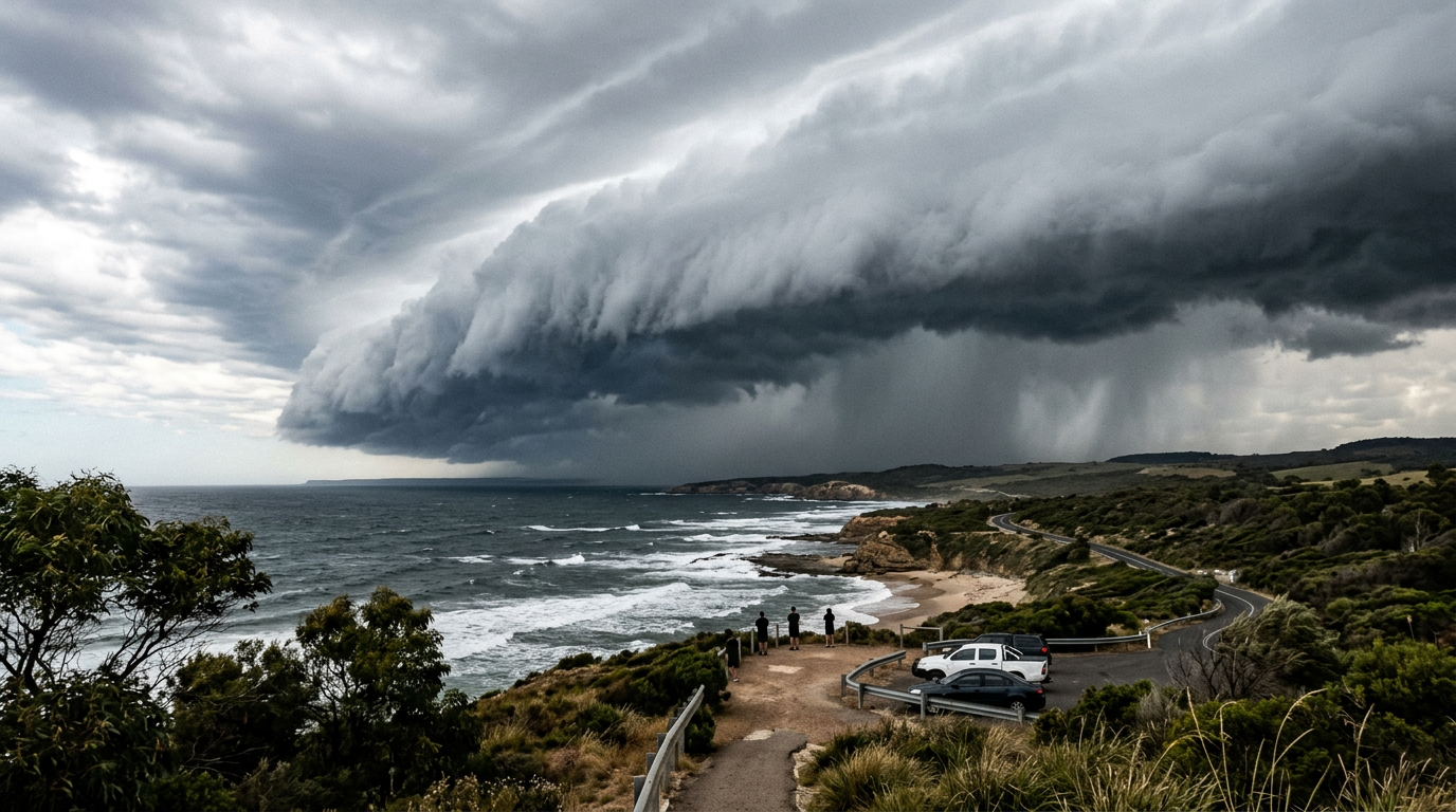
While the terminology 'derecho' is less commonly used by the Bureau of Meteorology (BOM) in public warnings, the underlying physics of bow echoes frequently impact the Australian continent. Local meteorologists track these systems through severe weather guidance, focusing on the potential for destructive wind gusts. Observing how squall line formation occurs across the country reveals distinct regional patterns.
Subtropical squall lines in South East Queensland during summer storm seasons are prime candidates for bow echo development. The interaction between the humid coastal air mass and cooler, drier air moving over the Great Dividing Range creates immense thermodynamic instability. Events like the November 2020 South East Queensland severe weather outbreaks and the intense 2020 Sydney 'Gabba' storm showcase how quickly a linear system can bow out as the cold pool surges into the moist coastal air.
Further north, severe wind events affecting the Northern Territory's Top End during the pre-monsoon 'build-up' (typically October to December) routinely feature bow echo signatures. Fast-moving systems, known locally as 'Hector' or simply severe dry-season squalls, march westward across the coast, bringing sudden, violent wind gusts that capsize small boats and bring down old trees. The BOM radar interpretation guide for local storm spotters emphasises watching for the telltale rear-inflow notch on the Darwin radar during these pre-monsoon events. Monitoring how squall lines Australia behave provides vital warning time for communities in the path of these intense wind events.
What wind speeds are associated with bow echoes in Australia?
In Australia, bow echoes frequently produce destructive wind gusts exceeding 90 km/h, which is the Bureau of Meteorology's threshold for severe thunderstorm warnings. During highly organised events, peak wind gusts can reach between 120 km/h and 160 km/h, comparable to a Category 2 or 3 tropical cyclone, causing significant damage to roofs, powerlines, and vegetation.
Frequently asked questions
Bow echoes form when a line of thunderstorms strengthens and a rear-inflow jet pushes faster air into the back of the storm. This causes the middle of the line to bulge forward on radar. This distinct bow shape typically indicates damaging straight-line winds and occasionally brief tornadoes.
Source: weather.gov
Further reading and resources
Explore trusted articles, books, videos and other resources to go deeper on this topic.
weather.govReference
Squall Line/Bow Echo/QLCS
Background reference on How Do Bow Echoes Form? The Complete Meteorological Guide from weather.gov.
en.wikipedia.orgReference
Bow echo
Background reference on How Do Bow Echoes Form? The Complete Meteorological Guide from en.wikipedia.org.
noaa.govReference
Bow Echoes
Background reference on How Do Bow Echoes Form? The Complete Meteorological Guide from noaa.gov.
courses.ems.psu.eduReference
Squall Lines, Derechos, and Bow Echoes - EMS Online Courses
Background reference on How Do Bow Echoes Form? The Complete Meteorological Guide from courses.ems.psu.edu.
stratusdeck.co.ukArticle
Bow echoes and derechos
In-depth coverage on How Do Bow Echoes Form? The Complete Meteorological Guide from stratusdeck.co.uk.
journals.ametsoc.orgArticle
Radar and Damage Analysis of Severe Bow Echoes ...
In-depth coverage on How Do Bow Echoes Form? The Complete Meteorological Guide from journals.ametsoc.org.
ecoflow.comArticle
Understanding Squall Line, Bow Echo & QLCS in 2026
In-depth coverage on How Do Bow Echoes Form? The Complete Meteorological Guide from ecoflow.com.
mhwm.plArticle
Derecho radar analysis of August 11, 2017
In-depth coverage on How Do Bow Echoes Form? The Complete Meteorological Guide from mhwm.pl.
Planning weeks ahead?
Check Australia's long-range seasonal outlook for rainfall, temperature and the climate drivers (ENSO, IOD, SAM, MJO) shaping the next three months.
View Australia's Seasonal Weather Forecast