
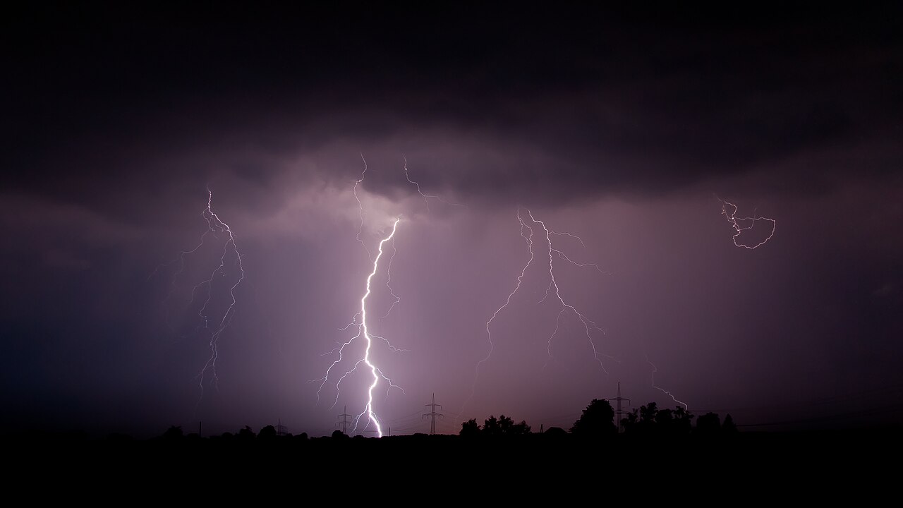
How do derechos form? These intense windstorms develop when a series of downburst clusters merge within a fast-moving mesoscale convective system. As a severe thunderstorm squall line accelerates, strong downdrafts and a powerful rear inflow jet push devastating straight-line winds to the surface, causing widespread damage over hundreds of kilometres.
Key takeaways
Derechos require a continuous or intermittent damage path of at least 400 kilometres and wind gusts of at least 93 km/h along most of their length to meet formal meteorological criteria.
They are driven by a self-sustaining feedback loop between a rain-cooled surface cold pool and a strong low-level wind jet.
Meteorologists identify these severe systems on radar by spotting a bow echo, where intense internal winds push the storm line outward.
Unlike the rotational damage of tornadoes, derechos produce widespread straight-line wind damage that resembles a broad carpet of destruction.
The meteorological definition of a derecho
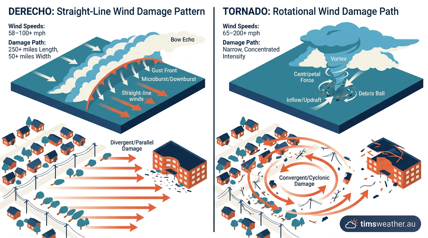
Infographic showing how do derechos form straight-line wind damage compared to rotational tornado damage.
While isolated thunderstorms frequently produce brief bursts of high wind, a derecho is an entirely different scale of weather event. The term was coined in 1888 by Gustavus Hinrichs to describe widespread, long-lived straight-line windstorms associated with a fast-moving band of severe showers or thunderstorms. Today, meteorologists look for specific spatial and intensity markers before applying the classification. The modern standard relies heavily on the foundational Johns and Hirt (1987) criteria, which stipulate that a convective windstorm must produce a continuous or intermittently continuous damage path at least 400 kilometres long.
Along this extensive path, surface wind gusts must frequently exceed 93 km/h. To qualify as a true derecho event, the system must include embedded severe gusts of at least 93 km/h (58 mph) along most of its length. The American Meteorological Society Glossary of Meteorology defines it as a widespread, convectively induced straight-line windstorm, maintaining these strict parameters to distinguish it from ordinary, short-lived squall lines. Recent atmospheric science research published in 2025 has proposed a stricter, process-based definition requiring a windstorm to arise specifically from a cold pool-driven mesoscale convective system.
Watch on YouTube of a Derecho approaching
Progressive versus serial systems
Meteorologists divide these destructive windstorms into two primary classifications: progressive and serial. Progressive derechos are typically fast-moving, warm-season events that track along a relatively stationary weather boundary. They are relatively narrow but pack an incredibly concentrated punch along their leading edge.
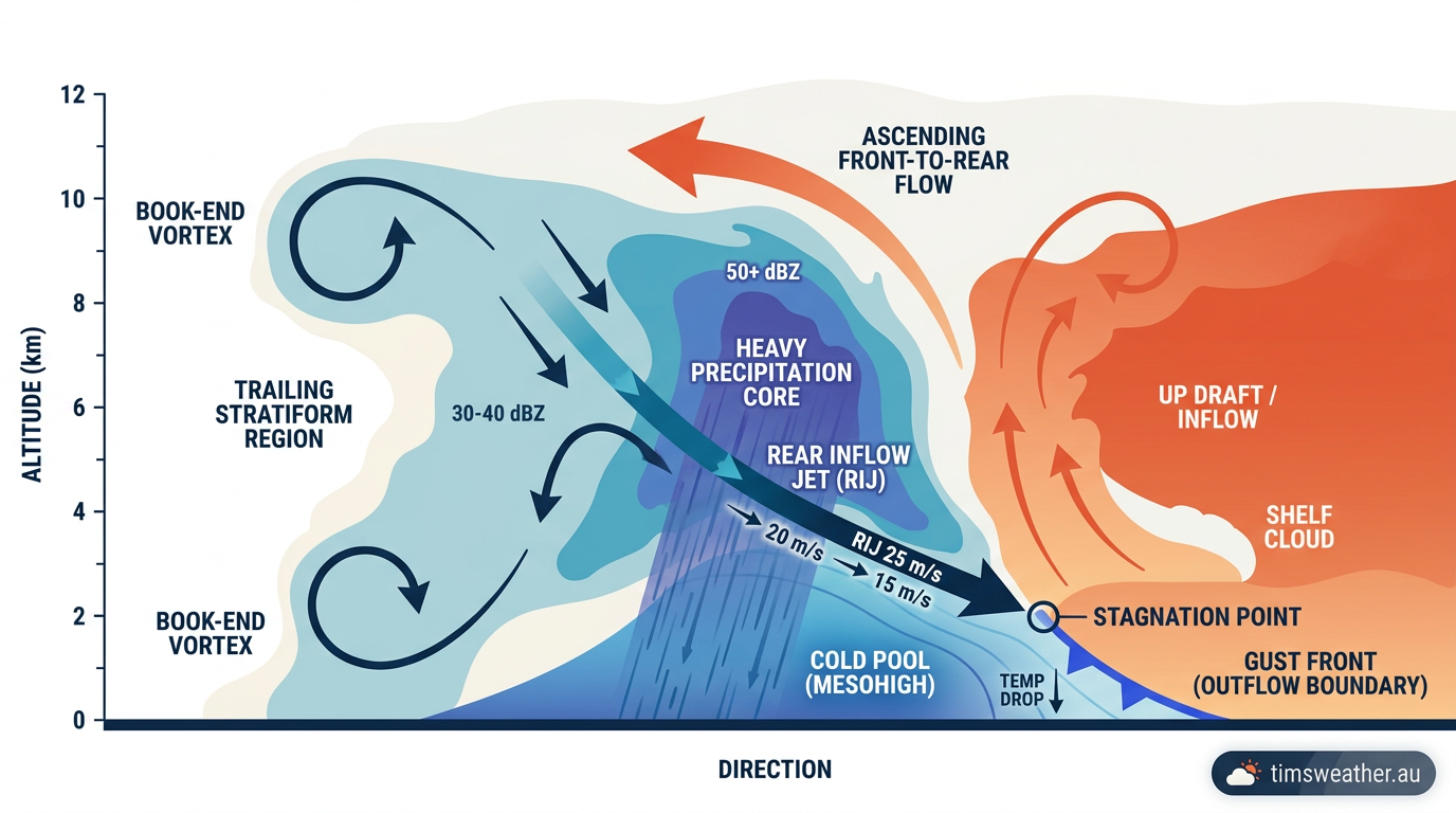
Cross-section diagram illustrating bow echo formation and the mechanics of a rear inflow jet.
Serial derechos are usually associated with powerful, large-scale low-pressure systems during the cooler months. They often feature multiple bowing segments embedded along a massive squall line that can sweep across multiple states or territories, delivering wave after wave of damaging gusts over a broad geographic area.
What is the difference between a derecho and a tornado?
A derecho produces widespread straight-line wind damage across a broad and continuous front, whereas a tornado generates tightly rotating winds confined to a narrow path. While both phenomena originate from severe thunderstorms and cause immense destruction, straight-line winds push debris in a single direction rather than twisting or lifting it cyclonically.
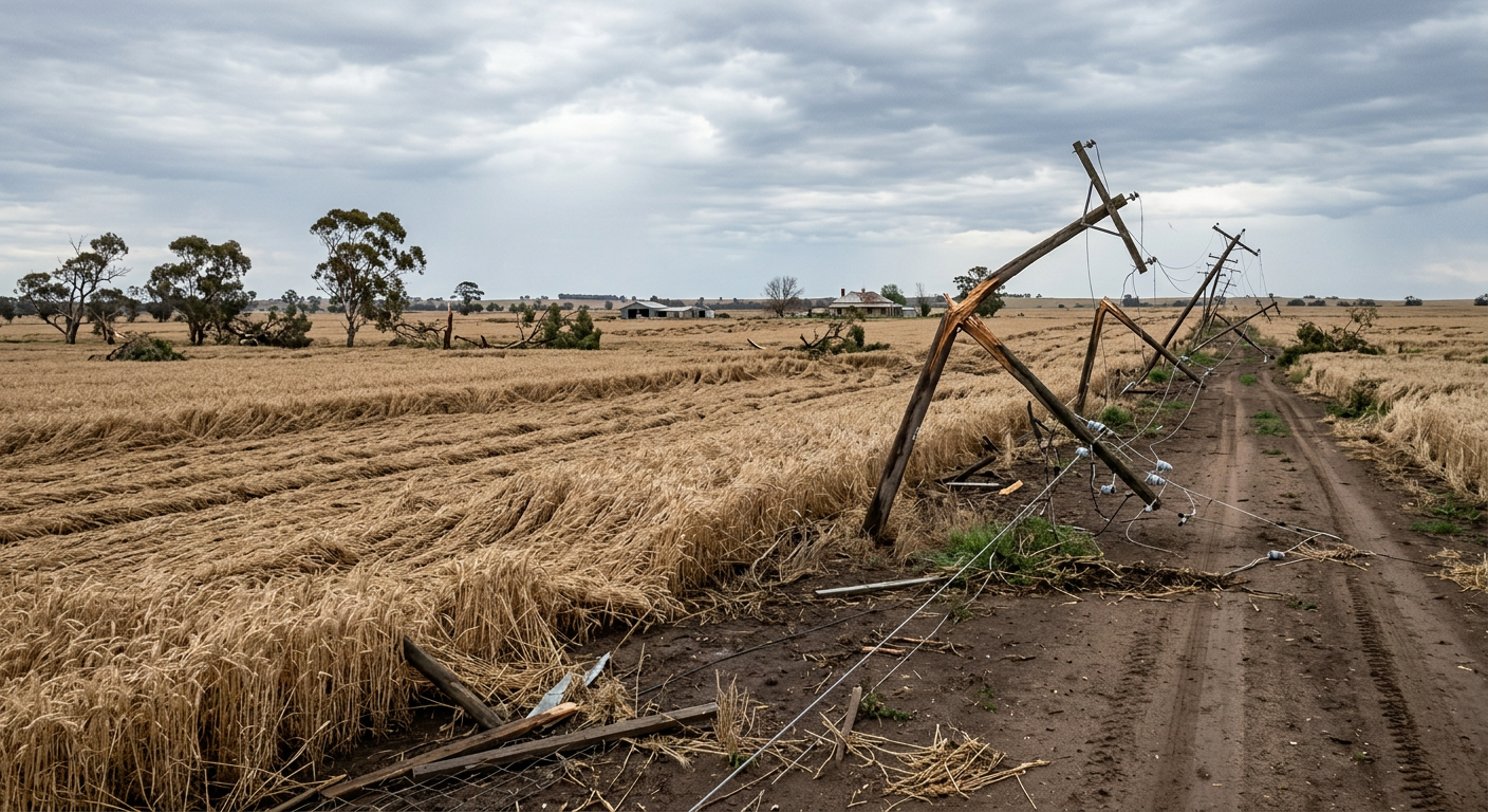
Widespread straight-line wind damage across a rural sector caused by a fast-moving convective windstorm.
As detailed in National Weather Service severe weather definitions, a convective windstorm leaves a wide carpet of damage that can span dozens of kilometres across, while tornado damage tracks rarely exceed a few kilometres in width. Surveyors inspecting the aftermath will typically see trees blown down facing the same direction, confirming straight-line wind damage.
How do derechos form? The atmospheric mechanics
To understand how do derechos form, you must look beyond isolated storm cells and examine how entire storm clusters interact and sustain themselves over many hours. The process begins with extreme thermodynamic instability. During the warmer months, intense solar heating warms the ground, which in turn heats the moisture-laden air immediately above it. This creates exceptionally high Convective Available Potential Energy (CAPE). When a lifting mechanism, such as a subtle atmospheric trough or an advancing cold front, forces this buoyant air upward, rapid condensation occurs. This initial stage dictates exactly how do cumulonimbus clouds form and mature into severe towering thunderstorms.
The role of vertical wind shear
As these individual cells grow, they begin to merge. For a long-track windstorm to develop, there must be moderate to strong vertical wind shear in the atmosphere. Wind shear occurs when wind speed or direction changes rapidly with height. This shear causes the main storm updrafts to tilt backward, preventing heavy falling rain from choking off the warm surface inflow.
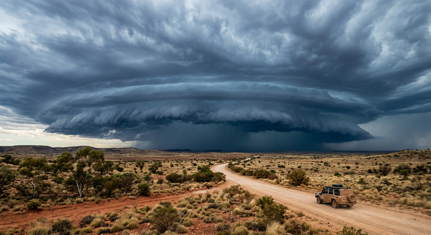
A threatening shelf cloud leading a severe thunderstorm squall line across the Australian outback.
This tilting allows a massive, unified storm structure to develop. The system then reaches a critical phase where mesoscale convective systems form, allowing the entire cluster to act as a single, organised weather engine. Without vertical wind shear, the thunderstorm would simply rain into its own updraft and collapse within an hour.
Downburst clusters and cold pool dynamics
The true power output of a widespread windstorm is driven by the downburst cluster. As precipitation falls through drier air in the mid-levels of the atmosphere, some of the rain and ice evaporates or sublimates. This phase change absorbs latent heat, drastically cooling the surrounding air. Because cold air is denser than warm air, it accelerates toward the surface as a powerful downburst.
When this descending air hits the ground, it spreads out rapidly, creating a gust front. If multiple downbursts merge, the resulting cold pool acts like an atmospheric snowplough, aggressively lifting the warm, moist air ahead of the storm into the updraft. This technical feedback loop between the advancing cold pool and the unstable air ahead is what makes the system self-sustaining, a process regularly highlighted in recent EarthSky meteorological summaries. This continuous regeneration loop allows the storm to propagate forward at extreme speeds, sometimes exceeding 100 km/h over open terrain.
The anatomy of a convective windstorm
The internal structure of a mature convective windstorm is highly complex. The meteorology of these systems reveals a continuous transfer of momentum from the middle atmosphere down to the surface. As the cold pool deepens and accelerates forward, it creates an area of low pressure just behind the main line of convective updrafts. This pressure deficit draws in a concentrated stream of dry, fast-moving air from the rear of the storm complex.
What triggers a bow echo formation?
A bow echo formation is triggered when a rear inflow jet descends toward the surface, pushing the central portion of a squall line forward faster than its outer edges. This intense internal momentum causes the radar signature to bulge outward into a distinct arch or bow shape, signalling the presence of highly destructive winds at the apex.
Identifying these massive storm clouds on radar involves looking for this characteristic apex of a bow echo. The winds at the apex are often the most severe, directly translating the speed of the mid-level jet into ground-level devastation. At the extreme ends of the bow, the Coriolis Effect and localised wind shear can cause bookend vortices to form. The northern vortex in the Southern Hemisphere often rotates cyclonically, occasionally producing brief, weak tornadoes that add further complexity to the gust front propagation.
The rear inflow jet mechanism
The role of the rear inflow jet is essential to the storm's survival. Without it, the storm line would eventually outrun its own cold pool and collapse. As described in educational materials from NOAA, the jet effectively feeds dry mid-level air directly into the storm's downdrafts.
This steady supply of dry air enhances the evaporative cooling process and maintains the intense density of the cold pool. This specific mechanism explains exactly how squall line formation occurs and why certain lines evolve into long-track disasters rather than dissipating quickly after a brief period of heavy rainfall.
Derecho vs tropical cyclone: Understanding the differences
A common point of confusion is differentiating between sudden, linear convective windstorms and large, rotational synoptic systems. While both deliver devastating winds and widespread power outages, their physical structures, lifespans, and formation triggers are entirely distinct. How how do tropical cyclones form highlights these differences clearly. Cyclones rely on the steady release of latent heat extracted from warm ocean waters over several days, whereas widespread damaging straight-line winds are driven by terrestrial heat, extreme atmospheric instability, and rapid cold pool dynamics over a matter of hours.
How fast are derecho wind speeds?
Derecho wind speeds must be at least 93 km/h to meet the formal classification, but severe events routinely generate gusts between 120 km/h and 160 km/h. According to NASA thunderstorm records, extreme straight-line winds within a storm's apex can exceed 200 km/h, rivalling the destructive force of an intense tropical cyclone or a strong, localised tornado.
Feature | Derecho | Tropical Cyclone |
|---|---|---|
Formation Trigger | High CAPE, vertical wind shear, and merging downburst clusters over land. | Warm sea surface temperatures and low vertical wind shear over ocean basins. |
Wind Type | Straight-line winds spreading outward violently from a gust front. | Rotational winds circulating cyclonically around a central low-pressure eye. |
Duration and Speed | Extremely fast-moving (often 80+ km/h), lasting several hours to a day. | Slow-moving system (10 to 30 km/h), lasting several days to weeks. |
Primary Hazard Zone | Concentrated along the leading edge (apex) of the advancing bow echo. | Concentrated within the eyewall immediately surrounding the calm centre. |
Global windstorms and Australian derecho events
When studying severe weather, many climatologists reference the North American Corn Belt where the classic conditions of high heat, intense humidity, and strong upper-level winds align perfectly during summer. A globally significant example is the catastrophic 10 August 2020 Midwest derecho, which caused historic agricultural and infrastructure damage across Iowa and surrounding states. Similarly, the 4–5 July 1999 Boundary Waters derecho uprooted millions of trees across the Upper Midwest. However, the exact same atmospheric physics apply globally wherever the right meteorological ingredients merge.
Can a derecho happen in Australia?
Yes, they can happen in Australia, though the Bureau of Meteorology (BOM) more commonly refers to them as severe inland squall lines or convective windstorms. The thermodynamic conditions required for long-track straight-line winds regularly develop across the Australian interior, particularly during the warmer months when deep surface troughs draw tropical moisture southward into highly unstable air masses.
Are derechos common in Australia? While formally classified events are rare in public weather warnings, the physical phenomenon occurs frequently. During the Northern Territory Build-up, immense heat and humidity over the Top End frequently trigger massive, highly organised squall lines. As these massive systems track inland, their intense downbursts generate sweeping dust storms and violent straight-line wind damage. Similar extreme wind events regularly strike The Kimberley region in Western Australia.
The impact of severe convective windstorms on Australian power grids and infrastructure can be profound. Remote WA mining operations often face these rapid-onset windstorms sweeping across the desert. Standard safety protocols require operators to shut down heavy machinery, secure loose equipment, and halt explosive blasting when radar shows an approaching bow echo. Distinguishing these violent events from other regional phenomena is critical for safety. For example, a convective windstorm is completely different from the Morning Glory clouds of the Gulf of Carpentaria or the Gully Winds in South Australia, which are driven by gravity waves and terrain channelling rather than thunderstorm downbursts.
A prominent recent example was the 2020 Sydney 'derecho-like' thunderstorm event. A massive squall line developed ahead of a strong cold front, producing widespread wind damage, downed trees, and major power outages across a vast swath of eastern New South Wales. For regional communities, understanding the approaching thunderstorm signs NSW residents can observe, such as a rapidly advancing shelf cloud, is vital. While Australia sees various types of severe thunderstorms in Australia, including those that lead to supercell thunderstorm formation, a mature bow echo poses the broadest risk to widespread agriculture and infrastructure due to its massive geographic footprint.
Rapid atmospheric pressure variations play a significant role in how these storms move. The intense cold pool creates a localised meso-high pressure area at the surface, while the warm updraft region features lower pressure. This steep pressure gradient forces the gust front forward violently. A clear grasp of high and low pressure systems Australia explained helps forecasters predict exactly where the broader synoptic boundaries will intersect with these volatile meso-scale pressure gradients.
Frequently asked questions
Derechos form when a large thunderstorm system organises into a fast-moving line. As strong downdrafts and a rear-inflow jet develop, they push damaging winds to the surface. This creates a long, continuous swath of straight-line wind damage that can stretch for hundreds of kilometres across the landscape.
Source: nesdis.noaa.gov
Further reading and resources
Explore trusted articles, books, videos and other resources to go deeper on this topic.
ebsco.comArticle
Derecho | Earth and Atmospheric Sciences
In-depth coverage on How Do Derechos Form? The Complete Guide to Convective Windstorms from ebsco.com.
nesdis.noaa.govReference
What Is a Derecho? | NESDIS - NOAA
Background reference on How Do Derechos Form? The Complete Guide to Convective Windstorms from nesdis.noaa.gov.
eos.orgArticle
What Drives Derechos? The First Derecho Archive Could Help ...
In-depth coverage on How Do Derechos Form? The Complete Guide to Convective Windstorms from eos.org.
weather.govReference
Derecho
Background reference on How Do Derechos Form? The Complete Guide to Convective Windstorms from weather.gov.
en.wikipedia.orgReference
Derecho
Background reference on How Do Derechos Form? The Complete Guide to Convective Windstorms from en.wikipedia.org.
undrr.orgArticle
Derecho (MH0302) - UNDRR
In-depth coverage on How Do Derechos Form? The Complete Guide to Convective Windstorms from undrr.org.
repository.library.noaa.govReference
[PDF] A Historical Overview on the Science of Derechos
Background reference on How Do Derechos Form? The Complete Guide to Convective Windstorms from repository.library.noaa.gov.
hazards.colorado.eduReference
[PDF] Derecho Hazards in the United States Walker S. Ashley Climatology ...
Background reference on How Do Derechos Form? The Complete Guide to Convective Windstorms from hazards.colorado.edu.
noaa.govReference
Derechos | National Oceanic and Atmospheric Administration - NOAA
Background reference on How Do Derechos Form? The Complete Guide to Convective Windstorms from noaa.gov.
certifiedwaterandfire.comArticle
Derecho Storm: 3 Devastating Types Explained
In-depth coverage on How Do Derechos Form? The Complete Guide to Convective Windstorms from certifiedwaterandfire.com.
Planning weeks ahead?
Check Australia's long-range seasonal outlook for rainfall, temperature and the climate drivers (ENSO, IOD, SAM, MJO) shaping the next three months.
View Australia's Seasonal Weather Forecast