
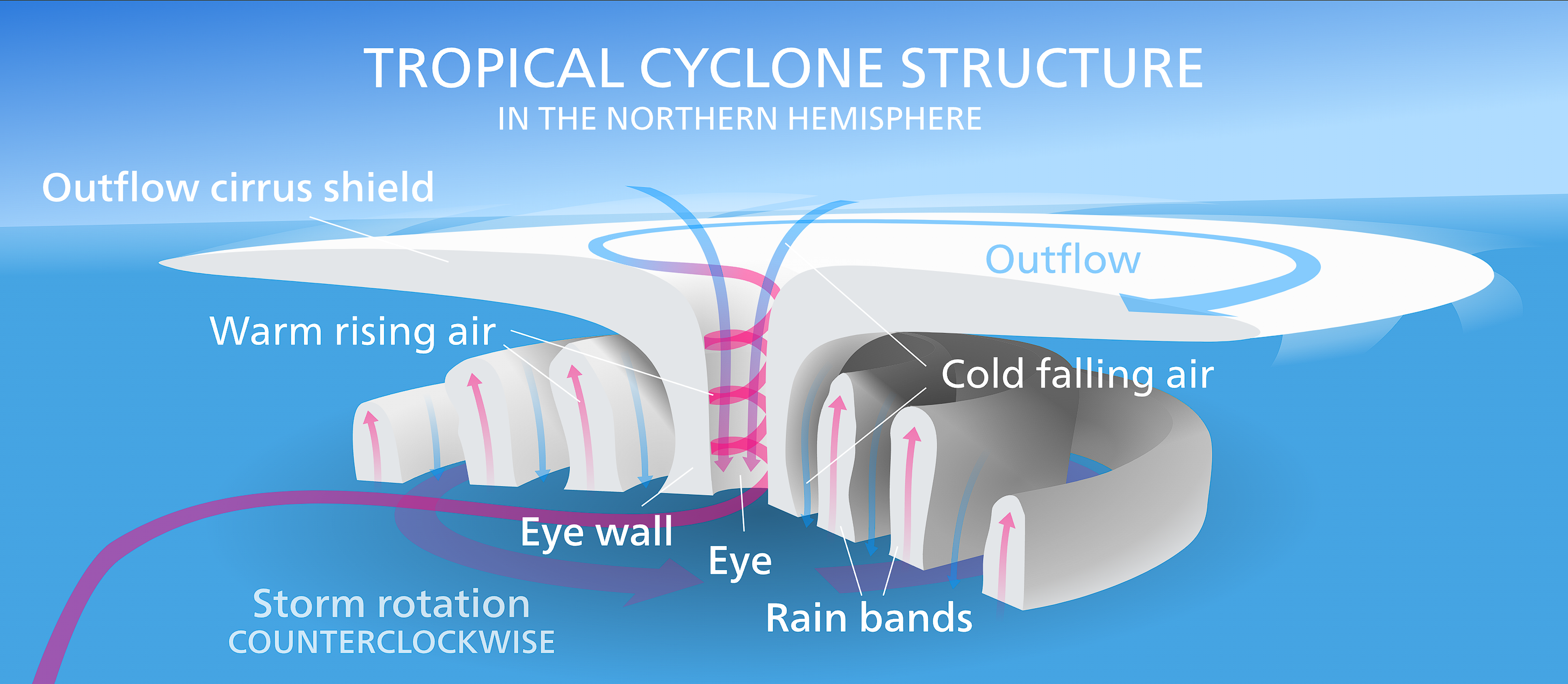
How do tropical cyclones form? These systems originate over warm tropical waters, typically at least 26.5 degrees Celsius, where high humidity and atmospheric instability allow moist air to rise. Combined with low vertical wind shear and the Coriolis effect, these conditions create a rotating low-pressure system that intensifies through latent heat release.
Key takeaways
Tropical cyclones require ocean temperatures of at least 26.5 degrees Celsius down to a depth of 50 metres to generate sufficient thermal energy.
The Coriolis force provides the necessary spin, causing systems to deflect and rotate clockwise in the Southern Hemisphere and counter-clockwise in the Northern Hemisphere.
Strong vertical wind shear can tear a developing storm apart by separating its heat source from its mid-level circulation.
Meteorological agencies classify these severe weather events differently based on their global basin, using frameworks like the Australian Category Scale or the Saffir-Simpson scale.
Warm anomalies and background climate states, such as the El Niño-Southern Oscillation, heavily influence where and how frequently genesis occurs.
The science of how do tropical cyclones form
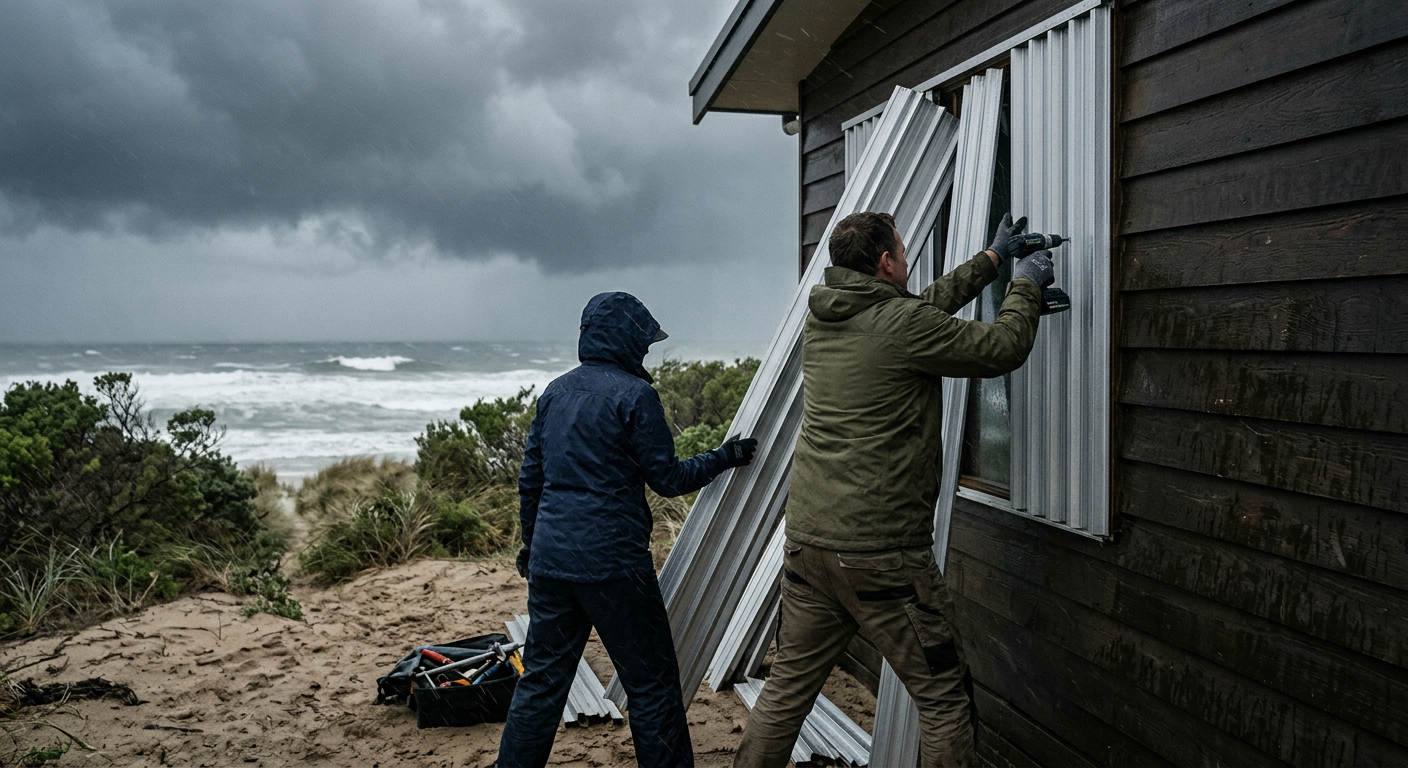
People preparing their home with strong shutters ahead of an approaching severe weather system.
Meteorologists with a degree in atmospheric science learn early on that tropical cyclones are highly structured weather machines requiring a specific and fragile alignment of atmospheric and oceanic conditions.
In 1948, meteorologist Eric Palmen published a foundational study demonstrating that these massive storms require substantial thermal energy from the ocean surface to overcome atmospheric resistance.
The World Meteorological Organization outlines several non-negotiable requirements for genesis. Without all of these elements present simultaneously, a loose cluster of thunderstorms will simply rain itself out rather than evolving into a severe weather event.
How these requirements begins with the basic principles of thermodynamics. A tropical cyclone acts essentially as a large-scale Carnot heat engine. It draws thermal energy from the warm ocean surface, converts that heat into kinetic energy (wind), and expels the excess heat into the extreme cold of the upper troposphere. If any part of this engine is disrupted, the system will fail to organise.
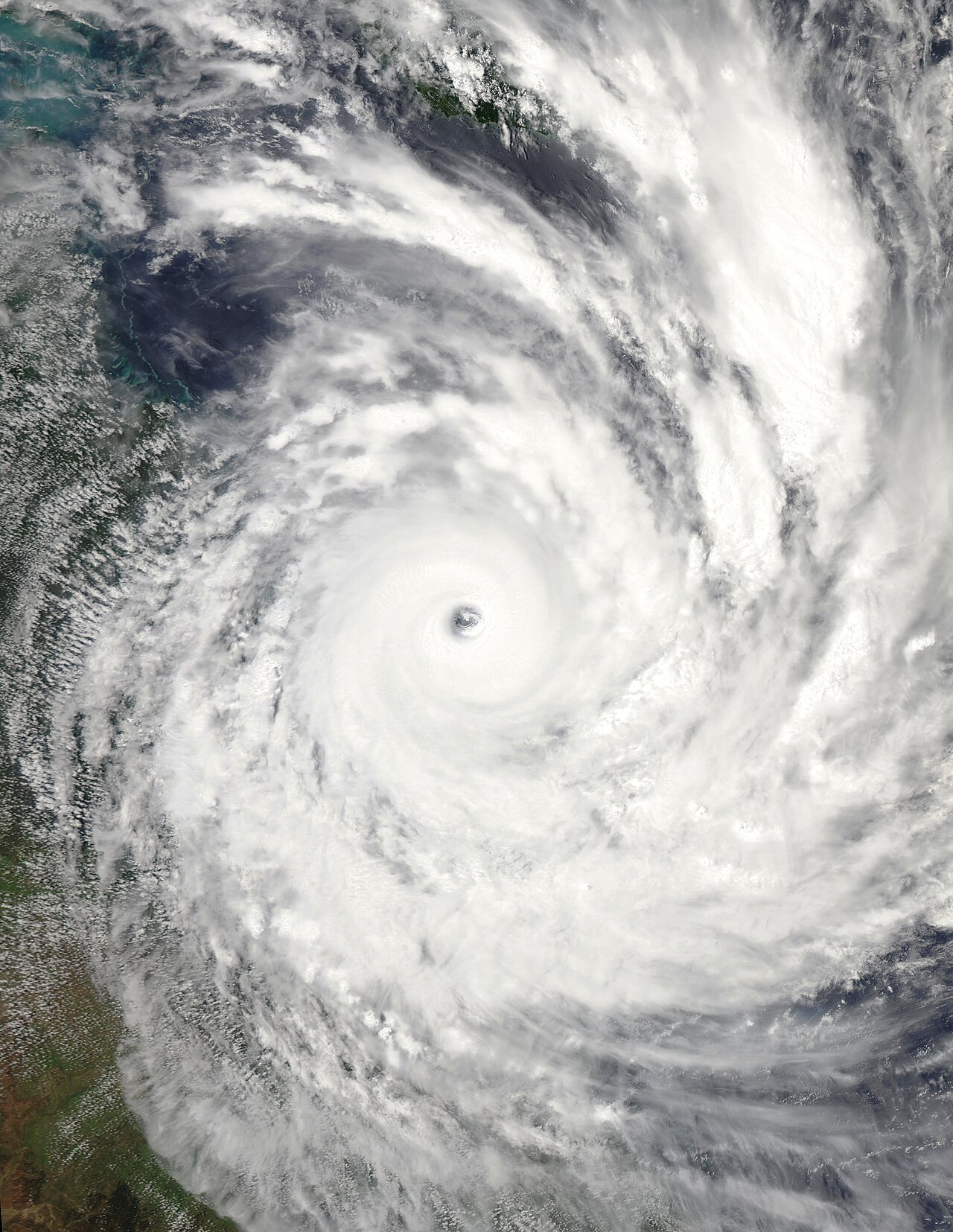
Cyclone Yasi approaching Queensland near peak intensity on 2 February 2011. By NASA/Aqua-MODIS - EOSDIS Worldview, Public Domain, https://commons.wikimedia.org/w/index.php?curid=127394419
What are the 6 conditions for a tropical cyclone to form?
The six conditions required for formation are: ocean waters of at least 26.5 degrees Celsius, a deep layer of warm water extending approximately 50 to 60 metres below the surface, an atmosphere that cools rapidly with height to support continuous thunderstorm development, high humidity in the lower and middle troposphere, low vertical wind shear, and sufficient distance from the equator (typically at least 5 degrees of latitude) for the Coriolis effect to initiate rotation.
Why 26.5°C is the Magic Number for Australian Waters
The requirement for sea surface temperatures to reach 26.5 degrees Celsius is a strictly physical threshold. At this temperature, the evaporation rate of ocean water increases exponentially.
This high rate of evaporation is necessary to supply the lower atmosphere with massive quantities of water vapour, which acts as the primary fuel source for the developing storm. In Australian waters, particularly across the northern tropics during summer, sea surface temperatures frequently exceed this baseline, often sitting between 28 and 30 degrees Celsius.
However, surface warmth alone is insufficient. The warm layer must extend deeply into the water column. As a tropical low begins to spin, the surface winds agitate the ocean, creating large waves and strong turbulent mixing. If the warm water layer is shallow, this mixing will bring colder water from the depths up to the surface. This sudden drop in surface temperature would immediately cut off the storm's energy supply, causing the system to decay before it can mature.
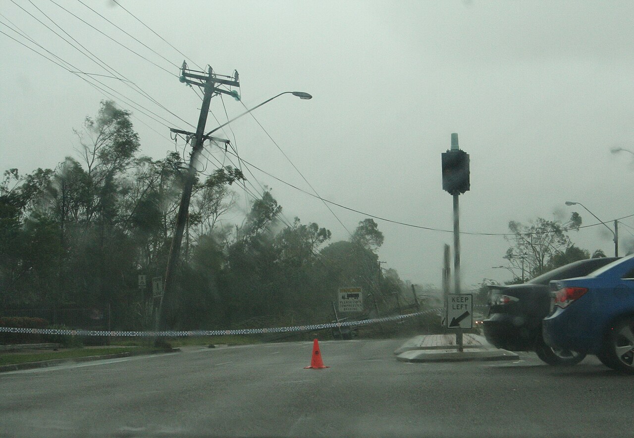
Devastation from a tropical cyclone: downed power lines and bent trees showcase the powerful forces generated by these meteorological phenomena. By Rob and Stephanie Levy from Townsville, Australia - Powerlines down across Hugh Street, CC BY 2.0, https://commons.wikimedia.org/w/index.php?curid=12893718
At what water temperature do tropical cyclones begin to form?
Tropical cyclones begin to form when water temperatures hit 26.5 degrees Celsius (80 degrees Fahrenheit). This heat must be sustained over a wide geographical area to allow a tropical disturbance enough time to gather moisture, organise its convection currents, and lower the surface barometric pressure enough to establish a closed circulation.
The lifecycle of a tropical cyclone
The transformation from a benign cluster of clouds into a catastrophic weather event happens in distinct, measurable stages. It begins with a pre-existing atmospheric disturbance. These disturbances often manifest as waves of low pressure moving through the tropical atmosphere. If conditions remain favourable, the disturbance gathers organisation. To see how do tropical depressions form, meteorologists monitor surface pressure maps and satellite imagery for early signs of a closed circulation.
As the thunderstorms persist, surface barometric pressure drops. The system is unorganised but clearly spinning. The relevant Tropical Cyclone Warning Centre will monitor the system closely, issuing early forecasts to marine and coastal communities to allow ample preparation time.
From Tropical Low to Category 5: The Intensification Timeline
The timeline of intensification varies wildly depending on the environment. Some systems meander as weak tropical lows for weeks, while others undergo rapid intensification, jumping multiple categories in under 24 hours. Once sustained winds reach 63 km/h (34 knots), the system is officially upgraded to a tropical cyclone and receives a name from the regional meteorological authority, such as the Bureau of Meteorology.
The central pressure drops further, the circulation tightens, and heavy rain bands begin wrapping around the centre. If intensification continues unabated, the system will eventually develop a clear, calm eye surrounded by an intensely powerful eyewall, reaching severe status with wind gusts exceeding 165 km/h. At the extreme upper limit, a Category 5 system represents the absolute peak of atmospheric energy conversion, capable of flattening solid structures and completely reshaping coastlines.
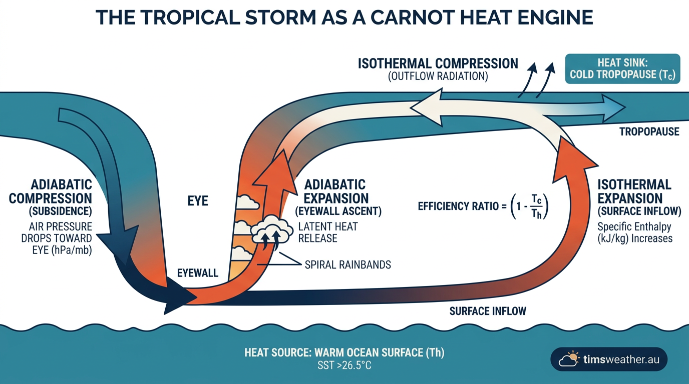
Infographic showing how latent heat release and convection currents drive tropical cyclone formation.
What is the difference between a tropical low and a tropical cyclone?
A tropical low is an initial stage of development characterised by a weak, unorganised low-pressure centre with sustained winds below 63 km/h. A tropical cyclone is a more advanced, highly organised system with a distinct closed circulation, visible spiral rain bands, and sustained surface winds of 63 km/h or greater.
Global basins and regional terminology
The fundamental mechanics of how these severe storms develop are identical worldwide, but the terminology changes depending on where the storm occurs. In the North Atlantic and northeast Pacific, these systems are called hurricanes. In the western North Pacific, they are known as typhoons. Across the South Pacific and Indian Ocean, they are referred to simply as tropical cyclones.
The timing of these events also varies significantly by basin. For instance, the Atlantic Ocean's hurricane season peaks from mid-August to late October (www.nationalgeographic.com), driven by the heating of the North Atlantic and the emergence of tropical waves off the African coast. In contrast, the Australian cyclone season runs from November to April, aligning with the Southern Hemisphere summer when regional ocean temperatures reach their maximum.
The Role of the Australian Monsoon in Cyclone Genesis
In the Australian region, genesis is strongly tied to the behaviour of the monsoon trough and the Intertropical Convergence Zone (ITCZ). The monsoon trough is a broad area of low pressure where the north-westerly monsoon winds from the equator meet the south-easterly trade winds. This collision forces warm, moist air upward, creating a permanent band of thunderstorms.
When atmospheric waves, such as Rossby waves or the Madden-Julian Oscillation (MJO), pass through the monsoon trough, they inject additional spin and moisture into the environment. This interaction frequently triggers the formation of a tropical low. The Bureau of Meteorology closely tracks the MJO, as its arrival over northern Australian waters drastically increases the probability of cyclone formation within a given fortnight.
The Coriolis Effect at Southern Latitudes explained
The Coriolis effect is an apparent force caused by the rotation of the Earth, and it is the sole reason these storms spin. Because the Earth is a sphere, the equator rotates faster than the poles. As air moves toward a low-pressure centre, this difference in rotational speed deflects the air from a straight path. Near the equator (between 0 and 5 degrees latitude), the Coriolis force is too weak to create a closed circulation, which is why cyclones rarely form directly on the equator.
Why do cyclones rotate clockwise in Australia?
Cyclones rotate clockwise in Australia because of the Coriolis effect in the Southern Hemisphere. As the central low pressure draws air inward, the Earth's rotation deflects these incoming winds to the left. This continuous leftward deflection around a central point results in a clockwise spinning vortex.
Atmospheric instability, latent heat and structural evolution
At its core, the fuel driving this massive engine is latent heat. When warm ocean water evaporates, it absorbs heat energy from the sea surface. As this invisible, moisture-laden air rises into the cooler atmosphere, it condenses back into liquid water droplets. How how do cumulonimbus clouds form helps explain this process, as towering clouds require massive amounts of condensation.
This condensation process releases the stored latent heat into the surrounding upper air. The added heat makes the air even less dense, causing it to rise faster and creating a powerful vacuum effect at the surface. This vacuum draws in more warm, moist air, accelerating the convection currents and causing the barometric pressure to plummet. As the system matures, this intense upward motion concentrates near the centre, leading to eye wall development.
The eyewall is a ring of spectacular, violent thunderstorms immediately surrounding the calm eye, containing the heaviest rainfall and the most destructive winds in the entire storm. If the storm undergoes an eyewall replacement cycle, an outer ring of thunderstorms may form and choke off the inner eye, temporarily weakening the storm before it broadens and re-intensifies.
How Wind Shear Dissipates Potential Systems
For latent heat to effectively lower the surface pressure, the thunderstorms must remain vertically stacked over the exact centre of the low-pressure area. This is where vertical wind shear becomes critical. Wind shear refers to a change in wind speed or direction with altitude. Low wind shear allows the storm to stand upright, concentrating the heat release directly above the surface circulation.
High vertical wind shear is extremely hostile to cyclone development. If high-altitude winds blow strongly across the top of the developing storm, they will literally push the thunderstorm tops away from the surface low-pressure centre. This tilts the vortex and separates the latent heat engine from the surface circulation. Without the continuous feedback loop of heat release aligned over the centre, the surface pressure rises, the winds weaken, and the potential system completely dissipates.
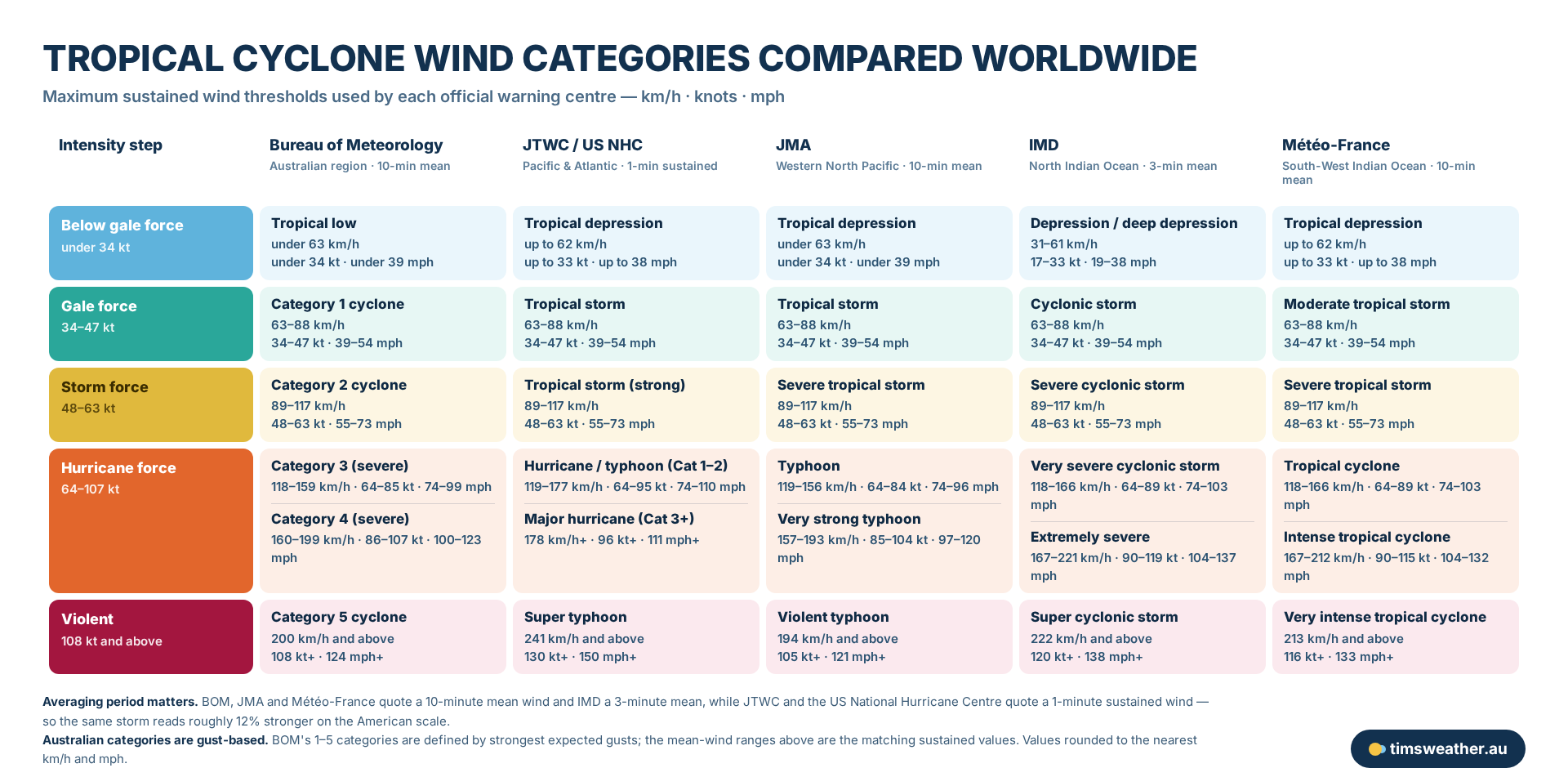
This chart compares global tropical cyclone wind categories and speeds, illustrating how these powerful weather systems are classified by meteorologists.
Regional hotspots and topography
Northern Australia is highly vulnerable to tropical cyclones because of its vast stretches of warm coastal waters. The Pilbara and Kimberley coasts in Western Australia are notorious breeding grounds. The shallow, sun-baked waters of the Arafura Sea and the Indian Ocean regularly exceed 29 degrees Celsius during mid-summer, providing exceptional fuel for rapid intensification. Storms forming in this region often grow into massive, severe systems before making landfall on the sparsely populated but highly industrialised coastline.
On the eastern seaboard, tropical cyclone formation Coral Sea dynamics are heavily influenced by the El Niño-Southern Oscillation. During a La Niña phase, warmer waters push toward the Australian coast, increasing the likelihood of cyclone genesis close to land. Conversely, El Niño events typically shift the focus of genesis further east into the Pacific Ocean.
Once a cyclone makes landfall, its survival depends largely on the terrain. The Great Dividing Range in eastern Australia acts as a massive physical barrier. As the system moves inland, it is starved of its oceanic moisture source. The rugged topography of the mountains induces frictional drag and shreds the lower-level circulation, causing the storm to rapidly decay into a rain depression. However, storms moving parallel to the coast can occasionally be sustained further south than expected by the East Australian Current, a persistent ribbon of warm tropical water flowing southward down the New South Wales coastline.
Comparing intensity scales: Saffir-Simpson vs the Australian Category Scale
Interpreting severe weather warnings requires knowing exactly which scale the local meteorological agency is using. Globally, the naming and categorisation conventions differ significantly, which can cause confusion when comparing storms across different regions.
Hurricanes are rated by categories on the Saffir-Simpson scale (www.nationalgeographic.com). This system measures the maximum sustained winds averaged over a 1-minute period. The scale ranges from Category 1 to Category 5 and is widely used by the National Hurricane Center and the Joint Typhoon Warning Center for storms in the Americas and parts of the Pacific.
In contrast, the Bureau of Meteorology uses the Australian Category Scale. This scale also ranges from Category 1 to Category 5, but it is based on maximum 3-second wind gusts rather than 1-minute sustained winds. Because gusts are always higher than sustained winds, a direct one-to-one numerical comparison between the two scales is not perfectly aligned, but the physical destruction potential remains similar at the highest thresholds.
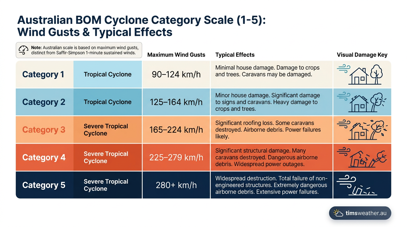
Chart comparing Australian Bureau of Meteorology cyclone categories and their corresponding wind speeds.
Australian Category Scale | Maximum 3-Second Gust (km/h) | Equivalent US Saffir-Simpson | Typical Damage Potential in Australia |
|---|---|---|---|
Category 1 | 90 to 125 km/h | Tropical Storm | Minimal house damage. Damage to some crops, trees and caravans. |
Category 2 | 125 to 164 km/h | Category 1 Hurricane | Minor house damage. Significant damage to signs, trees and caravans. |
Category 3 (Severe) | 165 to 224 km/h | Category 2 / 3 Hurricane | Some roof and structural damage. Power failures likely. |
Category 4 (Severe) | 225 to 279 km/h | Category 3 / 4 Hurricane | Significant roofing loss and structural damage. Dangerous airborne debris. |
Category 5 (Severe) | More than 280 km/h | Category 5 Hurricane | Extremely dangerous. Widespread destruction of buildings and infrastructure. |
Historical extremes and catastrophic impacts
By studying high and low pressure systems Australia explained in historical contexts, meteorologists can gauge the extreme physical limits of these severe storms. Global weather records provide a sobering look at what happens when environmental conditions perfectly align for explosive atmospheric growth.
Wind speeds can reach unimaginable velocities when vertical wind shear is virtually zero and sea surface temperatures are excessively high. In 2015, Hurricane Patricia had the strongest winds recorded, at 215 miles per hour (www.nationalgeographic.com) off the Pacific coast of Mexico. Closer to the Australian coast, Cyclone Yasi struck North Queensland in 2011 with wind gusts estimated at 285 km/h, causing immense agricultural and structural devastation.
While extreme wind receives significant attention, rainfall and water displacement are often far more lethal. Slow-moving systems can act like massive atmospheric rivers. In 2017, Hurricane Harvey dropped a record-breaking 51.8 inches of rain (www.nationalgeographic.com) over Texas, resulting in catastrophic inland flooding that overwhelmed urban infrastructure.
The oceanic water pushed ashore, known as the storm surge, is responsible for the vast majority of casualties globally. Storm surges can reach 20 feet (6 meters) high (www.nationalgeographic.com), acting like a sudden coastal tsunami that sweeps away everything in its path. Tragically, a third of the 1,200 deaths from Hurricane Katrina were caused by drowning (www.nationalgeographic.com) when the massive storm surge completely overwhelmed the levee defence systems in New Orleans in 2005.
How climate change affects cyclone frequency and intensity
Data stored in global archives provides researchers with a long-term view of storm behaviour. While the total number of tropical cyclones forming globally each year remains relatively stable, the proportion of those storms rapidly intensifying into severe categories is increasing.
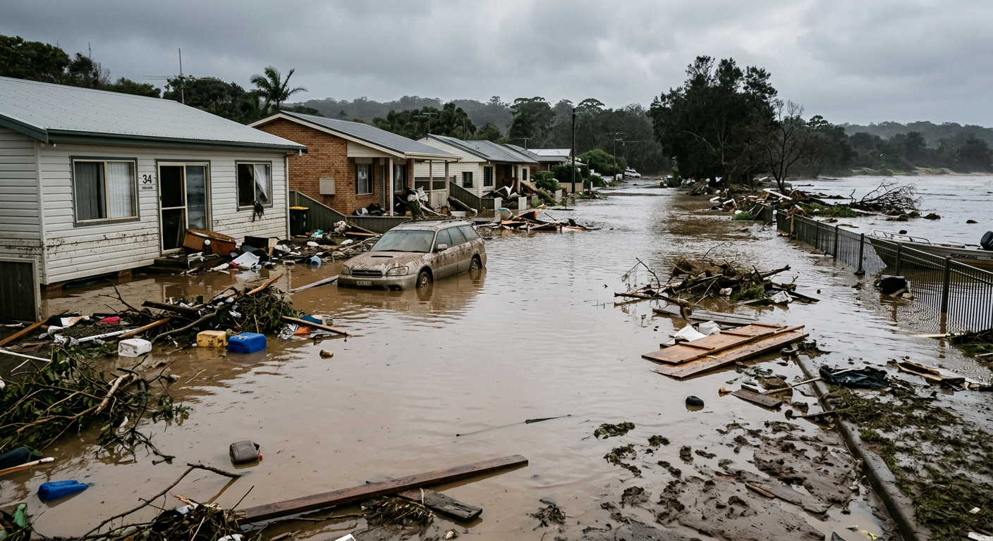
Severe flooding and structural damage in a coastal neighbourhood following a powerful storm surge.
This trend is strongly linked to rising sea surface temperatures. Warmer oceans provide a higher potential intensity limit for storms that do form. The critical 26.5 degree Celsius isotherm is extending deeper into the ocean column and further poleward. This means storms can draw on a much larger reservoir of latent heat without upwelling cold water to kill their momentum. As a result, storms like Cyclone Ita and others in recent decades have demonstrated rapid intensification cycles that consistently challenge forecasting models.
The clustering of severe events in hyperactive seasons also stretches emergency management resources. The 2018 hurricane season had 22 major hurricanes in under three months (www.nationalgeographic.com) across global basins. In the Atlantic alone in 2020, there were 30 named storms, with 14 developing into hurricanes (www.nationalgeographic.com), exhausting the standard naming list entirely and forcing agencies to adapt their operational procedures.
Also, warmer atmospheres physically hold more moisture. The Clausius-Clapeyron relation dictates that for every 1 degree Celsius of atmospheric warming, the air can hold approximately 7 percent more water vapour. This directly translates into substantially heavier rainfall rates during cyclone landfall, increasing the risk of severe flash flooding far beyond the immediate coastal impact zone.
Frequently asked questions
Tropical cyclones form when warm ocean water evaporates, providing heat and moisture to the atmosphere. This rising air creates thunderstorms around a low-pressure centre. As the system draws in more moist air, it strengthens and begins to rotate, eventually developing into a fully organised tropical cyclone.
Source: bom.gov.au
Further reading and resources
Explore trusted articles, books, videos and other resources to go deeper on this topic.
emergency.fsu.eduReference
Tropical Storms & Hurricanes: The Basics
Background reference on How Do Tropical Cyclones Form? The Complete Meteorological Guide from emergency.fsu.edu.
youtube.comVideo
Understanding tropical cyclones
Video coverage on How Do Tropical Cyclones Form? The Complete Meteorological Guide from youtube.com.
metoffice.gov.ukReference
Tropical cyclone facts
Background reference on How Do Tropical Cyclones Form? The Complete Meteorological Guide from metoffice.gov.uk.
en.wikipedia.orgReference
Tropical cyclone
Background reference on How Do Tropical Cyclones Form? The Complete Meteorological Guide from en.wikipedia.org.
metlink.orgArticle
Royal Meteorological Society 20. Tropical Cyclones
In-depth coverage on How Do Tropical Cyclones Form? The Complete Meteorological Guide from metlink.org.
ametsoc.orgArticle
Tropical Cyclone Forecasting in the United States
In-depth coverage on How Do Tropical Cyclones Form? The Complete Meteorological Guide from ametsoc.org.
met.nps.eduReference
Tropical-Cyclone Formation: Theory and Idealized mo
Background reference on How Do Tropical Cyclones Form? The Complete Meteorological Guide from met.nps.edu.
climatecentral.orgArticle
Extreme Weather Toolkit: Tropical Cyclones
In-depth coverage on How Do Tropical Cyclones Form? The Complete Meteorological Guide from climatecentral.org.
oceanservice.noaa.govReference
How do hurricanes form?
Background reference on How Do Tropical Cyclones Form? The Complete Meteorological Guide from oceanservice.noaa.gov.
scied.ucar.eduReference
How Hurricanes Form - UCAR Center for Science Education
Background reference on How Do Tropical Cyclones Form? The Complete Meteorological Guide from scied.ucar.edu.
Planning weeks ahead?
Check Australia's long-range seasonal outlook for rainfall, temperature and the climate drivers (ENSO, IOD, SAM, MJO) shaping the next three months.
View Australia's Seasonal Weather Forecast