
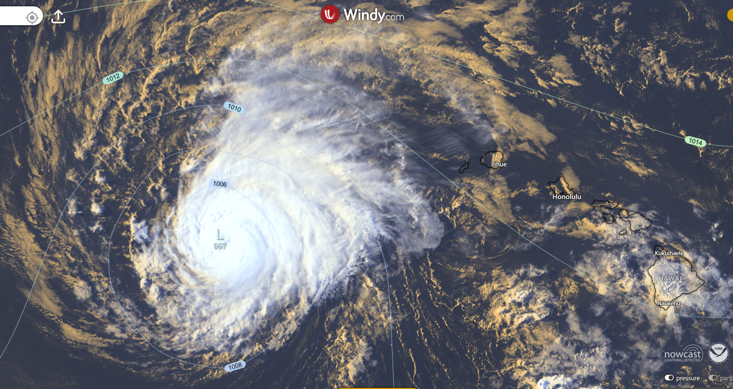
How do tropical depressions form? These systems develop when a disorganised cluster of thunderstorms, known as a tropical disturbance, organises around a defined low pressure system. Fueled by sea surface temperatures above 26.5 degrees Celsius and low vertical wind shear, the convective activity begins rotating to form a closed circulation.
Key takeaways
Tropical depressions require sea surface temperatures of at least 26.5 degrees Celsius to generate sufficient latent heat of condensation.
The Coriolis effect must be present to initiate cyclonic rotation, meaning these systems rarely form within five degrees of the equator.
Low vertical wind shear is essential to keep the developing storm core vertically aligned so it can deepen and intensify.
In the Australian region, the Bureau of Meteorology typically monitors these early-stage systems under the classification of a "tropical low".
A system is upgraded from a depression to a named tropical storm or cyclone once sustained winds reach the World Meteorological Organization threshold of 63 km/h.
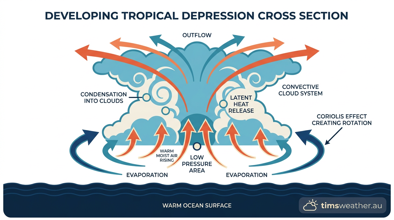
Diagram explaining how do tropical depressions form with warm sea surface temperatures and the Coriolis effect.
The foundational ingredients for cyclogenesis
To understand exactly how do tropical depressions form, meteorologists look for a specific alignment of oceanic and atmospheric conditions. A tropical depression is the lowest recognised tropical cyclone stage. It acts as the initial closed-circulation phase of a developing storm. Without the right balance of heat, moisture and rotation, isolated thunderstorms will struggle to merge into a cohesive weather system.
Why do tropical depressions need warm water to form?
The primary energy source for any developing tropical system is oceanic heat. The minimum sea surface temperature for tropical depression formation is universally recognised as 26.5 degrees Celsius, extending to a depth of at least 50 metres. As documented in NOAA educational materials, hurricanes and their precursor depressions form over very warm ocean waters near the equator, driven by warm and moist air rising from the sea surface. This warm water provides enormous amounts of water vapour to the lower troposphere.
When this moisture rises and cools, it condenses into clouds. This phase change from vapour to liquid releases the latent heat of condensation into the surrounding atmosphere. The added heat warms the air column, causing it to expand and diverge aloft. This process lowers the surface barometric pressure, which then draws in more moist air from the surrounding marine environment to feed a self-sustaining thermodynamic engine.
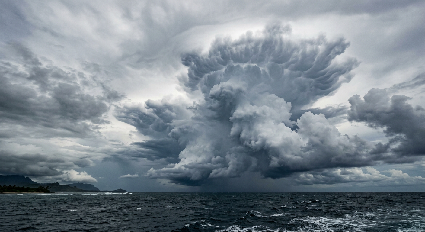
A disorganised cluster of thunderstorms over the ocean during the early stages of a developing tropical low.
Can a tropical depression form without the Coriolis effect?
Heat and moisture alone are not enough to create a rotating storm. The earth's rotation provides the necessary spin through the Coriolis effect. As air moves toward the developing low pressure system to replace the rising air, the Coriolis effect deflects this wind. In the southern hemisphere, the air is deflected to the left, creating a clockwise spin. In the northern hemisphere, it deflects to the right for a counter-clockwise rotation.
Because the Coriolis force is negligible at the equator, tropical depressions almost never form between five degrees north and five degrees south latitude. In these equatorial zones, the air simply flows straight into the low pressure centre and fills it, preventing a closed circulation from organising and building the necessary vorticity.
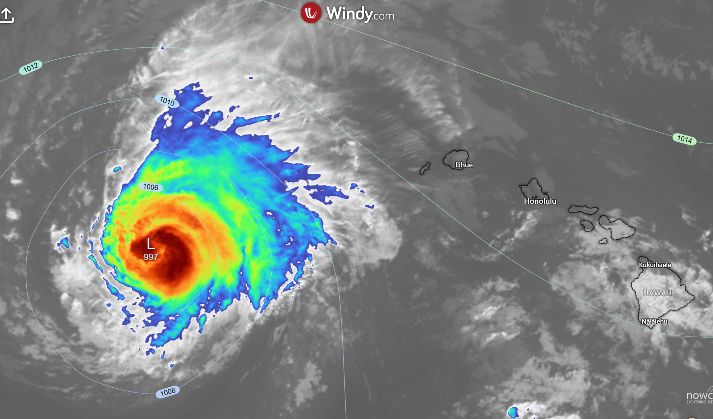
Tropical depression Lala after impacting the Hawaiian Islands 18/08/2026 - Infrared satellite imagery - courtesy of www.windy.com.
Atmospheric instability and the CISK mechanism
Atmospheric instability allows air parcels to continue rising once they are forced upward. Meteorologists often describe the growth of a depression using a concept called Conditional Instability of the Second Kind (CISK). In simple terms, CISK is a positive feedback loop between individual thunderstorms and the larger-scale low pressure area.
Individual thunderstorms release heat that lowers the central pressure of the broad system. The lowered pressure increases the inward flow of trade winds at the surface. This convergence forces more air upward, generating more thunderstorms. If environmental conditions remain favourable, this feedback loop forces the scattered convective activity to merge into a single and highly organised entity.
Moisture availability in the mid-troposphere
For a depression to take shape, there must be abundant moisture availability in the mid-levels of the troposphere (around three to five kilometres above the surface). If the surrounding air is too dry, any dry air entrained into the thunderstorms will cause the cloud droplets to evaporate. This evaporation cools the air, creating heavy downdrafts that choke off the rising air currents. When investigating how do thunderstorms form within these clusters, forecasters pay close attention to humidity profiles to ensure the mid-levels are moist enough to support continuous convection.
How do tropical depressions form: the step-by-step process
The evolution from clear skies to a spinning depression does not happen instantly. It follows a sequenced timeline that depends heavily on the surrounding synoptic environment. Operational centres routinely assign formation probabilities over a period of 48 hours to seven days when monitoring potential development zones.
Stage 1: The initial tropical disturbance
Every tropical depression begins as a tropical disturbance. This initial stage is characterised by a loose cluster of thunderstorms with minimal wind strength, serving as the raw material for growth as outlined in early storm stage documentation. In the Atlantic basin, these often originate from African easterly waves. In the Pacific and Australian basins, they frequently spark along old frontal boundaries or the active monsoon trough.
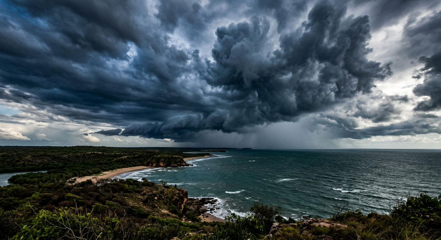
Heavy monsoon clouds over northern Australian waters where tropical depressions frequently form.
Stage 2: What causes a tropical low to strengthen?
For a disturbance to strengthen, the cluster of thunderstorms must remain over water that provides high heat energy. The step-by-step progression relies heavily on this oceanic fuel, an energy transfer process explained in hurricane formation step-by-step records. As the thunderstorms persist over several days, they begin to lower the air pressure at the surface.
During this intermediate phase, forecasters watch for signs of sustained convection. How how do cumulonimbus clouds form is important here, as continuous strong updrafts are required to keep the system's central pressure falling. The system starts showing curved cloud banding, but it lacks a completely closed ring of surface winds.
At what wind speed does a disturbance become a tropical depression?
The transition to a formal depression occurs the moment the system develops a closed low-level circulation. This means the surface winds form a complete, uninterrupted circle around a defined centre. At this stage, the maximum sustained winds are less than 63 kilometres per hour. Even if a system fails to intensify further into a named storm, it can still persist for days as a depression. For example, Tropical Depression Eight-E persisted in the eastern Pacific without being upgraded, as detailed in National Hurricane Center updates during August 2026.
Upper-Level Outflow: The Exhaust Pipe of Cyclogenesis
As the depression draws massive amounts of air inward at the surface and forces it upward, that air must have a place to go once it reaches the top of the troposphere. This creates upper-level outflow. You can think of outflow as the exhaust pipe of the storm engine. High-altitude winds spread outward from the centre, carrying away the spent air. If this outflow is restricted, the air piles up, the central pressure rises, and the depression suffocates. A healthy, expanding canopy of cirrus clouds on satellite imagery is a clear sign that a developing depression has established strong outflow.
Regional variations: Coral Sea, Arafura Sea and Indian Ocean
While the physics remain identical globally, the triggers and regional terminology differ across the southern hemisphere. The Australian region features unique geography and oceanography that heavily influence how these early systems behave.
How do tropical depressions form in Australia?
Across northern Australia, the mechanics of cyclogenesis are deeply tied to seasonal shifts in wind patterns. The Bureau of Meteorology monitors vast stretches of ocean where these systems can take shape. The process often begins when the hot continent draws moist marine air inland, creating dynamic zones of convergence over the surrounding waters.
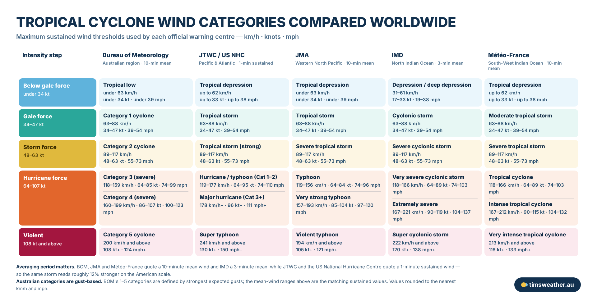
Official tropical cyclone wind thresholds used by the Bureau of Meteorology, JTWC and the US National Hurricane Centre, JMA, IMD and Meteo-France, shown in km/h, knots and mph.
This is why one storm can carry two different labels on the same day. A system with 60 km/h sustained winds is a “tropical low” in a Bureau of Meteorology bulletin, a “tropical depression” in a JTWC advisory, and a “depression” to the India Meteorological Department. Nothing about the storm has changed — only the naming convention of the agency issuing the warning.
The second catch is how long the wind is measured for. The Bureau, JMA and Meteo-France average the wind over 10 minutes, IMD over three minutes, and JTWC and the US National Hurricane Centre over just one minute. A shorter averaging window catches stronger peaks, so the same storm reads roughly 12 per cent stronger on the American scale. Australian categories 1 to 5 add one more wrinkle: they are defined by the strongest expected gusts rather than the mean wind, which is why a Category 2 cyclone here can sound fiercer than a tropical storm elsewhere even when the sustained winds match.
The Role of the ITCZ in Australian Tropical Development
Cyclogenesis here is frequently linked to the Intertropical Convergence Zone (ITCZ) and the Monsoon Trough. The Monsoon Trough is a broad area of low pressure where the northwest monsoon winds meet the southeast trade winds. This collision forces immense amounts of moist air upward, creating near-continuous thunderstorm activity during the wet season.
When studying how mesoscale convective systems form along this trough, forecasters look for embedded areas of low pressure. If an embedded low drifts out over warm water and separates slightly from the main trough axis, it can rapidly organise into an independent depression.
Where do tropical depressions form in the Coral Sea versus the Indian Ocean?
The location of formation often dictates the speed of development. When tracking tropical cyclone formation Coral Sea forecasters observe systems that sometimes take several days to slowly wrap up and organise. The Coral Sea provides a vast, deep pool of warm water, allowing systems to track westward toward the Queensland coast while gradually building strength over a week.
In contrast, development in the eastern Indian Ocean off the coast of Western Australia can be much more volatile. The presence of extremely warm ocean currents and favourable atmospheric steering patterns can cause tropical lows to form rapidly and track parallel to the Pilbara coast, often intensifying very quickly into severe cyclones.
Regional Variations: The Arafura and Timor Sea Dynamics
The Arafura Sea and the Gulf of Carpentaria feature relatively shallow waters that heat up extremely fast during the Australian summer. A tropical low drifting from the Northern Territory over the Gulf of Carpentaria can rapidly tap into this intense heat. The shallow, super-heated water provides explosive moisture, sometimes allowing a depression to spin up into a severe tropical cyclone in less than 24 hours.
Influence of the Madden-Julian Oscillation
The Madden-Julian Oscillation (MJO) is a major driver of Australian tropical weather pulses. The MJO is an eastward-moving wave of cloud and rainfall that travels around the globe near the equator every 30 to 60 days. When the active phase of the MJO enters the Indian Ocean and moves across Australian longitudes, it drastically enhances broad-scale atmospheric rising air. This active phase provides the extra lift needed to turn an ordinary cluster of thunderstorms into an organised tropical low.
Distinguishing Between a Tropical Low and a Tropical Depression
Meteorological agencies worldwide use slightly different naming conventions for the same physical weather phenomena. Knowing these regional differences helps in interpreting global weather outlooks, especially when answering the broader question of how do tropical cyclones form in different ocean basins.
What is the difference between a tropical low and a depression?
In Australia, the Bureau of Meteorology does not operationally use the term "tropical depression" in its public warnings. Instead, Australian Tropical Cyclone Warning Centres refer to these developing systems as a "tropical low". A tropical low is the direct equivalent of an international tropical depression. The Bureau will track and issue bulletins for a significant tropical low if it poses a heavy rainfall or strong wind threat to coastal communities, even before it reaches cyclone strength.
Tropical depression wind speeds Australia versus international scales
The World Meteorological Organization (WMO) classification framework establishes clear intensity thresholds. A system is classified as a depression or low while its maximum sustained winds remain below 62 km/h (33 knots). Once sustained winds cross this threshold, global agencies upgrade the system based on WMO standards, as recorded in Hurricane Research Division classifications.
At this point, the Joint Typhoon Warning Center, the Japan Meteorological Agency, or the Bureau of Meteorology will apply the regional upgrade: classifying it as a tropical storm, typhoon, or Category 1 tropical cyclone, and assigning it an official name.
Development Stage | Typical Wind Speed | Key Characteristics |
|---|---|---|
Tropical Disturbance | Less than 40 km/h | Loose cluster of thunderstorms, no closed surface circulation. |
Tropical Depression / Low | 40 to 62 km/h | Closed low-level circulation, persistent central convection. |
Tropical Storm / Cat 1 Cyclone | 63 to 118 km/h | Named system, clear cyclonic shape, gale-force winds. |
Severe Tropical Cyclone | Above 118 km/h | Well-defined eye, hurricane-force destructive winds. |
Monitoring the signs of a developing tropical low
Forecasters monitor specific atmospheric variables to predict whether a disturbance will dissipate or successfully complete the cyclogenesis process.
Why 26.5 Degrees Celsius is the Critical Threshold
Thermodynamic principles dictate that sea surface temperatures below 26.5 degrees Celsius generally do not produce enough evaporation to sustain a tropical system. Below this threshold, the air parcel rising from the ocean surface simply cannot carry enough latent heat to overcome the natural cooling of the atmosphere. Without sufficient heat transfer, the rising air column simply collapses before it can establish a deep, persistent area of low pressure. This explains why systems rapidly lose their organisation if they drift over cooler waters or move inland.
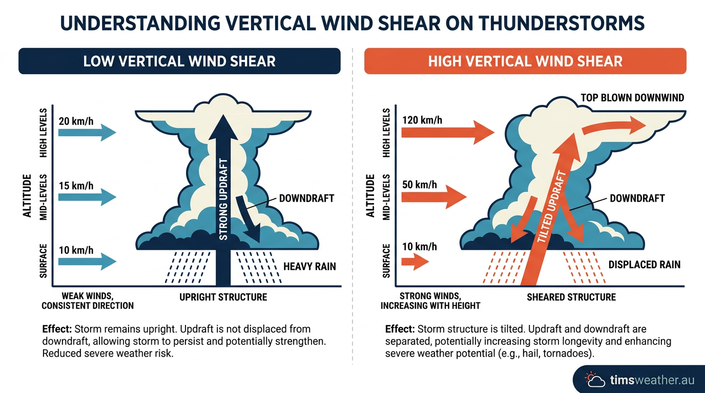
Diagram showing how low vertical wind shear allows a tropical depression to stay vertically aligned and strengthen.
The role of low vertical wind shear
Vertical wind shear measures the change in wind speed and direction at different altitudes. For a system to remain viable, this shear must stay exceptionally low. A technical breakdown of how low vertical wind shear allows the storm core to remain vertically aligned reveals that an upright column of rising air is vastly more efficient at dropping surface pressure. When strong upper-level winds are present, they effectively tilt or blow the thunderstorm tops away from the surface centre. By keeping the storm core stacked, latent heat remains concentrated directly over the circulation centre, allowing the depression to deepen.
Pre-cyclogenesis monitoring and formation risk
During pre-cyclogenesis monitoring, meteorologists assess these environmental conditions to forecast potential development. As noted by NOAA meteorological tracking mechanisms, agencies evaluate wind shear, moisture, and sea temperatures to anticipate cyclone formation. In the Atlantic and eastern Pacific basins, forecasters routinely assign a 20 to 60 percent formation risk over a 48-hour to seven-day period in their tropical weather outlooks. These probabilities reflect the statistical likelihood that a cluster of thunderstorms will successfully transition into a depression within the given timeframe, based on real-time atmospheric data.
Frequently asked questions
A tropical depression is a low-pressure system with a closed wind circulation and sustained surface winds below 62 kilometres per hour. It represents an early stage of tropical cyclone development, occurring when a cluster of thunderstorms organises around a definite centre, fuelled by heat from warm ocean waters.
Source: aoml.noaa.gov
Further reading and resources
Explore trusted articles, books, videos and other resources to go deeper on this topic.
weather.govReference
Tropical Definitions
Background reference on How Do Tropical Depressions Form? The Complete Meteorological Guide from weather.gov.
emergency.fsu.eduReference
Tropical Storms & Hurricanes: The Basics
Background reference on How Do Tropical Depressions Form? The Complete Meteorological Guide from emergency.fsu.edu.
scied.ucar.eduReference
How Hurricanes Form - UCAR Center for Science Education
Background reference on How Do Tropical Depressions Form? The Complete Meteorological Guide from scied.ucar.edu.
en.wikipedia.orgReference
Tropical cyclone
Background reference on How Do Tropical Depressions Form? The Complete Meteorological Guide from en.wikipedia.org.
dickinsontexas.govReference
Science of Storms | Dickinson, TX - Official Website
Background reference on How Do Tropical Depressions Form? The Complete Meteorological Guide from dickinsontexas.gov.
oceanservice.noaa.govReference
How do hurricanes form? - NOAA's National Ocean Service
Background reference on How Do Tropical Depressions Form? The Complete Meteorological Guide from oceanservice.noaa.gov.
ametsoc.orgArticle
Tropical Cyclone Forecasting in the United States
In-depth coverage on How Do Tropical Depressions Form? The Complete Meteorological Guide from ametsoc.org.
saalck.pressbooks.pubArticle
Lab #11: Hurricanes – Introduction to Meteorology
In-depth coverage on How Do Tropical Depressions Form? The Complete Meteorological Guide from saalck.pressbooks.pub.
noaa.govReference
Hurricanes | National Oceanic and Atmospheric ...
Background reference on How Do Tropical Depressions Form? The Complete Meteorological Guide from noaa.gov.
youtube.comVideo
Tropical System Forming...
Video coverage on How Do Tropical Depressions Form? The Complete Meteorological Guide from youtube.com.
Planning weeks ahead?
Check Australia's long-range seasonal outlook for rainfall, temperature and the climate drivers (ENSO, IOD, SAM, MJO) shaping the next three months.
View Australia's Seasonal Weather Forecast