
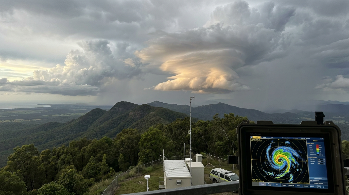
Mesoscale convective vortices formation occurs when latent heat release within the stratiform precipitation region of a mesoscale convective system creates a mid-level warm core. This diabatic heating lowers pressure, drawing in air that begins to rotate due to the Coriolis force, resulting in a self-sustaining mid-level circulation.
Key takeaways
- A mesoscale convective vortex (MCV) is a rotating mid-level circulation left behind by a decaying complex of thunderstorms.
- These vortices typically measure between 100 and 300 kilometres across and can persist for days after the parent storm dissipates.
- Formation relies on the release of latent heat in a weak wind shear environment, allowing the warm core to remain vertically stacked.
- Over warm oceans, an MCV can serve as the initial seed for cyclogenesis, occasionally transitioning into a tropical cyclone.
- They are a major trigger for extreme rainfall events globally, including flash flooding in complex terrain and coastal regions.
What is a mesoscale convective vortex?
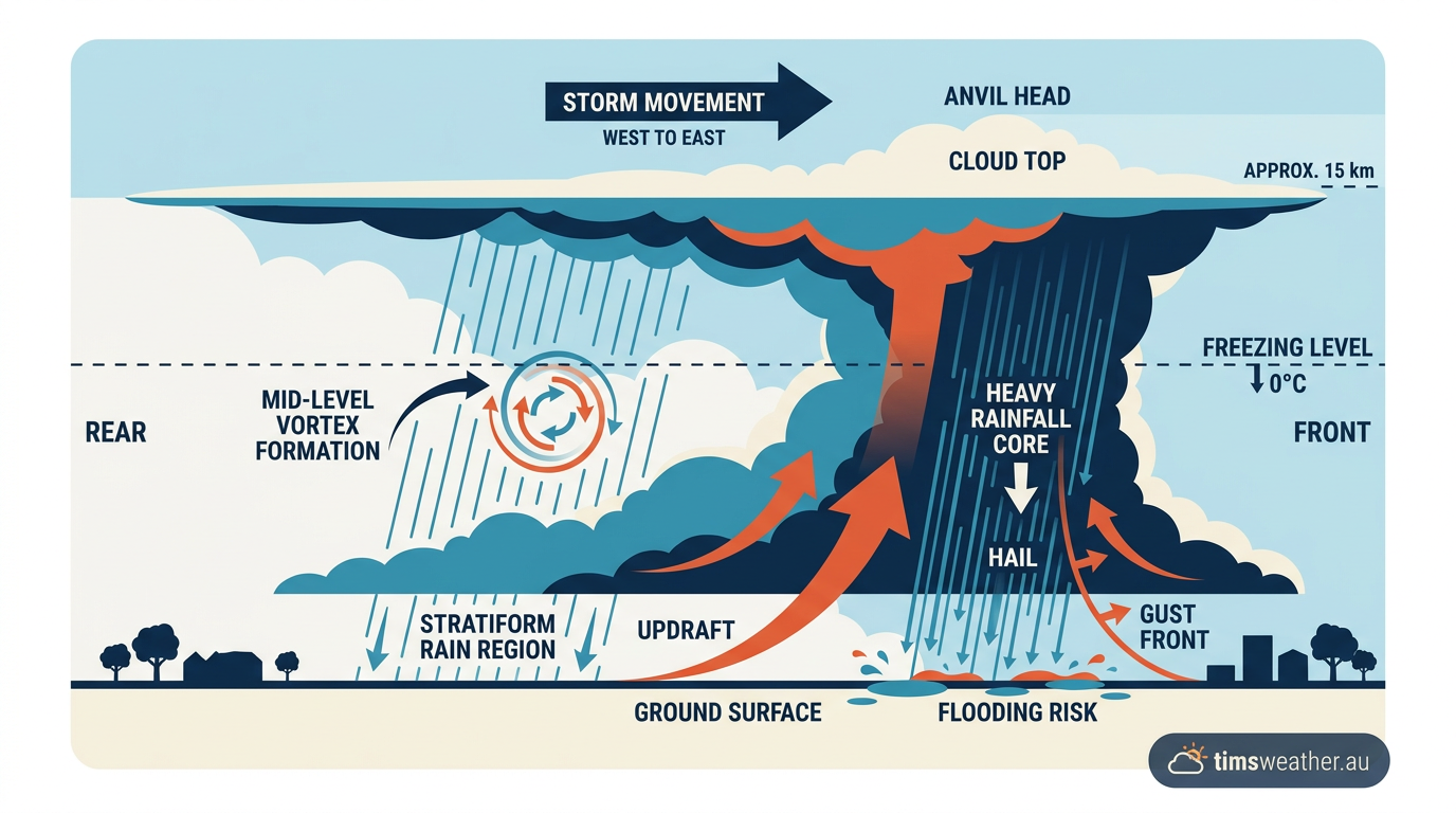
Meteorologists categorise weather systems by their physical size to better understand the atmosphere. "Mesoscale" weather features range from roughly 10 to 1000 km in horizontal extent, distinct from both microscopic cloud physics and massive continental fronts. Within this category, an MCV is a specific type of mid-level cyclonic spin that develops inside a larger mesoscale convective system (MCS). Operational research tracking horizontal dimensions notes that these vortices typically measure 100 to 300 km across, sometimes spanning further depending on the parent storm complex size.
Unlike a surface low pressure system, a mesovortex is primarily a mid-tropospheric feature. While its vertical extent can range from the surface up to the tropopause in some highly developed cases, the strongest circulation is almost always centred aloft, typically between 3 and 5 kilometres above the ground. You can think of it as a remnant storm signature. Long after the intense lightning and severe downdrafts of a thunderstorm cluster fade, a slowly spinning wheel of cloud and moisture continues to drift through the middle atmosphere.
The role of the mesoscale convective complex
The most intense subset of an MCS is known as a Mesoscale Convective Complex (MCC). These are massive, long-lived, circular clusters of thunderstorms that often form overnight. Research meteorologists specialising in mesoscale dynamics, alongside peer-reviewed studies in the Journal of the Atmospheric Sciences, show that these features act as atmospheric memory. They generate a pocket of potential vorticity that retains the energy of the deceased thunderstorms. If this spinning moisture packet encounters a new zone of atmospheric instability the following day, it can act as the focal point for new convection.
When assessing the high and low pressure systems Australia relies on to drive its weather patterns, the synoptic chart tells only part of the story. Embedded within those broad air masses are these mesoscale features that dictate exactly where the heaviest rain will fall. Because they sit in the middle atmosphere, high-level cirrus clouds often obscure them until the surrounding weather clears.
The mechanics of mesoscale convective vortices formation
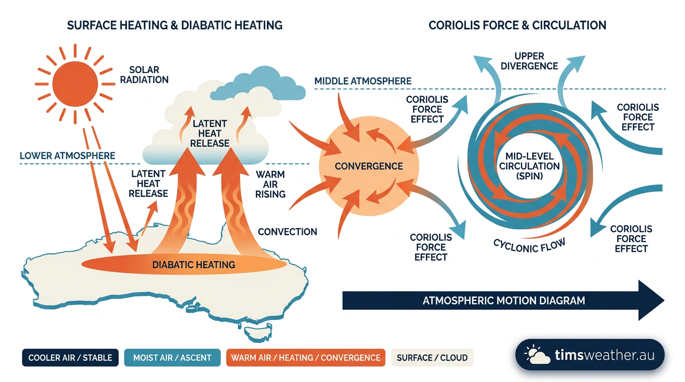
The science behind this process is anchored in the classic 1989 work by Menard and Fritsch, which demonstrated that an MCS generates a mid-level mesoscale vortex during its mature and dissipating stages. The process requires specific thermodynamic ingredients and atmospheric conditions to align perfectly.
Stratiform precipitation area and diabatic heating
The mid-level vortex development process begins when individual thunderstorms merge into a single, massive complex. As heavy rain and primary updrafts push forward along the leading edge, a broad area of lighter, steady rain develops at the rear of the storm. This is known as the stratiform precipitation area.
Within this stratiform zone, water vapour constantly condenses into raindrops, releasing large amounts of latent heat of condensation into the middle atmosphere. This process is called diabatic heating. As the mid-levels warm, the air density decreases and pressure drops. To fill this low-pressure void, surrounding air is drawn inwards. As this air converges, the Earth's rotation (the Coriolis force) causes it to spin. In the Southern Hemisphere, this spin is clockwise, while in the Northern Hemisphere, it is counter-clockwise.
The Rossby radius of deformation
For this newly formed vortex to survive, the atmosphere must achieve quasi-geostrophic balance. This balance depends on a mathematical principle known as the Rossby radius of deformation, which determines whether a weather system will simply radiate its energy away as gravity waves or trap it as rotational energy.
Taking a technical deep cover the Rossby radius of deformation specifically for Southern Hemisphere latitudes reveals why storm size matters. Because the Coriolis parameter changes significantly from the equator down to Tasmania, a convective system must be sufficiently wide to exceed this radius locally. If the precipitation shield covers a wide enough area relative to its latitude, the heating creates a balanced, stable vortex. The energy is successfully converted into a mid-level circulation that can persist independently of the original updrafts.
Vertical wind shear and stability
The final necessary ingredient is the background wind environment. The atmosphere must feature weak vertical wind shear. Vertical wind shear refers to the change in wind speed and direction with height. If the upper-level winds are too strong relative to the low-level winds, they will blow the top off the developing vortex.
Strong shear tears the circulation apart before it can consolidate. Conversely, in a low-shear environment, the mid-level circulation maintains its vertically stacked structure, allowing the pressure gradients to tighten and the spin to become self-sustaining. This is why observers typically spot MCVs during the warmer months when upper-level jet streams are weaker and positioned further toward the poles.
Identifying MCVs on BOM radar and global satellite data
Detecting a remnant MCV requires careful observation and advanced meteorological tools. Meteorologists often examine Skew-T log-p diagrams to look for the saturated mid-levels and the warm core signature that indicate a developing vortex. The temperature lines in the mid-troposphere will often skew slightly warmer than the surrounding environment, confirming the diabatic heating process is actively working.
Satellite imagery and water vapour loops
On high-resolution satellite platforms, analysing specific case studies using NOAA GOES-16 infrared and water vapor loops shows that an MCV often looks like a miniature, cloud-filled spiral spinning over land. Once the deep convective clouds of the parent storm melt away, the mid-level vortex becomes visible as a pinwheel of middle and high clouds.
The water vapour channels are highly effective for tracking this, showing a distinct swirl of moisture outlined in operational summaries persisting for up to 12 hours after the parent MCS dissipates. In ideal conditions, MCVs often last several hours to multiple days, acting as a spark to regenerate the remnant MCV and new convection each afternoon when surface temperatures peak.
Doppler radar and rear-inflow jets
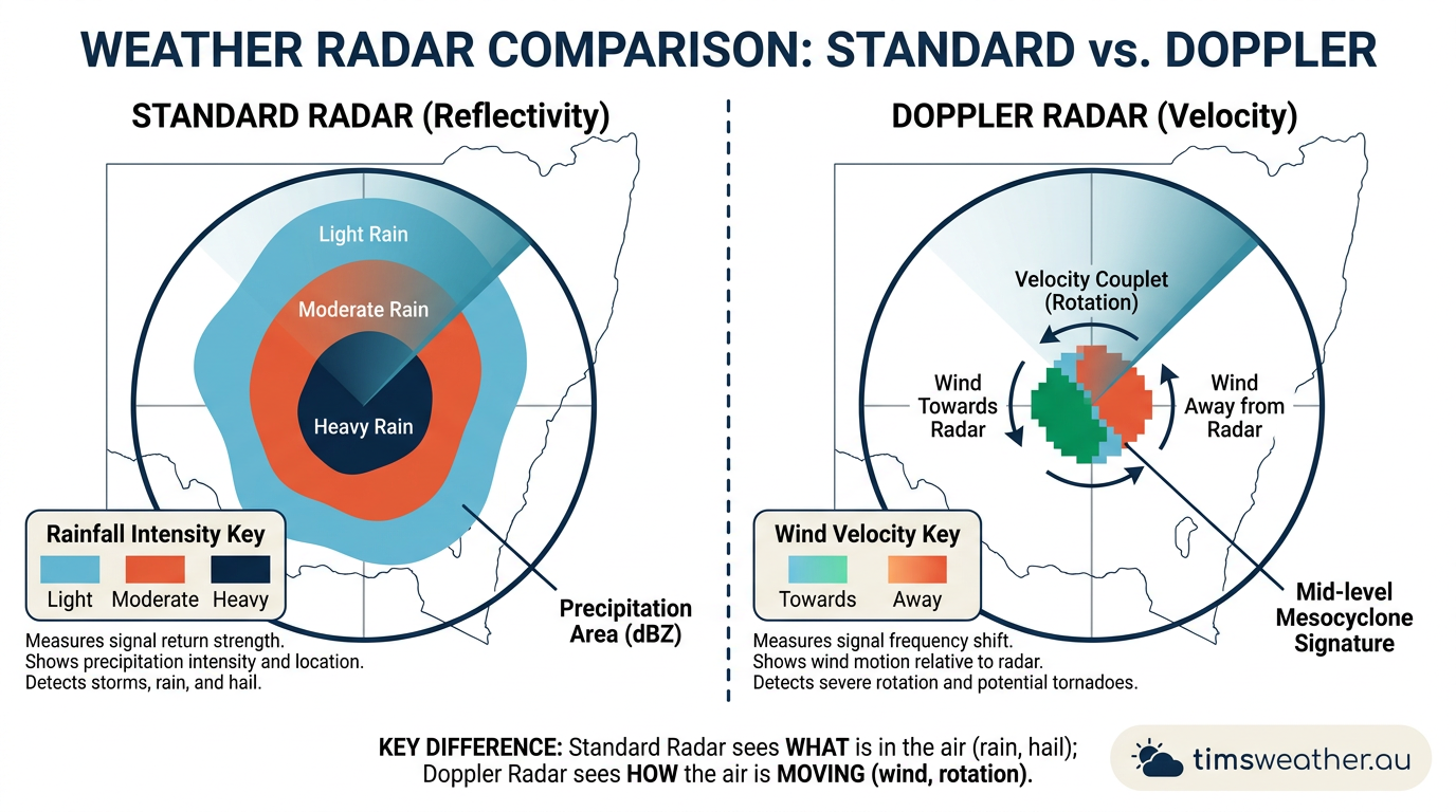
Identifying MCVs in Bureau of Meteorology (BOM) Doppler data involves looking at velocity signatures rather than just rainfall reflectivity. The Doppler radar will show a broad, weak couplet of inbound and outbound winds in the middle atmosphere.
Often, the development of the vortex is preceded by a rear-inflow jet. This is a channel of strong, dry winds descending at the back of the storm that initially drives squall line formation forward. As the system matures, the Coriolis force deflects this jet, causing it to wrap around the northern edge of the storm in the Southern Hemisphere and assist in closing off the mid-level circulation.
Distinguishing between MCVs and tropical transition events
One of the most complex aspects of forecasting mesovortices is predicting what happens when they move from land out over open, warm ocean waters. Distinguishing between MCVs and tropical transition events is a major focus for global agencies like the Joint Typhoon Warning Center and the Bureau of Meteorology, as the mechanics driving these convective systems shift entirely over water.
Transitioning over the Coral Sea and Gulf of Carpentaria
The historical IBTrACS record contains numerous instances where a land-based thunderstorm cluster drifted offshore and underwent cyclogenesis. If you are learning how do tropical cyclones form, understanding the seed disturbance is the first step. In Australia, the transition of land-based MCVs into tropical cyclones frequently occurs when a decaying monsoon low or an MCV moves off the Western Australian coast, off the Top End into the Gulf of Carpentaria, or off the Queensland coast into the Coral Sea.
The monsoon trough in Northern Australia often provides the background rotation necessary for initial MCV development. Once over the water, the warm ocean surface provides a massive influx of latent heat, replacing the energy the vortex lost when its parent thunderstorms died. If vertical wind shear remains low, new deep convection will erupt around the old mid-level circulation. The spin works its way down to the surface, and a tropical low is born.
| Feature | Mesoscale Convective Vortex | Tropical Cyclone |
|---|---|---|
| Primary Energy Source | Latent heat from decaying parent thunderstorms | Continuous latent heat flux from warm ocean water |
| Circulation Core | Mid-troposphere (strongest 3 to 5 km aloft) | Surface-based (strongest winds near the ocean surface) |
| Formation Environment | Often forms over land within a stratiform rain shield | Requires warm ocean water (typically above 26.5 °C) |
| Longevity | Hours to a few days | Days to weeks |
Predicting long-lived mesovortices in the Coral Sea requires tracking broader climate drivers. When the active phase of the Madden-Julian Oscillation (MJO) aligns with the Intertropical Convergence Zone (ITCZ), the background environment becomes highly favourable for an MCV to tighten its surface pressure gradients and evolve into a Category 1 cyclone. Examining tropical cyclone formation Coral Sea dynamics reveals just how frequently these mid-level remnants act as the catalyst for named storms.
How MCVs influence weather in Australia and globally
Even if an MCV never transitions into a tropical cyclone, its mere presence in the atmosphere can trigger extreme weather. MCVs are frequently associated with significant rainfall, focusing ascent to sustain precipitation well beyond the life of the initial storm.
Global impacts and the Tehran floods
A notable global example of this destructive potential occurred during the July 2022 flash flood in Northern Tehran. A detailed vorticity budget analysis of the event highlighted the vortex's role in driving extreme rainfall over complex terrain. The slow-moving nature of the MCV, combined with the orographic lift of the nearby mountains, forced continuous moisture convergence over the exact same area, resulting in catastrophic flooding within a few short hours.
Australian severe weather and East Coast Lows
In the Australian context, these mid-level circulations are infamous for generating "rain bombs" or extreme, localised rainfall events. Historical Australian weather events, such as the devastating 2022 floods across the eastern seaboard, demonstrated where mesoscale circulations played a critical role in localising extreme totals. During periods of South East Queensland severe weather, intense convection frequently merges into larger complexes.
When supercell thunderstorms in Australia group together overnight, the remnant spin left behind often drifts slowly south into Northern New South Wales. If this mid-level spin interacts with a moist onshore airflow from the Tasman Sea, it can anchor intense rain bands over the coast for days. The role of MCVs in Australian East Coast Low development is also significant. In highly baroclinic environments, a mid-level mesovortex drifting out of the interior can interact with a coastal trough, rapidly intensifying the surface pressure gradients to form a severe East Coast Low characterised by gale-force winds and flooding rain.
Frequently asked questions
These vortices typically form within the stratiform rain region of a mature or decaying mesoscale convective system. As rain-cooled air descends and latent heat is released aloft, a mid-level area of low pressure develops. This process, aided by the Earth's rotation, spins up a compact, self-sustaining circulation that can persist for several days.
Source: pmc.ncbi.nlm.nih.gov
Further reading and resources
Explore trusted articles, books, videos and other resources to go deeper on this topic.
youtube.comVideo
Morse Code of Weather: How a Mesoscale Convective Vortex ...
Video coverage on How Do Mesoscale Convective Vortices Form? A Meteorological Guide from youtube.com.
mdpi.comArticle
Vorticity Budget and Formation Mechanisms of a ...
In-depth coverage on How Do Mesoscale Convective Vortices Form? A Meteorological Guide from mdpi.com.
skybrary.aeroArticle
Mesoscale Convective System (MCS)
In-depth coverage on How Do Mesoscale Convective Vortices Form? A Meteorological Guide from skybrary.aero.
schumacher.atmos.colostate.eduReference
Research: Mesoscale convective vortices (MCVs) and their ...
Background reference on How Do Mesoscale Convective Vortices Form? A Meteorological Guide from schumacher.atmos.colostate.edu.
forecast.weather.govReference
Glossary - NOAA's National Weather Service
Background reference on How Do Mesoscale Convective Vortices Form? A Meteorological Guide from forecast.weather.gov.
en.wikipedia.orgReference
Mesoscale convective system
Background reference on How Do Mesoscale Convective Vortices Form? A Meteorological Guide from en.wikipedia.org.
foxweather.comArticle
What is a mesoscale convective system? - FOX Weather
In-depth coverage on How Do Mesoscale Convective Vortices Form? A Meteorological Guide from foxweather.com.
oceanroute.comArticle
The Mesoscale Convective Systems
In-depth coverage on How Do Mesoscale Convective Vortices Form? A Meteorological Guide from oceanroute.com.
journals.ametsoc.orgArticle
Mesoscale Convective Vortex that Causes Tornado-Like ...
In-depth coverage on How Do Mesoscale Convective Vortices Form? A Meteorological Guide from journals.ametsoc.org.
Planning weeks ahead?
Check Australia's long-range seasonal outlook for rainfall, temperature and the climate drivers (ENSO, IOD, SAM, MJO) shaping the next three months.
View Australia's Seasonal Weather Forecast