
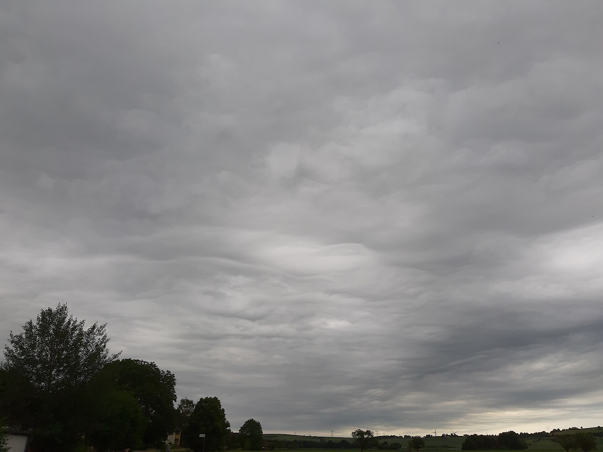
Asperitas clouds are a rare and striking cloud feature with a rough, wave-like underside that can look like a stormy sea when seen from below. The World Meteorological Organization recognised asperitas as a supplementary cloud feature in 2017. They are usually seen with layered cloud types such as altocumulus and stratocumulus, and their appearance points to wave activity and wind shear high in the atmosphere.
Key takeaways
- Asperitas is a supplementary cloud feature, not a separate cloud genus.
- The Cloud Appreciation Society's collection of images was key to gaining official recognition for this sky pattern.
- These wavy cloud formations are not dangerous by themselves; any weather risk comes from the nearby system.
- Asperitas can look dramatic, but the feature itself does not mean severe weather is certain.
- Cloud watchers most often report asperitas on altocumulus or stratocumulus cloud decks.
Asperitas clouds: formation and characteristics
Asperitas clouds are a rare cloud feature with a rough, corrugated base. The name comes from the Latin for roughness, which suits the appearance well. Rather than forming as a cloud genus of its own, asperitas describes a shape seen on the underside of existing cloud layers.
That shape is usually associated with wave motion in the atmosphere. Wind shear, which is a change in wind speed or direction with height, can disturb a cloud layer and create rolling, uneven patterns. Gravity waves can also help shape the cloud base into the choppy, undulating look often linked with asperitas.
In simple terms, the cloud layer acts like a thin sheet being pushed and pulled by air moving at different speeds. The result can be a sky that looks like dark water viewed from underneath. This is why asperitas is often described in plain language as a wave-like cloud feature or a rough cloud formation.

The global history of a new cloud classification
Before asperitas was officially named, observers often photographed it but had no standard term to use. The Cloud Appreciation Society collected many of these images and helped build support for formal recognition. That effort led to the World Meteorological Organization adding asperitas to the International Cloud Atlas in 2017.
That classification matters because it gives meteorologists and cloud watchers a consistent label for a distinctive appearance. It also helps separate asperitas from other rare cloud types that can look similar at first glance. In Australian weather reporting, the WMO cloud atlas remains the reference point for cloud names and features.
Asperitas is placed under the WMO cloud classification system as a supplementary feature. It is not a main cloud genus, and it does not replace the cloud type it is attached to. In practice, that means you may see asperitas on the underside of altocumulus or stratocumulus clouds rather than as a standalone cloud layer.
For cloud watchers, that detail is useful. The key question is not just whether the sky looks rough, but what cloud layer is carrying that texture. That is the difference between a named feature and a cloud genus.

How atmospheric conditions create wavy features
Asperitas forms when the air above and below a cloud layer moves in different ways. The atmosphere behaves like a fluid, so waves can pass through it in much the same way ripples move across water. When those waves reach a cloud deck, they can deform the cloud base into a series of dips, folds and lumps.
Wind shear is one of the main ingredients. It can stretch and distort a layer of cloud, especially when the air is stable enough for a clear boundary to hold its shape. Gravity waves can also play a role, including waves triggered by fronts, thunderstorms, or airflow crossing terrain.
How do asperitas clouds form?
They form when a cloud layer sits in air that is being disturbed by wave motion and wind shear. The result is a rough, uneven underside that can appear to move like water, even though the cloud itself is drifting with the broader air flow.
In Australia, this can happen after a front passes, near areas of uplift, or along the edge of a large cloud band. The exact setup varies, but the common thread is a cloud layer with enough structure to show the wave pattern clearly.
It is better to think of asperitas as a visual sign of atmospheric motion rather than as a weather type on its own. The cloud feature may appear before, during or after unsettled conditions, depending on the local setting and the larger weather system nearby.

Distinguishing asperitas clouds from other wave-like formations
Many people first notice asperitas by mistake. It can sit in the same family of sky patterns as other wave-like clouds, but the texture is what sets it apart. The underside is usually more chaotic and less orderly than the neat rolls seen in classic undulatus clouds.
Asperitas clouds vs undulatus asperitas
Undulatus is a description used for cloud layers that have a repeated wave pattern. Asperitas is different because the base looks rough, uneven and strongly corrugated. The two terms are sometimes seen together in discussion, but asperitas is the feature name recognised by the WMO, while undulatus describes the wave pattern in the cloud layer.
When people say wave-like clouds, they may be referring to more than one cloud feature. Asperitas usually looks darker, more broken and more agitated than smooth undulating bands. That is why it often attracts attention from photographers and weather watchers.
To help with identification, it is useful to compare asperitas with other visually dramatic formations, such as mammatus clouds and lenticular clouds.
| Feature Type | Visual Appearance | Formation Process | Common Cloud Base |
|---|---|---|---|
| Asperitas | Rough, wave-like underside with deep folds | Wind shear and atmospheric waves | Altocumulus, stratocumulus |
| Undulatus | Regular rolling bands or ripples | Wave motion in a cloud layer | Altocumulus, altostratus, stratocumulus |
| Mammatus | Hanging pouch-like lobes | Sinking air and cloud evaporation | Cumulonimbus |
| Lenticular | Smooth lens or stack shape | Standing waves over terrain | Altocumulus lenticularis |
Rare cloud types and common look-alikes
Rare cloud types often get grouped together because they can all appear unusual at a glance. Asperitas is best identified by its rough underside and broad, wave-like structure. Lenticular clouds are smoother and shaped more like a lens, while mammatus clouds hang beneath a storm cloud in a series of pouches.
If the cloud deck has regular, parallel ripples, it may be undulatus rather than asperitas. If the underside looks chaotic, uneven and deeply textured, asperitas is more likely. Good timing and a clear view from below make the difference easier to see.

Asperitas clouds in Australia: sightings and potential locations
Asperitas clouds in Australia can appear wherever the atmosphere produces the right wave pattern and cloud layer. They are not tied to one fixed place, but they are more likely to be noticed when fronts, showers or uplift create strong changes in the air above the ground.
Cloud watchers in inland and coastal areas alike may spot them. Elevated locations, open horizons and areas where weather systems often pass through can all improve the chance of seeing the feature. In Australia, that may include places near the Great Dividing Range, as well as cities and coastal strips during changeable weather.
Are asperitas clouds rare?
Yes. Asperitas is considered uncommon because the atmosphere has to line up in a fairly specific way for the feature to appear clearly. The cloud layer needs enough moisture, stability and wave motion for the rough underside to stand out.
That said, the clouds they form on, such as altocumulus and stratocumulus, are common enough. It is the exact combination of motion and structure that makes asperitas stand out as a rare cloud feature.
Can asperitas clouds predict weather?
Not on their own. Asperitas can appear in unsettled conditions, but the feature itself is not a reliable forecast tool for severe weather. It is best treated as a sign that the atmosphere is active and that wave motion is affecting the cloud layer.
Weather context matters. If asperitas appears ahead of a front, near showers or alongside other signs of instability, that broader pattern may be more important than the cloud feature itself.
Are asperitas clouds dangerous?
No. Asperitas clouds are not dangerous by themselves. They can look dramatic, but the feature is mainly an indicator of atmospheric motion. Any weather risk comes from the system nearby, not from asperitas as a cloud feature.
Can asperitas clouds cause bad weather?
No. They do not cause bad weather. They may appear with fronts, thunderstorms or other unsettled systems, but they do not create those conditions. Think of asperitas as a visual clue, not a cause.
Capturing asperitas clouds: photography tips for stunning shots
Because asperitas clouds have strong texture, they often photograph well when the light is low and the cloud base is angled across the frame. Early morning and late afternoon can help bring out contrast. Side lighting can also make the folds and shadows easier to see.
A wide-angle lens works well if the cloud deck covers a large part of the sky. If the feature sits low on the horizon, include foreground detail such as trees, buildings or open land to give the cloud scale. That can make the rough underside feel more dramatic in the final image.
For the clearest shot, keep the horizon level and avoid heavy overexposure. The dark ridges in asperitas can lose detail if the image is too bright. If the clouds are moving quickly, take a series of frames so you can choose the sharpest version later.
Photographers should also pay attention to safety. If asperitas appears with thunderstorm activity or a strong change in weather, stay aware of your surroundings and avoid exposed areas. The best cloud photo is never worth taking a risk.
Asperitas clouds FAQ
What does asperitas mean?
Asperitas comes from Latin and refers to roughness. The name fits the cloud feature because the underside looks coarse, uneven and heavily textured.
Is asperitas a cloud genus?
No. Asperitas is a supplementary cloud feature in the World Meteorological Organization system. It describes the shape of a cloud base, not a separate cloud genus.
What clouds are most often linked with asperitas?
Asperitas is most often linked with altocumulus and stratocumulus cloud layers. Those clouds provide the broad base that can be shaped into a rough, wave-like form.
Why do people call them tsunami clouds?
Some people use the term tsunami clouds because the underside can resemble rough water or a wave front. It is an informal nickname, not an official cloud name.
Where can I learn more about cloud names?
The World Meteorological Organization's International Cloud Atlas is the main reference for cloud classification. The Cloud Appreciation Society also has material and images that can help with recognition.
Related guides
Sources
- A New Edition of the International Cloud Atlas (wmo.int)
- International Cloud Atlas translated into official UN languages (wmo.int)
- Classifying clouds (wmo.int)
- International Cloud Atlas (cloudatlas.wmo.int)
- International Cloud Atlas translated into official UN languages (wmo.int)
- Victory for Cloud Appreciation Society as asperitas formally classified (abc.net.au)
Last verified: 2026-06-30
Frequently asked questions
No, the clouds themselves are not dangerous, but they often appear near unstable weather and thunderstorms. This means they can be a visual sign of rougher air and changing weather nearby, rather than a hazard on their own, so just be aware.
Source: earthsky.org
Further reading and resources
Explore trusted articles, books, videos and other resources to go deeper on this topic.
weather.metoffice.gov.ukReference
Asperitas clouds - Met Office
Explores the mystery and debate surrounding the formation of asperitas clouds from the UK's national weather service.
apod.nasa.govReference
APOD: 2025 August 17 – Asperitas Clouds Over New Zealand - NASA
Provides an astronomical perspective on asperitas clouds, highlighting their stunning appearance and unusual occurrence with an image of asperitas over New Zealand.
www.theguardian.comArticle
Stunning 'new' cloud formations captured in updated atlas – in pictures
A visual gallery showcasing asperitas and other newly recognized cloud formations, offering real-world examples and context.
weather.comArticle
Weather Words: Asperitas Clouds | Weather.com
An explainer from Weather.com that delves into the characteristics and formation of asperitas clouds.
eos.orgArticle
Science Explains “Rough and Chaotic” Cloud Feature - Eos.org
A scientific article discussing the mechanisms behind the 'rough and chaotic' appearance of asperitas clouds, including research insights.
www.goodreads.comBook
James Gurney's Blog, page 33 - Goodreads
Provides an artist's perspective on asperitas clouds, describing their appearance as 'upside-down ocean waves' ideal for visual representation.
www.youtube.comVideo
Earth's Rarest Cloud Type Finally Caught on Camera | Asperitas ...
A video explaining why asperitas clouds are considered rare and how they form, offering a visual and auditory learning experience.
Asperitas Clouds - YouTube
A short video showcasing the distinctive features of Asperitas clouds. Ideal for quick visual understanding.
Surreal undulatus asperatus cloud formations time-lapse above ...
Earth's Rarest Cloud Type Finally Caught on Camera | Asperitas Clouds ... In 2007, Elon Musk Predicted Everything (Rare Lost Interview) ... Go to channel History ...
Unusual cloud formations - Met Office
Climate explained · What is climate change? Causes of climate change · Effects ... Asperitas clouds. Read · LEARN ABOUT. Contrails or condensation trails. Read.
Planning weeks ahead?
Check Australia's long-range seasonal outlook for rainfall, temperature and the climate drivers (ENSO, IOD, SAM, MJO) shaping the next three months.
View Australia's Seasonal Weather Forecast