
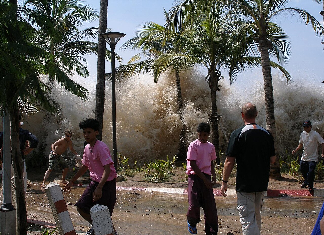
Tsunamis form by the rapid displacement of a massive water column, typically triggered by megathrust earthquakes at subduction zones. When tectonic plates shift abruptly, they vertically displace the ocean floor, sending shockwaves of kinetic energy through the water that propagate outward as high-speed, long-wavelength waves.
Key takeaways
Tsunamis are generated by the sudden vertical displacement of the ocean floor, most frequently caused by massive subduction zone earthquakes.
Unlike wind-driven surface waves, tsunami energy travels through the entire depth of the water column, allowing it to retain energy over vast distances.
In deep oceanic basins, these waves can travel at hundreds of kilometres per hour while maintaining a very low surface amplitude.
As the waves reach shallow coastal bathymetry, the shoaling effect slows their phase speed and drastically increases their destructive wave height.
Global early warning systems rely on a combination of seismic threshold data and deep-ocean pressure sensors to detect anomalous waves before they strike coastal communities.
How do tsunamis form: The physics of ocean displacement
The scientific process of how do tsunamis form begins with an enormous, sudden transfer of kinetic energy into the ocean environment. Whenever a large volume of seawater is displaced from its natural equilibrium state by a profound geological event, the force of gravity immediately acts to restore that equilibrium. This rapid restoration process generates a series of oscillating waves that radiate outward from the original source of the disturbance in all directions.
The initial trigger is almost entirely geological rather than atmospheric in nature. While meteorologists study how do tropical cyclones form through the gradual accumulation of latent heat and atmospheric moisture over weeks, seismologists track tsunamis by measuring immediate, violent mechanical energy transfers from the Earth's crust directly into the overlying sea.
The mechanics of vertical displacement
For a catastrophic tsunami to develop, the precipitating geological event must physically move a truly massive amount of water. This requirement is why the dominant cause of tsunamigenesis is a powerful undersea earthquake that shifts the seabed on a vertical axis. When a section of the ocean floor suddenly thrusts upward or drops downward over thousands of square kilometres, it lifts or drops the entire column of water situated above it.
This sudden vertical push translates the immense potential energy of the displaced water column into kinetic energy. Based on historical disaster data from international humanitarian groups, the resulting tsunami waves can easily exceed heights of 30 metres upon landfall and reach open-ocean transit speeds approaching 800 km/h.
Tsunami propagation: Not just large wind-driven waves
Wind-driven surface waves and tsunami waves operate under fundamentally different principles of fluid dynamics. A standard wind wave affects only the uppermost layers of the ocean, typically featuring a wavelength measuring less than 100 metres from crest to crest. In stark contrast, a tsunami involves the displacement of the entire water column from the deep seafloor all the way to the ocean surface.
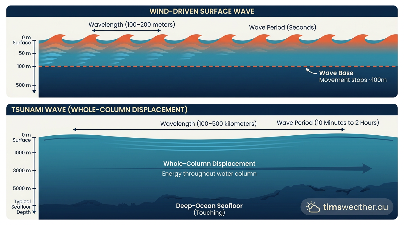
Because the kinetic energy extends completely to the ocean floor, a tsunami always behaves mathematically as a shallow-water wave, even in the deepest trenches of the ocean. The phase speed of a shallow-water wave is determined entirely by the depth of the water and the acceleration due to gravity. In deep oceanic basins, this physical relationship allows tsunami waves to travel at extraordinary speeds.
In waters that are 4,000 metres deep, tsunami waves can sustain velocities of up to 200 metres per second, closely matching the cruising speed of a commercial jet aircraft. Also, because their wavelengths can stretch up to 200 kilometres between crests, the waves lose very little energy to internal friction as they traverse the globe. This highly efficient energy retention explains why a single geological rupture can severely affect coastlines located many thousands of kilometres away.
Subduction zones: Why megathrust earthquakes create the largest tsunamis
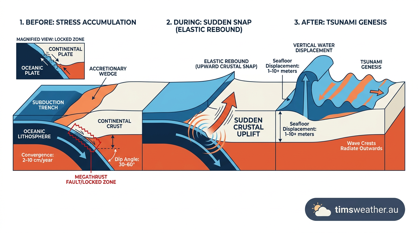
Subduction zones are highly capable of generating tsunamis because they regularly produce megathrust earthquakes that force massive sections of the sea floor upward or downward. A subduction zone occurs where tectonic plate movement forces one dense oceanic plate to slide directly beneath another, lighter continental plate.
Over centuries of microscopic movement, intense friction causes these two converging plates to lock together tightly. As the lower oceanic plate continues to push downward into the mantle, it drags the leading edge of the upper continental plate with it, building immense elastic strain within the Earth's crust.
When the frictional strength of the locked fault is finally overcome, the upper plate violently snaps back to its original, unstrained position. This sudden elastic rebound acts like a giant paddle beneath the ocean, displacing hundreds of cubic kilometres of seawater in a matter of seconds.
The Pacific Ring of Fire, a massive horseshoe-shaped geological belt of subduction zones encircling the Pacific Ocean basin, is the most active region on Earth for this specific type of seismic activity. The sudden, violent release of energy during these megathrust events is wholly responsible for the most significant and destructive tsunamis in recorded human history.
Fault rupture and dual-wave generation
The sheer size of the fault line rupture dictates the initial wavelength and the total kinetic energy transferred. When the fault snaps, it does not just push the water straight up. Instead, it frequently tilts the entire sea floor, creating a massive uplift on one side and a corresponding subsidence, or drop, on the other.
This complex physical deformation of the seabed creates a paired wave crest and trough at the ocean surface, which then splits into two distinct waves. One wave travels out toward the deep ocean basin, while a secondary, often steeper wave travels back toward the nearest continental coastline. This dual-wave generation pattern is a common hallmark of major megathrust earthquakes.
Historic trans-oceanic tsunamis
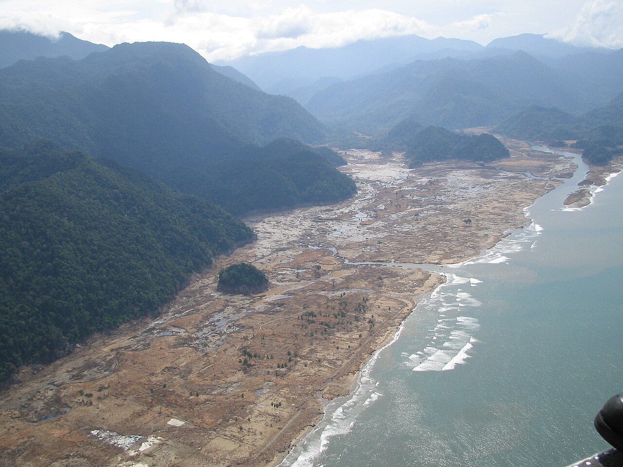
To understand the sheer scale of water displaced by subduction zone events, scientists look to the 26 December 2004 Sumatra-Andaman earthquake. This devastating event, which registered at Mw 9.1 on the moment magnitude scale, caused a 1,500-kilometre section of the fault line to rupture continuously.
It thrust the seafloor upward by several metres and generated a trans-oceanic tsunami that reshaped global warning architectures. Similarly, the historic 22 May 1960 Chile earthquake produced a continuous wave train that successfully crossed the entire Pacific Ocean, heavily impacting regions as far away as Japan.
However, megathrust events do not strictly need to reach a magnitude of 9.0 to displace dangerous amounts of water. Even moderate events in highly active subduction zones pose severe regional risks. For example, a documented Mw 7.4 earthquake near Miyako, Japan, on 20 April 2026 clearly demonstrated that shallow offshore earthquakes well below magnitude 8.0 can still trigger significant vertical ocean displacement if the rupture geometry is highly favourable to seabed uplift.
Strike-slip faults vs megathrust earthquakes
It is necessary to recognise that megathrust earthquakes cause the specific vertical seafloor displacement that pushes water upward, while strike-slip faults move horizontally and generally do not displace enough water to create a widespread tsunami.
In a strike-slip fault system, two tectonic plates slide past one another laterally along a vertical fracture. Because the primary direction of the bedrock movement is horizontal, the sea floor does not lift or drop the heavy water column resting above it. Without that critical vertical push, the massive transfer of kinetic energy into the ocean does not materialise.
This is exactly why a powerful terrestrial or lateral event, such as a severe magnitude 7.5 quake or even a magnitude 7.8 quake that ruptures inland or horizontally along the coast, might shake major cities violently but leave the adjacent ocean relatively calm. Ultimately, it is the physical geometry of the fault plane and the specific direction of the ground rupture, rather than the raw magnitude number alone, that dictates whether tsunami generation will occur.
Trigger Event | Geological Mechanism | Water Displacement Type | Potential Hazard Range |
|---|---|---|---|
Megathrust Earthquake | Vertical tectonic plate slip at subduction zones | Full water column (massive volume) | Trans-oceanic |
Underwater Landslide | Submarine sediment or steep slope collapse | Localized lateral and vertical push | Regional or local coasts |
Volcanic Eruption | Caldera collapse or pyroclastic flow entering the sea | Sudden surface and subsurface displacement | Regional or local coasts |
Meteorite Impact | Extraterrestrial body violently striking the ocean | Radial splash and deep cavity formation | Global or trans-oceanic |
Beyond earthquakes: How volcanic eruptions and landslides trigger localized tsunamis
While megathrust earthquakes command the most public attention, sudden material displacement from underwater landslides, volcanic caldera collapses, and pyroclastic flows can also transfer enough energy into the water to create destructive, highly localized tsunamis. These alternative generation mechanisms are equally capable of shifting vast volumes of seawater, often with very little advance warning for nearby coastal residents.
Submarine landslide dynamics
Underwater landslides frequently occur on the steep continental shelves or along the unstable flanks of oceanic islands. When a massive volume of rock, marine sediment, and mud suddenly gives way and slides downward into the ocean depths, it physically pushes the water ahead of it while simultaneously pulling water down into the void left behind. This rapid, dual-action displacement generates highly energetic waves.
While these localized waves typically dissipate their energy faster than earthquake-generated tsunamis and rarely manage to cross entire ocean basins, they pose a severe and immediate threat to nearby coastlines. According to researchers tracking submarine landslides and regional hazards, the kinetic energy released by a sudden slope failure is intensely concentrated. This means the initial wave amplitude near the source can actually exceed the heights produced by major tectonic earthquakes, generating terrifying run-up heights on immediately adjacent shores.
Volcanic caldera collapse and pyroclastic flows
Volcanic activity introduces its own unique set of tsunami triggers into the oceanic environment. When a marine or island volcano erupts violently, several distinct mechanisms can quickly displace coastal water. A pyroclastic flow, which is a superheated, fast-moving avalanche of volcanic gas and heavy rock, can crash down the flank of a volcano and directly into the sea, physically displacing a massive wall of water outward.
Alternatively, a highly explosive eruption might drain the volcano's subterranean magma chamber so rapidly and completely that the unsupported summit collapses inward, forming a caldera. This sudden, catastrophic structural failure creates a massive void in the ocean.
Surrounding seawater immediately rushes inward to fill the collapsing cavity, violently colliding in the centre before rebounding upward to initiate a radiating tsunami wave train. Monitoring these diverse volcanic triggers is just as necessary for comprehensive coastal planning as understanding how do hurricanes form is for seasonal atmospheric preparedness.
The role of coastal bathymetry in tsunami amplification
As a trans-oceanic tsunami eventually leaves the deep ocean and enters much shallower coastal bathymetry, its immense phase speed decreases rapidly while its wave height dramatically increases. In the open ocean, the passage of a tsunami wave often goes completely unnoticed.
A commercial vessel situated in deep water might experience nothing more than a gentle, gradual rise and fall of half a metre spread over a period of twenty minutes. Because the wavelength is extraordinarily long, the actual slope of the wave is negligible, rendering it virtually invisible to the naked eye.
However, the total kinetic energy carried by the wave remains nearly constant as it travels. This fundamental principle of energy conservation dictates the true danger of the event. As the tsunami approaches a continental shelf and the ocean depth decreases, the physics of wave propagation shifts abruptly.
The friction of the rising sea floor begins to drag on the bottom layers of the wave column, forcing the wave to slow down. Just as meteorologists observe complex fluid dynamics when studying how do waterspouts form over warm ocean currents, geophysicists observe drastic structural transformations as a high-speed wave interacts with a sloping seabed.
The physics of the shoaling effect
The shoaling effect occurs when the leading edge of a tsunami wave slows down in shallow water, forcing the faster-moving water trailing behind it to pile up rapidly and compress into a towering, destructive wall. Because the wave's total energy must be strictly conserved throughout this process, the kinetic energy lost to reduced forward velocity is immediately converted into potential energy. This energy conversion manifests physically as an extreme, rapid increase in wave amplitude.
During the intense shoaling process, the wave's trailing edge is still travelling at deep-water speeds while the front edge is braking violently against the continental slope. This forces the immense, 200-kilometre wavelength to compress tightly into a band just a few kilometres across. Since all that displaced water must go somewhere, it is forced to build vertically.
The resulting phenomenon does not resemble a traditional breaking surf wave at a beach. Instead, it behaves exactly like a rapidly rising tide or a solid, turbulent plateau of moving water that surges relentlessly inland, carrying immense destructive force that can level concrete structures and sweep away heavy debris.
The drawback phenomenon
This incoming, powerful surge is frequently preceded by a dramatic, unnatural drawback of coastal waters. If the trough of the tsunami wave reaches the coastline before the initial crest, it acts like a massive vacuum, rapidly pulling water away from the shore.
This exposes stretches of the sea floor that are normally submerged, sometimes stranding fish and marine life. This drawback is a critical natural warning sign. The exposure of the seabed clearly indicates that the massive wave crest is closely following behind, often arriving within minutes to violently inundate the coast.
Monitoring and early warning systems
To mitigate the catastrophic impacts of ocean displacement, global agencies use a highly integrated combination of seismic magnitude thresholds and deep-ocean pressure sensors to detect tsunamis and issue warnings long before the waves reach vulnerable coastlines.
The National Oceanic and Atmospheric Administration (NOAA), the Pacific Tsunami Warning Center, and the United States Geological Survey (USGS) collaborate continuously to monitor the Pacific Ring of Fire alongside other tectonically active zones. Because a tsunami can rapidly cross an ocean basin, real-time data acquisition and analysis are essential for public safety.
Seismic thresholds and epicenter calculations
The first step in the warning process is the rapid, automated evaluation of seismology data. Whenever a significant undersea earthquake is detected, global sensor networks instantly calculate its moment magnitude, depth, and exact epicentre coordinates. For submarine earthquakes, threat evaluation protocols commonly trigger alerts when an event registers at a baseline threshold of M7.0 or higher, as empirical data indicates this is the minimum rupture size likely to shift the necessary volume of water to create a local tsunami threat.
Validating the threat with DART buoy networks
Once a seismic threat is identified through the initial earthquake data, the focus immediately shifts to verifying whether actual water column displacement has occurred. This critical verification is achieved through the Deep-ocean Assessment and Reporting of Tsunamis (DART) buoy system.
These highly sensitive bottom-pressure recorders sit directly on the deep ocean floor, thousands of metres below the surface, and measure the microscopic changes in water pressure caused by a passing tsunami wave. Because regular wind-driven waves do not affect the deep-water column, the DART sensors isolate the unique pressure signature of a tsunami.
When anomalous pressure readings are confirmed, the seabed sensor transmits acoustic signals upward to a moored surface buoy, which then relays the data via satellite to regional warning centres. This definitive confirmation allows scientists to move from theoretical threat evaluation to concrete wave height forecasting models before the wave makes landfall, significantly reducing the occurrence of false alarms.
Global coordination and the role of the ITIC
Because trans-oceanic tsunamis do not respect national borders or oceanic boundaries, mitigating their impact requires intense international cooperation. The International Tsunami Information Center works alongside global agencies to coordinate basin-wide warning services and standardise emergency response protocols.
Following the catastrophic 2004 Indian Ocean Tsunami, these global authorities spearheaded the deployment of new sensor networks and seismic stations across previously unmonitored regions. Just as meteorologists track atmospheric pressure changes to understand how does El Niño form across the Pacific, oceanographers now have a continuous, real-time stream of deep-ocean pressure data to track tsunami propagation globally.
Local versus distant tsunami threats
The timeline for these early warnings depends heavily on the physical proximity of the tectonic plate movement to the affected coastline. For a distant tsunami generated on the opposite side of the Pacific Ring of Fire, forecasters often have several hours to analyse bathymetry data and issue precise evacuation orders. Conversely, a local tsunami generated by a subduction zone earthquake just a few kilometres offshore might strike the nearest coast in under fifteen minutes.
In these rapid-onset scenarios, the intense, prolonged shaking of the earth itself serves as the primary natural warning. According to news reports on tsunami mechanics, immediate evacuation to higher ground is required even before official sirens can sound.
In many historical events, coastal residents who waited for an official warning rather than reacting to the seismic activity found themselves caught in the devastating surge, highlighting the constant need for public education regarding natural warning signs.
Last verified: 2026-09-17
Frequently asked questions
Tsunamis occur when a large undersea earthquake causes the seafloor to shift vertically, either up or down. This sudden movement displaces a massive volume of water, creating waves that radiate outward across the ocean. These waves can travel vast distances, eventually impacting distant coastlines with significant energy.
Source: sciencecouncil.noaa.gov
Further reading and resources
Explore trusted articles, books, videos and other resources to go deeper on this topic.
usgs.govReference
Life of a Tsunami | U.S. Geological Survey - USGS
Background reference on How Do Tsunamis Form? The Geological Physics Explained from usgs.gov.
preventionweb.netArticle
An ocean scientist explains the physics of tsunamis | PreventionWeb
In-depth coverage on How Do Tsunamis Form? The Geological Physics Explained from preventionweb.net.
youtube.comVideo
The CRUEL Physics behind Tsunamis! - YouTube
Video coverage on How Do Tsunamis Form? The Geological Physics Explained from youtube.com.
rctwg.humboldt.eduReference
About Tsunamis
Background reference on How Do Tsunamis Form? The Geological Physics Explained from rctwg.humboldt.edu.
pbslearningmedia.orgArticle
The Birth of a Tsunami | PBS LearningMedia
In-depth coverage on How Do Tsunamis Form? The Geological Physics Explained from pbslearningmedia.org.
tsunami.orgArticle
What Causes a Tsunami?
In-depth coverage on How Do Tsunamis Form? The Geological Physics Explained from tsunami.org.
noaa.govReference
The science behind tsunamis - NOAA
Background reference on How Do Tsunamis Form? The Geological Physics Explained from noaa.gov.
legacy.itic.ioc-unesco.orgArticle
How Do Earthquakes Generate Tsunamis?
In-depth coverage on How Do Tsunamis Form? The Geological Physics Explained from legacy.itic.ioc-unesco.org.
rainviewer.comArticle
What Is a Tsunami? How It Is Formed? | RainViewer Blog
In-depth coverage on How Do Tsunamis Form? The Geological Physics Explained from rainviewer.com.
jkgeography.comArticle
Causes of tsunami - GEOGRAPHY MYP/GCSE/DP
In-depth coverage on How Do Tsunamis Form? The Geological Physics Explained from jkgeography.com.
Planning weeks ahead?
Check Australia's long-range seasonal outlook for rainfall, temperature and the climate drivers (ENSO, IOD, SAM, MJO) shaping the next three months.
View Australia's Seasonal Weather Forecast