
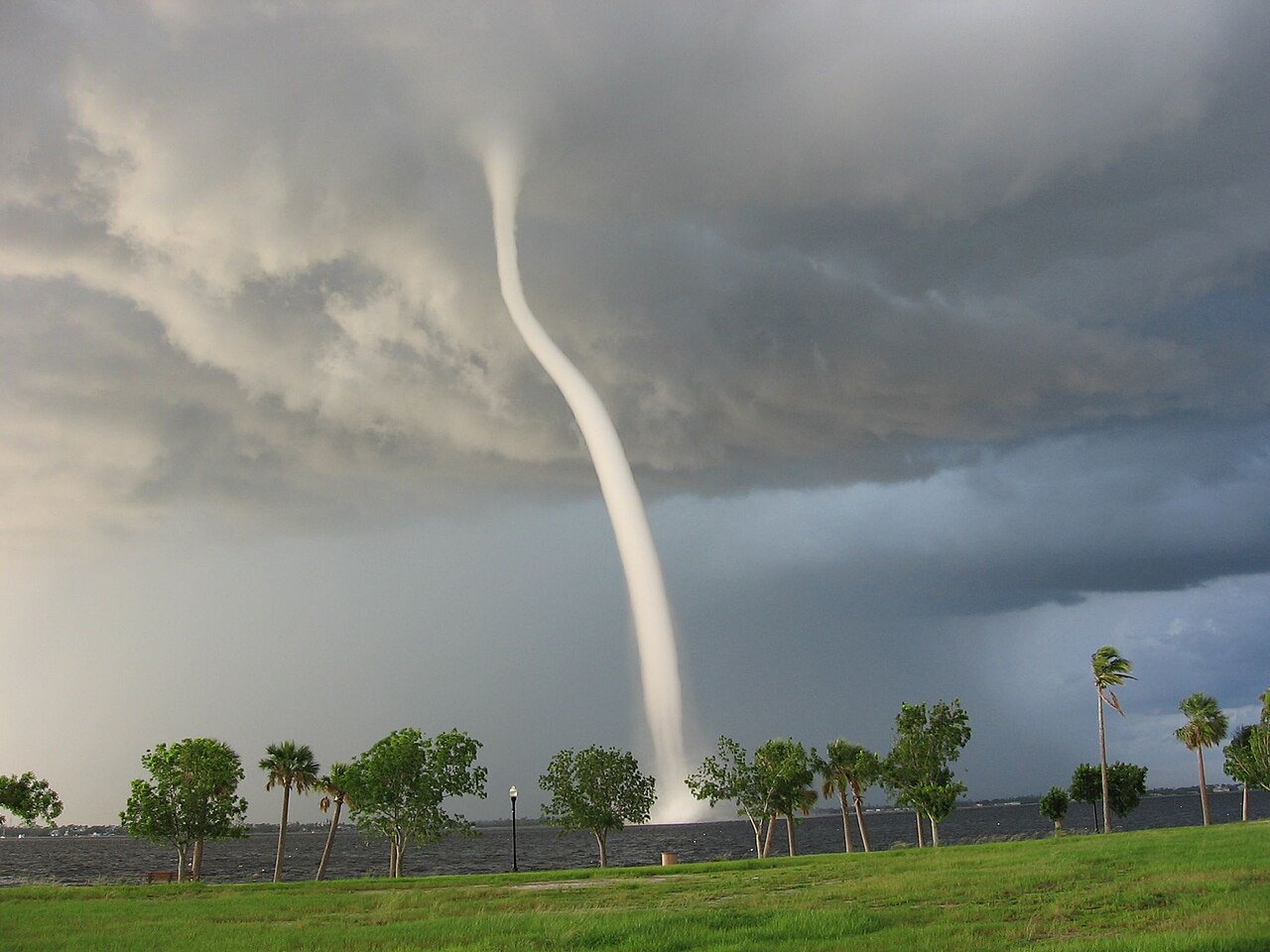
How do waterspouts form depends on their type. Fair-weather waterspouts develop from the water surface up toward cumulus congestus clouds during light wind conditions, while tornadic waterspouts form downward from severe thunderstorms and mesocyclones. Both require high humidity, significant instability in the lower atmosphere, and a source of localized cyclonic rotation.
Key takeaways
Meteorologists divide waterspouts into two main categories: fair-weather waterspouts and tornadic waterspouts.
Fair-weather varieties build upward from the sea surface during light winds and warm water temperatures.
Tornadic waterspouts develop from severe supercell thunderstorms and behave exactly like tornadoes over water.
Despite their gentle name, fair-weather waterspouts can flip small boats and generate hazardous marine conditions.
The East Australian Current and warm coastal waters make the autumn and winter months a peak time for waterspout activity in Australia.
How do waterspouts form: the atmospheric physics
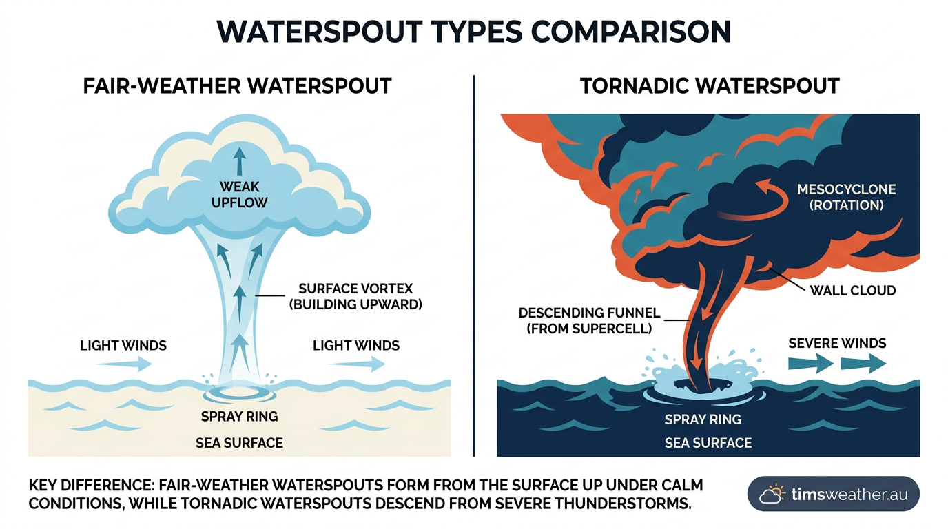
Diagram explaining how do waterspouts form, comparing fair-weather and tornadic types.
To understand the mechanics of these marine weather events, meteorologists rely on strict technical definitions. These definitions separate waterspouts based on their parent clouds and the atmospheric dynamics driving them. While they all look like twisting funnels over the ocean, the way they initiate is vastly different. As highlighted in EarthSky reporting on coastal waterspout events, rotation can either originate at the water surface or descend violently from the cloud base.
Globally, records maintained by the International Centre for Waterspout Research (ICWR) and the European Severe Storms Laboratory (ESSL) show that these events cluster in specific regions. They frequently appear in subtropical marine environments, near large bays, and over warm boundary currents. To make sense of the marine risk, weather services categorise them strictly by their formation mechanism and parent storm structure.
How do waterspouts form in Australian waters?
The vast majority of waterspouts form along the New South Wales and Queensland coastlines when cool air moves over the warm East Australian Current. This sharp temperature contrast creates intense boundary layer instability. As warm, moist air rises rapidly from the ocean surface, localised wind shear causes the rising updraft to spin. Unlike massive tropical cyclones that rely on the Coriolis effect to dictate their rotation direction, fair-weather waterspouts are too small to be influenced by planetary rotation. Their spin direction is determined entirely by the local wind shear at the exact moment the boundary layer air begins to rise.
During the cooler months, the offshore water remains significantly warmer than the surrounding air. This constant transfer of heat and moisture acts as fuel. Once the boundary layer becomes completely saturated, even a gentle land breeze converging with the prevailing ocean breeze can provide enough mechanical lift to trigger rotation and stretch the vortex upward to connect with convective clouds.
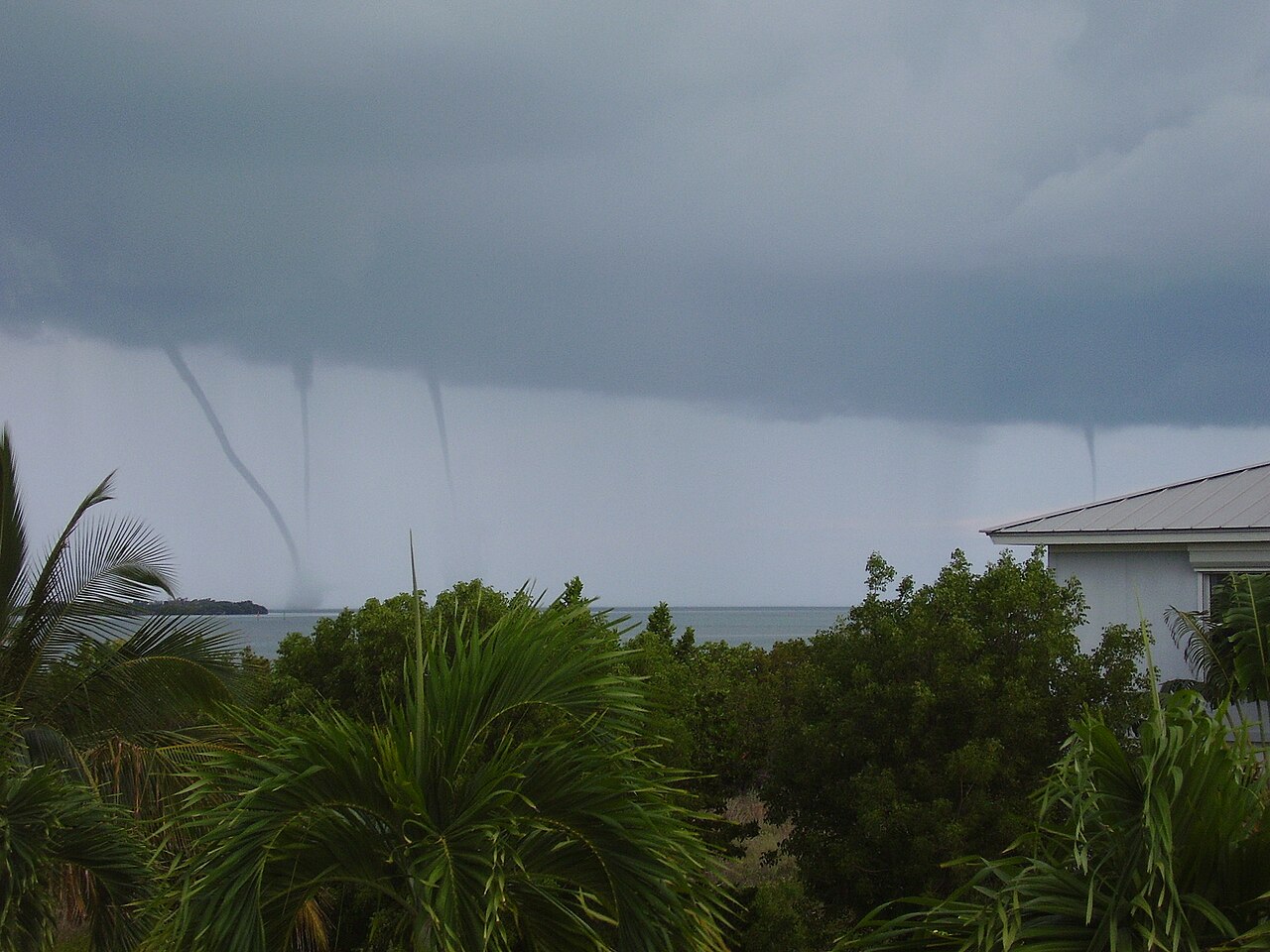
Four waterspouts seen in the Florida Keys, 5 June 2009 - By Thepainguy - Own work, CC BY 3.0, https://commons.wikimedia.org/w/index.php?curid=6968286
The difference between waterspout and tornado structures
The core difference between a fair-weather waterspout and a land-based tornado lies in the direction of development and the presence of a mesocyclone. Tornadic waterspouts are simply tornadoes that happen to sit over water. They require a severe thunderstorm featuring a deep, rotating updraft known as a mesocyclone. For anyone studying supercell tornado formation, the process over the ocean is identical to the process over the plains. The parent storm acts as a vacuum, dropping a destructive funnel down to the sea surface.
Conversely, fair-weather waterspouts are non-supercellular. They typically form under a growing line of cumulus congestus clouds. Instead of a violent storm pushing a funnel downward, light converging winds at the sea surface begin to spin. The gentle updraft of the developing cloud above stretches this surface rotation vertically. Eventually, the pressure drops low enough inside the spinning column for water vapour to condense, making the funnel visible.
The five stages of a fair-weather waterspout
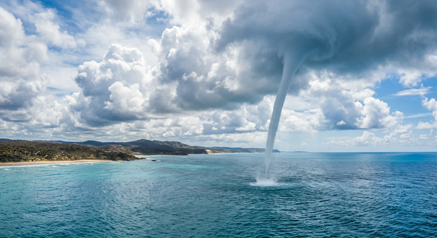
A mature fair-weather waterspout stretching from the ocean up to a cumulus cloud in Australian coastal waters.
Through decades of aerial observation, meteorological pioneer Dr. Joseph Golden defined the five distinct stages of the waterspout life cycle. These stages outline exactly what causes a fair-weather waterspout to mature and eventually dissipate. A popular YouTube educational short frequently referenced by weather students demonstrates these exact phases visually.
Stage 1: The dark spot
The life cycle begins completely out of the sky and directly on the water surface. A prominent dark spot appears on the ocean, signalling a patch of localised wind convergence. This dark spot occurs because the swirling surface winds rough up the water, changing how sunlight reflects off the sea. In clear, warm Australian coastal waters, this stage can be highly visible from elevated coastal vantage points.
Stage 2: The spiral pattern
As the localised rotation strengthens, the dark spot expands into a distinct spiral pattern on the water. Light bands and dark bands of disturbed water spiral inward toward a central point. At this stage, the rising air above the spiral is connecting with the updraft of the parent cloud, but no visible condensation funnel exists yet.
Stage 3: The spray ring
As surface winds accelerate, they begin to whip sea spray upward. A dense ring of swirling water droplets forms around the dark spot. According to the Hong Kong Observatory, this spray ring indicates that the vortex has intensified enough to overcome gravity and lift water directly from the ocean surface. For local mariners, this churning surface water is a clear sign to alter course immediately.
Stage 4: The mature condensation funnel
The waterspout reaches its maximum intensity during the mature stage. As the air pressure inside the rapidly spinning vortex drops, adiabatic cooling forces the ambient water vapour to condense into a visible cloud. This condensation funnel stretches from the cloud base all the way down to the spray ring on the water. It is important to remember that the funnel is mostly made of condensed freshwater vapour from the atmosphere, not heavy saltwater sucked up from the ocean.
Stage 5: Decay and dissipation
Fair-weather waterspouts are fragile systems that rely on a delicate balance of warm inflow and gentle updrafts. They usually decay when the parent cloud matures and begins to rain. The falling precipitation creates a downdraft of cool air. If you want to know how microburst formation works, this exact mechanism of rain-cooled descending air is responsible. The cool downdraft disrupts the warm inflow at the surface, cutting off the waterspout's energy supply. The funnel quickly thins out, contorts, and vanishes.
Environmental drivers: Boundary layers and warm currents
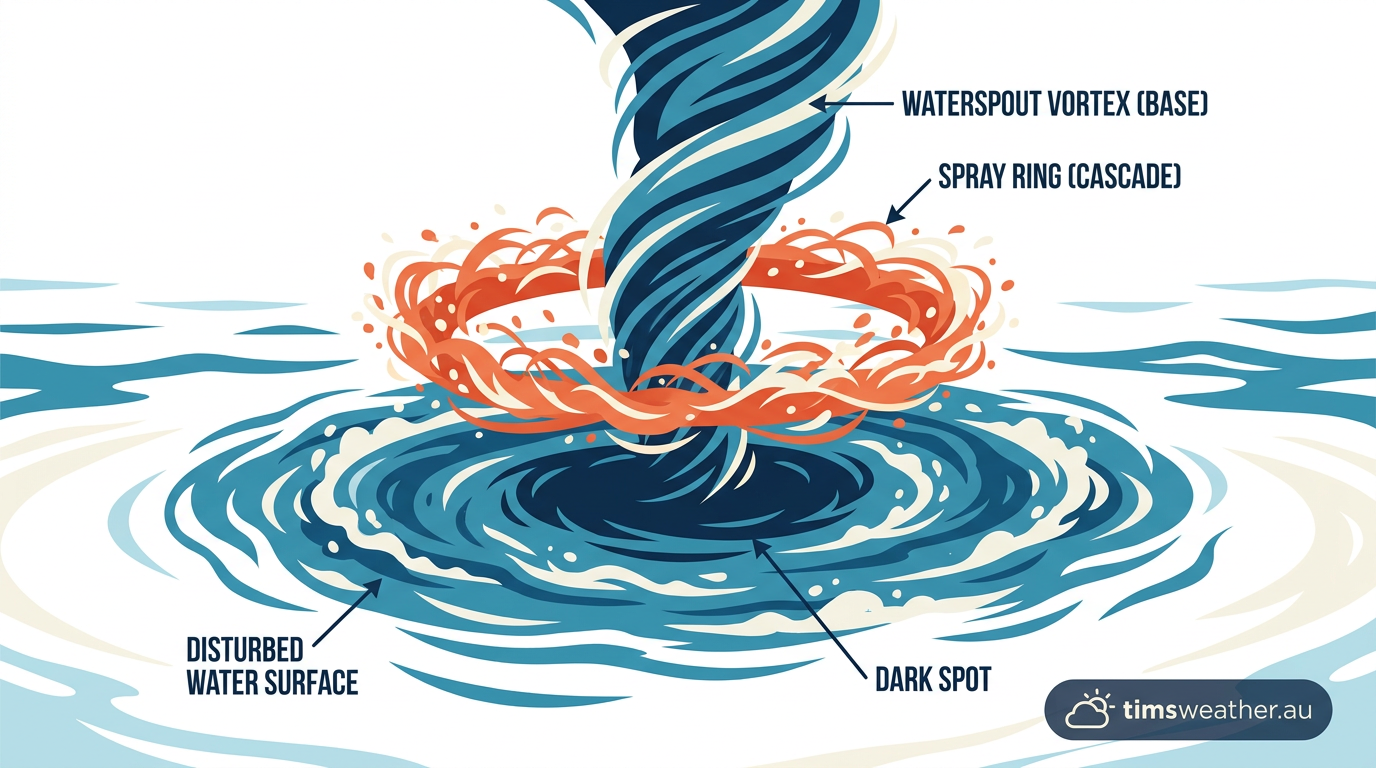
The spray ring and dark spot at the base of a waterspout churning the ocean surface.
Waterspouts do not form randomly. They require a specific thermodynamic setup, usually characterised by high humidity and steep temperature gradients in the lowest kilometre of the atmosphere. When meteorologists look for signs of a developing cumulonimbus cloud that might produce a waterspout, they monitor sea surface temperatures closely.
The impact of the East Australian Current
Along the east coast of Australia, the East Australian Current (EAC) acts as a massive thermal engine. It transports warm water from the Coral Sea southward into the cooler Tasman Sea. During autumn and winter, cold air masses from the Southern Ocean frequently push northward over this warm current.
The vast temperature difference between the cold air and the warm water creates explosive atmospheric instability. The ocean rapidly transfers latent heat and moisture into the air above. This environment allows convective clouds to build quickly in otherwise calm conditions. Without the underlying warmth of the EAC, fair-weather waterspout frequency in New South Wales and Queensland would be dramatically lower.
Global hotspots: Comparing Australia to the Great Lakes
While Australia sees these vortexes driven by tropical currents, other parts of the world experience them under different conditions. The Great Lakes in North America are a famous hotspot for non-supercellular waterspouts. In late summer and early autumn, the large lakes hold onto significant summer heat. When early cold fronts sweep down from Canada, the frigid air rushes over the warm freshwater lakes. This triggers massive outbreaks of waterspouts, as frequently reported by WTOL regarding Lake Erie events.
Forecast models regularly predict gale-force winds accompanied by waterspout outbreaks across the Great Lakes during these cold-air intrusions. The Detroit Free Press often outlines National Weather Service marine warnings for these specific setups. The mechanics are identical to those over the Coral Sea, but the geographic setting and water type differ. Whether over salt water in the Pacific or fresh water in Michigan, the recipe of warm water, cool air, and converging winds remains the same.
Feature | Fair-Weather Type | Tornadic Type | Typical Aussie Location |
|---|---|---|---|
Parent Cloud | Cumulus congestus | Supercell thunderstorm | NSW / QLD coastal waters |
Formation Direction | Surface building upward | Cloud base building downward | Great Barrier Reef limits |
Wind Environment | Light winds, gentle convergence | High wind shear, fast steering winds | Tasman Sea storm tracks |
Associated Weather | Mild showers, calm conditions | Large hail, lightning, squalls | Southern Ocean cold fronts |
Tornadic waterspouts and severe convective clouds
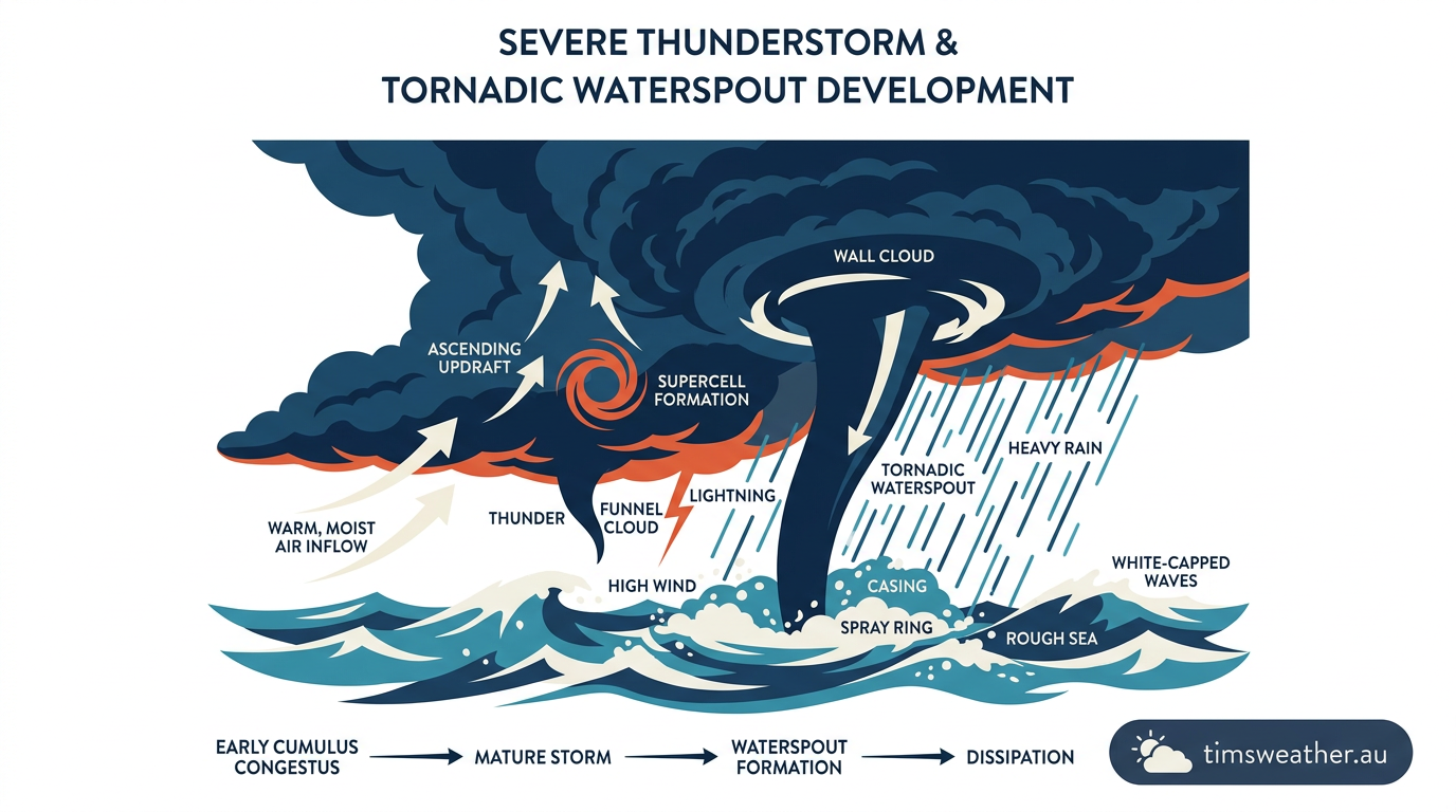
A massive tornadic waterspout dropping from a severe thunderstorm over a rough ocean.
While fair-weather systems are fascinating, tornadic waterspouts present a much higher threat level. These violent vortexes are completely dependent on the severe thunderstorms that spawn them. To grasp their immense power, it helps to review how do thunderstorms form when extreme atmospheric instability is present across a region.
East Coast Lows and supercell environments
In Australia, severe East Coast Lows can generate the immense wind shear required to spin a thunderstorm updraft. As these deep low-pressure systems churn off the coast, they create complex vertical wind profiles. Surface winds might blow strongly from the south, while winds higher in the atmosphere blow from the east. This directional change with height forces the air to roll
Sources
NOAA weather and atmospheric science reference (repository.library.noaa.gov)
NOAA weather and atmospheric science reference (repository.library.noaa.gov)
Waterspouts | Ocean Today (oceantoday.noaa.gov)
NOAA weather and atmospheric science reference (nssl.noaa.gov)
What is a waterspout? (oceanservice.noaa.gov)
NOAA weather and atmospheric science reference (spc.noaa.gov)
Mariners Weather Log Vol. 48, No. 3, December 2004 (vos.noaa.gov)
NOAA weather and atmospheric science reference (repository.library.noaa.gov)
Last verified: 2026-08-17
Frequently asked questions
Waterspouts form when a rotating column of air concentrates over warm water, typically beneath a developing convective cloud. As moist air rises and condenses, the spinning motion tightens into a visible funnel. A patch of spray at the water's surface usually marks the base of the circulation.
Source: weather.gov.hk
Further reading and resources
Explore trusted articles, books, videos and other resources to go deeper on this topic.
weather.govReference
Science - Waterspouts
Background reference on How Do Waterspouts Form? The Complete Meteorological Guide from weather.gov.
en.wikipedia.orgReference
Waterspout
Background reference on How Do Waterspouts Form? The Complete Meteorological Guide from en.wikipedia.org.
ttweathercenter.comArticle
Waterspouts - Trinidad and Tobago Weather Center
In-depth coverage on How Do Waterspouts Form? The Complete Meteorological Guide from ttweathercenter.com.
oceantoday.noaa.govReference
Waterspouts | Ocean Today - NOAA
Background reference on How Do Waterspouts Form? The Complete Meteorological Guide from oceantoday.noaa.gov.
oceanservice.noaa.govReference
What is a waterspout?
Background reference on How Do Waterspouts Form? The Complete Meteorological Guide from oceanservice.noaa.gov.
youtube.comVideo
Waterspout Formation in Caribbean - YouTube
Video coverage on How Do Waterspouts Form? The Complete Meteorological Guide from youtube.com.
education.nationalgeographic.orgArticle
Waterspout - Education | National Geographic Society
In-depth coverage on How Do Waterspouts Form? The Complete Meteorological Guide from education.nationalgeographic.org.
blog.tempest.earthArticle
Waterspouts 101
In-depth coverage on How Do Waterspouts Form? The Complete Meteorological Guide from blog.tempest.earth.
media.bom.gov.auReference
What are waterspouts, and how do they form? - Social Media Blog - BoM
Background reference on How Do Waterspouts Form? The Complete Meteorological Guide from media.bom.gov.au.
hko.gov.hkReference
Waterspout
Background reference on How Do Waterspouts Form? The Complete Meteorological Guide from hko.gov.hk.
Planning weeks ahead?
Check Australia's long-range seasonal outlook for rainfall, temperature and the climate drivers (ENSO, IOD, SAM, MJO) shaping the next three months.
View Australia's Seasonal Weather Forecast