
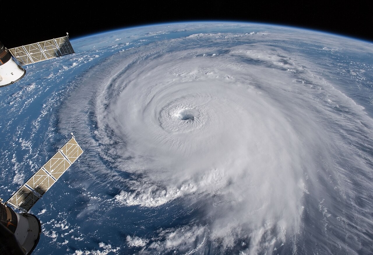
How do hurricanes form? The process begins when warm ocean water above 26.5 degrees Celsius evaporates, providing energy for convection. As moist air rises, it creates low pressure below, drawing in surrounding winds. The Coriolis effect triggers rotation, while low vertical wind shear allows thunderstorms to organise into a closed circulation known as a hurricane.
Key takeaways
Hurricanes require ocean surface temperatures of at least 26.5 degrees Celsius down to a depth of 50 metres to generate sufficient thermal energy.
The release of latent heat during condensation acts as the primary engine driving atmospheric pressure drops.
The Coriolis effect provides the necessary spin, meaning these storms rarely develop within five degrees of the equator.
Strong vertical wind shear can tear a developing system apart by tilting its vertical structure and dispersing its heat.
Atmospheric capping inversions can inhibit storm growth, requiring sustained convection to break through dry air layers aloft.
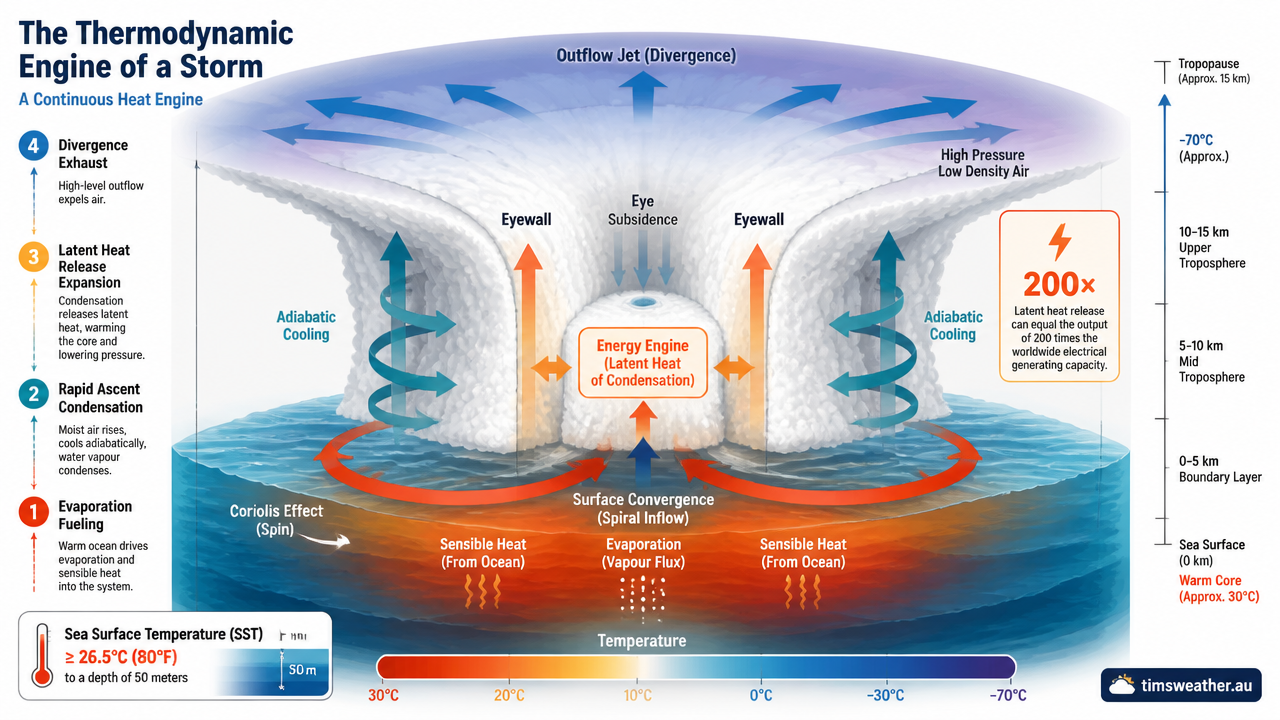
Diagram explaining how do hurricanes form through latent heat release and convection currents over warm ocean waters.
The science behind how hurricanes form
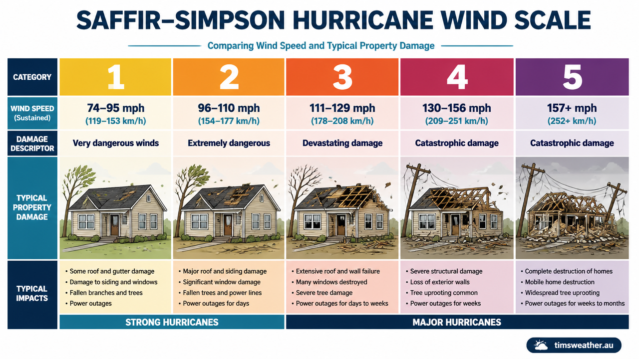
The Saffir-Simpson Hurricane Wind Scale infographic comparing wind speeds and damage levels for categories 1 to 5.
To understand tropical hurricane development, meteorologists look at the ocean and atmosphere as a giant thermodynamic engine. A hurricane is a highly organised weather system that converts the thermal energy of the ocean into mechanical energy in the form of wind. Research by the National Hurricane Center (NHC) and data from the www.nesdis.noaa.gov Hurricane Research Division outline specific thermodynamic thresholds that must be met for this engine to start and sustain itself over open water. When exploring how do tropical cyclones form across different global basins, the fundamental physics remains identical, regardless of whether the system is named a hurricane, typhoon, or cyclone.
As a meteorology educator with advanced academic credentials in atmospheric science, I often explain that the transition from a disorganized cluster of clouds to a mature storm is not random. It is governed by strict laws of thermodynamics and fluid dynamics. Forecasters rely heavily on these principles to predict storm behavior.
The Thermodynamic Engine: How Latent Heat Fuels Hurricanes
The core mechanism driving a hurricane is the latent heat of condensation. As warm ocean water evaporates, it stores energy in the form of water vapour. When this moist air rises into the cooler atmosphere, it condenses back into liquid water droplets to form clouds. This change in state releases the stored energy as sensible heat, warming the surrounding air. This constant cycle of evaporation and condensation is the primary reason these massive storm systems can persist for weeks over open water.
Warm air is less dense and continues to rise rapidly, forming towering convection currents. This upward motion removes mass from the lower atmosphere, causing the surface pressure to drop. The lower the pressure falls, the faster surrounding surface winds rush in to fill the void. These rushing winds increase evaporation at the sea surface, feeding more moisture into the system. This self-sustaining feedback loop continues as long as the storm remains over warm water and encounters favourable atmospheric conditions.
Hydrostatic equilibrium and central pressure drops
In a stable atmosphere, the downward force of gravity is balanced by the upward pressure gradient force, a state known as hydrostatic equilibrium. When intense thunderstorms organise, the massive release of latent heat warms the entire column of air in the core of the storm. Because warm air expands, the pressure surfaces aloft are pushed upward, disturbing this delicate balance. Observers tracking high and low pressure systems on synoptic charts will see this reflected as rapidly falling surface pressure readings near the centre of the storm.
This expansion creates an area of high pressure at the top of the storm compared to the surrounding environment. Air flows outward away from the high pressure aloft, removing mass from the central column faster than surface winds can replace it. This efficient upper-level exhaust system causes the central surface pressure to plummet, intensifying the storm and increasing the pressure gradient force that drives destructive surface winds.
Upper-Level Outflow: The Ventilation System of a Major Hurricane
For a hurricane to strengthen, it must exhaust the rising air that reaches the top of the troposphere. This process is known as upper-level outflow. As the rising air hits the tropopause (the boundary layer between the troposphere and the stratosphere), it can no longer rise because the stratosphere is warmer and highly stable. Instead, the air spreads outward in a vast anticyclonic rotation, meaning it spirals outward and clockwise in the Northern Hemisphere.
This outflow creates the expansive cirrus cloud canopy visible on satellite imagery. If the outflow is restricted by strong upper-level winds or high-pressure systems aloft, the air backs up, and the central surface pressure will stop falling. A strong, unrestricted ventilation system is a key signature of a rapidly intensifying storm.
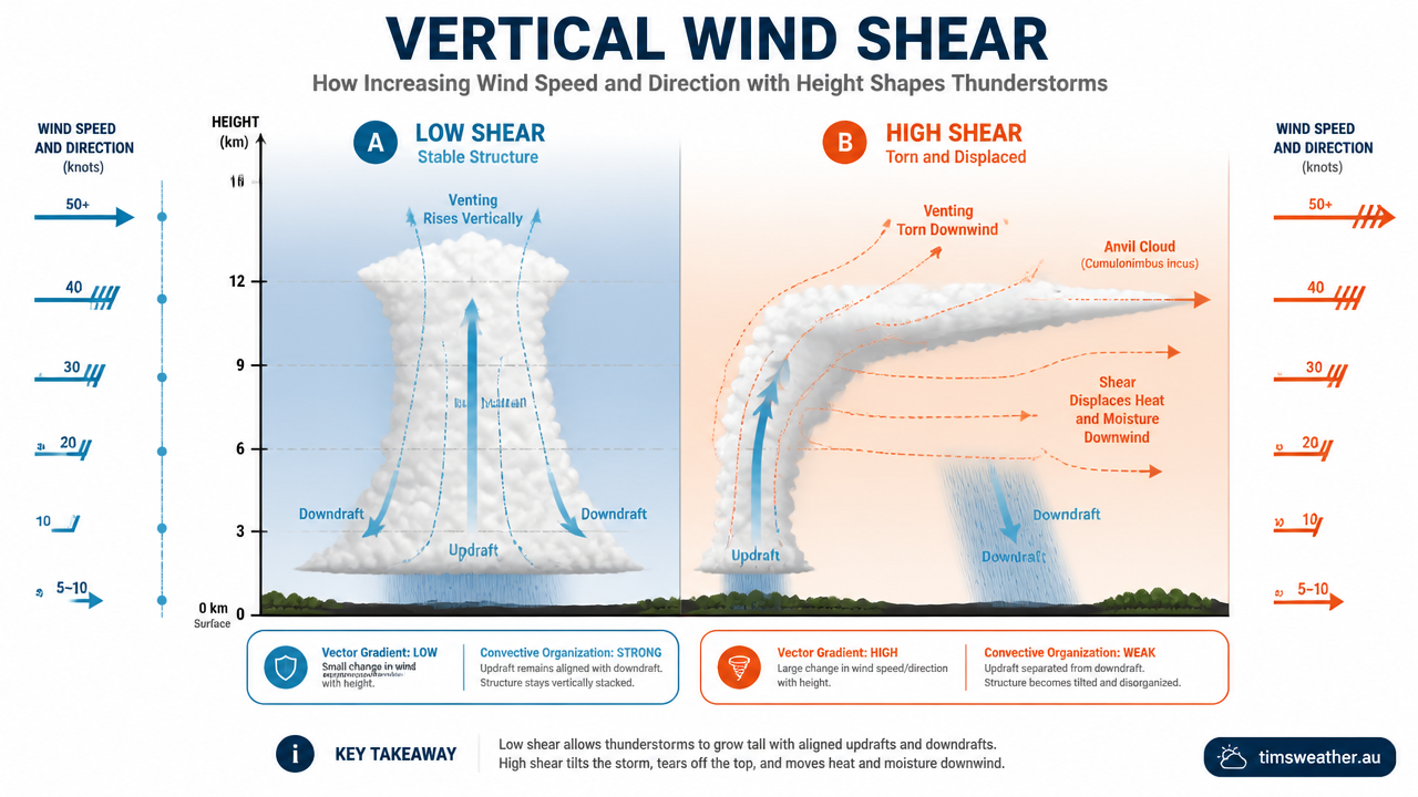
Infographic showing the impact of vertical wind shear on tropical hurricane development and atmospheric pressure systems.
What conditions are needed for hurricanes to form?
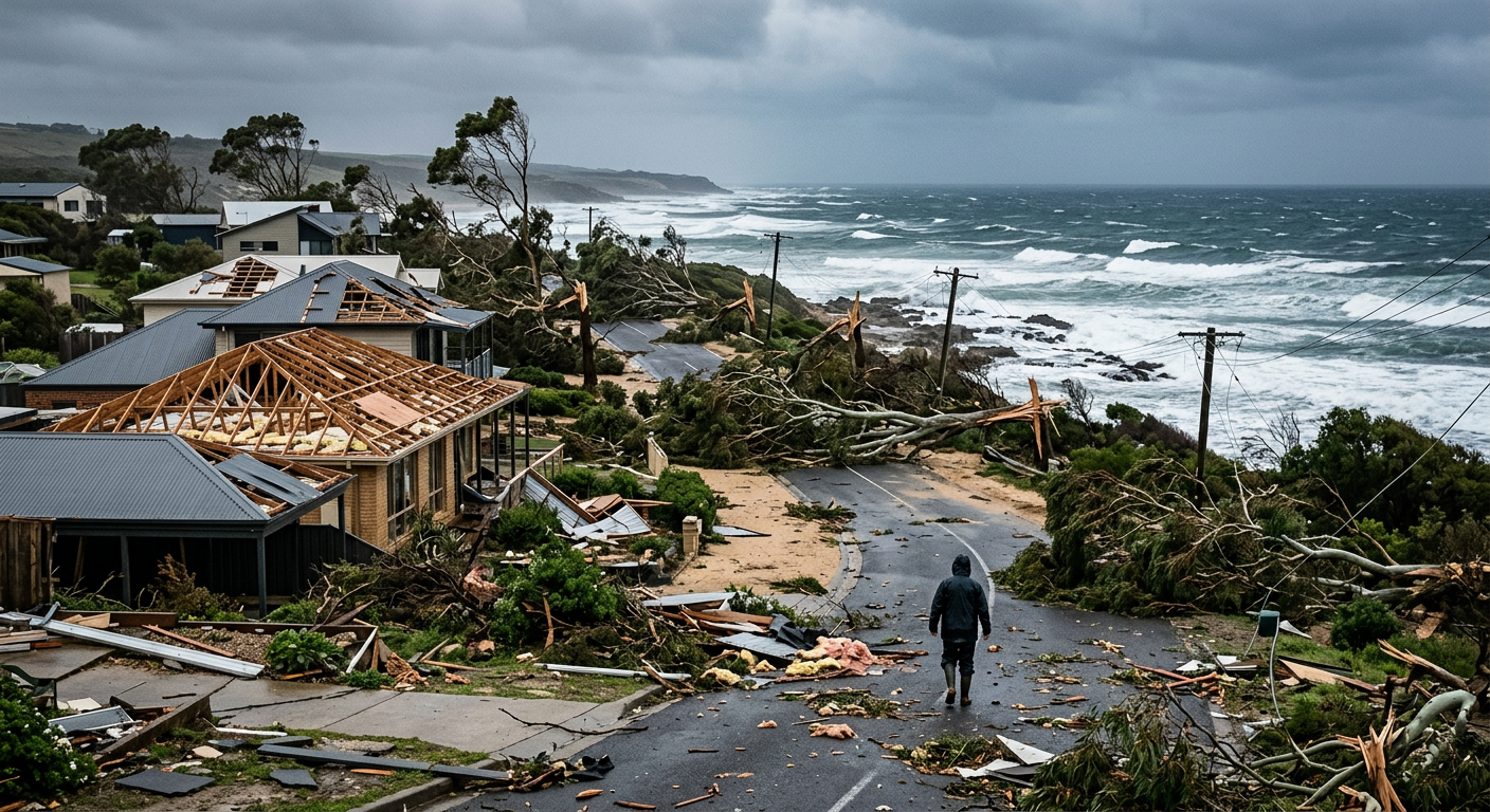
Coastal damage showing snapped trees and missing roofs following an extreme wind event.
Tropical cyclogenesis is not a spontaneous event. Modern meteorological guidance from www.nesdis.noaa.gov emphasises that genesis is probabilistic, requiring several environmental ingredients to overlap in space and time. If any of these elements are missing, a cluster of thunderstorms will fail to organise into a hurricane.
What are the 5 main ingredients for a hurricane to form?
The five main ingredients required for a hurricane to form are warm ocean waters, an unstable atmosphere that allows air to rise, abundant mid-level moisture, sufficient Coriolis force to create rotation, and low vertical wind shear. When these elements align over a pre-existing weather disturbance, a hurricane can begin to develop.
What temperature does the ocean need to be for a hurricane?
Ocean heat is the fundamental fuel source for tropical cyclogenesis. Sea surface temperatures must reach at least 26.5 degrees Celsius (80 degrees Fahrenheit) for a disturbance to thrive. However, surface temperature alone is not enough. This warm water must extend to a depth of roughly 50 to 60 metres to prevent the storm from destroying its own energy source through upwelling.
As a developing storm moves over the ocean, its fierce winds churn the water, mixing the surface layers with cooler water from below. If the warm layer is shallow, this mixing effectively shuts off the storm's energy supply. Data analysis shows that deeper pockets of warm water are associated with explosive intensification, a factor frequently monitored by forecasters. Analyzing recent ECMWF and GFS model output for tropical cyclogenesis case studies often reveals that storms crossing deep warm ocean eddies experience sudden pressure drops.
Atmospheric pressure systems and conditional instability
The troposphere must exhibit conditional instability for deep convection to occur. This means the environmental temperature must decrease rapidly enough with height to allow rising air parcels to remain warmer and more buoyant than their surroundings. Without this instability, updrafts will hit a stable layer and flatten out, severely stunting the convective growth required for hurricane formation.
Also, the mid-levels of the troposphere must be relatively moist. If the surrounding air is too dry, it will mix into the thunderstorm updrafts, causing liquid water droplets to evaporate. Evaporation is a cooling process, which reduces buoyancy and creates strong downdrafts that can choke off a developing storm. How how do cumulonimbus clouds form helps explain why this moisture layer is absolutely necessary for maintaining tall, sustained updrafts.
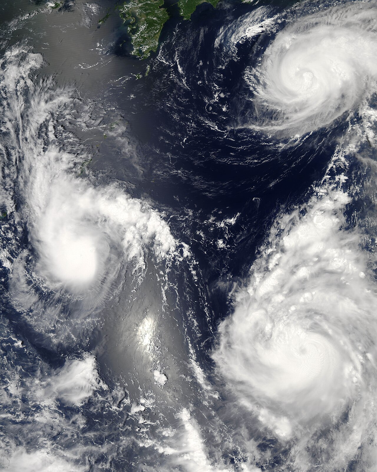
Three tropical cyclones from the 2006 Pacific typhoon season are shown at varying stages of development. The weakest storm (left) displays only a basic circular structure. The more developed system (top right) features spiral rainbands and a more concentrated circulation, while the strongest storm (lower right) has developed a distinct eye. By NASA image by Jeff Schmaltz, MODIS Rapid Response Team, Goddard Space Flight Center. - http://earthobservatory.nasa.gov/NaturalHazards/natural_hazards_v2.php3?img_id=13754, Public Domain, https://commons.wikimedia.org/w/index.php?curid=1031751
Why do hurricanes need the Coriolis effect to rotate?
The Coriolis effect deflects moving air to the right in the Northern Hemisphere and to the left in the Southern Hemisphere, causing storms to spin. Without this deflection, incoming surface winds would rush directly into the low-pressure centre, filling it completely and neutralizing the storm before it could organise into a hurricane.
The Coriolis effect is zero at the equator and increases toward the poles. Consequently, true hurricanes almost never form within five degrees of latitude of the equator. Directly referencing WMO technical documents on tropical hurricane terminology, storms forming near the equator lack the rotational force necessary to generate a closed, spinning circulation.
Low vertical wind shear
Vertical wind shear refers to the change in wind speed or direction with altitude. For a hurricane to develop, vertical wind shear must be weak, generally less than 37 km/h (20 knots). Low shear allows the storm's thunderstorms to remain vertically stacked above the surface low-pressure centre.
If wind shear is too strong, it will tilt the storm's vertical structure. This tilt displaces the latent heat release away from the surface centre, preventing the pressure from dropping. Strong shear also disrupts the storm's upper-level outflow, breaking apart the vital ventilation system that exhausts air away from the storm's core in the upper troposphere.
The capping inversion: why many storms fail to reach hurricane status
Many tropical disturbances move over warm water but fail to develop due to a capping inversion, often associated with the trade wind inversion. This is a layer of warm, dry air located a few kilometres above the surface, created by large-scale sinking air in the subtropics.
This inversion acts as a lid, trapping moisture and heat below it. Thunderstorm updrafts hit this warm layer and lose their buoyancy, spreading out rather than continuing to rise. A disturbance can only overcome a capping inversion if sustained, persistent convection moistens and cools the inversion layer until it erodes entirely, allowing deep convection to break through.
How do hurricanes form step by step?
The transition from a disorganised cluster of clouds to a mature hurricane is a well-documented progression. Meteorological agencies monitor these systems through distinct stages of development, categorising them based on their maximum sustained wind speeds, central barometric pressure, and structural organisation. The IBTrACS historical record for hurricane track analysis provides decades of data mapping exactly how these storms evolve over time.
How do hurricanes form step by step?
How hurricanes form step by step begins when warm ocean water above 80 degrees Fahrenheit evaporates, providing energy for convection. As moist air rises, it creates low pressure below, drawing in surrounding winds. The Coriolis effect triggers rotation, while low vertical wind shear allows the system to organize into a closed circulation known as a hurricane.
Stage 1: The initial tropical disturbance
The hurricane formation process starts with a tropical disturbance, a loosely organised area of thunderstorms that maintains its identity for at least 24 hours. These disturbances often originate as easterly waves, old frontal boundaries, or areas of low-level convergence. At this stage, there is no closed surface circulation, and wind speeds are generally light. The system is entirely reliant on the surrounding environment remaining favourable for continued convection.
Stage 2: Organizing into a tropical depression
If the disturbance remains over warm water and encounters low wind shear, thunderstorms will concentrate and central pressure will fall. When the surface winds begin to rotate completely around the centre, forming a closed circulation, the system is upgraded to a tropical depression. Detailed studies of how do tropical depressions form reveal that maximum sustained winds at this stage are 62 km/h (38 mph) or less. At this point, the system is highly sensitive to environmental changes and can easily dissipate if dry air intrudes.
Stage 3: Strengthening to a tropical storm
As pressure continues to fall, the pressure gradient tightens, causing winds to increase. Once maximum sustained winds reach 63 km/h (39 mph), the system becomes a tropical storm and is given a name by the responsible regional meteorological agency. Convection becomes more concentrated near the centre, and distinct rainbands begin to form, spiralling inward. The system is now extracting massive amounts of energy from the ocean.
Stage 4: Maturing into a hurricane
When maximum sustained winds reach 119 km/h (74 mph), the tropical storm is officially classified as a hurricane. According to documentation from the www.nationalgeographic.com educational archives, this is the stage where the storm typically develops its defining features: a calm eye surrounded by an intense ring of thunderstorms known as the eyewall. The most destructive winds and heaviest rainfall occur within this eyewall.
Stage 5: Rapid intensification and major hurricane status
Under ideal conditions, a hurricane can undergo rapid intensification, defined as an increase in maximum sustained winds of at least 55 km/h (35 mph) in 24 hours. This typically occurs when a storm traverses extremely deep, warm water with very high atmospheric moisture and near-zero wind shear. Famous historic storms like Hurricane Katrina and Hurricane Ian displayed explosive growth in similar conditions. As the storm strengthens into a major hurricane (Category 3 or higher on the Saffir-Simpson Hurricane Wind Scale), it may undergo an eyewall replacement cycle, where an outer ring of thunderstorms forms and eventually chokes off the original inner eye.
Development Stage | Sustained Wind Speed | Core Characteristics | NHC Classification |
|---|---|---|---|
Tropical Disturbance | Less than 38 km/h | Disorganised thunderstorms, no closed circulation | Invest / Disturbance |
Tropical Depression | Up to 62 km/h (38 mph) | Closed surface circulation, weak rotation | Depression (Numbered) |
Tropical Storm | 63 to 118 km/h (39 to 73 mph) | Organised rainbands, concentrated convection | Named Storm |
Hurricane | 119 km/h (74 mph) or higher | Clear eye, defined eyewall, severe wind gradient | Category 1-5 (Saffir-Simpson) |
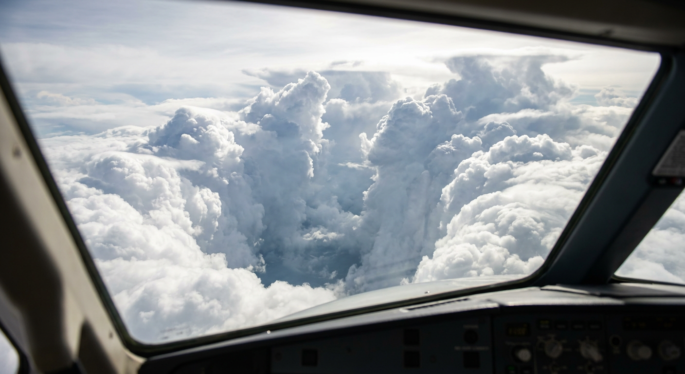
Close-up photograph of the eyewall clouds of a mature storm showing intense vertical convection.
How hurricanes form from tropical waves and the ITCZ
Most tropical cyclones require a pre-existing weather feature to provide the initial spin and low-level convergence necessary to spark thunderstorm development. Over the open ocean, this trigger usually comes from specific atmospheric wave patterns or broad convergence zones tracked heavily by institutions like North Carolina State University during the Atlantic hurricane season.
Easterly waves off the African coast
In the Atlantic Basin, the majority of major hurricanes begin as African easterly waves. These are elongated troughs of low pressure that move from east to west across the deep tropics, embedded in the trade winds. They originate over the African continent, driven by the temperature contrast between the hot, dry Sahara Desert and the cooler, moister regions to the south.
As these waves move westward over the Atlantic Ocean, they create areas of low-level convergence ahead of the wave axis. This convergence forces warm, moist surface air upward, triggering clusters of thunderstorms. If the wave encounters warm sea surface temperatures and low wind shear, it serves as the perfect seed for hurricane formation.
The Intertropical Convergence Zone (ITCZ)
The Intertropical Convergence Zone (ITCZ) is a belt of low pressure circling the globe near the equator, where the trade winds of the Northern and Southern Hemispheres meet. This collision forces air upward, resulting in a nearly continuous band of thunderstorms and heavy rainfall.
While true hurricanes cannot form directly on the equator due to the lack of Coriolis force, sections of the ITCZ can occasionally migrate farther north or south into higher latitudes. When this happens, a cluster of thunderstorms embedded within the ITCZ can begin to spin, eventually breaking away from the main band to become an independent tropical disturbance.
Role of the Saharan Air Layer in inhibiting hurricane growth
Not all tropical waves manage to develop into named storms. One of the primary suppressors of hurricane formation in the Atlantic Basin is the Saharan Air Layer (SAL). This is an intensely dry, dusty, and warm mass of air that originates over the Sahara Desert and frequently sweeps westward across the tropical Atlantic during the peak of the hurricane season.
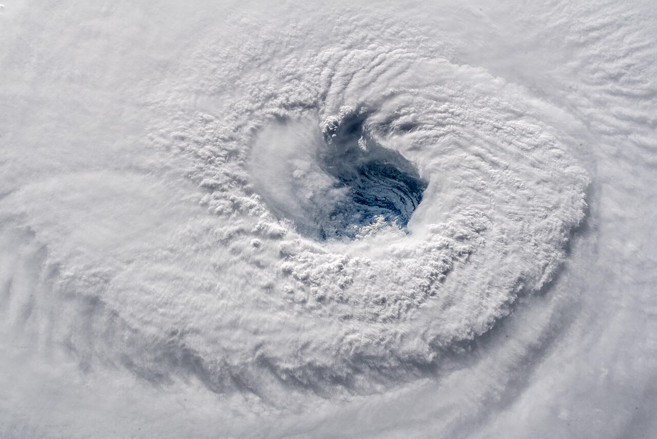
The eye and surrounding clouds of Hurricane Florence seen from the International Space Station. By Alexander Gerst - https://www.nasa.gov/image-feature/staring-down-hurricane-florence, Public Domain, https://commons.wikimedia.org/w/index.php?curid=72686844
Dry air intrusions and stability
The Saharan Air Layer resides just above the cooler, moister marine layer at the ocean surface. Because the SAL is exceptionally warm, it creates a powerful temperature inversion. This stable layer acts like an atmospheric blanket, severely limiting the upward growth of thunderstorm clouds. The dry nature of the SAL is extremely detrimental to a developing storm. If this dry air is entrained into a tropical disturbance, it causes cloud droplets to evaporate rapidly. This evaporation cools the air, making it denser and forcing it to sink rapidly as a downdraft, which effectively crushes the rising convection needed to build a storm.
Why hurricanes weaken over land: loss of moisture vs surface friction
Once a hurricane moves away from its oceanic energy source, its structure begins to collapse. The primary reason for this rapid weakening is the sudden loss of the warm, moist air that fuels the storm's thermodynamic engine. Without the continuous evaporation from the ocean surface, the latent heat release in the eyewall ceases. The central pressure begins to rise, and the fierce winds gradually diminish.
Surface friction over land plays a secondary but noticeable role. The rough terrain of the land increases friction at the surface, slowing down the lowest layer of winds. This disruption forces the surface winds to spiral inward toward the centre much faster than they would over the smooth ocean. This rapid inflow of air fills the low-pressure centre, accelerating the destruction of the pressure gradient that maintains the storm.
Do hurricanes form over cold water?
No, true hurricanes do not form over cold water because they require the massive amounts of latent heat generated by evaporating warm ocean water (at least 26.5 degrees Celsius). When a storm moves over cold water, it loses its primary energy source and either dissipates rapidly or transitions into an extratropical low-pressure system driven by contrasting temperature fronts rather than oceanic heat.
Climate change, ENSO, and hurricane formation trends
The broader climate state plays a significant role in determining how many storms form in a given season. The El Niño Southern Oscillation (ENSO) is a major driver of global atmospheric patterns, directly impacting the frequency of storms in different ocean basins.
El Niño Southern Oscillation impacts
During an El Niño event, waters in the eastern Pacific warm significantly, altering global wind patterns. In the Atlantic Basin, El Niño typically increases vertical wind shear across the tropics. This hostile, high-shear environment tears developing storms apart, often leading to a quieter Atlantic season. Conversely, during La Niña, wind shear in the Atlantic is reduced, creating highly favourable conditions that often result in an active and dangerous hurricane season.
Oceanography experts constantly monitor sea surface temperature anomalies. As global ocean temperatures rise, the geographical areas meeting the 26.5 degrees Celsius threshold are expanding. This expansion allows storms to form earlier in the year, sustain themselves farther north, and undergo rapid intensification more frequently than historical averages suggest.
Frequently asked questions
A hurricane starts over very warm ocean water, usually in the tropics, where moist air rises and thunderstorms cluster around a low-pressure area. This rising air helps the storm organise and intensify as heat is released. In Australia, these systems are referred to as tropical cyclones when they reach maturity.
Source: bom.gov.au
Further reading and resources
Explore trusted articles, books, videos and other resources to go deeper on this topic.
weather.govReference
Hurricane Facts
Background reference on How Do Hurricanes Form? The Complete Meteorological Guide from weather.gov.
emergency.fsu.eduReference
Tropical Storms & Hurricanes: The Basics - Emergency Management
Background reference on How Do Hurricanes Form? The Complete Meteorological Guide from emergency.fsu.edu.
scied.ucar.eduReference
How Hurricanes Form - UCAR Center for Science Education
Background reference on How Do Hurricanes Form? The Complete Meteorological Guide from scied.ucar.edu.
youtube.comVideo
How Do Hurricanes Form?
Video coverage on How Do Hurricanes Form? The Complete Meteorological Guide from youtube.com.
noaa.govReference
Hurricanes | National Oceanic and Atmospheric Administration - NOAA
Background reference on How Do Hurricanes Form? The Complete Meteorological Guide from noaa.gov.
belfor.comArticle
How Do Hurricanes Form: From Ocean Heat To Storm Systems
In-depth coverage on How Do Hurricanes Form? The Complete Meteorological Guide from belfor.com.
kids.nationalgeographic.comArticle
Hurricanes | National Geographic Kids
In-depth coverage on How Do Hurricanes Form? The Complete Meteorological Guide from kids.nationalgeographic.com.
ametsoc.orgArticle
Tropical Cyclone Forecasting in the United States
In-depth coverage on How Do Hurricanes Form? The Complete Meteorological Guide from ametsoc.org.
climatechange.ieArticle
How do hurricanes form? A step-by-step guide. - Climate Change
In-depth coverage on How Do Hurricanes Form? The Complete Meteorological Guide from climatechange.ie.
spaceplace.nasa.govReference
How Do Hurricanes Form?
Background reference on How Do Hurricanes Form? The Complete Meteorological Guide from spaceplace.nasa.gov.
Planning weeks ahead?
Check Australia's long-range seasonal outlook for rainfall, temperature and the climate drivers (ENSO, IOD, SAM, MJO) shaping the next three months.
View Australia's Seasonal Weather Forecast