
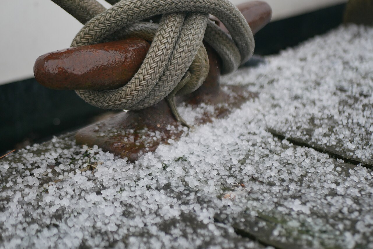
How does hail form begins when strong convective updrafts carry water droplets above the freezing level into the upper reaches of a cumulonimbus cloud. These droplets become supercooled and freeze onto ice embryos. The hailstones grow in concentric layers as they circulate through the storm before gravity eventually overcomes the updraft.
Key takeaways
- Hail requires deep convective storms where violent updrafts keep ice suspended long enough to accumulate mass.
- The growth process usually begins with a hailstone embryo, such as graupel, which collects supercooled water droplets.
- Storms with a rotating mesocyclone, like supercells, produce the largest hailstones because they sustain updrafts for longer periods.
- The freezing level, atmospheric instability, and convective inhibition determine whether a storm can produce giant hail.
- When a hailstone becomes too heavy for the upward air currents, its terminal velocity causes it to fall to the earth.
How does hail form in a convective storm?
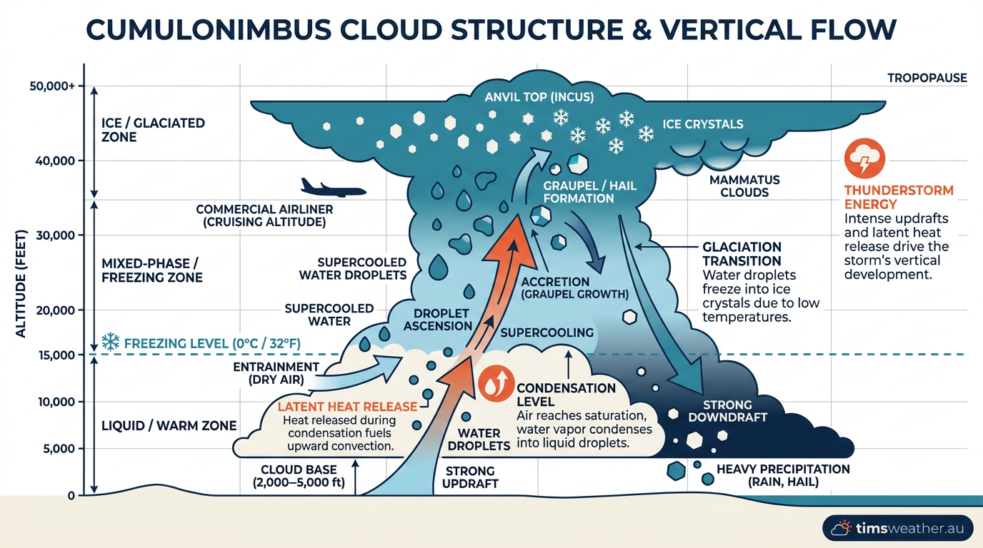
Hail forms inside deep thunderstorms when air is forced upward rapidly enough to push liquid water into sub-zero regions of the atmosphere. Official definitions from the WMO International Cloud Atlas classify hail as pieces of ice 5 mm or larger in diameter, distinguishing it from smaller ice pellets. The recipe for hail involves intense atmospheric instability, abundant moisture, and a mechanism to force that moist air upward into cold high-altitude environments.
The process starts when surface heating or weather boundaries trigger deep convection. As warm air rises, it expands and cools, condensing into a cumulonimbus cloud. Within these towering clouds, powerful vertical winds lift raindrops into cold areas of the atmosphere where temperatures drop well below 0°C. However, the water does not freeze instantly. Instead, it becomes a supercooled water droplet, meaning it remains liquid despite being below freezing point. These droplets are highly unstable and will freeze the moment they contact a solid object.
What causes hail to fall instead of rain?

Hail falls instead of rain when a thunderstorm has updrafts strong enough to keep water suspended above the freezing level long enough to form solid ice. If the updrafts are weak, the frozen particles remain small and melt as they fall through warmer air near the ground, reaching the surface as cold rain. Only when the ice chunks grow large enough to survive the descent do they fall as hail.
To reach significant sizes, the storm must first create a hailstone embryo. This embryo often begins as a frozen raindrop or graupel (a soft, opaque snow pellet coated in rime ice). As this embryo is tossed around inside the storm by turbulent air currents, it collides with millions of supercooled water droplets. Each collision adds a new film of water that freezes onto the existing core, slowly building the stone layer by layer. For a broader understanding of how these towering clouds generate severe weather, see our guide on cumulonimbus clouds.
The role of supercell thunderstorms and mesocyclones
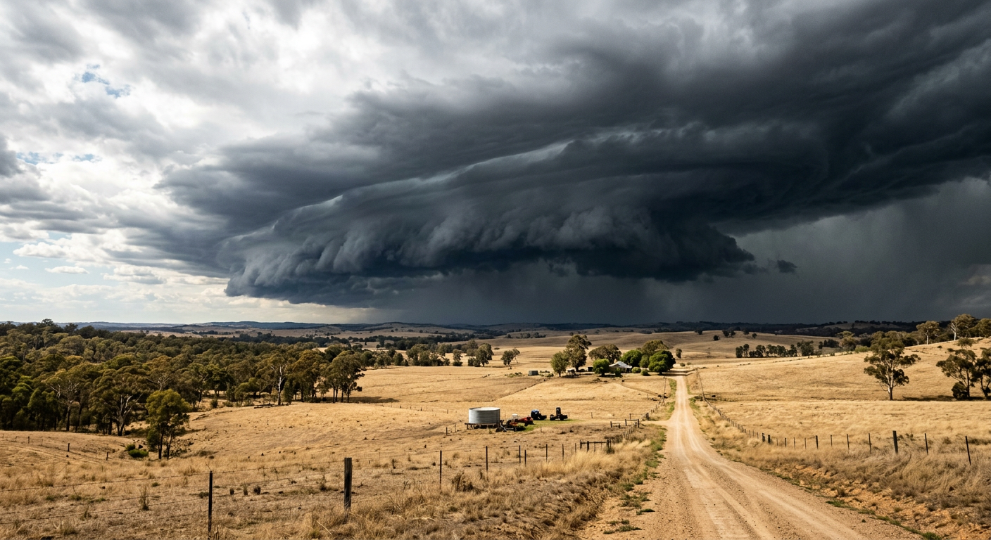
While a brief, single-cell summer storm can produce small hail, generating large or giant hail requires a highly organised atmospheric structure. The most prolific producers of destructive hail are supercell thunderstorms. These storms are characterised by a rotating updraft known as a mesocyclone. The rotation helps separate the rising warm air (the updraft) from the sinking cold air (the downdraft), allowing the storm to survive for hours without choking on its own rain-cooled air.
Because the updraft in a supercell is tilted by wind shear, hailstones can fall out of the highest part of the cloud, get caught in the rising inflow air, and be thrown back into the freezing zone. According to NOAA National Severe Storms Laboratory (NSSL) research data, creating stones larger than 50 mm requires extreme vertical wind speeds. Giant hailstones often require updraft speeds of 257 to 290 km/h to remain suspended against the force of gravity.
How do updrafts affect hail size?
Updrafts directly control how large a hailstone can grow. The faster the air moves upward, the heavier the ice must become before gravity can pull it down. A weak updraft of 35 km/h can only support pea-sized hail, whereas violent supercell updrafts can support hailstones the size of cricket balls before their terminal velocity finally overcomes the upward wind.
How many times does a hailstone go up and down in a cloud?
A classic meteorological concept known as From Embryo to Giant Hail: The Physics of Multiple Ascents explains that hailstones do not simply ride up and down like a yo-yo. Instead, they typically make one or two slow, looping journeys through different temperature zones in the storm's core. The stone is swept upward, drifts horizontally, falls slightly into the main updraft zone, and gets lofted again, collecting supercooled water continuously along its varied flight path.
Deciphering Hailstone Layers: A Frozen Timeline of Storm Intensity
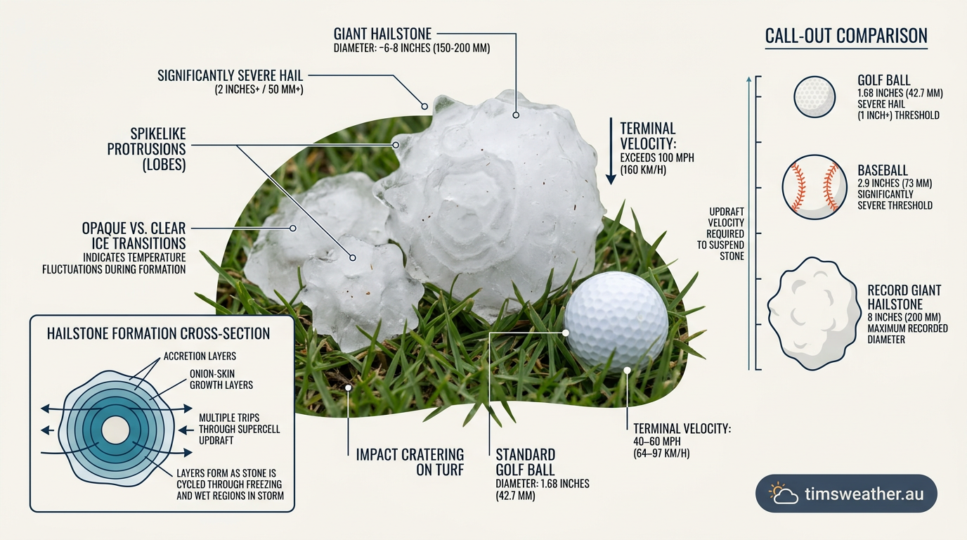
If you cut a large hailstone in half, you will often see alternating rings of clear and opaque ice. Deciphering Hailstone Layers: A Frozen Timeline of Storm Intensity reveals exactly what conditions the stone experienced during its journey through the cloud. Meteorologists perform hailstone cross-section analysis using polarized light to study these layers, matching them to specific altitudes and temperatures within the storm.
These distinct rings form due to two different freezing processes: dry growth and wet growth. When a hailstone passes through a very cold region of the cloud (often below -20°C) with a lower concentration of supercooled water, the droplets freeze immediately upon impact. This rapid freezing traps tiny air bubbles, creating a milky or opaque layer of ice known as the dry growth phase.
Conversely, if the hailstone travels through a slightly warmer section of the cloud (between 0°C and -10°C) with massive amounts of liquid water, the droplets do not freeze instantly. The water spreads over the surface of the hailstone as a thin liquid film before slowly freezing. This allows trapped air bubbles to escape, forming a layer of hard, transparent ice. This is called the wet growth phase.
The wet-bulb temperature is critical in this process. It represents the lowest temperature to which air can be cooled by the evaporation of water. A lower wet-bulb temperature in the mid-levels of the atmosphere enhances evaporative cooling, ensuring the hailstone remains frozen as it descends. Also, the presence of convective inhibition (a stable layer or "cap" of warm air above the surface) can prevent widespread rain, allowing pressure and heat to build until the cap breaks. The resulting explosive convection provides the violent updrafts required for maximum wet and dry growth.
Global extremes and Australian hail patterns
Severe hail is a global phenomenon, but it is heavily influenced by local geography. Around the world, meteorologists classify hail sizes ranging from quarter-sized to gargantuan, with stones over 10 centimetres causing catastrophic damage. This was clearly demonstrated when hailstones exceeding 12 centimetres in a recent Illinois storm shattered windshields and destroyed roofs across the midwestern United States.
In Australia, severe hailstorms are most frequent along the east coast. The "Hailstorm Alley" region stretching across South East Queensland and northern New South Wales provides a perfect atmospheric laboratory. The unique atmospheric profile of the Australian Great Dividing Range forces warm, moist air from the Pacific Ocean to rise sharply when it meets cold, dry westerly winds aloft. This collision creates immense Convective Available Potential Energy (CAPE), fueling explosive storm growth.
The 1999 Sydney hailstorm remains a stark example of this power. Producing stones measuring up to 9 by 11 centimetres, it became the costliest natural disaster in the nation's history, highlighting the massive impact of Australian Bureau of Statistics storm damage costs on the insurance industry. Unlike tropical downpours from systems like Cyclone Jasper in 2023, which primarily cause damage through sustained winds and flooding, supercell hail causes immediate, intense structural destruction.
Why is hail more common in summer than winter in Australia?
Hail is more common in summer because intense surface heat is required to generate strong updrafts. During the Australian spring and summer, intense solar heating warms the ground, creating highly unstable air that rises rapidly. This rising warm air interacts with cold upper-level troughs. The Role of the Freezing Level in Australian Summer Storms is vital here: although ground temperatures are hot, the freezing level remains high enough to allow deep, powerful cumulonimbus clouds to form, giving hailstones ample space to grow before they fall through the warm layer to the surface.
Another factor is How Wind Shear Influences Hail Size in Queensland Supercells. Strong changes in wind direction and speed with height (shear) help separate the storm's updraft from its downdraft, sustaining the life of the mesocyclone and allowing hailstones to undergo multiple growth cycles.
Radar detection and severe weather warnings
Detecting hail before it hits the ground is a primary task for meteorological agencies. The Bureau of Meteorology (BOM) and international weather services rely heavily on advanced radar systems to issue severe thunderstorm warnings. Because solid ice reflects radar energy differently than liquid rain, the hail core is highly reflective on radar screens, appearing as bright purple or white patches within the storm structure.
Modern dual-polarisation radar systems emit both horizontal and vertical radio pulses. Since large raindrops flatten out into burger shapes as they fall, they return a stronger horizontal signal. Hailstones, however, tumble as they fall and are roughly spherical or irregularly shaped, returning similar horizontal and vertical signals. This difference allows meteorologists to pinpoint exactly where the hail is falling inside a dark cloud.
What determines the final size of a hailstone?
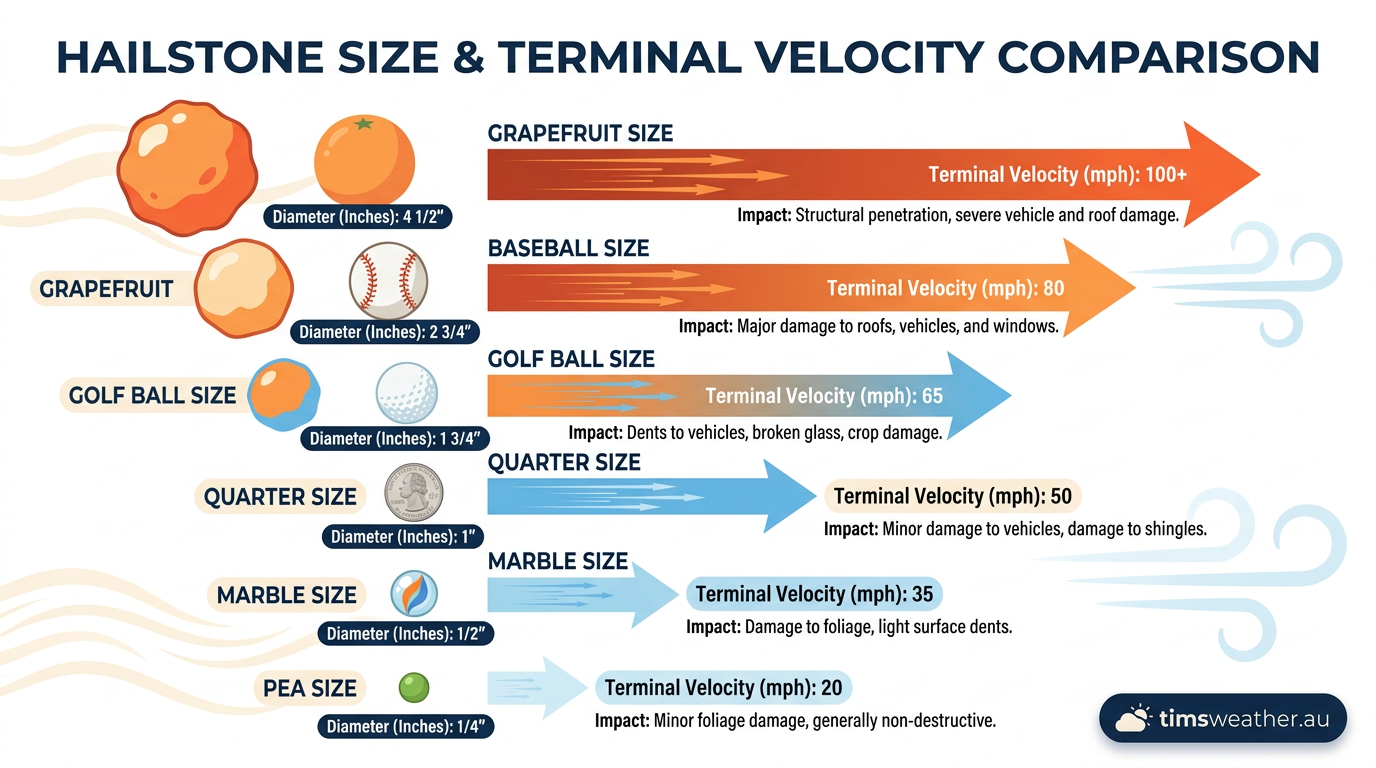
The final size of a hailstone is determined by the maximum strength of the storm's updraft minus the amount of ice that melts as the stone falls below the freezing level. Even if a storm produces giant hail at 8,000 metres altitude, a high freezing level and a long drop through warm, humid air can melt the stones entirely into heavy rain before they reach the ground.
| Hail Diameter (mm) | Comparison Object | Estimated Terminal Velocity (km/h) | Typical Damage Level |
|---|---|---|---|
| 10 to 15 | Pea or Macadamia nut | 35 to 50 | Minor leaf damage, stripped vegetation. |
| 25 to 35 | 10-cent piece or Walnut | 60 to 75 | Dented car panels, bruised fruit crops. |
| 50 to 70 | Golf ball or Tennis ball | 90 to 110 | Broken roof tiles, smashed windshields, danger to life. |
| 100+ | Melon or Grapefruit | 140 to 160+ | Catastrophic structural damage, lethal impacts. |
Recognising the warning signs of severe weather is essential. Dark, greenish-black clouds, a sudden drop in temperature, and the sound of distant roaring are all indicators of an approaching hail core. For more information on identifying severe weather features, read our guide on types of severe thunderstorms in Australia and the mechanics of downbursts that often accompany heavy hail.
Frequently asked questions
Hail forms inside large cumulonimbus clouds when powerful updrafts carry raindrops into freezing air high in the atmosphere. These droplets become supercooled and freeze onto ice particles. As they circulate within the storm, they collect more layers of ice until they are heavy enough to fall to the ground.
Source: bom.gov.au
Further reading and resources
Explore trusted articles, books, videos and other resources to go deeper on this topic.
youtube.comVideo
How does hail form?
Video coverage on How Does Hail Form? The Science of Thunderstorms and Giant Ice from youtube.com.
cnn.comArticle
How does hail form?
In-depth coverage on How Does Hail Form? The Science of Thunderstorms and Giant Ice from cnn.com.
scied.ucar.eduReference
Why Does Hail Happen? - UCAR Center for Science Education
Background reference on How Does Hail Form? The Science of Thunderstorms and Giant Ice from scied.ucar.edu.
en.wikipedia.orgReference
Hail
Background reference on How Does Hail Form? The Science of Thunderstorms and Giant Ice from en.wikipedia.org.
wkbw.comArticle
The science behind how hail forms in a thunderstorm, and ...
In-depth coverage on How Does Hail Form? The Science of Thunderstorms and Giant Ice from wkbw.com.
How Hail is Made in Storms | Center for Science Education
Background reference on How Does Hail Form? The Science of Thunderstorms and Giant Ice from scied.ucar.edu.
Hail
Background reference on How Does Hail Form? The Science of Thunderstorms and Giant Ice from en.wikipedia.org.
smithsonianmag.comArticle
Giant, Destructive Hail Is Becoming More Common With Climate ...
In-depth coverage on How Does Hail Form? The Science of Thunderstorms and Giant Ice from smithsonianmag.com.
bbc.comArticle
How climate change is leading to bigger hailstones - BBC
In-depth coverage on How Does Hail Form? The Science of Thunderstorms and Giant Ice from bbc.com.
earthnetworks.comArticle
All About Hail: A Severe Weather Guide - Earth Networks
In-depth coverage on How Does Hail Form? The Science of Thunderstorms and Giant Ice from earthnetworks.com.
Planning weeks ahead?
Check Australia's long-range seasonal outlook for rainfall, temperature and the climate drivers (ENSO, IOD, SAM, MJO) shaping the next three months.
View Australia's Seasonal Weather Forecast