

How does radiation fog form? It forms on clear, calm nights when the ground loses heat through terrestrial radiation. That cooling lowers the air beside the surface to its dew point temperature, so water vapour condenses into tiny droplets. A temperature inversion then helps trap that saturated air near the ground, building a fog layer.
Key takeaways
- Radiation fog forms after the ground cools quickly on clear nights through long-wave radiation loss.
- Calm winds help keep cold air pooled near the surface by reducing mixing in the boundary layer.
- For safety in Australian valleys, slow down and use low beam headlights when this type of ground-level cloud forms.
- Relative humidity reaches 100 per cent as near-surface air cools to the dew point temperature.
- Radiation fog differs from advection fog, which forms when moist air moves over a colder surface.
The step-by-step process: how does radiation fog form?
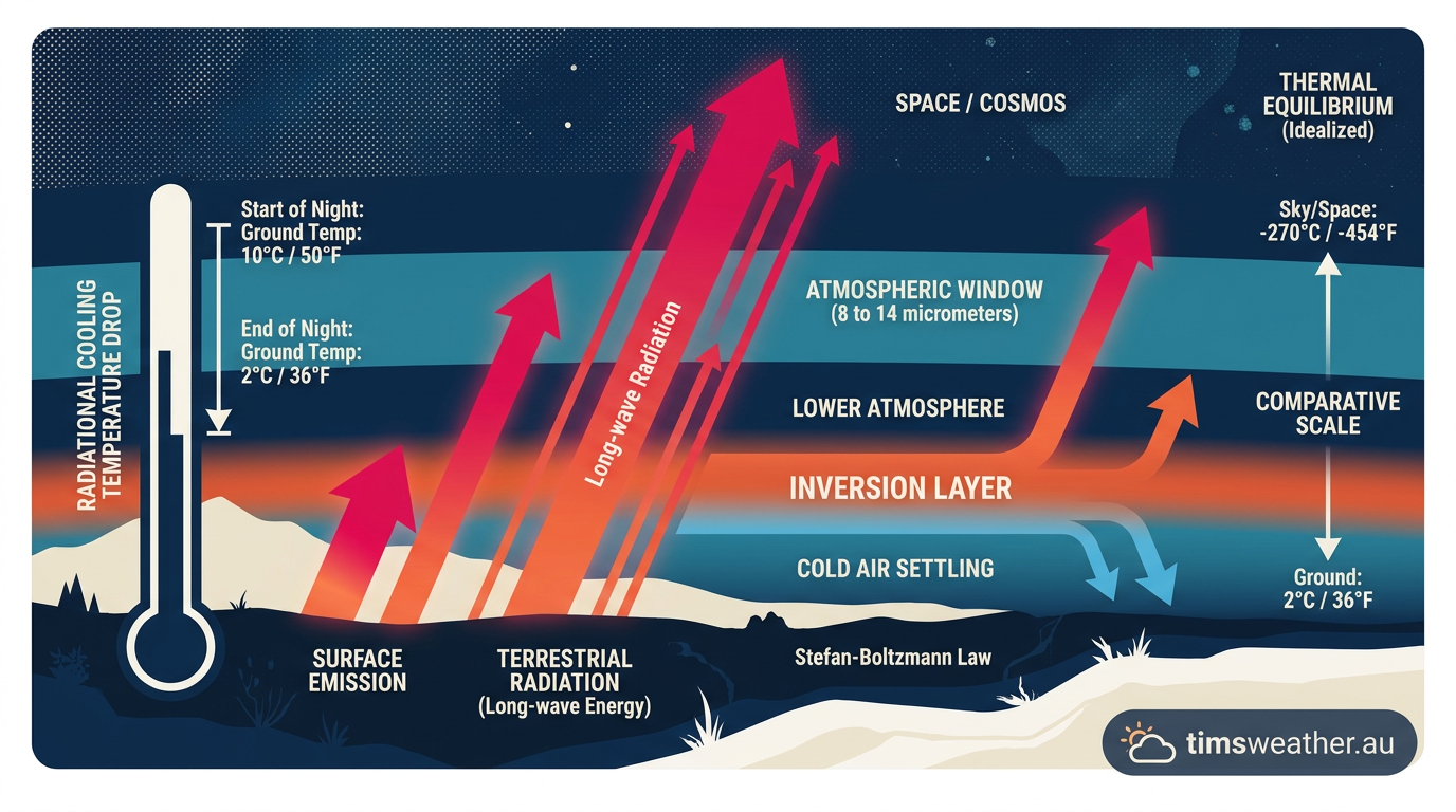
Radiation fog develops through night-time thermal cooling at the surface. By day, the ground absorbs short-wave energy from the sun. After sunset, that input stops and the surface begins to lose stored heat as long-wave radiation. Meteorologists call this radiative cooling.
As the surface cools, the air just above it cools too. Warmer air can hold more water vapour than colder air, so the near-surface layer edges towards saturation. Once it reaches the dew point temperature, relative humidity reaches 100 per cent and tiny droplets can form. That is the start of fog. The planetary boundary layer, the lowest part of the atmosphere, is where this usually happens.
Fog is defined as a cloud of water droplets near ground level that reduces visibility to less than 1,000 metres (Britannica). Radiation fog often begins as a shallow layer close to the surface, then deepens if the air stays moist enough. For Australian forecasts and warnings, check the Bureau of Meteorology (BOM).
The role of terrestrial radiation and thermal cooling
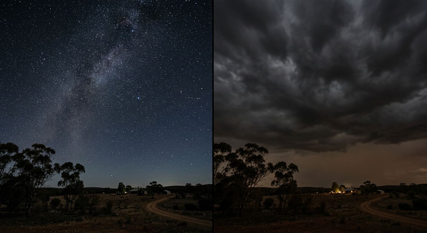
Terrestrial radiation is the heat the Earth emits back to space. On clear nights, there is little cloud to absorb and re-emit that energy, so the ground cools quickly. That is why clear skies are such a strong setup for fog formation.
In Australia, inland valleys and sheltered basins often cool faster than nearby slopes because the coldest air drains downhill and pools in low spots. This is the basic idea behind The Role of Australian Topography in Radiative Cooling: terrain can speed up surface cooling by collecting dense, cold air where it cannot mix out easily. For people in those spots, fog can form in the lowest hours before sunrise.
Condensation and the role of hygroscopic nuclei
Water vapour needs tiny particles to condense onto. These are called condensation nuclei, and many of them are hygroscopic nuclei, which attract water. Sea salt, dust, smoke and other aerosols can all serve this role. Once the air reaches saturation, droplets grow on these particles and the fog becomes visible.
The number and type of particles in the air can affect how readily fog thickens, but the key trigger is still cooling to the dew point. A moist, stable surface layer with enough nuclei is a good fog setup, especially when the relative humidity is already high before sunrise.
Why calm winds matter in the boundary layer
Calm winds are one of the main ingredients for radiation fog. Light winds reduce turbulent mixing, so the coldest air stays near the surface instead of being mixed with warmer air above. In a stable atmosphere, that surface layer can keep cooling until it reaches saturation.
If winds are too strong, they stir the lower atmosphere and disrupt the fog setup. That extra mixing brings in slightly warmer, drier air from above and can stop the air from reaching its dew point. This is why radiation fog is far more common on still mornings than on breezy ones.
There is a difference between a calm night and a complete glass-out. A slight breeze can sometimes spread fog around a wider area, but once winds pick up enough to break the inversion layer, the fog usually thins or lifts.
Why does radiation fog only form on clear nights?
Clear skies let the surface lose heat efficiently. With little cloud cover, outgoing long-wave radiation escapes more freely, so nocturnal cooling is stronger. That sharp drop in surface temperature is what pushes the air towards saturation.
Clouds work against this process. They absorb some of the Earth’s outgoing heat and send part of it back down, which slows the temperature drop near the ground. In practical terms, a cloudy night is much less likely to produce radiation fog than a clear one.
Temperature inversion explained
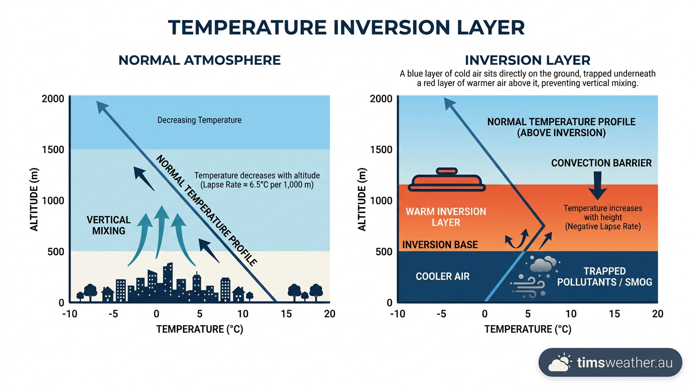
A temperature inversion means temperature increases with height for a shallow layer, instead of dropping with height as it usually does. When cold air sits under warmer air, the lower atmosphere becomes capped. That cap is the inversion layer, and it helps keep moist air close to the ground.
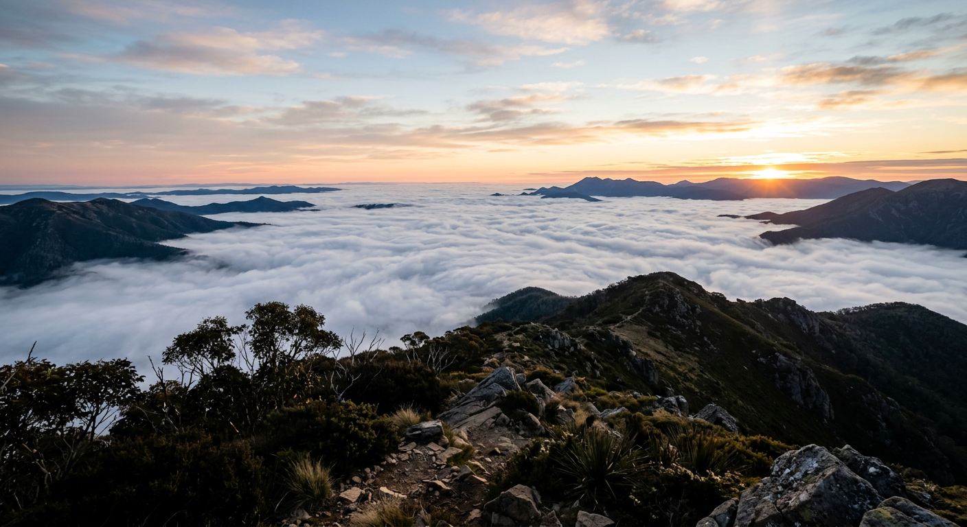
This structure is why radiation fog often looks like a flat white blanket. The air below the inversion stays cool, dense and moist, while the air above is warmer and more stable. Once the fog forms, it can linger until sunrise and then clear as solar heating rebuilds mixing in the boundary layer.
Radiation fog vs advection fog
Radiation fog and advection fog can look similar, but they form in different ways. Radiation fog is a local cooling event. Advection fog forms when moist air moves horizontally over a colder surface, such as cold water or chilled ground.
| Fog type | Main trigger | Typical weather setup | Common Australian setting |
|---|---|---|---|
| Radiation fog | Night-time surface cooling | Clear skies, calm winds, stable air | Inland valleys, basins and sheltered plains |
| Advection fog | Moist air moves over a colder surface | Airflow over cooler land or water | Coastal zones and marine-influenced areas |
If you want a plain-language comparison, advection fog comparison is the main one forecasters use when explaining why one fog event forms overnight and another drifts in with the wind.
Where fog forms most often in Australia
Radiation fog is common in sheltered inland areas, especially where cold air can pool overnight. Valleys, basins and low-lying floodplains often cool faster than exposed ridges. That is why fog can be patchy, with thick banks in one spot and clearer air a few kilometres away.
Topography matters because it shapes drainage flow and local cooling. If you are in a valley in eastern Australia on a clear winter morning, fog can arrive fast and visibility can drop in minutes. The safest move is to slow down early and use low beam headlights.
How to read a fog setup
For a likely radiation fog night, look for a simple mix: clear skies, light winds, moist ground, and a cooling surface layer near the dew point. If the evening starts with high humidity, the air does not need much extra cooling before fog forms.
- Check overnight minimum temperatures and the forecast wind speed.
- Look for clear skies and weak mixing in the boundary layer.
- Watch for a cold, stable air mass settling in valleys or low plains.
- Expect fog to form first in the coldest spots, then spread if moisture is deep enough.
For more on moisture checks, see dew point vs humidity and visibility. If you are forecasting for aviation or road travel, the dew point spread is often the quickest clue.
Related guides
Frequently asked questions
Radiation fog forms when the ground loses heat overnight through long-wave radiation, cooling the air immediately above it to its dew point. If the air contains enough moisture, water vapour condenses into tiny liquid droplets near the surface. This process requires clear skies and very light winds to succeed.
Source: geo.libretexts.org
Further reading and resources
Explore trusted articles, books, videos and other resources to go deeper on this topic.
britannica.comReference
Radiation fog | meteorology
Background reference on How Does Radiation Fog Form? Atmospheric Cooling Explained from britannica.com.
weather.govReference
Radiation Fog
Background reference on How Does Radiation Fog Form? Atmospheric Cooling Explained from weather.gov.
rainviewer.comArticle
How Does Fog Form? The Mystery of Fog Explained
In-depth coverage on How Does Radiation Fog Form? Atmospheric Cooling Explained from rainviewer.com.
climavision.comArticle
5 Types of Fog and How They Form
In-depth coverage on How Does Radiation Fog Form? Atmospheric Cooling Explained from climavision.com.
How Fog Forms
Background reference on How Does Radiation Fog Form? Atmospheric Cooling Explained from weather.gov.
ebsco.comArticle
Fog and regulation of the global climate
In-depth coverage on How Does Radiation Fog Form? Atmospheric Cooling Explained from ebsco.com.
boldmethod.comArticle
The 6 Types Of Fog
In-depth coverage on How Does Radiation Fog Form? Atmospheric Cooling Explained from boldmethod.com.
en.wikipedia.orgReference
Fog
Background reference on How Does Radiation Fog Form? Atmospheric Cooling Explained from en.wikipedia.org.
pilotinstitute.comArticle
The 7 Types of Fog Every Pilot Should Know
In-depth coverage on How Does Radiation Fog Form? Atmospheric Cooling Explained from pilotinstitute.com.
resources.eumetrain.orgArticle
Radiation Fog Theory
In-depth coverage on How Does Radiation Fog Form? Atmospheric Cooling Explained from resources.eumetrain.org.
Planning weeks ahead?
Check Australia's long-range seasonal outlook for rainfall, temperature and the climate drivers (ENSO, IOD, SAM, MJO) shaping the next three months.
View Australia's Seasonal Weather Forecast