
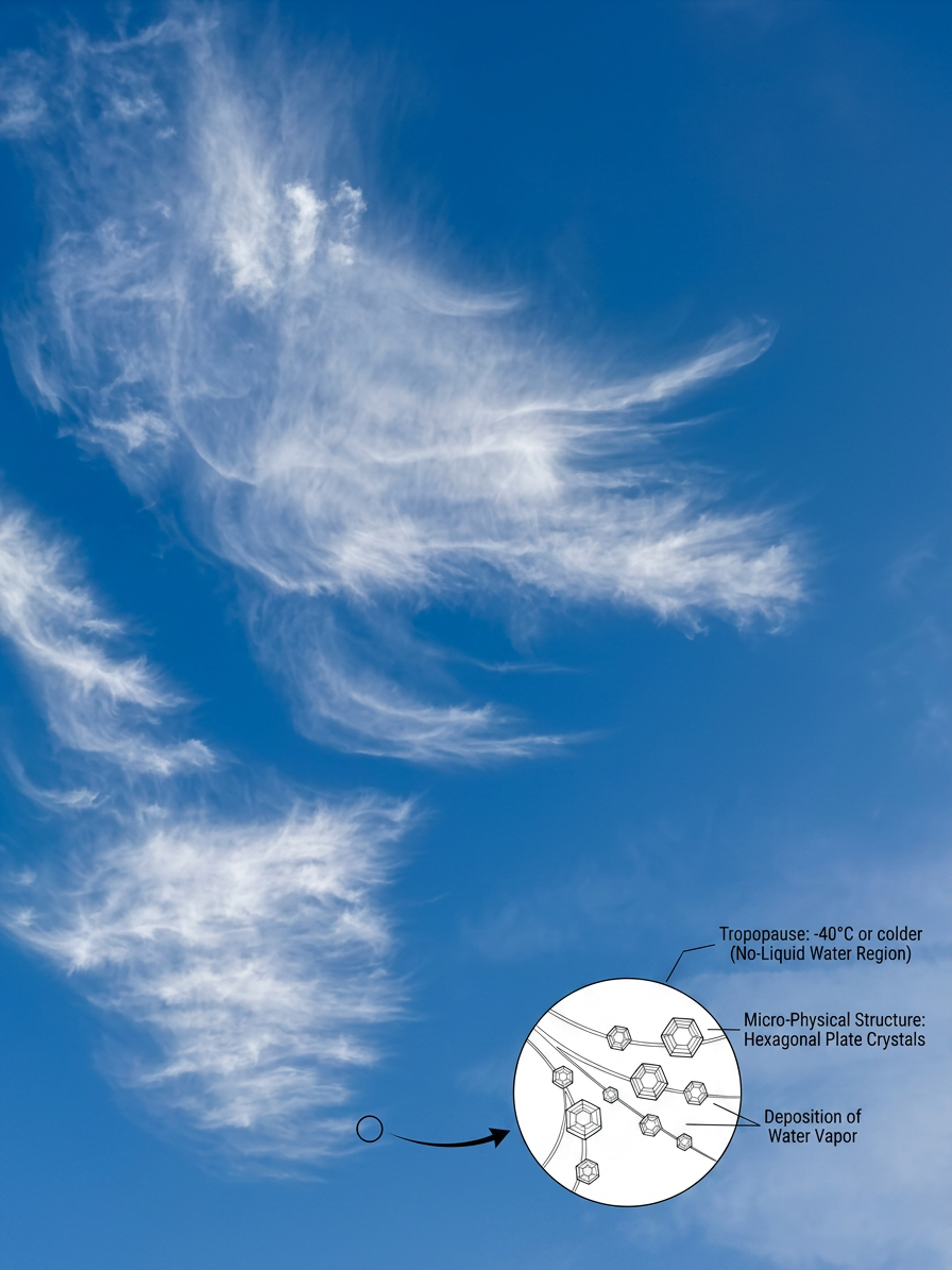
How do cirrus clouds form? The process is driven by the deposition of atmospheric water vapour directly into ice crystals within the cold upper troposphere. Typically occurring above 6,000 metres, these wispy formations develop when air reaches supersaturation and are often stretched across the sky by fast-moving jet streams.
Key takeaways
- In northern Australia, tropical cyclone outflow spreads ice crystals far from the storm, which helps build high-cloud layers.
- Ice crystal formation often starts through heterogeneous nucleation on dust or soot, but homogeneous nucleation can also occur in very cold air.
- Thunderstorms can send ice crystals outward in convective outflow, leaving cirrus spissatus and thinner cirrus bands behind.
- Jet stream winds stretch cirrus into long streaks and can spread them far from the source cloud.
- Cirrus clouds affect radiative forcing by letting much of the Sun’s energy through while trapping some outgoing heat.
The core science of how do cirrus clouds form
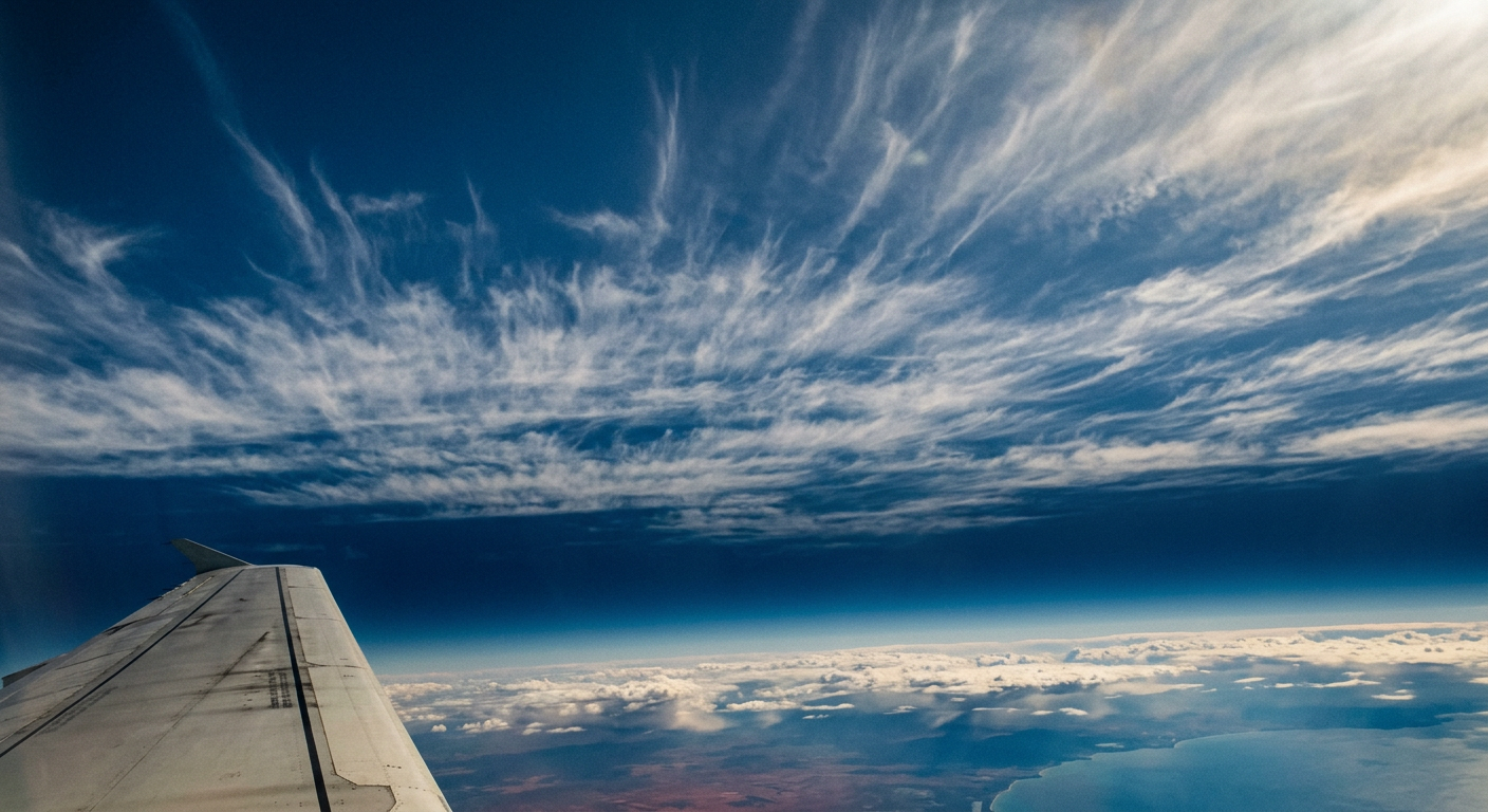
Cirrus are high-altitude clouds made mostly of ice crystals. NOAA’s cloud guide places cirrus in the high-cloud group, and that matches what forecasters in Australia see on satellite and upper-air charts as moisture meets very cold air aloft. The main growth path is the deposition process, where atmospheric water vapour changes straight into ice without first becoming liquid.
This usually happens in the upper troposphere, where temperatures are low enough for ice crystal formation to begin. The cloud can appear thin or faint because the ice crystals are small and the optical thickness is low.
Atmospheric water vapour and the deposition process
In the cirrus layer, water vapour can move straight to ice on a particle surface. That is the deposition process. If the air is dry enough later, the crystals can also return to vapour by sublimation, which helps explain why cirrus bands can fade so quickly.
For high clouds like these, the key ingredients are cold air, enough atmospheric water vapour, and a surface or particle that can start growth. The article Characteristics of Cirrus Clouds from Different Formation also discusses how temperature and moisture shape ice crystal growth.
Supersaturation in the upper troposphere
Cirrus often need supersaturation, which means the air holds more water vapour than usual for the temperature. In practice, that lets ice crystals keep growing instead of shrinking. If the air does not reach that state, the cloud may be thin, patchy, or short-lived.
As crystals form and spread, their size and spacing affect how much sunlight passes through. That is why some cirrus look nearly transparent while others, such as cirrus spissatus, appear thicker and milky.
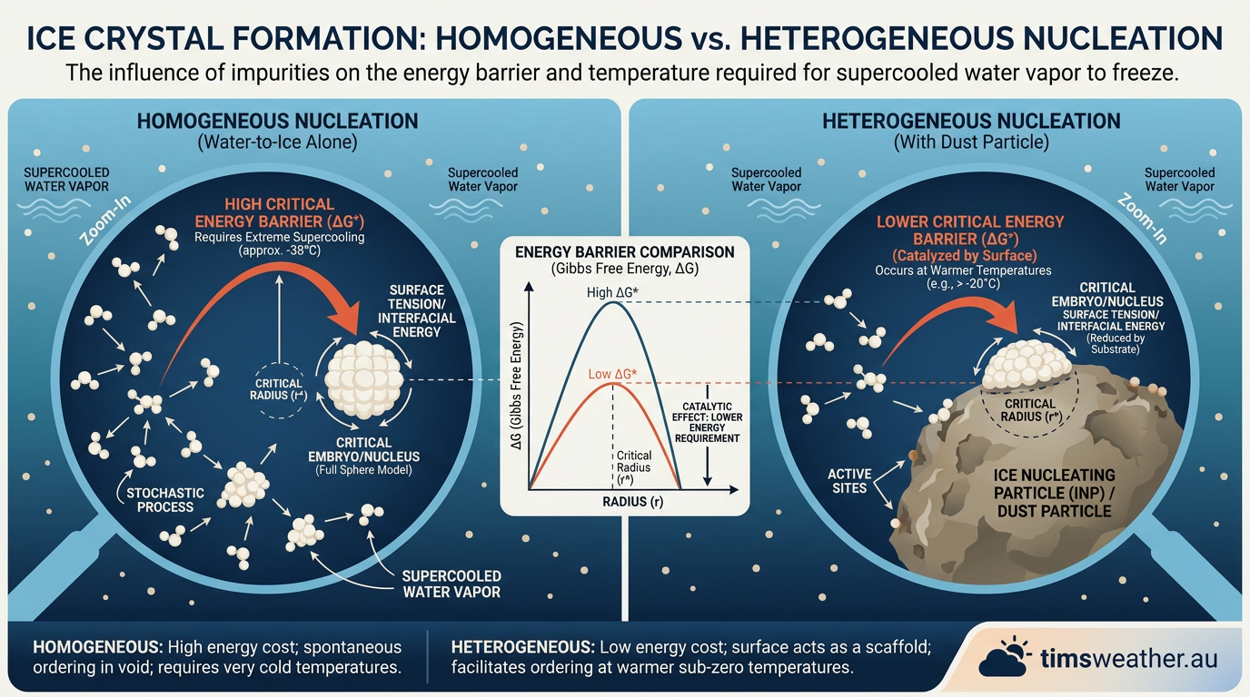
Homogeneous nucleation and heterogeneous nucleation
There are two main routes for ice crystal formation. Heterogeneous nucleation is more common, because ice starts on dust, soot, or mineral particles. Homogeneous nucleation happens without a seed particle, but it needs much colder conditions and very high supersaturation.
Supercooled water droplets can also matter in cloud tops and storm anvils. When they freeze, they add more ice particles to the cloud, which can change how dense the cirrus becomes. In Australian weather work, the Bureau of Meteorology often examines these upper-level ice clouds alongside satellite imagery and sounding data.
What drives cirrus cloud development
Physics makes the ice, but weather systems shape the cloud into bands, sheets, and streaks. The two biggest drivers are the jet stream and convective outflow from thunderstorms.
Jet stream winds and high-altitude clouds
The jet stream is a fast river of air near the tropopause. When it moves moisture and ice crystals through the upper troposphere, it stretches cirrus into long, thin lines. That is one reason these high-altitude clouds often look feathery from the ground.
Strong upper-level winds can also separate the crystals and spread them over a wider area. This makes cirrus easier to spot on satellite images and can blur the edge of nearby cloud bands.
Convective outflow from thunderstorms
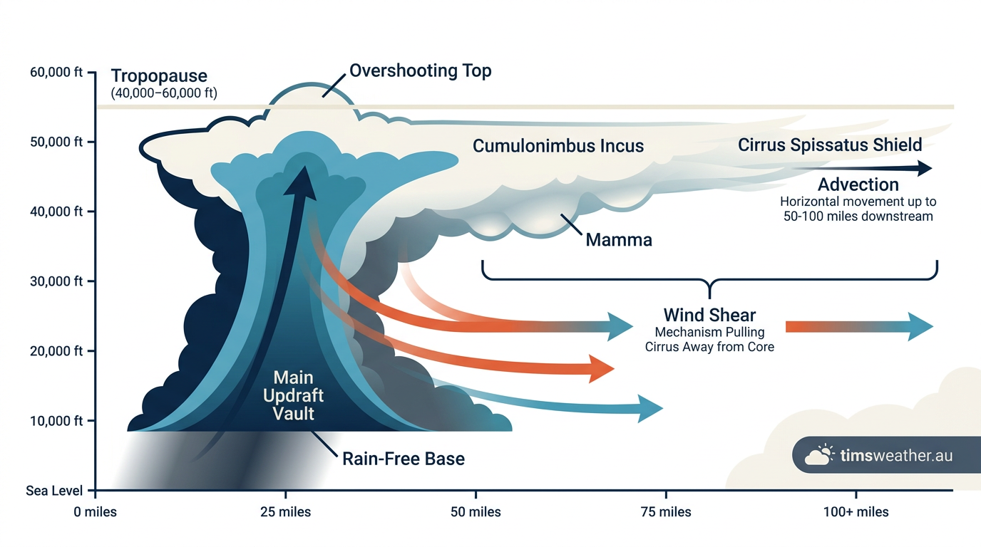
Thunderstorms can push moist air high into the atmosphere, then spread that air outward as an anvil top. As the storm weakens, the leftover ice cloud can drift away as cirrus spissatus or thinner cirrus bands. This is one form of convective outflow.
The source article deep thunderstorm cores explains how strong updraughts build those anvils in the first place. Once the storm top detaches, the ice cloud can keep moving downwind for hours.
Tropical cyclone outflow and Australian cirrus
Tropical cyclones can also feed high cloud through strong outflow aloft. In northern Australia, that outflow can spread ice crystals far from the storm centre and add to cirrus development. For readers in the tropics, this often shows up first as a bright, high shield rather than rain at the surface.
One useful way to think about this is the title Impact of Tropical Cyclone Outflow on Cirrus Development: the outflow spreads upper-level moisture and ice over a broad area, which helps build high-cloud layers. Desert dust can also act as a source of particles, which fits the idea behind The Role of Deserts in Australian Cirrus Formation.
Why cirrus matters for temperature and light
Cirrus clouds matter because they affect radiative forcing. Thin cirrus let much of the Sun’s short-wave energy pass through, but they can trap some outgoing heat from the surface. Thick cirrus can reduce sunlight more strongly and change the day’s brightness.
That is why forecasters pay attention to cirrus cover, not just rain-bearing cloud. A high, thin veil may look harmless, but it still tells you about moisture and wind structure aloft.
How to spot cirrus in Australian skies
In Australia, cirrus often appear ahead of a trough, near the edge of a jet stream, or after thunderstorms have topped out and spread ice high into the air. They usually look white, fibrous, and very high compared with lower cloud types.
- Look for thin streaks or hooks high in the sky.
- Check for a milky veil around the Sun or Moon.
- Watch for spreading anvil tops after storms.
- Use BOM cloud charts and satellite loops when you want the bigger picture.
Related guides
Frequently asked questions
Cirrus clouds form in the upper troposphere when water vapour undergoes deposition, turning directly into ice crystals without becoming liquid first. This occurs in extremely cold, moist air aloft. They can also originate from the tops of thunderstorms, where ice crystals are blown out from anvil clouds into thin streaks.
Source: theweather.com
Further reading and resources
Explore trusted articles, books, videos and other resources to go deeper on this topic.
eos.orgArticle
How Kicked-Up Dust Forms Cirrus Clouds - Eos.org
In-depth coverage on How Do Cirrus Clouds Form? Ice Crystal Science Explained from eos.org.
scied.ucar.eduReference
Cirrus Clouds - UCAR Center for Science Education
Background reference on How Do Cirrus Clouds Form? Ice Crystal Science Explained from scied.ucar.edu.
espo.nasa.govReference
Clarifying the Dominant Sources and Mechanisms of Cirrus Cloud ...
Background reference on How Do Cirrus Clouds Form? Ice Crystal Science Explained from espo.nasa.gov.
en.wikipedia.orgReference
Cirrus cloud
Background reference on How Do Cirrus Clouds Form? Ice Crystal Science Explained from en.wikipedia.org.
study.comArticle
Cirrus Clouds Description, Facts & Types - Video
In-depth coverage on How Do Cirrus Clouds Form? Ice Crystal Science Explained from study.com.
cires.colorado.eduReference
The origins of cirrus: Earth's highest clouds have dusty core | CIRES
Background reference on How Do Cirrus Clouds Form? Ice Crystal Science Explained from cires.colorado.edu.
Cirrus Clouds Description, Facts & Types - Lesson
In-depth coverage on How Do Cirrus Clouds Form? Ice Crystal Science Explained from study.com.
acp.copernicus.orgArticle
Exploring sources of ice crystals in cirrus clouds - Copernicus ACP
In-depth coverage on How Do Cirrus Clouds Form? Ice Crystal Science Explained from acp.copernicus.org.
csl.noaa.govReference
2013 News & Events: The origins of cirrus: Earth's highest clouds have ...
Background reference on How Do Cirrus Clouds Form? Ice Crystal Science Explained from csl.noaa.gov.
whatsthiscloud.comArticle
Cirrus Clouds: High, Wispy Streaks
In-depth coverage on How Do Cirrus Clouds Form? Ice Crystal Science Explained from whatsthiscloud.com.
Planning weeks ahead?
Check Australia's long-range seasonal outlook for rainfall, temperature and the climate drivers (ENSO, IOD, SAM, MJO) shaping the next three months.
View Australia's Seasonal Weather Forecast