
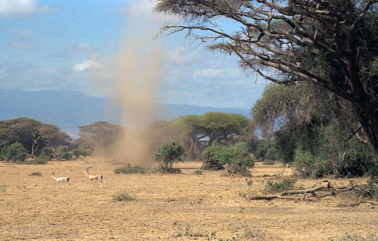
How do dust devils form? The process begins with intense solar radiation heating the ground on calm, clear days. This rapid surface heating warms the lowest layer of the atmosphere, causing a localized thermal updraft to rise quickly through cooler air. As surface friction and wind shear interact with this updraft, the rising air begins to spin, creating a visible vortex.
Key takeaways
Dust devils are surface-driven vortexes triggered by intense solar heating over dry terrain.
Unlike tornadoes, they form from the ground up under clear skies without the need for a thunderstorm.
Most whirlwinds last only a few minutes and dissipate rapidly when cooler air disrupts their heat supply.
They operate in cyclostrophic balance, meaning their rotation direction is driven by local friction rather than the Coriolis effect.
These phenomena are extensively studied on Mars, where massive dust devils routinely alter the planetary atmosphere.
The thermodynamics behind how do dust devils form
The entire process of dust devil formation relies on localized atmospheric instability driven by extreme temperature differences near the ground. During the middle of the day, intense solar radiation strikes the earth. Because dry soil has a low specific heat capacity, it absorbs this energy and rapidly increases in temperature.
The ground then warms a very thin layer of air immediately above it through a process known as sensible heat flux. This creates a steep temperature gradient within the lowest few metres of the atmosphere.
National Oceanic and Atmospheric Administration boundary layer research demonstrates that when this surface air becomes significantly hotter than the air just above it, the Planetary Boundary Layer becomes highly unstable. Hot air is less dense and naturally buoyant, so it seeks to rise.
Instead of rising in a broad, uniform sheet, the hot air tends to break through the cooler overlying air in narrow, focused columns called thermal updrafts. How this extreme surface heating is similar to understanding how do heatwaves form, but concentrated into a microscale environment over a few square metres.
As the thermal updraft accelerates upward, it creates a very small, localized zone of low pressure at the surface. Cooler air from the surrounding area rushes inward to fill this void. If the incoming air converges evenly, you only get a thermal plume. However, if there is a slight disruption in the wind flow, the system begins to acquire angular momentum, setting the stage for a visible whirlwind.
How do dust devils form?
How do dust devils form is best explained by intense surface heating causing a pocket of hot air to rise rapidly through cooler air above it. As this thermal updraft creates a localized low-pressure zone, surface friction induces rotation, concentrating the vortex into a visible whirlwind that draws in loose surface debris.
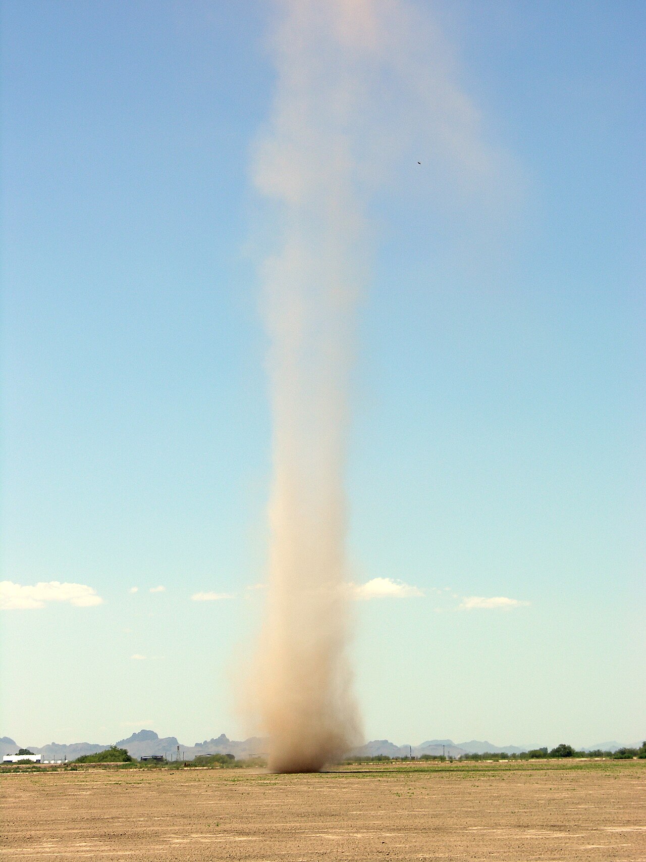
Conditions for dust devil formation: A delicate balance
What causes a dust devil goes beyond simple heat. The phenomenon requires a specific alignment of environmental variables. First, the sky must be clear to allow maximum solar heating. Second, the background wind speed must be very light. If ambient winds are too strong, they mix the boundary layer, dispersing the pocket of superheated surface air before a concentrated thermal updraft can establish itself.
These whirlwinds are heavily dependent on surface conditions. They are most frequently observed around midday when solar radiation peaks, creating the ideal temperature disparities noted by WRAL. A desert climate provides the perfect breeding ground due to the dry, barren soil that heats up rapidly. Consequently, they are a daily occurrence in arid environments like the Southwest United States, as highlighted in reports by KXAN.
Despite their preference for deserts, they can form in unexpected locations if the thermodynamic criteria are met. Any flat surface that heats unevenly can trigger the necessary updraft.
A rare event captured on a local weather report demonstrated a dust devil spinning up on a flat, dry ball field in Warwick, Rhode Island. Small variations in surface albedo, such as the transition from dry dirt to a paved road, can create the slight horizontal temperature differences needed to kickstart the updraft, similar to the initial stages of how do low-pressure systems form but on a drastically smaller scale.
The mechanics of rotation: From updraft to whirlwind
Once the localized thermal updraft is established, it needs a source of rotation. At the microscale of a dust devil, rotation is almost entirely dictated by surface friction, topography, or subtle horizontal wind shear.
As the air rushes inward toward the low-pressure centre, any slight asymmetry in the surrounding terrain causes the air to enter the updraft at an angle. As the column stretches vertically, it narrows. Due to the conservation of angular momentum, the narrowing column spins faster, tightening into a high-speed vortex.
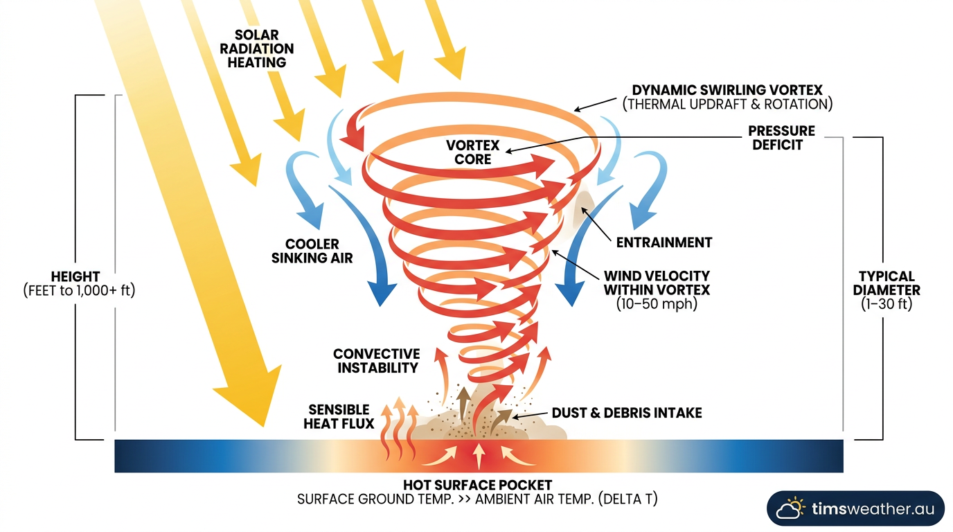
This process highlights a fascinating meteorological concept known as cyclostrophic balance. In massive weather systems like hurricanes, the Coriolis effect determines the direction of rotation. However, for a dust devil, the diameter is so small and the lifespan so short that the Coriolis effect has absolutely zero influence.
Instead, the vortex achieves cyclostrophic balance, a state where the inward-directed pressure gradient force is perfectly countered by the outward-directed centrifugal force of the spinning air. Because Coriolis is negligible, they can rotate clockwise or counterclockwise with nearly equal probability in either hemisphere.
The vortex itself remains completely invisible until it interacts with loose material. The spinning wind creates a suction effect at the surface, lofting fine dirt, sand, and lightweight debris into the air. According to WTVO, it is this suspended particulate matter that makes the structure of the whirlwind visible to observers. Once the dust is lifted, the classic funnel shape appears, clearly defining the walls of the rotating column.
Dust devil vs tornado difference: Critical distinctions
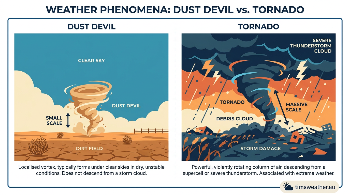
A common question is whether these whirlwinds are just miniature tornadoes. Meteorologically, a dust devil is fundamentally different from a tornado. The primary distinction lies in their genesis and atmospheric environment. Tornadoes are a product of deep, severe convective activity.
They require a severe thunderstorm, specifically a supercell with a rotating updraft known as a mesocyclone, to descend from the cloud base to the ground. This process of supercell tornado formation relies on intense vertical wind shear and massive amounts of atmospheric moisture.
In stark contrast, dust devils are bottom-up phenomena. They form from the ground up on clear, calm days completely devoid of thunderstorm activity. They have no connection to a cloud base and are driven purely by sensible heat flux at the surface rather than latent heat release within a storm.
Even weaker tornadic phenomena, such as landspouts, are distinct. As detailed by MPR News, landspouts may form from the ground up like a dust devil, but they strictly develop beneath the towering cumulus clouds of a developing thunderstorm, maintaining a direct connection to the cloud layer above.
Feature | Dust Devil | Tornado |
|---|---|---|
Formation Mechanism | Bottom-up thermal updraft from surface heating | Top-down descent from a thunderstorm mesocyclone |
Weather Conditions | Clear, sunny skies with light background winds | Severe thunderstorms, high moisture, strong shear |
Lifespan | Typically 1 to 5 minutes | Often 10 minutes to over an hour |
Wind Speeds | Usually under 100 km/h | Frequently 150 km/h to over 300 km/h |
Are dust devils dangerous? Wind, lifespan and safety
While their twisting appearance can be alarming, dust devils are generally a harmless meteorological phenomenon. The vast majority possess wind speeds below 60 km/h, which is barely enough to rustle tree branches or lift dry leaves.
However, it is entirely possible for a particularly intense vortex to reach wind gusts approaching 100 km/h. In these rare instances, do dust devils have wind strong enough to cause damage? Yes, they can occasionally tear shingles from roofs, collapse weak outdoor gazebos, or throw loose debris at hazardous speeds.
How long do dust devils last is closely tied to their heat source. Because they rely entirely on the pocket of superheated air at the surface, their existence is highly fragile. As explained by meteorologist AJ Rickman on KCRG-TV9, they are temporary structures that dissipate almost instantly when cooler, denser air intrudes into the circulation.
As the vortex moves across the sector, it inevitably travels over a cooler patch of ground or sucks in cool air, which chokes off the thermal updraft and causes the whirlwind to collapse rapidly.
If you find yourself in the path of one, surviving a dust devil is straightforward. The primary hazard is not the wind itself, but the particulate matter suspended in it. Turning away from the vortex, closing your eyes, and covering your mouth and nose will protect your airways from the dirt. Once the column passes, the air quickly clears, unlike the lingering atmospheric haze associated with how do sandstorms form across broader regions.
Extraterrestrial whirlwinds: Dust devils on Mars
One of the most fascinating aspects of convective instability is that it is not unique to Earth. The principles of thermodynamics apply universally, making dust devils a highly common feature on Mars. Data collected by NASA orbiters and the Mars Exploration Rover missions reveal that these extraterrestrial whirlwinds are far larger than their earthly counterparts. On Mars, dust devils can reach heights of up to 1 kilometre and have been observed spanning tens of metres across, not hundreds of metres or 8 kilometres.
The Martian atmosphere is incredibly thin, with an average surface pressure of roughly 6 hPa compared to Earth's 1013 hPa. Despite this low density, the temperature gradient between the sun-baked Martian regolith and the freezing air immediately above it is extreme enough to generate massive sensible heat flux.
These giant vortexes are major drivers of the Martian climate. They are responsible for lofting massive amounts of fine red dust into the upper atmosphere, altering the planet's albedo and influencing global temperature patterns. Practically, they have also served as unexpected wind-cleaners, routinely sweeping accumulated dust off the solar panels of robotic landers and extending their operational lifespans.
A meteorologist's view: Forecasting microscale convective activity
Predicting exactly where and when a dust devil will occur is impossible. They are microscale convective events, meaning their physical size and lifespan fall far below the grid resolution of modern numerical weather prediction models. Forecasters cannot issue a warning for a specific paddock or street corner. However, meteorologists can easily identify the broad synoptic conditions favourable for their development.
According to the International Cloud Atlas published by the World Meteorological Organization, these whirlwinds are officially classified as lithometeors. When forecasters see a combination of high pressure, deep dry air, and intense solar radiation, they know the boundary layer will experience extreme sensible heat flux. Local news outlets, such as We Are Iowa, often report an increase in public sightings during unseasonably dry, hot spells when soil moisture is completely depleted.
Meteorologists differentiate these dry-air thermals from the moist-air updrafts that drive thunderstorms. A true thunderstorm requires significant low-level moisture so that rising air reaches its dew point, condenses, and releases latent heat to fuel how do single-cell thunderstorms form. Dust devils occur entirely below the lifting condensation level.
There is no moisture to condense, no latent heat release, and no cloud formation. They are the atmosphere's rawest demonstration of heat seeking equilibrium, turning stagnant surface heat into visible, spinning kinetic energy before vanishing back into the clear sky. You will never see one produce precipitation, and you will certainly never need to understand how does thunder form to explain the clear, quiet weather surrounding them.
Sources
NASA rover captures sound of Martian dust devil for first time (abc.net.au)
NOAA weather and atmospheric science reference (repository.library.noaa.gov)
Dust whirl or sand whirl (dust devil) (cloudatlas.wmo.int)
NOAA weather and atmospheric science reference (gfdl.noaa.gov)
Mars | COSMOS (astronomy.swin.edu.au)
NOAA weather and atmospheric science reference (gfdl.noaa.gov)
physics.usyd.edu.au PDF reference (physics.usyd.edu.au)
Mars | COSMOS (astronomy.swin.edu.au)
Last verified: 2026-09-13
Frequently asked questions
Dust devils form when the sun heats the ground unevenly on clear, calm days. This intense surface heat creates a pocket of hot, rising air near the ground. As this air ascends quickly through cooler air above, small surface disturbances cause it to rotate, creating a visible, spinning column of dust.
Source: bom.gov.au
Further reading and resources
Explore trusted articles, books, videos and other resources to go deeper on this topic.
windy.appArticle
What is a dust devil - Windy.app
In-depth coverage on How Do Dust Devils Form? The Meteorological Guide to Whirlwinds from windy.app.
farmprogress.comArticle
How to tell a dust devil from a tornado - Farm Progress
In-depth coverage on How Do Dust Devils Form? The Meteorological Guide to Whirlwinds from farmprogress.com.
youtube.comVideo
Weather Explainer: How do dust devils form? - YouTube
Video coverage on How Do Dust Devils Form? The Meteorological Guide to Whirlwinds from youtube.com.
weather.govReference
Dust Devils - National Weather Service
Background reference on How Do Dust Devils Form? The Meteorological Guide to Whirlwinds from weather.gov.
wral.comArticle
Ask the Meteorologist: How do dust devils form? - WRAL
In-depth coverage on How Do Dust Devils Form? The Meteorological Guide to Whirlwinds from wral.com.
weather.metoffice.gov.ukReference
Willy willy, also known as a 'dust devil' - Met Office
Background reference on How Do Dust Devils Form? The Meteorological Guide to Whirlwinds from weather.metoffice.gov.uk.
utahweather.orgArticle
Whirlwinds or Dust Devils · UCCW - Utah Center for Climate and Weather
In-depth coverage on How Do Dust Devils Form? The Meteorological Guide to Whirlwinds from utahweather.org.
en.wikipedia.orgReference
Dust devil - Wikipedia
Background reference on How Do Dust Devils Form? The Meteorological Guide to Whirlwinds from en.wikipedia.org.
Planning weeks ahead?
Check Australia's long-range seasonal outlook for rainfall, temperature and the climate drivers (ENSO, IOD, SAM, MJO) shaping the next three months.
View Australia's Seasonal Weather Forecast