
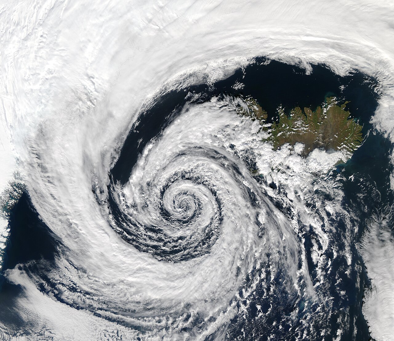
How do low-pressure systems form? They develop when air converges near the surface, rises, and lowers surface pressure beneath it. As that air climbs, it cools, condenses and often forms cloud and rain. Rotation then depends on Earth’s spin and the balance between the pressure gradient force and the Coriolis effect.
Key takeaways
Low-pressure systems start with surface convergence, rising air and a drop in barometric pressure.
The Coriolis effect bends moving air, so lows spin counter-clockwise in the Northern Hemisphere and clockwise in the Southern Hemisphere.
Thermal convection can help trigger a low when strong surface heating makes air buoyant.
Rossby waves and jet stream interaction often help create and deepen mid-latitude lows through upper-level troughs and divergence aloft.
Latent heat release can strengthen a low after cloud and rain begin to form.
Synoptic-scale meteorology, hydrostatic balance and the pressure gradient force help explain why isobars tighten around active lows.
How do low-pressure systems form in synoptic-scale meteorology?
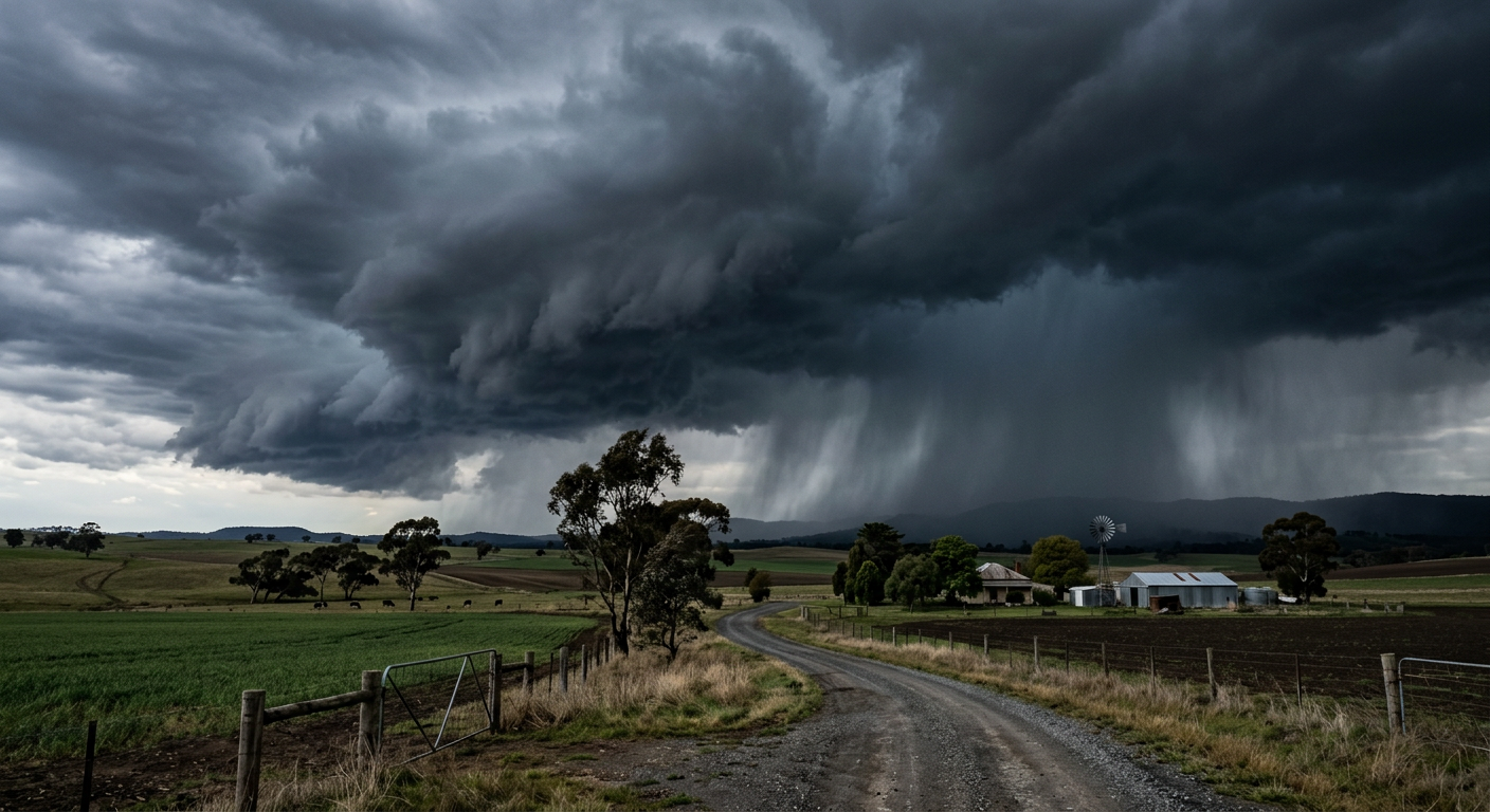
A severe low-pressure system generating dark storm clouds and heavy precipitation over an open field.
What physical processes start cyclogenesis?
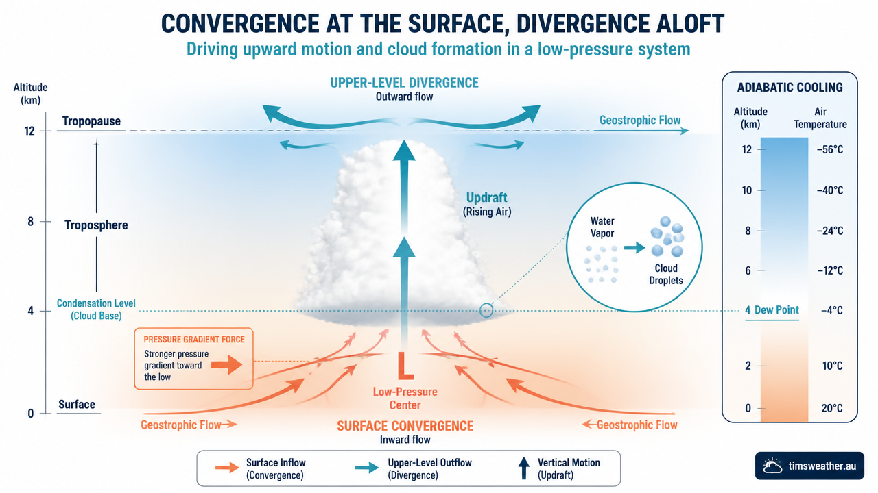
Infographic showing how do low-pressure systems form through surface convergence and upper-level divergence.
Cyclogenesis is the formation or strengthening of a low-pressure system. It begins when the atmosphere creates lift faster than it can restore balance. That lift can come from thermal convection, a front, terrain, or strong divergence aloft. Once the surface pressure falls enough, nearby air moves in, rises, and the circulation becomes organised.
Thermal convection is one of the simplest triggers. Warm ground heats the air above it, the air becomes less dense, and it rises. If the rising motion is deep enough, the pressure falls at the surface and a weak low can form or intensify. You can see a related process in How do cumulus clouds form? Convection, condensation and cloud base height.
Mid-latitude lows often need extra help from the upper atmosphere. Rossby waves, which are large meanders in the mid-latitude flow, can carve out an upper-level trough. When that trough lines up with jet stream interaction, it can promote divergence aloft. Air is then pulled away from the top of the column, which lowers the pressure below and helps the surface low deepen. This is one of the core reasons a small wave on a front can grow into a full depression or storm.
For a focused explanation of that upper-air lift, see How Do Warm Fronts Form? The Complete Meteorological Guide and How Do Cold Fronts Form? The Complete Meteorological Guide. Fronts often sharpen the temperature contrast that helps a low organise.
The role of upper-level divergence in strengthening surface lows
Upper-level divergence removes air from the top of the column faster than it can be replaced from below. The result is a lowering of surface pressure and stronger upward motion through the column. This process is one reason a low can intensify even when the surface pattern looks weak at first. The air below rises to compensate, cloud thickens and rainfall can increase.
There is a simple way to think about it. If you empty the top of an air column, the column below has less weight pressing down. The surface pressure drops, and the system tightens. That is why forecasters watch the alignment between the jet stream, troughs and surface lows so closely. For more on that upper-air link, see How Do Thunderstorms Form? An Explainer on Australian Storm Development, which covers how lift and instability can organise into stronger weather.
Latent heat release also matters. When water vapour condenses into cloud droplets, it releases heat into the air around it. That added heat makes the rising air parcel a little warmer than its surroundings, so it can keep rising. This does not create a low on its own, but it can help a system strengthen once clouds and rain are established. That feedback is part of what makes mature lows so efficient at producing weather.
Why do low-pressure systems spin differently in the Northern and Southern Hemispheres?
The answer is the Coriolis effect. As air moves toward low pressure, Earth’s rotation deflects that flow. In the Northern Hemisphere, air curves to the right, so winds spiral counter-clockwise into the low. In the Southern Hemisphere, the deflection is to the left, so winds spiral clockwise. The system is the same, but the spin changes with hemisphere.
This is not because the low “chooses” a direction. It is the result of moving air crossing a rotating planet. A small, weak low may have an uneven, loose circulation. A larger, deeper system with tighter isobars shows the pattern more clearly. That is why meteorologists treat rotation, pressure gradient and scale together rather than as separate ideas.
The same physics underpins many storm types. A tropical depression, an extratropical low and a cut-off low all depend on pressure differences, but each uses a different fuel source and sits in a different circulation regime. For a linked explanation of how a broad low starts to rotate, see How Do Tropical Depressions Form? The Complete Meteorological Guide and How Do Tropical Cyclones Form?.
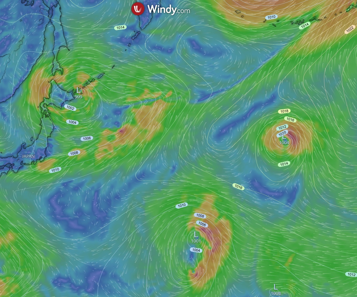
Observe multiple swirling low-pressure systems and isobar lines over Japan, illustrating how these weather phenomena form and impact conditions. Courtesy of www.windy.com
Why low-pressure systems spin differently in the Northern and Southern Hemispheres
Once wind begins to move, the Coriolis effect deflects it. The turning is weaker near the equator and stronger toward the poles, which is why organised rotation is harder to build close to 0°. That is also why forecasters pay attention to latitude when judging whether a weak disturbance can develop into a true low.
Another way to picture it is through moving air and pressure gradients together. The gradient tries to pull air straight toward the low. The Coriolis effect bends that motion sideways. The result is a spiral, not a direct rush inward. The balance between those two effects is central to how pressure systems look on weather maps and satellite loops.
How do fronts, the jet stream and Rossby waves help low-pressure systems form?
Many mid-latitude lows begin where air masses clash along a front. Warm air sits beside colder, denser air, and the contrast creates a zone of baroclinic instability. If upper-level support arrives at the same time, the wave on the front can deepen. This is where Rossby waves and jet stream interaction become important, because they help set up the upper-level trough that favours rising air below.
Rossby waves are large-scale bends in the westerly flow. As one trough moves through, it can pull colder air southward on its western side and warm air northward on its eastern side. That pattern helps sharpen gradients and can make the atmosphere more likely to spin up a low. The low is then fed by convergence near the surface and divergence aloft, which is a classic cyclogenesis setup.
Not every front turns into a deep low. The atmosphere needs the right timing, enough moisture, and a strong enough jet streak or upper trough. If those pieces line up, the system can intensify quickly. If they do not, the wave may pass with only cloud and a brief patch of rain.
For readers who want to see the cloud side of the process, How do cumulonimbus clouds form? Stages, triggers and severe weather impacts explains how strong lift and instability can build tall storm clouds. Low pressure and thunderstorm development often share the same basic ingredients, even though the final weather can look very different.
From Heat to Rotation: The Thermodynamics of Cyclogenesis
Thermodynamics gives the system its fuel. Surface heating, moisture supply and condensation all shape how much energy is available for rising air. Once condensation begins, latent heat release helps the air keep climbing. That rising motion draws in more air at the surface, which can lower pressure further. In other words, heat helps start the process, and the changing pressure field helps sustain it.
This is why the phrase “from heat to rotation” makes sense in meteorology. Heat does not directly create spin. It changes density, encourages ascent and deepens the pressure fall. Rotation follows because the air is moving on a rotating planet. Seen together, those steps explain most cyclogenesis pathways.
For a related upper-air discussion, see How do mesoscale convective systems form? Large clusters of storms can also feed on organised lift and latent heat release, although they operate on a smaller scale than a classic synoptic low.
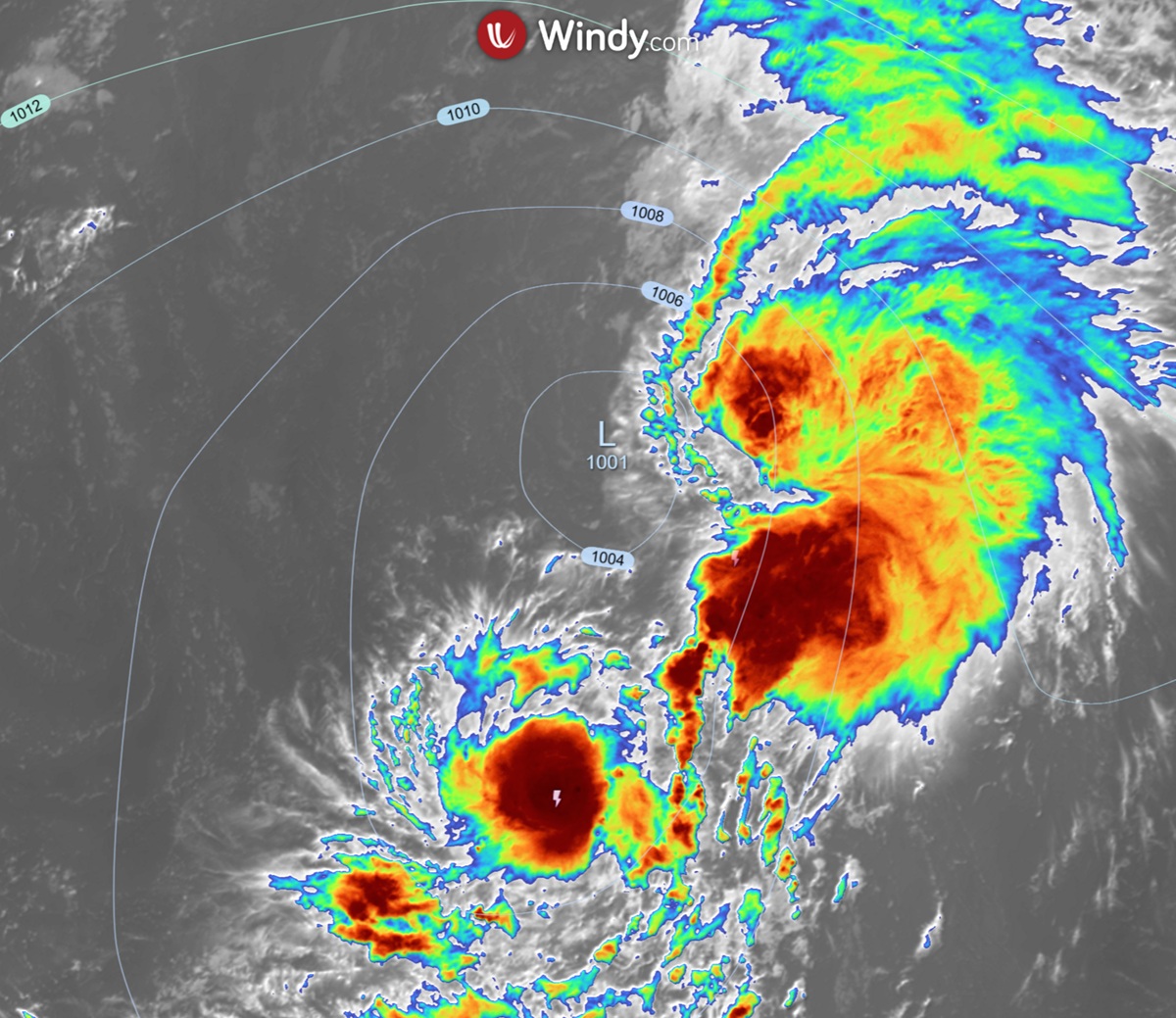
Satellite view of a powerful low-pressure system with isobar lines, illustrating the core elements discussed in our meteorological guide on their formation. You can see convection (thunderstorms) developing around the low pressure system. Courtesy of www.windy.com
What do meteorologists watch on weather maps?
Forecasters track a low by reading the pressure field, the wind field and the vertical structure above it. On a synoptic chart, a deepening low usually shows tighter isobars, a sharper pressure gradient and a stronger circulation around the centre. Satellite and radar then show whether cloud bands and rainfall are organising around the core.
The main signs are straightforward:
falling central pressure
tightening isobars around the centre
increasing wind speeds as the gradient strengthens
cloud bands wrapping toward the low
rainfall expanding near fronts or the low centre
One useful concept is convergence and divergence. Convergence at the surface forces air up. Divergence aloft removes air from the top of the column. Put together, they help maintain the low. If the upper-level support weakens, the system often fills, the pressure rises and the winds ease.
On some charts, especially those used by the Bureau of Meteorology, the tightest pressure packing can be read alongside fronts and troughs to judge where the strongest weather is likely. For a chart-reading guide, see High and Low Pressure Systems Australia Explained. For the cloud forms that often sit around active lows, Nimbostratus Cloud Formation: How They Form, Look and Rain is also useful.
How do low-pressure systems affect weather at the surface?
Low-pressure systems often bring cloudier, wetter and windier conditions because air is rising and cooling. As the air cools, water vapour condenses, which builds cloud and rain. If the low is strong enough, the pressure gradient force can also drive gusty winds, especially near fronts or the centre of the system.
The exact surface impact depends on the system type. A shallow coastal low may produce a day of rain and brisk winds. A deeper mid-latitude low can bring a wider rain band, squally winds and falling temperatures behind the front. A tropical system behaves differently again because warm ocean water and deep moisture feed the circulation from below.
That is why the same basic low-pressure physics can produce very different weather. The driver is always the same, a pressure fall and rising air, but the environment decides whether the result is light drizzle, widespread rain or severe storms. If you are checking a forecast, focus on the pressure trend, wind shift and rainfall totals, not just the label of the system.
How do low-pressure systems form in different settings?
Low-pressure systems can form over land or sea, in the tropics or in the mid-latitudes. The trigger changes, but the core process stays the same. Air rises, pressure falls, and the system draws in more air near the surface. What differs is the source of lift and the way the system gets extra energy.
Here is a simple comparison:
Setting | Main trigger | Common result |
|---|---|---|
Warm land surface | Thermal convection | Shallow low, showers, afternoon storms |
Front between air masses | Frontal lift and upper-level divergence | Widespread rain band, stronger winds |
Mid-latitudes | Rossby waves and jet stream interaction | Deepening extratropical low |
Tropics | Moist convection and latent heat release | Tropical depression or cyclone |
In the tropics, you can compare that process with How Do Tropical Cyclones Form? The Complete Meteorological Guide. In the mid-latitudes, the same lift-and-divergence pattern often produces rain-bearing lows rather than tropical systems. The atmospheric engine is shared, but the details are different.
Frequently asked questions
Low-pressure systems form when air near the surface warms and rises, reducing the weight of the air above and lowering atmospheric pressure. This process is often enhanced by air converging at the surface and diverging in the upper atmosphere, which helps pull more air upwards to deepen the system.
Source: bom.gov.au
Further reading and resources
Explore trusted articles, books, videos and other resources to go deeper on this topic.
kestrelinstruments.comArticle
What Is a Low-Pressure System and How Can You ...
In-depth coverage on How Do Low-Pressure Systems Form? The Complete Meteorological Guide from kestrelinstruments.com.
pilotinstitute.comArticle
High vs. Low-Pressure Systems Explained
In-depth coverage on How Do Low-Pressure Systems Form? The Complete Meteorological Guide from pilotinstitute.com.
weather.govReference
Basic Discussion on Pressure
Background reference on How Do Low-Pressure Systems Form? The Complete Meteorological Guide from weather.gov.
en.wikipedia.orgReference
Low-pressure area
Background reference on How Do Low-Pressure Systems Form? The Complete Meteorological Guide from en.wikipedia.org.
nesdis.noaa.govReference
What Are High and Low Pressure Systems? | NESDIS - NOAA
Background reference on How Do Low-Pressure Systems Form? The Complete Meteorological Guide from nesdis.noaa.gov.
surfertoday.comArticle
What causes a low-pressure system to form?
In-depth coverage on How Do Low-Pressure Systems Form? The Complete Meteorological Guide from surfertoday.com.
How to Read a Weather Map | NESDIS
Background reference on How Do Low-Pressure Systems Form? The Complete Meteorological Guide from nesdis.noaa.gov.
aopa.orgArticle
Pressure Systems
In-depth coverage on How Do Low-Pressure Systems Form? The Complete Meteorological Guide from aopa.org.
wificfi.comArticle
Wind Circulation Around Highs and Lows: A Pilot's Guide ...
In-depth coverage on How Do Low-Pressure Systems Form? The Complete Meteorological Guide from wificfi.com.
scied.ucar.eduReference
The Highs and Lows of Air Pressure
Background reference on How Do Low-Pressure Systems Form? The Complete Meteorological Guide from scied.ucar.edu.
Planning weeks ahead?
Check Australia's long-range seasonal outlook for rainfall, temperature and the climate drivers (ENSO, IOD, SAM, MJO) shaping the next three months.
View Australia's Seasonal Weather Forecast