
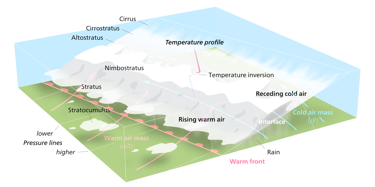
How do warm fronts form? It comes down to air mass displacement where a warm, less dense air mass advances toward a cooler, denser air mass. Because the warm air is lighter, it rises over the cold air in a process called overrunning, causing the air to cool, condense, and form persistent stratiform clouds.
Key takeaways
- Warm fronts develop when a lighter warm air mass glides over a retreating, dense cold air mass along a shallow boundary.
- This gentle atmospheric lifting produces expansive layers of stratus and nimbostratus clouds ahead of the surface front.
- Steady, prolonged precipitation and a gradual drop in atmospheric pressure typically accompany their passage.
- Meteorological charts depict these frontal boundaries as solid red lines with semicircles pointing toward the cooler air.
- They are primary drivers of synoptic scale weather in mid-latitude cyclones, driven by strong temperature gradients.
The physics of overrunning: how do warm fronts form
To understand the mechanics of weather boundaries, you must first look at the fundamental thermodynamics of differing air masses. When a warm air mass moves into a territory occupied by a cold air mass, the resulting interaction is entirely defined by their contrasting densities. The temperature of an air parcel directly dictates its physical density. Cold air features tightly packed molecules, making it physically denser, heavier, and prone to settling close to the earth's surface. In contrast, warm air contains more energetic, spread-out molecules, making it significantly lighter and more buoyant.
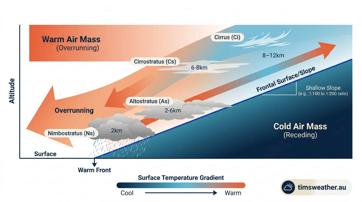
As the warm air pushes forward, it simply lacks the physical weight to dislodge the heavy cold air block out of its way. Instead, the warmer air is forced to ascend and glide up the inclined slope of the cold air mass. This specific mechanical process of warm air displacement is known in meteorology as overrunning. The boundary where these two distinct air masses meet and interact is called a frontal zone. The steep temperature gradient across this zone acts as the primary fuel for the resulting meteorological systems.
According to educational atmospheric science materials published by the Federal Aviation Administration, understanding these air mass characteristics is essential because the advancing warm air carries the specific temperature and humidity profile of its source region, fundamentally altering the weather of the areas it overruns.
How do warm fronts form step-by-step?
The formation follows a predictable physical sequence. First, a stable cold air mass sits over a region, typically rotating around an established high-pressure system. Second, a warm, moist air mass approaches, driven by broader synoptic scale weather patterns and steering winds in the upper troposphere. Third, the warm air meets the cold block and begins gliding up its shallow incline. Fourth, as the warm air gains altitude, it undergoes adiabatic cooling, meaning its temperature drops as atmospheric pressure decreases with height. Finally, the cooling air reaches saturation, causing invisible water vapour to condense into widespread, layered cloud decks long before the surface boundary actually arrives.
Why does warm air rise over cold air in a warm front?
Warm air rises over cold air strictly because of gravity acting on differing air mass densities. When the two air masses collide, gravity keeps the denser, heavier cold air anchored firmly near the surface. This creates a physical barrier shaped like a shallow wedge. The lighter, more buoyant warm air has no structural choice but to ascend the resulting inclined plane, resulting in steady, gentle atmospheric lifting.
Structural characteristics and atmospheric lifting
The structural reality of a frontal boundary is best visualised by looking at meteorology-standard vertical cross-sections. Unlike a vertical wall, this front is a highly tilted, extremely shallow incline. The slope of the cold air wedge beneath the overriding warm air is usually between 1:100 and 1:200. This ratio means that for every 100 to 200 kilometres you travel horizontally ahead of the surface front, the boundary between the warm and cold air rises by barely one kilometre in altitude.
This shallow slope is a core feature highlighted in meteorology training guides published by Clear ATPL, which explain that this 1:150 average incline directly causes the broad sequences of layered clouds. Because the ascent is so gradual, the air has ample time to spread out horizontally as it cools, generating expansive decks of stratus-type clouds rather than the tall, vertical towers associated with sudden updrafts.
The historical foundation for understanding these tilted boundaries comes from the Norwegian Cyclone Model. Developed by meteorologists in the early 20th century, this model outlined how baroclinic instability along a polar front generates a mid-latitude cyclone. The warm front represents the leading edge of the warm sector, extending poleward and eastward from the central low-pressure area. Broad atmospheric currents, including the jet stream, heavily influence the progression of these boundaries. The Coriolis effect causes the entire cyclone to rotate, pushing the warm air mass forward and sustaining the atmospheric lifting mechanism over vast geographical distances.
What is the difference between a warm front and a cold front formation?
The main difference between a warm front and a cold front formation lies in which air mass acts as the aggressor. A detailed look at how do cold fronts form reveals that dense cold air advances and physically undercuts warmer air like a bulldozer, forcing rapid, vertical lifting along a steep boundary. Conversely, a warm front features lighter warm air climbing gently over a retreating cold air mass, resulting in a much shallower slope, slower atmospheric lifting, and lighter, widespread precipitation.
Warm front progression and precipitation
Because warm air rises slowly over that gentle incline, the associated weather changes unfold gradually over a large geographic area. The atmospheric lifting is inefficient compared to a steep cold front, which translates to a slower forward progression speed across the earth's surface. These boundaries typically travel at 15 to 20 knots, which is often half the speed of many cold fronts.
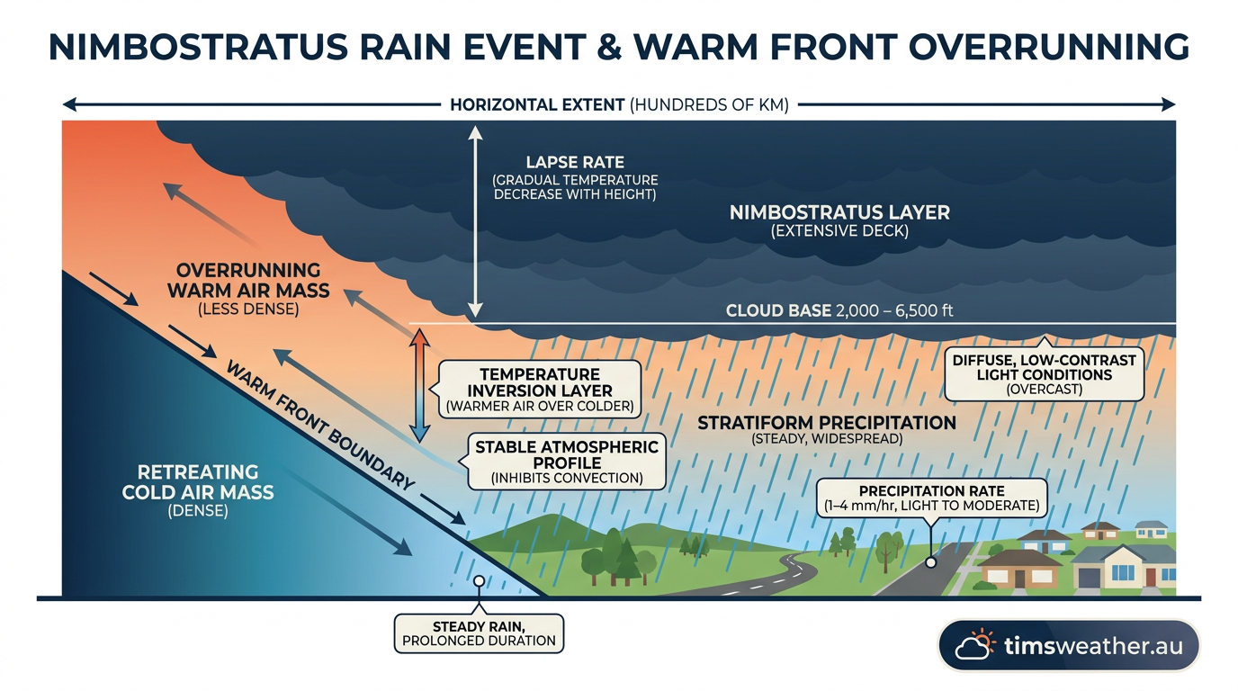
As the precipitation falls through the colder air trapped beneath the frontal boundary, the evaporating moisture can raise the local humidity and lower the dew point gap. When the warm, moist air moves directly over a cold ground surface ahead of the front, advection fog formation frequently occurs, which can severely reduce visibility for days at a time.
As outlined in glossaries provided by Cordulus, the warm, humid air gliding over the colder air mass causes gradual sequences of weather changes, starkly contrasting with the sudden, violent downpours and lightning storms often triggered by cold fronts.
What kind of weather is associated with a warm front?
The weather associated with a warm front is characterised by extensive cloud cover, steady and prolonged precipitation, and a slow drop in atmospheric pressure. Because the warm air ascends gradually, it generates large, stable areas of precipitation rather than isolated, violent thunderstorms. You can expect hours or even days of light to moderate rain, drizzle, or snow. After the surface front passes, winds typically shift direction, precipitation clears, and temperatures rise noticeably.
What clouds are associated with warm fronts?
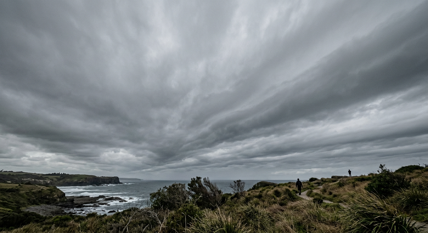
A specific sequence of clouds heralds the approach of the surface front. High-altitude cirrus clouds appear first, hundreds of kilometres ahead of the boundary. These lower into cirrostratus, often creating a halo around the sun. Next, altostratus clouds formation takes over, turning the sky into a mid-level grey sheet. Finally, dark nimbostratus clouds arrive, delivering steady, persistent rain.
The lifecycle of a frontal boundary: from frontogenesis to frontolysis
Meteorologists define the lifecycle of a front through two primary operational terms: frontogenesis and frontolysis. Frontogenesis is the initial formation or intensification of a frontal zone. This process happens when synoptic-scale weather patterns force air masses with significantly different temperatures together, tightening the temperature gradient. The jet stream often provides the upper-level divergence required to lower surface atmospheric pressure, which draws the contrasting air masses tightly against one another and spins up a mid-latitude cyclone.
As the cyclone matures, the warm front rotates around the low-pressure centre. However, because cold fronts move faster, the cold front eventually catches up to the warm front. When this happens, the warm air sector is completely lifted off the surface, creating an occluded front. This process inevitably leads to frontolysis, which is the weakening and dissipation of the frontal boundary. Frontolysis occurs when the temperature gradient washes out, typically because the air masses have thoroughly mixed or the broader atmospheric circulation has lost its kinetic energy.
The thermodynamic profile of these systems is thoroughly documented in university-level resources such as those hosted by LibreTexts, which highlight that surface fronts are essential transition zones governing sensible weather patterns globally.
It is helpful to contrast these mid-latitude systems with tropical phenomena. Unlike mid-latitude cyclones, which rely entirely on baroclinic instability and contrasting air masses, tropical systems form in uniform warm air. Exploring how do tropical cyclones form shows that they extract energy from latent heat release over warm oceans, completely lacking the distinct frontal boundaries that define extratropical weather systems.
Identifying warm front symbols on weather maps
Reading synoptic charts correctly is essential for anticipating broad weather changes, and high and low pressure systems provide the framework for these maps. Meteorologists use specific notation to standardise how weather boundaries are visualised on a global scale. The Bureau of Meteorology defines a warm front as the boundary where warmer air replaces cooler air, noting that these are plotted on charts to highlight regions of broad temperature change.
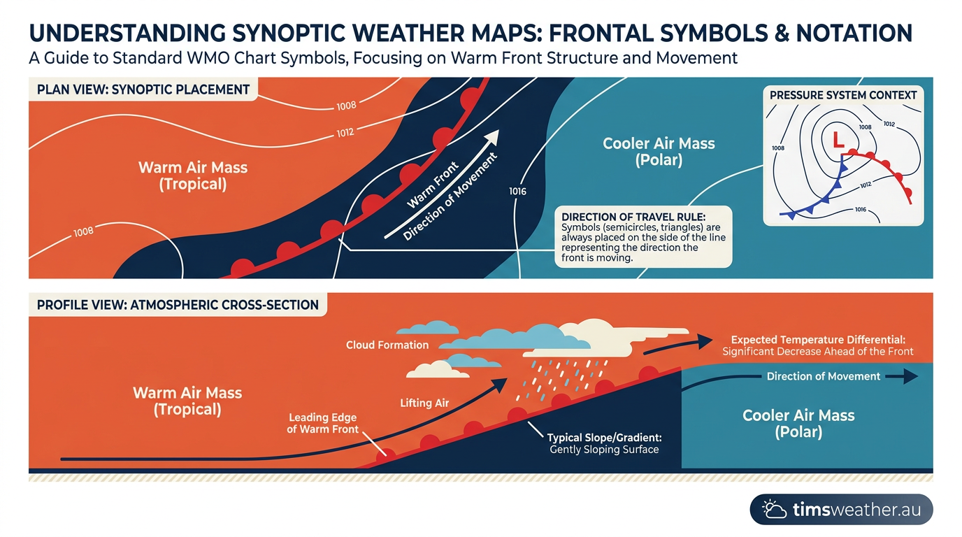
To ensure international consistency, the World Meteorological Organization mandates that warm fronts are depicted on surface analysis charts as solid red lines adorned with solid red semicircles. These semicircles always point in the direction the warm air is moving.
Forecasters from agencies like the National Oceanic and Atmospheric Administration map these fronts by locating the leading edge of the sharpest temperature and dew point gradients. They also look for characteristic wind shifts; winds often blow from the east or southeast ahead of the front and shift to the south or southwest after it passes in the Northern Hemisphere.
In modern forecasting, meteorologists use high-resolution rapid refresh (HRRR) model data to identify the exact position of the frontal boundary, allowing them to issue precise warnings for aviation and public safety. As noted by Epic Flight Academy, tracking these fronts is especially important for pilots, as the extensive layered clouds can hide hazardous embedded thunderstorms and dangerous icing conditions.
| Feature | Warm Front | Cold Front | Stationary Front |
|---|---|---|---|
| Air Mass Movement | Warm air advances | Cold air advances | Neither air mass advances |
| Boundary Slope | Shallow (approx. 1:150) | Steep (approx. 1:50) | Varies, generally shallow |
| Progression Speed | Slow (approx. 15 knots) | Fast (approx. 25-30 knots) | Negligible movement |
| Precipitation | Steady, prolonged rain | Heavy, brief showers | Persistent, light rain |
Frequently asked questions
Warm fronts form when a warmer air mass advances toward a region of cooler air. Because the warm air is less dense, it glides up and over the cold air along a shallow, sloping boundary. This steady ascent causes the air to cool, often creating widespread cloud cover and rain.
Source: bom.gov.au
Further reading and resources
Explore trusted articles, books, videos and other resources to go deeper on this topic.
pilotinstitute.comArticle
Weather Fronts Explained (Cold, Warm, Stationary, Occluded)
In-depth coverage on How Do Warm Fronts Form? The Complete Meteorological Guide from pilotinstitute.com.
youtube.comVideo
The Four Types of Fronts Explained - YouTube
Video coverage on How Do Warm Fronts Form? The Complete Meteorological Guide from youtube.com.
en.wikipedia.orgReference
Weather front - Wikipedia
Background reference on How Do Warm Fronts Form? The Complete Meteorological Guide from en.wikipedia.org.
ecn.ac.ukArticle
1.2.1 Warm fronts | UK Environmental Change Network
In-depth coverage on How Do Warm Fronts Form? The Complete Meteorological Guide from ecn.ac.uk.
weather.govReference
Basic Discussion on Pressure - National Weather Service
Background reference on How Do Warm Fronts Form? The Complete Meteorological Guide from weather.gov.
climavision.comArticle
The Four Types of Weather Fronts Explained - Climavision
In-depth coverage on How Do Warm Fronts Form? The Complete Meteorological Guide from climavision.com.
noaa.govReference
How to read Surface Weather Maps - NOAA
Background reference on How Do Warm Fronts Form? The Complete Meteorological Guide from noaa.gov.
scied.ucar.eduReference
Weather Fronts - UCAR Center for Science Education
Background reference on How Do Warm Fronts Form? The Complete Meteorological Guide from scied.ucar.edu.
cfinotebook.netArticle
Air Masses & Weather Fronts - CFI Notebook
In-depth coverage on How Do Warm Fronts Form? The Complete Meteorological Guide from cfinotebook.net.
skybrary.aeroArticle
Warm Front | SKYbrary Aviation Safety
In-depth coverage on How Do Warm Fronts Form? The Complete Meteorological Guide from skybrary.aero.
Planning weeks ahead?
Check Australia's long-range seasonal outlook for rainfall, temperature and the climate drivers (ENSO, IOD, SAM, MJO) shaping the next three months.
View Australia's Seasonal Weather Forecast