
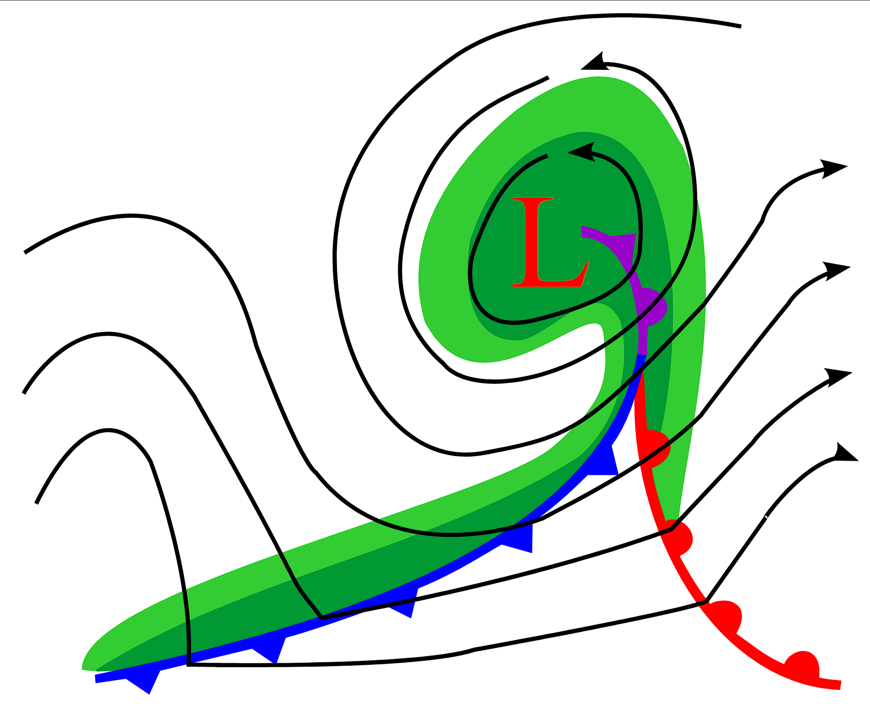
How do cold fronts form? It comes down to the movement of a dense, cold air mass displacing a warmer, less dense air mass. As the cold air pushes under the warmer air, it acts like a wedge, forcing the warm, moist air upward to create the characteristic temperature gradient and instability associated with frontal zones.
Key takeaways
Cold fronts develop when a high-latitude, dense cold air mass advances into a region occupied by warmer, lighter air.
The heavier cold air mechanically lifts the warm air into the troposphere, triggering cloud formation, precipitation, and sudden wind shifts.
Synoptic meteorology charts display cold fronts as solid blue lines marked with triangles pointing in the direction of the advancing cold air.
Because cold air is dense and resists modification, cold fronts move significantly faster and have a steeper slope than warm fronts.
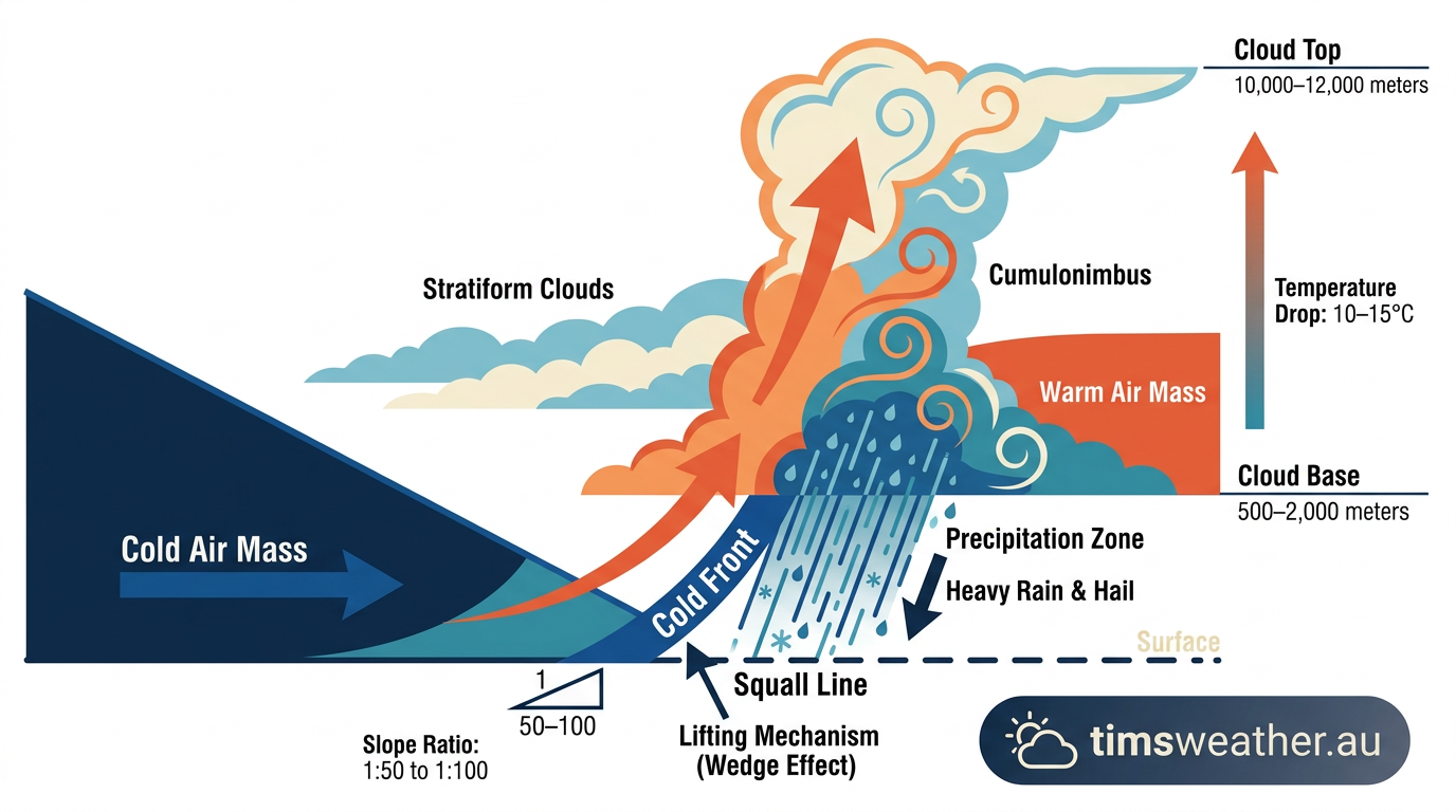
Infographic demonstrating how do cold fronts form by wedging cold air under warm air
Frontogenesis: how do cold fronts form
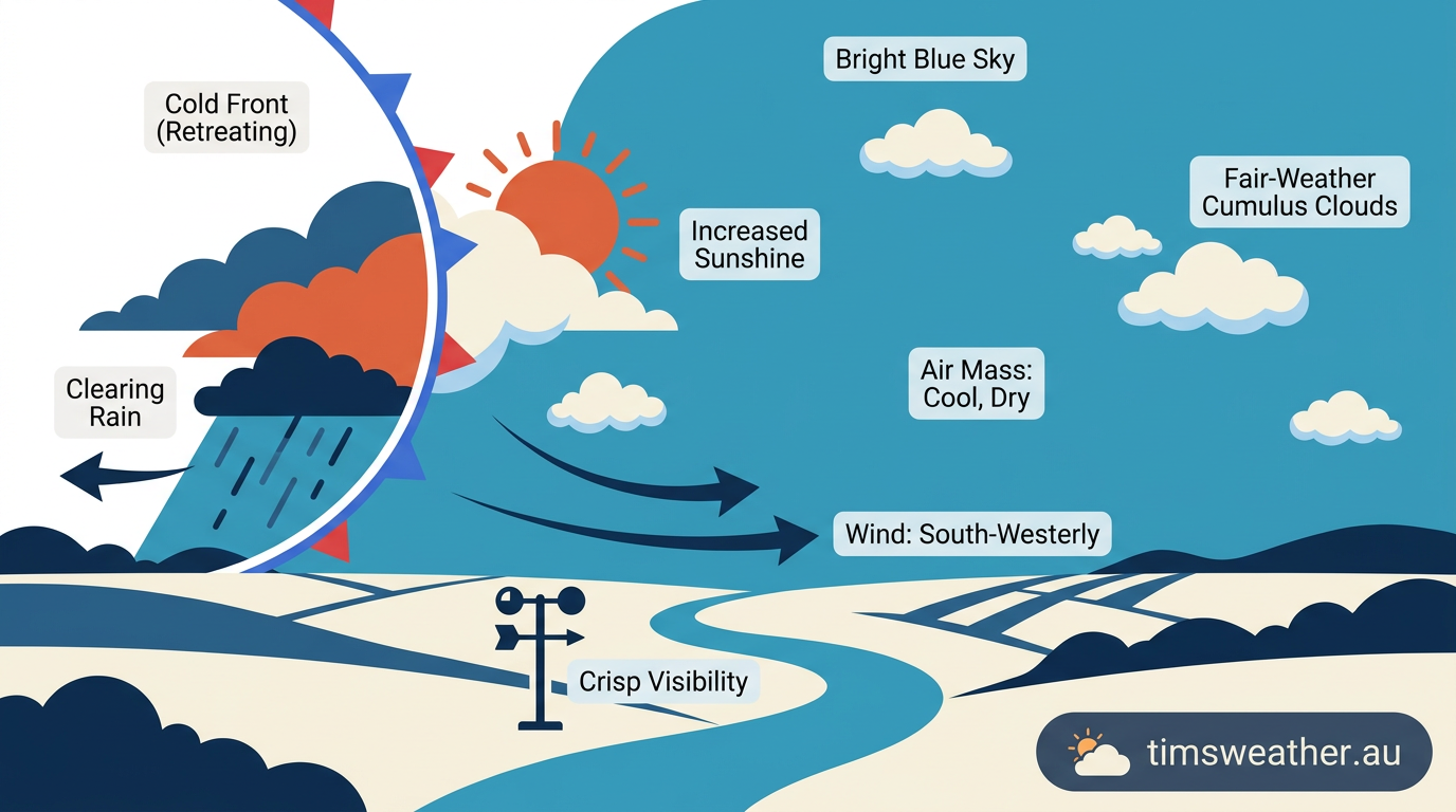
Clear blue skies and dropping humidity following the passage of a cold front
To understand the exact process of frontogenesis, we must look at the global atmospheric circulation. The Earth is constantly trying to balance its heat by moving thermal energy from the equator toward the poles. Large high pressure cells transport polar air toward the equator, while adjacent low pressure systems draw tropical air toward the poles. Where these differing Australian air masses or global air masses meet, they do not mix easily. Instead, they form distinct transition zones.
What triggers the formation of a cold front?
A cold front is triggered when atmospheric pressure systems drive a cold, dense air mass into a region currently occupied by a warmer air mass. This process is driven by the rotation of the Earth and the Coriolis effect, which steers large-scale winds across the surface. As the cold air advection intensifies, it begins to push the existing warm air out of the way. The boundary where this active displacement occurs becomes the cold front. The continuous push of polar air maintains the boundary, as explained by the Bureau of Meteorology in their educational guides.
How synoptic meteorology drives frontal development
The surface boundary does not operate in isolation. It is heavily influenced by the jet stream and upper-level divergence. When the jet stream flows overhead, it can ventilate the atmospheric column, removing mass from the top of the troposphere faster than it flows in at the bottom. This process deepens the surface low pressure system and accelerates the cold front wrapping around it. As the central pressure of the extratropical cyclone drops, the winds around it strengthen, driving the cold air forward with greater kinetic energy.
The interaction between temperature gradients and wind shear
The transition from a diffuse temperature gradient to a sharp frontal zone relies on both wind speed and wind direction. In the initial stages, the temperature difference between the two air masses might be gradual. However, as the associated low pressure system strengthens, converging winds squeeze these air masses tightly together. This convergence increases the horizontal temperature gradient dramatically. Along with this thermal contrast comes a sharp shift in wind direction, creating horizontal wind shear right along the front. This combination of strong thermal contrast and wind shear is what gives a mature cold front its defined structure.
Structural profile of a cold front
A frontal boundary is not just a line on a map. It is a three-dimensional surface extending from the ground high into the layers of the atmosphere. The Norwegian Cyclone Model, developed in the early 20th century, remains the standard for understanding how these boundaries structure themselves around an extratropical cyclone.
The role of density differences in air mass displacement
The fundamental engine of a cold front is density. Cold air molecules are packed more tightly together than warm air molecules, making cold air heavier. When the two masses collide, the dense cold air stays near the ground and forcefully wedges itself underneath the lighter warm air. The slope of a cold front is quite steep, typically ranging from a 1:50 to 1:100 ratio. This means for every 50 to 100 kilometres you move horizontally ahead of the surface boundary, the cold air wedge rises one kilometre into the sky. This physical lifting is a primary trigger for intense weather, a concept widely taught in university meteorology courses hosted on LibreTexts.
Why do cold fronts move faster than warm fronts?
Cold fronts move faster than warm fronts because cold air is denser and heavier, allowing it to forcefully push warmer air out of the way and resist modification as it travels. Warm air lacks the density to easily scour out cold air at the surface, slowing the progression of warm fronts. Because of this speed disparity, a cold front will often catch up to a warm front over time, moving at speeds between 30 and 60 km/h depending on the synoptic forcing.
Extratropical cyclones and occluded fronts
In a mature extratropical cyclone, the cold front typically trails to the west or southwest of the central low pressure system. When a fast-moving cold front ultimately overtakes a warm front, it forces the entire warm air sector aloft, entirely detaching it from the surface. This creates an occluded front. The formation of an occluded front marks the mature and decaying stage of the associated extratropical cyclone, as the system has successfully mixed the contrasting air masses and consumed its available energy.
Visualizing cold fronts through surface weather analysis
Weather forecasting relies on accurately mapping these boundaries. The World Meteorological Organization establishes the standards for identifying and plotting frontal systems on global synoptic charts, ensuring that forecasters worldwide use the same visual language.
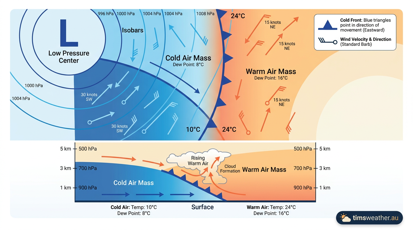
Surface weather analysis chart showing a cold front with blue triangles
How do meteorologists identify cold fronts on surface maps?
Meteorologists identify cold fronts on surface weather maps by looking for a solid blue line adorned with filled blue triangles. The triangles always point in the direction the cold air mass is moving. Observers also look for a sharp temperature drop, a distinct wind shift, and rising atmospheric pressure behind the boundary to confirm the front's exact location. Locating the front requires analyzing high and low pressure systems and their associated wind fields.
Meteorologist's Note: tracking air masses with theta-e charts
Surface temperatures can sometimes be misleading due to local cooling, such as overnight radiative cooling or rain-cooled air from nearby thunderstorms. To find the true synoptic cold front, meteorologists use Equivalent Potential Temperature charts, commonly called theta-e charts. Theta-e combines both temperature and moisture into a single numerical value. A sharp gradient in theta-e cleanly reveals the actual boundary between the warm, moist tropical air and the advancing cold, dry polar air, even when surface thermometers are heavily influenced by local terrain or nighttime cooling.
Analyzing satellite and observational data
Modern forecasters rely heavily on satellite imagery to track frontogenesis. On infrared satellite loops, a cold front often appears as a long, continuous band of bright white cloud tops, indicating deep convection and strong vertical lift. Meteorologists combine this visual data with surface observations, tracking the exact hour the wind shifts and the pressure begins to rise at specific weather stations. This real-time data helps confirm the physical characteristics outlined by weather technology providers like Cordulus.
Weather conditions during frontal passage
The passage of a cold front is one of the most noticeable meteorological events an observer can experience. The sequence of weather changes is highly predictable and driven entirely by the physical lifting of the atmosphere.
The pre-frontal environment
Ahead of the boundary, warm air advection dominates. The air is typically warm and humid, creating an environment rich in latent heat. Clouds begin to thicken, often starting as high cirrus before lowering to altocumulus. The atmospheric pressure steadily falls as the less dense air mass is squeezed and the main low pressure center approaches. Winds typically blow from the north or northwest in the Southern Hemisphere, dragging tropical moisture into the mid-latitudes.
Active boundary crossing and atmospheric instability
As the actual frontal boundary arrives, the weather deteriorates rapidly. The steep slope of the cold wedge forces the warm, moist air into vigorous vertical updrafts. If the atmosphere holds sufficient moisture, this violent lifting dictates how do thunderstorms form along the boundary line. Severe atmospheric instability can organize these storms into long, continuous squall lines.
Aviation authorities warn that cold fronts are uniquely hazardous to aircraft. They produce severe thunderstorms, low-level wind shear, and significant turbulence, which is why pilots study these boundaries extensively in aviation training programs like WiFiCFI. Observers on the ground might notice specific cloud structures during this lifting process. Knowing how do arcus clouds form along the leading edge of the storm outflow gives a visual indicator of the approaching turbulent wind.
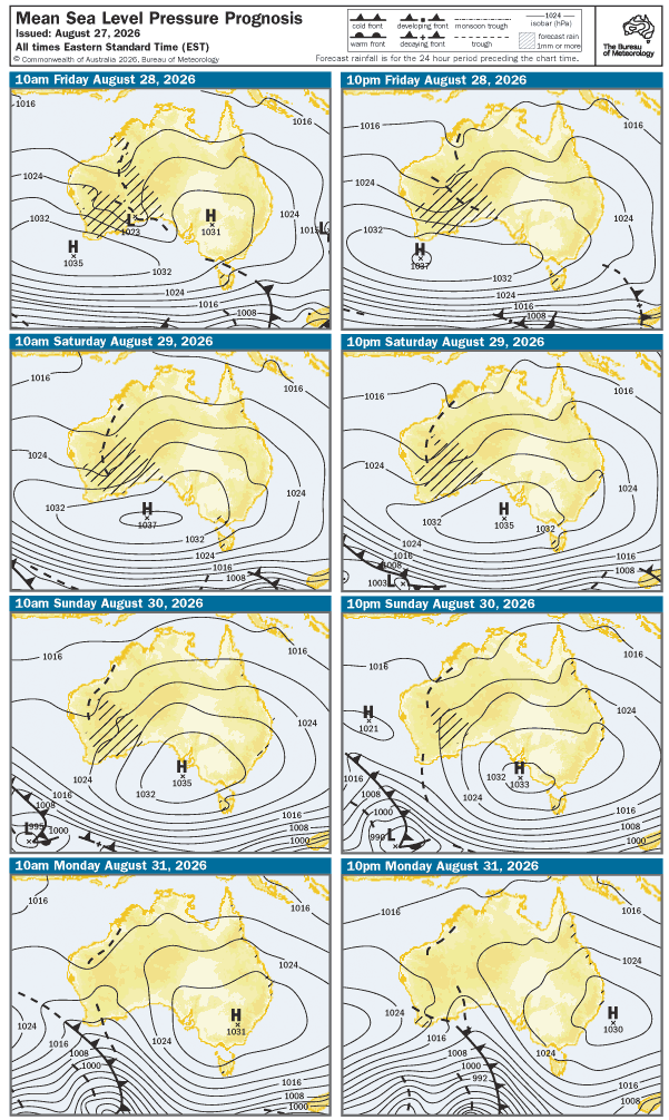
Australian weather prognosis maps illustrate cold front (lines with triangles) movements and pressure systems, vital for understanding how cold fronts form and impact weather. Source: https://reg.bom.gov.au/australia/charts/4day_col.shtml
Post-frontal clearing
Once the front passes, the weather improves quickly. The heavier, colder air floods the region. Because cold air cannot hold as much moisture as warm air, and because the air mass behind the front is generally subsiding rather than rising, the skies clear rapidly. Atmospheric pressure rises sharply as the dense air settles over the area, and humidity levels plummet. The temperature drop can be drastic, with local news outlets like WINK News frequently reporting temperature drops of 10 degrees Celsius or more within a single hour.
How does a cold front differ from a warm front?
A cold front differs from a warm front primarily in its density mechanics and speed. A cold front features dense air actively wedging under warm air, leading to a steep slope, narrow bands of heavy rain, and fast movement. A warm front features lighter warm air passively sliding up and over a retreating cold air mass, resulting in a gentle slope, widespread steady rain, and slower movement.
Structural and kinetic differences
This difference in slope dictates the cloud types observed. While cold fronts generate towering cumulonimbus clouds and heavily localized downpours, warm fronts are characterized by widespread stratus clouds and gentle, continuous precipitation. How nimbostratus cloud formation is key to recognizing the prolonged, gloomy weather typical of warm frontal passages. The table below outlines the primary physical characteristics that differentiate these synoptic boundaries.
Front Type | Kinetic Mechanism | Temperature Change | Primary Weather |
|---|---|---|---|
Cold Front | Dense air undercuts warm air | Sharp, rapid drop | Narrow bands of heavy rain, squalls, thunderstorms |
Warm Front | Warm air overrides cold air | Gradual warming | Widespread steady rain, low visibility |
Stationary Front | Air masses stall side-by-side | Little to no change | Persistent cloud cover, extended light rain |
Occluded Front | Cold front catches warm front | Complex, typically cooling | Mixed precipitation, mature cyclone decay |
Cold fronts across different climate zones
The behaviour and strength of a cold front depend heavily on the latitude and the underlying geography it travels across. The physics of air mass collision change dramatically as systems move from the poles toward the equator.
Mid-latitude dynamics
In the mid-latitudes, the temperature gradient between polar air and tropical air is at its strongest. This stark thermal contrast fuels powerful extratropical cyclones. In these regions, cold fronts are highly active. They are responsible for significant seasonal rainfall and are the primary trigger for supercell thunderstorm formation during the transition seasons of spring and autumn. The density differences provide the immense lift required to break atmospheric capping inversions, initiating deep convection.
The speed of the advancing boundary also plays a role in storm type. A moderately paced front might allow individual storm cells to flourish, while a rapidly accelerating boundary often dictates how multicell thunderstorm formation works, merging isolated convective cells into a massive, organized line of severe weather that sweeps across the sector.
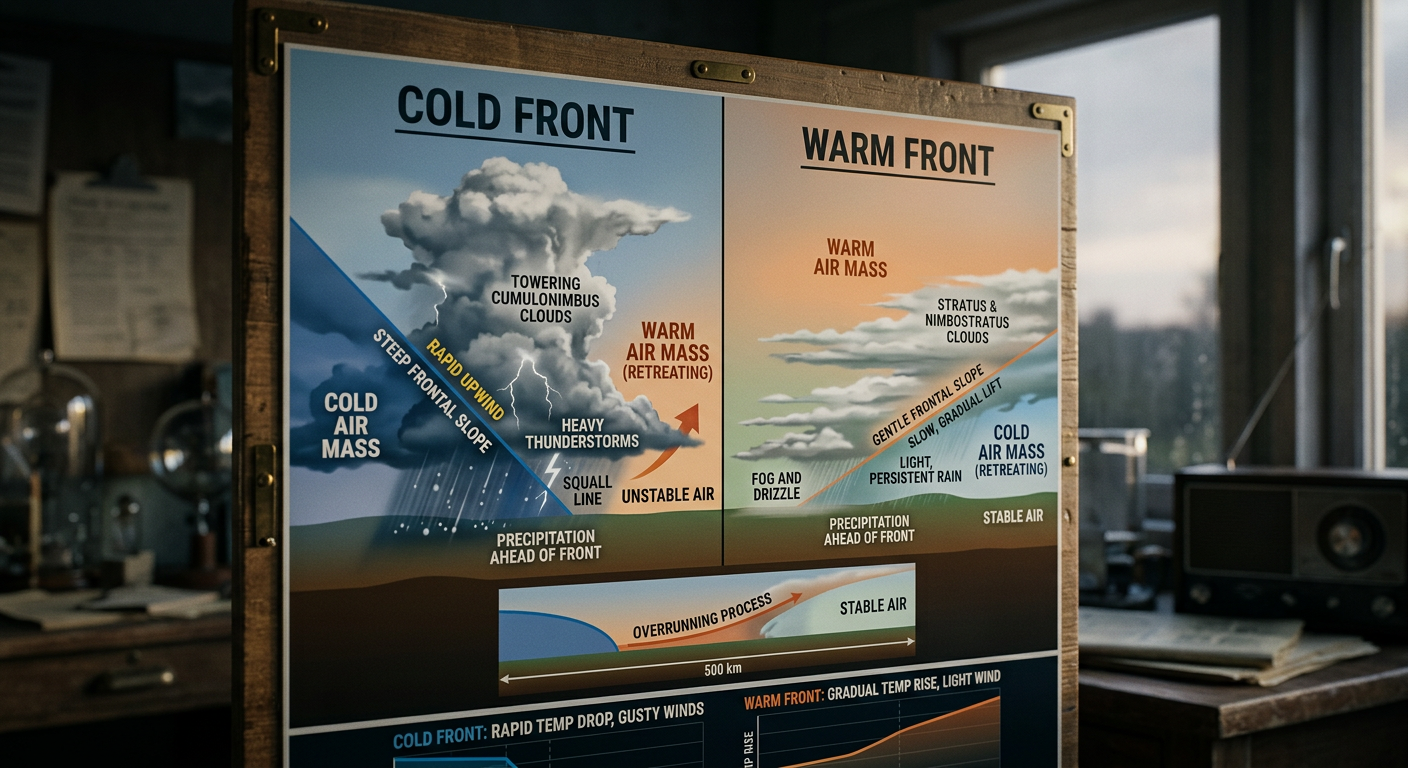
Comparison infographic showing the structural differences between cold and warm fronts
Tropical disturbances vs mid-latitude systems
It is instructive to contrast mid-latitude cold fronts with tropical disturbances where density differences play a different role. In the tropics, the air masses are generally uniform in temperature and humidity. Therefore, strong cold fronts rarely penetrate deep into equatorial regions. Instead of relying on baroclinic zones and sharp temperature gradients, tropical disturbances rely on latent heat release and widespread convergence to generate weather. The mechanics taught in foundational educational weather materials show that without contrasting density, true cold fronts simply cannot exist near the equator.
Subtropical boundary decay
As cold fronts move further toward the equator and enter subtropical zones, their structure begins to break down. The cold air mass passes over increasingly warm ocean waters or sun-heated land, warming the lower layers of the air mass. This process, known as modification, weakens the temperature gradient and erodes the density differences.
Eventually, the distinct temperature change vanishes entirely. The front may slow down and stall, becoming a stationary front, or it may degenerate into a simple shear line. A shear line is a boundary marked only by a shift in wind direction and scattered showers, completely lacking the aggressive temperature drop seen at higher latitudes. The lifecycle of a cold front is an excellent demonstration of the atmosphere's continuous effort to distribute thermal energy evenly across the globe.
Frequently asked questions
Cold fronts form when a mass of colder, denser air moves into a region occupied by warmer air. This cold air acts like a wedge, forcing the lighter, warmer air to rise. This lifting process cools the warm air, triggering the development of clouds, rain, and a noticeable shift in wind.
Source: bom.gov.au
Further reading and resources
Explore trusted articles, books, videos and other resources to go deeper on this topic.
pilotinstitute.comArticle
Weather Fronts Explained (Cold, Warm, Stationary, ...
In-depth coverage on How Do Cold Fronts Form? The Complete Meteorological Guide from pilotinstitute.com.
ebsco.comArticle
Cold fronts and warm fronts | Earth and Atmospheric ...
In-depth coverage on How Do Cold Fronts Form? The Complete Meteorological Guide from ebsco.com.
metlink.orgArticle
Royal Meteorological Society Weather Systems
In-depth coverage on How Do Cold Fronts Form? The Complete Meteorological Guide from metlink.org.
weather.govReference
Basic Discussion on Pressure
Background reference on How Do Cold Fronts Form? The Complete Meteorological Guide from weather.gov.
youtube.comVideo
Ask the Bureau: What is a cold front?
Video coverage on How Do Cold Fronts Form? The Complete Meteorological Guide from youtube.com.
en.wikipedia.orgReference
Cold front
Background reference on How Do Cold Fronts Form? The Complete Meteorological Guide from en.wikipedia.org.
Weather front
Background reference on How Do Cold Fronts Form? The Complete Meteorological Guide from en.wikipedia.org.
scied.ucar.eduReference
Weather Fronts - UCAR Center for Science Education
Background reference on How Do Cold Fronts Form? The Complete Meteorological Guide from scied.ucar.edu.
noaa.govReference
How to read Surface Weather Maps
Background reference on How Do Cold Fronts Form? The Complete Meteorological Guide from noaa.gov.
climavision.comArticle
The Four Types of Weather Fronts Explained
In-depth coverage on How Do Cold Fronts Form? The Complete Meteorological Guide from climavision.com.
Planning weeks ahead?
Check Australia's long-range seasonal outlook for rainfall, temperature and the climate drivers (ENSO, IOD, SAM, MJO) shaping the next three months.
View Australia's Seasonal Weather Forecast