

How does dew form? Dew forms when a surface cools to the dew point through night-time radiative cooling, causing atmospheric water vapour to condense into tiny liquid droplets. It most often happens on clear, calm nights when the ground loses heat quickly and the air beside it reaches saturation.
Key takeaways
- Grass blades, metal and glass cool faster than other materials, explaining why morning condensation often appears on them first.
- Clear nights usually produce heavier dew because cloud cover slows heat loss from the ground.
- Light winds often help dew form, but stronger wind can mix in drier air and reduce it.
- The dew point is a better guide to moisture content than relative humidity alone.
- If the surface drops below 0 °C, moisture forms frost by deposition instead of liquid dew.
The science of condensation: how does dew form?
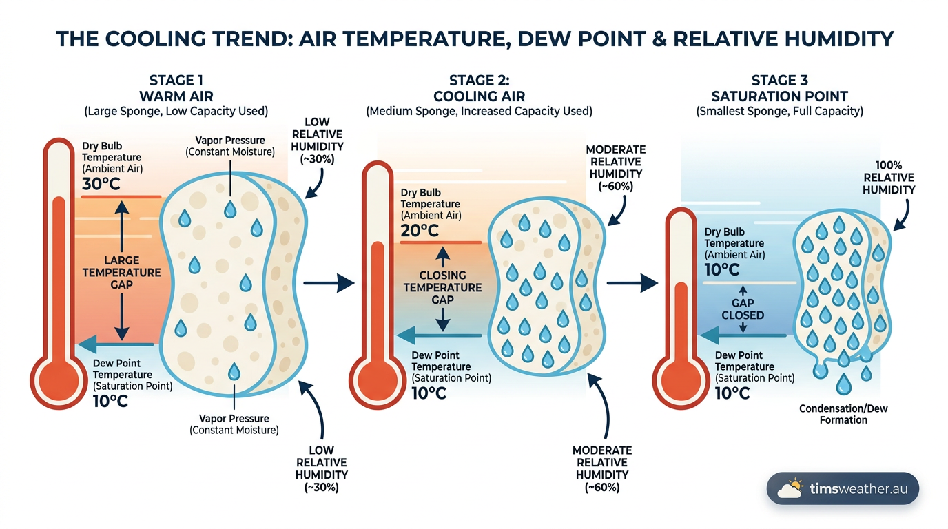
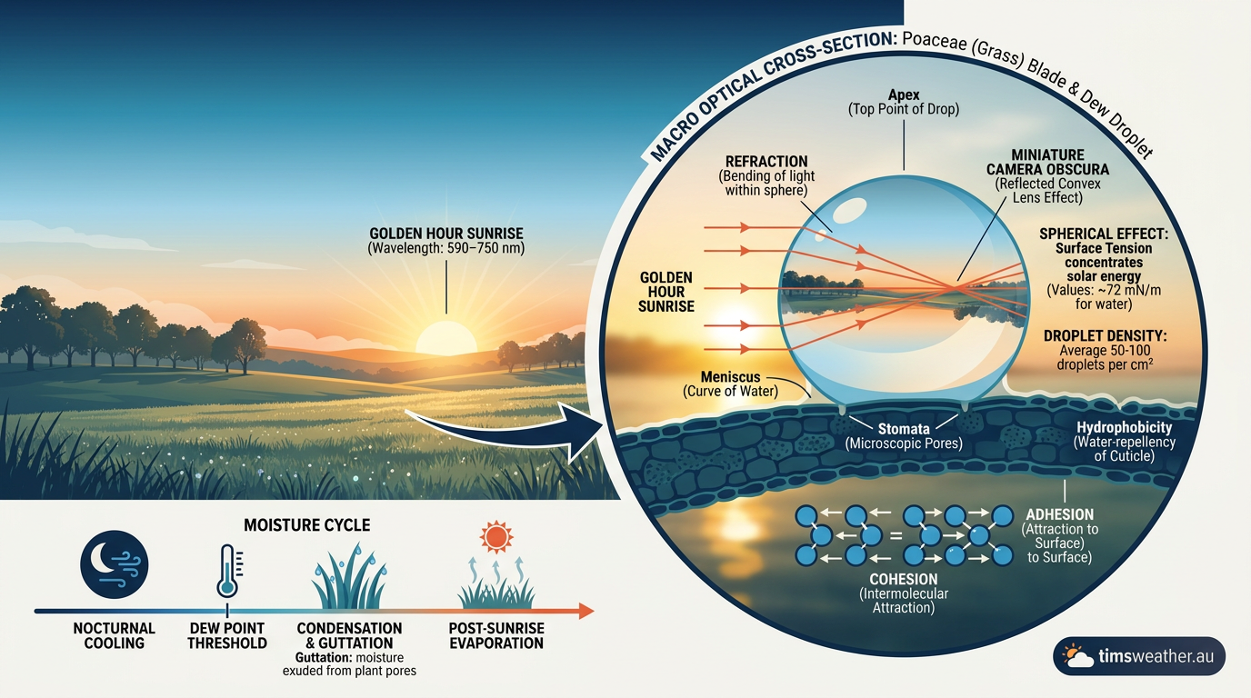
Dew forms when the air touching a cool surface reaches saturation and can no longer keep all of its water vapour in gas form. The Bureau of Meteorology (BOM) uses dew point and relative humidity to describe that moisture state because both values help show how close the air is to condensation. If you want the short version, dew is just the visible result of water vapour turning back into liquid on a cold surface.
What happens first on a clear night?
After sunset, the ground starts losing heat. It does this mainly through thermal radiation, which is the release of energy from the surface into the night sky. As the surface cools, the thin layer of air touching it also cools by conduction. Once that air reaches its dew point temperature, the condensation process begins and droplets appear on grass, cars, railings and other exposed objects.
This is why dew often shows up first on surfaces that cool quickly. Grass blades, metal and glass can lose heat faster than deeper or better-insulated materials. The surface temperature matters more than the air temperature at head height, because dew forms where the cooling is strongest.
Why cloudless nights lead to heavier dew
Cloudless nights usually produce more dew because there is less cloud cover to trap outgoing thermal radiation. With a clear sky above, the ground can lose heat more efficiently, and the surface temperature falls faster. That makes it easier for the air next to the ground to reach saturation.
Clouds act a bit like a blanket. They absorb some of the outgoing radiation and send part of it back down, which slows night-time radiative cooling. If the surface does not cool enough, the dew point is never reached and the ground stays dry.
How wind speed affects dew formation in Australia
Wind speed matters because dew needs a thin, cool layer of air sitting over the surface. When the air is very still, that layer can cool in place and moisture can condense. When the wind is stronger, it mixes the air near the ground with drier air from above, which makes it harder for the surface layer to stay saturated.
That is why light winds are often linked with heavier dew in Australia, especially inland where clear skies and large overnight temperature drops are common. If you are checking for a damp start to the morning, a calm forecast is one of the best clues.
Dew point temperature versus relative humidity
The dew point temperature tells you how much moisture is really in the air. Relative humidity tells you how close the air is to saturation at its current temperature. They are related, but they do not mean the same thing.
What is the dew point temperature?
The dew point is the temperature to which air must be cooled, at constant pressure, for saturation to occur. A higher dew point means more atmospheric water vapour is present. In practical terms, that is why a humid summer night feels sticky, while a low dew point usually means dry air.
For weather watchers, the dew point is often the cleaner measure. Relative humidity can rise or fall just because the temperature changes. The dew point gives a more stable sense of the air’s moisture content, which is why it is a useful number in weather glossary explanations and daily forecasts.
How relative humidity fits in
Relative humidity is the amount of water vapour in the air compared with the maximum it can hold at that temperature. If the air cools overnight and the amount of water vapour stays the same, relative humidity rises. When it reaches 100 per cent, the air is saturated.
That is the point where dew can form. If the surface is cold enough, the moisture in the air touching it condenses into droplets. If the temperature keeps falling and the surface drops below freezing, the result changes from dew to frost.
How BOM measures moisture
A hygrometer is the instrument used to measure humidity. Modern weather stations use electronic sensors to estimate relative humidity and dew point, while older instruments used materials that changed shape as moisture changed. BOM observations rely on these measurements to show how much moisture is available for dew, fog or cloud formation.
If you are reading a forecast, look for both temperature and dew point. A small gap between them often means the air is close to saturation and morning dew is more likely.
Conditions required for dew formation

Dew does not appear from moisture alone. You need several conditions to line up at once.
Clear skies and night-time radiative cooling
Clear skies help because the ground can radiate heat away more freely. That stronger night-time radiative cooling pulls the surface temperature down faster. In many parts of Australia, especially inland, a clear autumn or winter night can drop the temperature enough for dew to form before sunrise.
Calm or light winds
Light winds help the cooling process stay local to the ground. Stronger wind can stir warmer or drier air into the surface layer and reduce the chance of saturation. This is one reason sheltered backyards often dew up more than exposed ridgelines.
Enough moisture in the air
There still needs to be enough atmospheric water vapour available for condensation. Dry air can cool sharply overnight and still produce little or no dew. That is why inland dry spells can feel cold without leaving much moisture on the grass.
Why cloud cover effects matter
Cloud cover effects are simple but important. A cloudy sky slows the loss of heat from the ground, while a clear sky speeds it up. That difference changes how quickly the surface reaches the dew point and whether droplets form at all.
This is also why the same suburb can have a wet lawn one morning and a dry one the next. A small change in cloud cover overnight can be enough to tip the balance.
What changes dew into frost?
If the cooling surface falls below 0 °C, liquid dew is no longer the main outcome. Water vapour turns directly into ice by deposition, which creates frost. The reverse process is called deposition, when water vapour changes straight back into ice without becoming liquid first.
You can think of dew and frost as close relatives. Both depend on cooling, saturation and a surface that loses heat faster than the air around it. The difference is the final temperature.
Dew, fog and other nearby weather terms
Dew often appears alongside other forms of near-surface moisture, but it is not the same as fog. If the air remains saturated near the ground and there is enough mixing, you may get fog instead of droplets on a surface.
In coastal areas, moist air moving across a colder surface can also produce advection fog. That is different from dew, but the same basic idea applies. Cooling brings the air closer to saturation, and water then changes phase.
How to read a forecast for dew
If you want to know whether dew is likely, check three things: the overnight minimum temperature, the dew point and the wind. A clear forecast, a small gap between temperature and dew point, and light winds all point towards a dewy start.
- Look for clear or mostly clear overnight skies.
- Check whether winds are light.
- Compare the forecast minimum temperature with the dew point.
- Watch for sheltered spots, such as lawns, roofs and parked cars.
Morning moisture can also be a useful clue for gardeners, golfers and drivers. Wet grass may mean the surface reached saturation overnight, even if the rest of the yard feels dry by breakfast.
Related guides
Frequently asked questions
Dew forms when grass cools through radiational cooling overnight until its surface temperature reaches the dew point. At this temperature, the air immediately surrounding the blades becomes saturated, causing water vapour to condense into liquid droplets on the cooler surface. This process occurs most effectively during calm, cloudless nights.
Source: biologyinsights.com
Further reading and resources
Explore trusted articles, books, videos and other resources to go deeper on this topic.
weather.govReference
DEW AND FROST DEVELOPMENT
Background reference on How Does Dew Form? Dew Point, Condensation and Radiative Cooling Explained from weather.gov.
neonscience.orgArticle
What's All This Dew Doing? Maybe More Than You Think
In-depth coverage on How Does Dew Form? Dew Point, Condensation and Radiative Cooling Explained from neonscience.org.
barringtonfarmschool.orgArticle
Where Does Dew Come From?
In-depth coverage on How Does Dew Form? Dew Point, Condensation and Radiative Cooling Explained from barringtonfarmschool.org.
sensorpush.comArticle
Understanding Dew Point
In-depth coverage on How Does Dew Form? Dew Point, Condensation and Radiative Cooling Explained from sensorpush.com.
en.wikipedia.orgReference
Dew point
Background reference on How Does Dew Form? Dew Point, Condensation and Radiative Cooling Explained from en.wikipedia.org.
Dew Point vs Humidity - National Weather Service
Background reference on How Does Dew Form? Dew Point, Condensation and Radiative Cooling Explained from weather.gov.
stadlerform.comArticle
Dew point and condensation simply explained
In-depth coverage on How Does Dew Form? Dew Point, Condensation and Radiative Cooling Explained from stadlerform.com.
vaisala.comArticle
What is dew point and how to measure it? - Vaisala
In-depth coverage on How Does Dew Form? Dew Point, Condensation and Radiative Cooling Explained from vaisala.com.
vaia.comArticle
Why does dew form on the ground during clear, calm summer ...
In-depth coverage on How Does Dew Form? Dew Point, Condensation and Radiative Cooling Explained from vaia.com.
hal.scienceArticle
Radiative cooling for dew condensation
In-depth coverage on How Does Dew Form? Dew Point, Condensation and Radiative Cooling Explained from hal.science.
Planning weeks ahead?
Check Australia's long-range seasonal outlook for rainfall, temperature and the climate drivers (ENSO, IOD, SAM, MJO) shaping the next three months.
View Australia's Seasonal Weather Forecast