
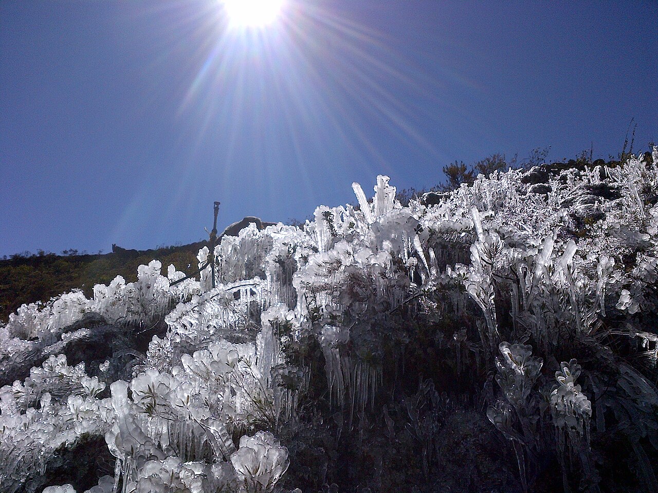
How does frost form? Frost forms when water vapour in the air bypasses the liquid stage and changes directly into ice crystals through deposition. This happens when a surface cools through radiative cooling to 0 °C or below, while the air just above it can still sit a little warmer.
Key takeaways
At 1.2 metres high, official weather screens often record warmer air than the ground, where surface ice actually grows.
Surface temperature can fall below air temperature, so ground frost can appear when the thermometer is still above 0 °C.
Clear skies, light winds and enough water vapour near the ground are the main ingredients for frost.
Black frost can damage plant tissues even when there is little or no visible white ice.
Cold air pools in valleys, inland basins and the Australian alpine regions, which raises frost risk on calm nights.
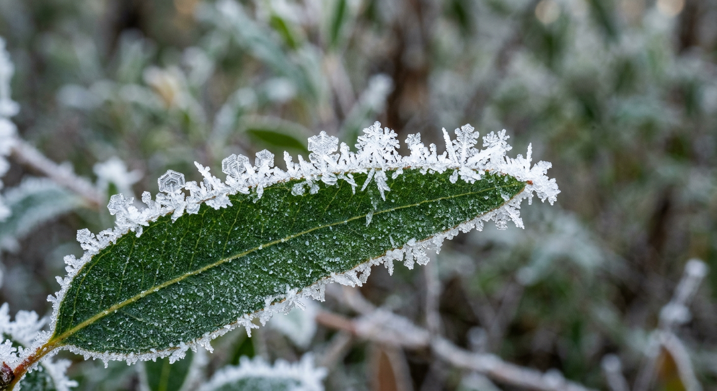
Close-up macro photo showing ice crystals forming frost on a green leaf.
How does frost form through deposition?
Frost forms when water vapour changes directly into ice on a cold surface. The Bureau of Meteorology uses the same basic idea in frost forecasting, which focuses on the surface cooling enough for ice crystals to grow before sunrise.
People often think frost is frozen dew, but that is not the usual process. Dew forms first as liquid water, which you can read more about in dew point and how does dew form. Frost is different because the water vapour skips the liquid stage. That direct change from gas to solid is called deposition.
The role of latent heat
When water vapour deposits as ice, it releases latent heat. That heat release is small, but it does slow further cooling for a short time. The surface can still keep cooling through the night, especially under clear skies and light winds. The reverse process is sublimation, when ice changes straight back into water vapour.
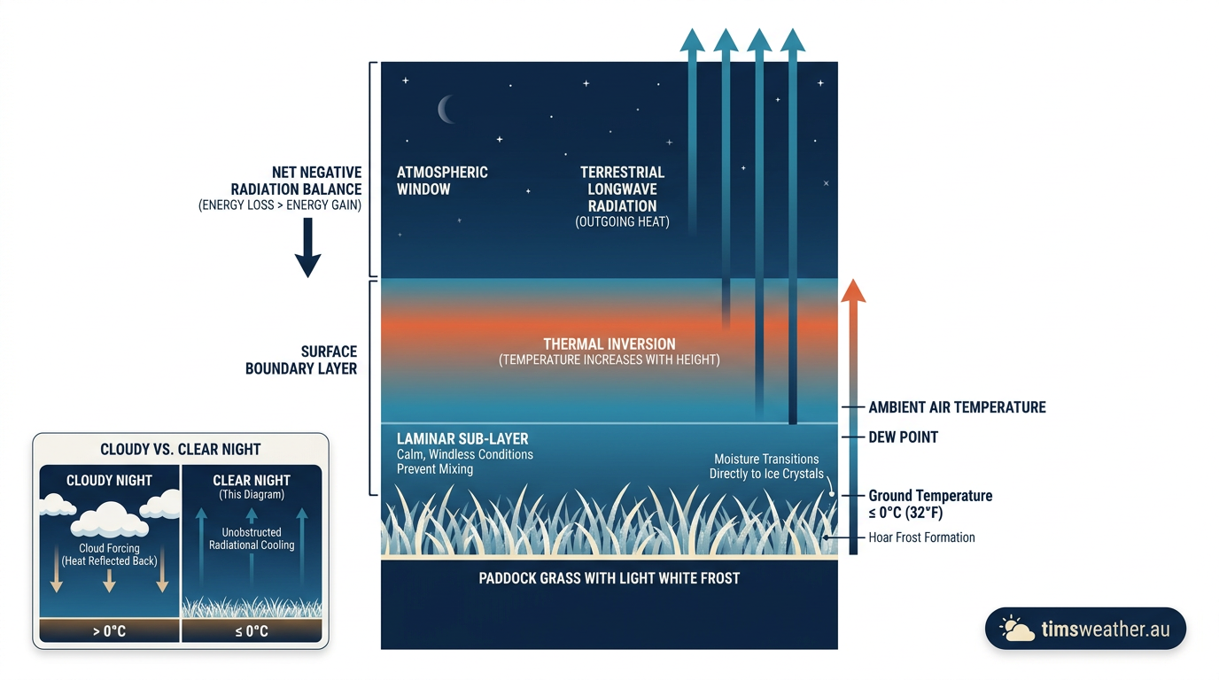
A wide view of a paddock covered in ground frost under a clear night sky.
What weather conditions favour frost?
Frost is most likely on clear, calm nights with enough moisture in the air. The short version is simple: the surface loses heat faster than the air can replace it.
Radiative cooling on clear nights
After sunset, the ground gives off heat as longwave radiation. This is called radiative cooling. Clouds act like a lid because they absorb some of that outgoing heat and send part of it back down. On a clear night, more heat escapes to the sky, so the surface cools faster.
That is why frost often forms in sheltered places overnight, then disappears after sunrise once the surface warms again. The surface can also cool more than the air a couple of metres above it, so the temperature at grass height may be lower than the official reading in a screen.
Light winds and an inversion layer
Light winds help cold air stay near the ground. If winds are strong, they mix warmer air down and make frost less likely. Calm conditions also help create a near-surface inversion layer, where the coldest air sits at ground level and warmer air sits above it.
These patterns are common under high pressure systems, which usually bring clear skies and light winds. For a broader view, see High and low pressure systems.
The role of night-time radiative cooling in Australian inland basins
Australian inland basins can cool very fast overnight because cold air drains downhill and pools in low-lying areas. Clear, dry air also lets heat escape more freely, so the surface temperature can fall sharply before dawn.
That is why some valleys, basins and the Australian alpine regions are more frost-prone than nearby higher ground. The same setup can also affect orchard country and sheltered paddocks, especially on still winter and spring nights.
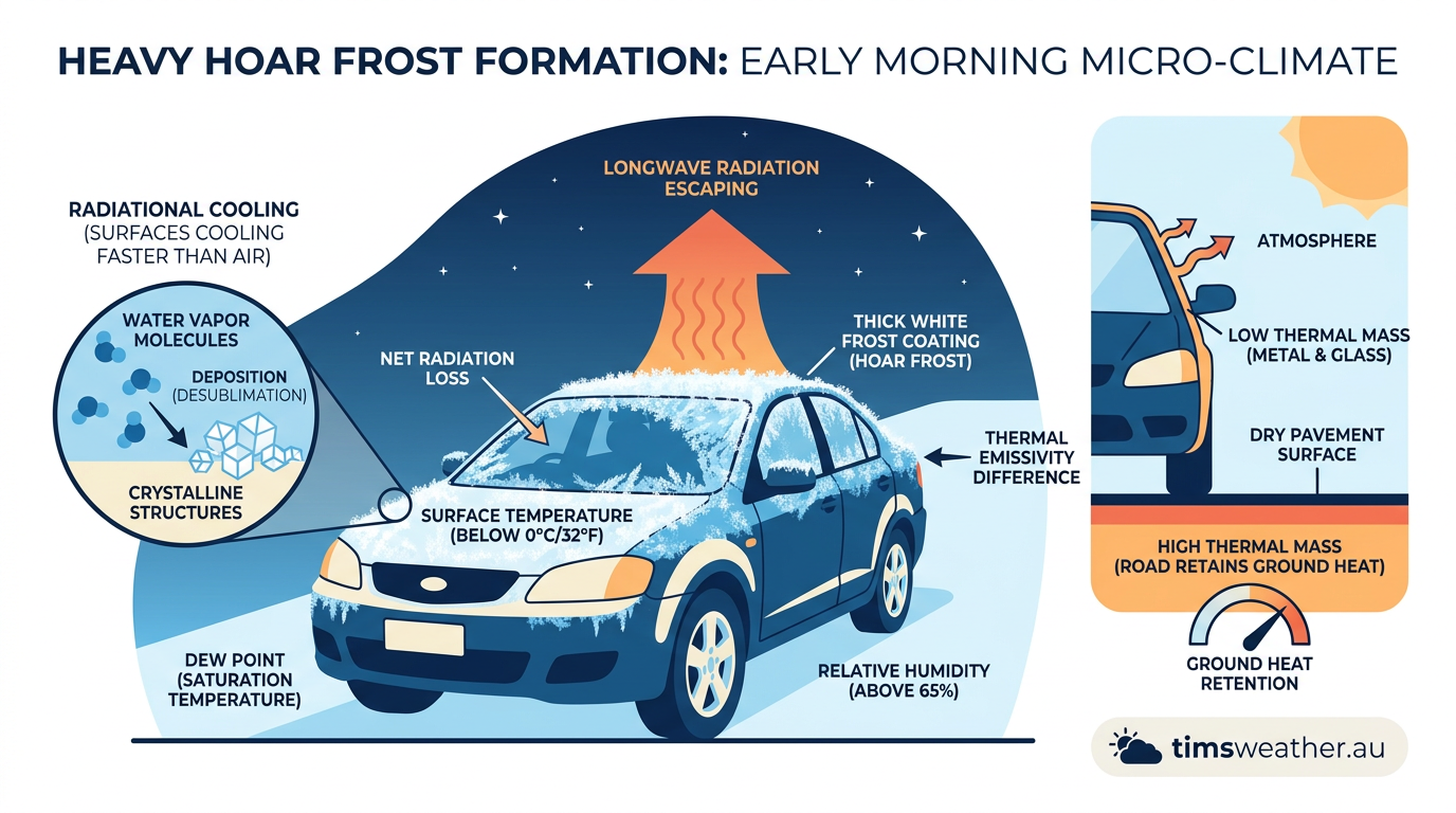
A thick layer of white frost covers the glass windshield and metal roof of a parked car on a dry morning.
Why frost can form when the air temperature is above 0 °C
Surface temperature and air temperature are not the same thing. Official air observations are taken in a screen about 1.2 metres above the ground, while grass, soil, cars and leaves can cool faster than the air above them. That is why you can see ground frost when the thermometer still reads a little above 0 °C.
Once the surface drops to 0 °C or below, frost can form even if the air at screen height is slightly warmer. The key point is the temperature right at the surface, not just the number on the local weather station.
Comparing frost types
Frost can look different depending on moisture, temperature and how cold the surface gets overnight.
Frost type | Formation process | Visual characteristics | Typical location |
|---|---|---|---|
Hoar frost | Water vapour deposits directly onto a freezing surface. | White, feathery or needle-like ice crystals on edges. | Open paddocks on calm, clear mornings. |
Ground frost | Radiative cooling lowers soil and grass temperature first. | A white coating on lawns, roofs and exposed surfaces. | Sheltered valleys and residential lawns. |
Black frost | Air is too dry for visible ice crystals, but plant tissue still freezes. | Plants look dark, wilted or scorched without white ice. | Inland farming areas during dry cold snaps. |
What is hoar frost?
Hoar frost is the classic white frost that grows into fine, pointed crystals on fences, grasses and tree branches. It forms when water vapour deposits directly onto a surface that is below freezing. The crystal shape depends on wind, humidity and how quickly the surface cools.
What is black frost?
Black frost is a plant-damaging frost that may leave little or no visible ice behind. In dry air, plants can still freeze even when the moisture is too low for white crystals to build up. That is why leaves can darken after a cold night even though the ground looks unchanged. In crops, frozen tissue can damage vegetation cell walls and leave leaves limp or blackened by morning.
How frost affects plants and crops
Plants are most vulnerable when ice forms inside or on top of tender tissue. Freezing can rupture cells, and repeated frost can reduce growth, bruise fruit and damage seedlings. In cold parts of Australia, growers watch the dew point, surface temperature and overnight wind forecast closely.
Moisture matters too. Hygroscopic nuclei are tiny particles that help water droplets form in the air. They are more familiar in cloud physics than frost, but they still help explain why moisture can gather differently around dust, smoke and other particles near the ground.
Related guides
Frequently asked questions
Frost forms when surfaces such as grass cool to 0°C or lower, typically on clear, calm nights. Water vapour in the air then turns directly into ice crystals on the cold surface through a process called deposition, rather than becoming liquid dew first. This creates the familiar white coating.
Further reading and resources
Explore trusted articles, books, videos and other resources to go deeper on this topic.
fao.orgArticle
Frost protection: fundamentals, practice, and economics - Volume 1
In-depth coverage on How Does Frost Form? The Science of Deposition and Night-Time Cooling from fao.org.
kwqc.comArticle
Science behind frost formation - KWQC
In-depth coverage on How Does Frost Form? The Science of Deposition and Night-Time Cooling from kwqc.com.
en.wikipedia.orgReference
Frost - Wikipedia
Background reference on How Does Frost Form? The Science of Deposition and Night-Time Cooling from en.wikipedia.org.
Science behind frost formation - KWQC
In-depth coverage on How Does Frost Form? The Science of Deposition and Night-Time Cooling from kwqc.com.
columbiatribune.comArticle
How science explains the morning frost you're starting to see
In-depth coverage on How Does Frost Form? The Science of Deposition and Night-Time Cooling from columbiatribune.com.
weather.govReference
DEW AND FROST DEVELOPMENT
Background reference on How Does Frost Form? The Science of Deposition and Night-Time Cooling from weather.gov.
education.nationalgeographic.orgArticle
Frost - Education | National Geographic Society
In-depth coverage on How Does Frost Form? The Science of Deposition and Night-Time Cooling from education.nationalgeographic.org.
What Causes Frost? - National Weather Service
Background reference on How Does Frost Form? The Science of Deposition and Night-Time Cooling from weather.gov.
actionnews5.comArticle
Breakdown: Why temperature is key in frost formation - Action News 5
In-depth coverage on How Does Frost Form? The Science of Deposition and Night-Time Cooling from actionnews5.com.
wxguys.ssec.wisc.eduReference
How does frost form?
Background reference on How Does Frost Form? The Science of Deposition and Night-Time Cooling from wxguys.ssec.wisc.edu.
Planning weeks ahead?
Check Australia's long-range seasonal outlook for rainfall, temperature and the climate drivers (ENSO, IOD, SAM, MJO) shaping the next three months.
View Australia's Seasonal Weather Forecast