
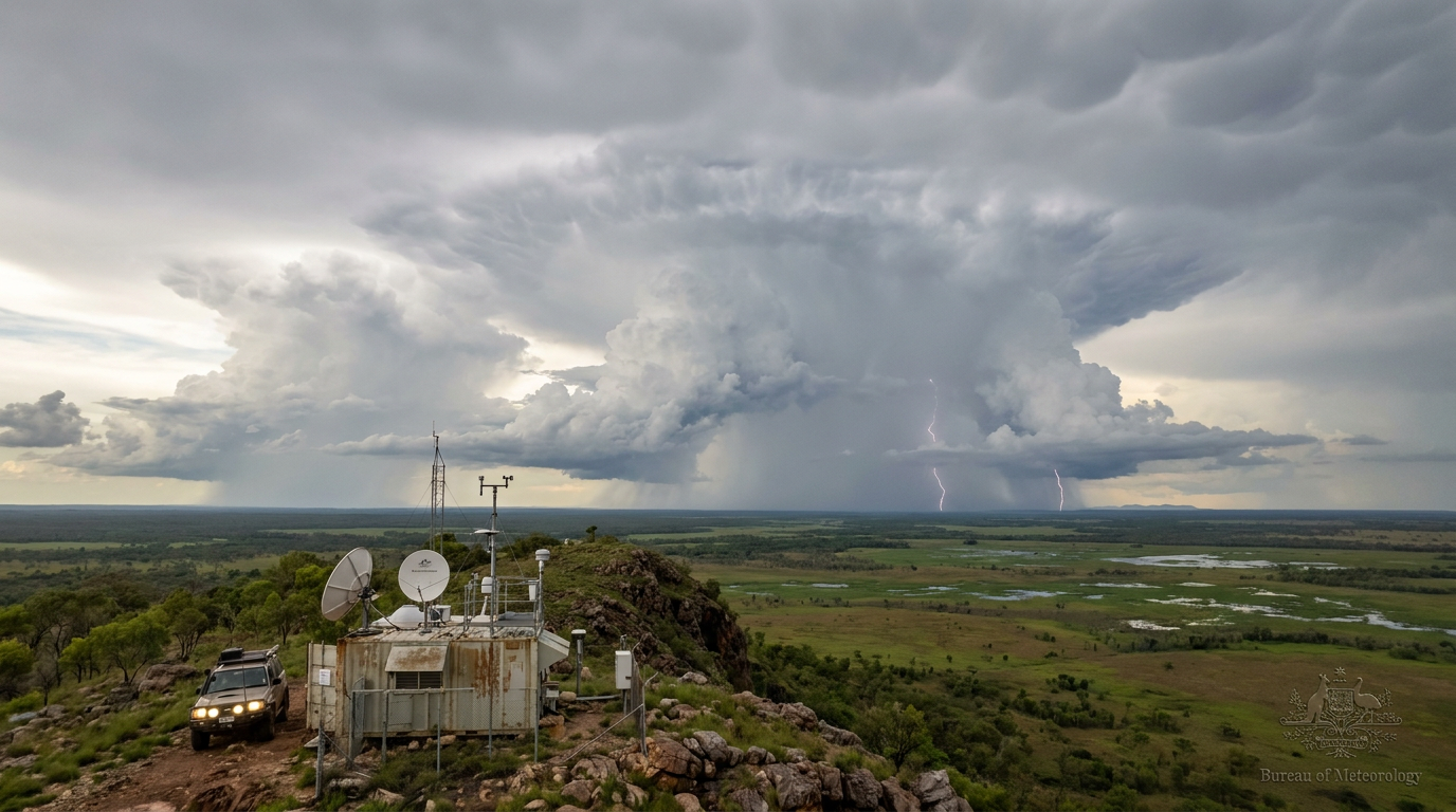
Mesoscale convective system formation occurs when individual thunderstorms aggregate into a large, organised complex driven by convective initiation along an outflow boundary. As cold pools merge, vertical wind shear tilts the updrafts, sustaining a long-lived system characterised by both a leading convective line and a broad trailing stratiform precipitation area.
Key takeaways
- Mesoscale convective systems develop when isolated storm cells merge along shared outflow boundaries to form a single, self-sustaining weather engine.
- A delicate balance of vertical wind shear and atmospheric instability keeps these massive complexes alive for hours or even days.
- They produce a vast trailing stratiform precipitation area that accounts for a large percentage of global tropical rainfall.
- Topography and regional wind convergence force the necessary lift to trigger these extensive storm clusters across many continents.
The mechanics of mesoscale convective system formation
How do mesoscale convective systems form?
These systems form when scattered individual thunderstorms organise and merge into a larger, self-sustaining complex. Warm, moist air and severe atmospheric instability provide the thermal energy, while lifting along frontal boundaries or storm outflow forces the air upwards. Vertical wind shear acts as the final vital component, preventing the storm from collapsing on itself and maintaining its structure over several hours.
To see how a field of scattered showers transforms into a contiguous storm, meteorologists look at the transition from isolated cells to organised convective complexes. The baseline requirement for single-cell thunderstorms is a combination of abundant atmospheric moisture, instability, and a lifting mechanism. Standard single cells typically rain themselves out within an hour. They collapse because their own rain-cooled downdrafts fall directly into their updrafts, choking off the supply of warm air.
Mesoscale convective systems overcome this limitation through structural organisation. When a broad lifting mechanism acts on an environment with high convective available potential energy, multiple thunderstorms erupt simultaneously. As heavy rain falls from these initial cells, evaporative cooling creates dense pockets of cold air that sink to the ground and spread outward. These spreading density currents interact with the surrounding warm air, establishing the foundation for a much larger weather event where the interacting storm elements travel as a single unified cloud system.
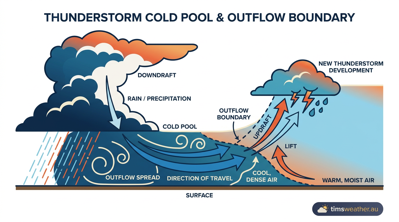
How does a cold pool lead to the formation of an MCS?
A cold pool forms as rain-cooled air sinks to the surface and spreads outwards rapidly. This dense air acts as a heavy wedge, sliding underneath and forcefully lifting the warm, moist air ahead of the system. This continuous lifting along the leading edge acts as a mechanical trigger, firing off new thunderstorm cells that smoothly join the existing cluster and allow the entire system to regenerate.
The boundary where this cool outflow meets the warm inflow is known as an outflow boundary or gust front. As individual cold pools from neighbouring storms merge, they create a unified, storm-scale outflow boundary. Repeated convective initiation along this extensive line allows multiple independent updrafts to consolidate as they actively inhale warm, unstable air through updrafts. Deep-layer vertical wind shear tilts the updrafts away from the downdrafts. This physical separation ensures the rising warm air is no longer suppressed by the falling precipitation.
Internal structure and the Houze model
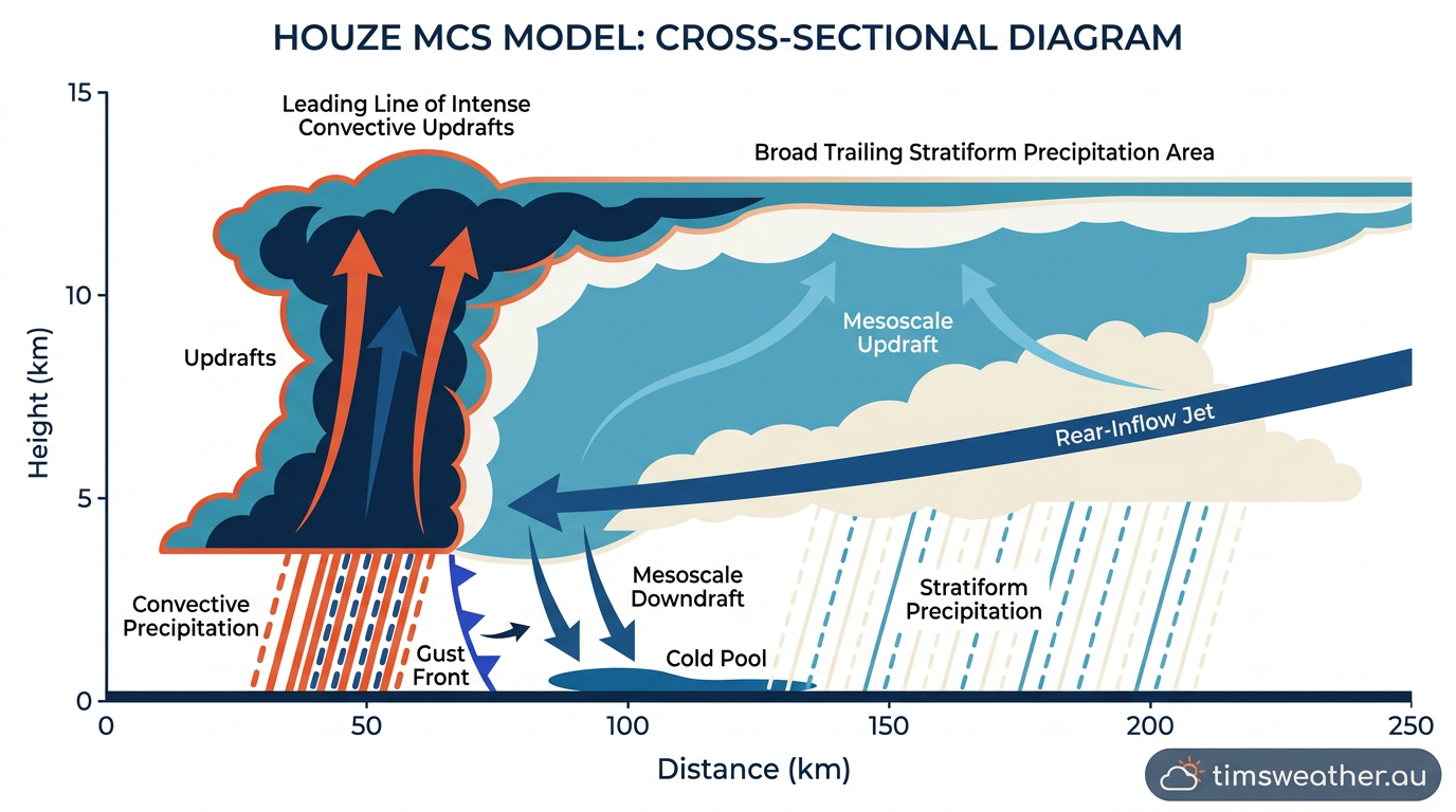
Once the initial cells merge, the architecture of the storm changes completely. Atmospheric science often uses cross-sectional diagrams of the Houze MCS model to explain the mature phase. The model describes two distinct but connected regions within the complex: the active leading convective line and the vast, trailing stratiform precipitation area.
The leading convective line houses the most violent weather. Here, powerful updrafts feed on the unstable air forced upwards by the advancing cold pool. This zone produces the highest rainfall rates, frequent lightning, and severe wind gusts. Behind this intense line, the updrafts weaken and spread out horizontally in the upper troposphere, carrying immense amounts of ice and water vapour over a broad, flat cloud deck.
The role of the rear-inflow jet
As precipitation falls from the upper-level stratiform cloud deck, it evaporates into the drier mid-level air. This evaporation absorbs latent heat, chilling the mid-level air and causing it to become heavier and sink. This sinking motion draws in a stream of drier air from behind the storm, known as the rear-inflow jet. As the rear-inflow jet descends towards the surface, it strengthens the cold pool dynamics, pushing the leading outflow boundary forward even faster.
This internal circulation creates a self-sustaining feedback loop. The stratiform region actively helps maintain the system's longevity. In environments with weak background flow and strong moisture gradients, the latent heat release in the stratiform region can generate an area of low pressure in the mid-levels. The Coriolis effect causes the air flowing into this low pressure to rotate, forming a mesoscale convective vortex. These large vortices can persist long after the parent thunderstorms have dissipated, occasionally serving as the rotational seed for future mesoscale convective systems the following day.
Global drivers and atmospheric waves
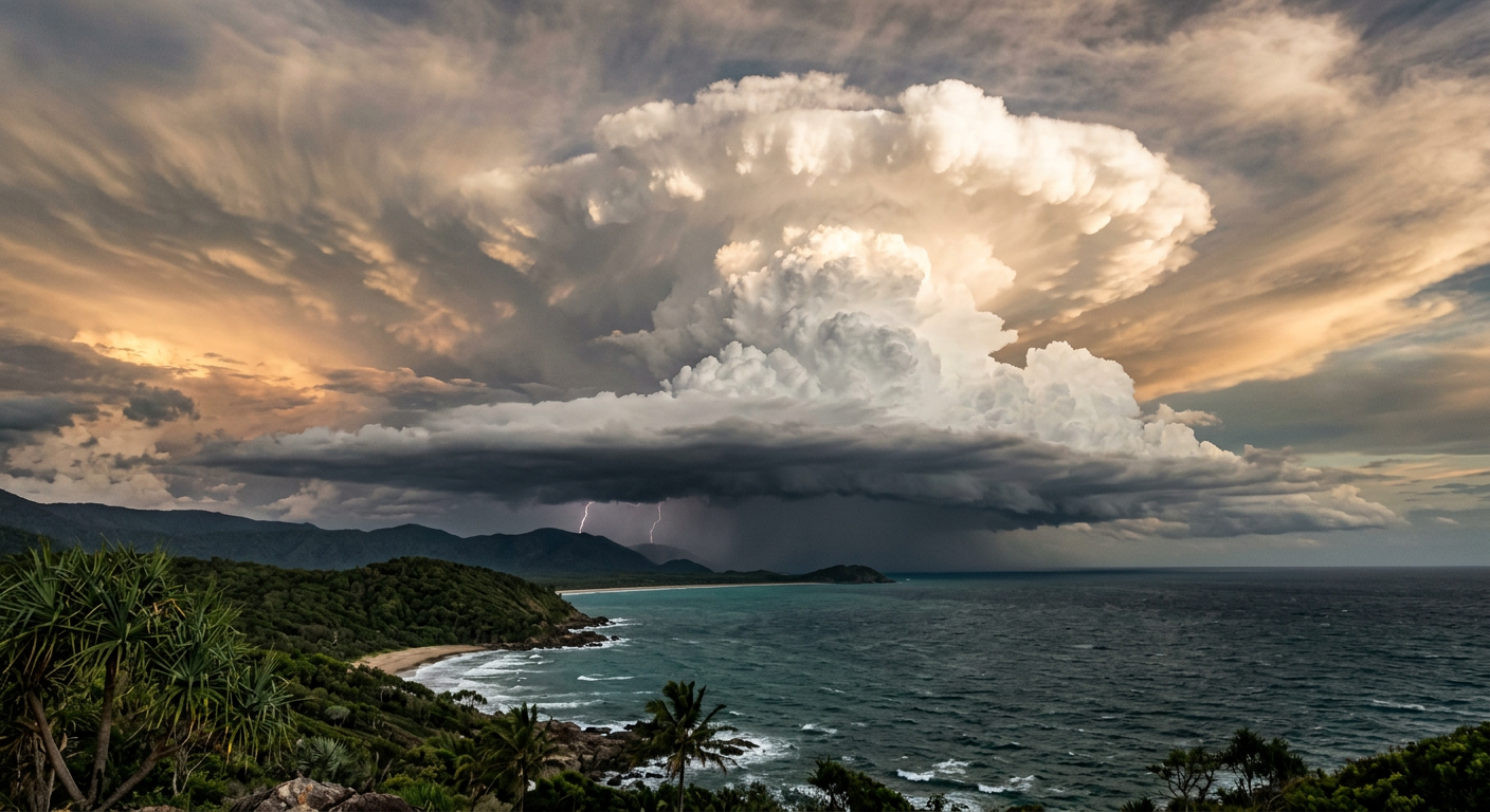
These massive weather systems occur globally, responsible for producing over 50 percent of all tropical rainfall across large organised groups of thunderstorms. In the deep tropics, their development is heavily modulated by large-scale atmospheric waves like the Madden-Julian Oscillation and the seasonal shifts of the Equatorial trough.
In mid-latitude regions, particularly over the plains of North America and parts of the continent influenced by South America Mesoscale Convective Systems, longevity is often driven by a nocturnal low-level jet. During the day, surface heating drives convection. After sunset, the ground cools, but a fast-moving stream of wind just above the surface begins to transport immense quantities of heat and moisture directly into the storm complex. NOAA convective training modules highlight that this nocturnal moisture feed is exactly why many destructive squall lines survive through the night when ordinary thunderstorms decay.
The historical record features many extreme examples of these systems producing widespread destruction. The 29 June 2012 derecho in the United States was a highly organised convective complex that tracked across the Mid-Atlantic, causing massive power outages and severe forest damage. In other parts of the world, terrain heavily influences development. The July 2022 flash flood in northern Tehran was driven by a complex interaction between severe instability and steep mountainous topography, producing a deadly deluge. Meteorologists continuously study the mesoscale convective systems over South Asia to better forecast high-impact flash flood events driven by the summer monsoon.
Australian mesoscale convective patterns
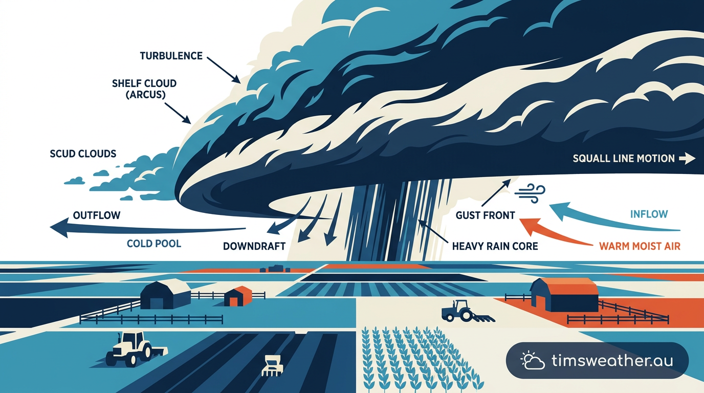
The Australian continent provides a unique laboratory for studying squall lines and extensive storm clusters. The Bureau of Meteorology closely monitors the atmospheric instability and moisture transport across the continent, noting that regional topography and seasonal wind shifts heavily dictate where these systems thrive.
Why are mesoscale convective systems common in Northern Australia?
Northern Australia experiences frequent development of these massive complexes due to the extreme heat and abundant moisture supplied by the Coral Sea and the Gulf of Carpentaria. During the Top End wet season, the Australian Monsoon and the persistent Monsoon Trough create an environment ripe for daily convective initiation. High humidity profiles and strong upper-level divergence allow isolated daytime storms to regularly merge into massive nocturnal rain producers.
One of the most famous, highly predictable manifestations of this process occurs over the Tiwi Islands. Meteorologists refer to this daily occurrence as 'Hector the Convector'. Hector develops when converging sea breezes from the surrounding waters meet over the islands, providing strong mechanical lift. When this lift interacts with the deep-layer shear and high moisture of the wet season, single storms rapidly consolidate into an exceptionally tall and powerful mesoscale convective complex. Similar boundary layer collisions around Cape York Peninsula routinely generate migrating storm clusters.
How do mesoscale convective systems impact Australian rainfall?
Further south, the interaction between available moisture and the Great Dividing Range topography shapes the weather of eastern Australia. During the warmer months, easterly winds push humid ocean air against the mountain ranges. This orographic lift acts as the initial trigger. As cold pools develop and merge, they often organise into multicell thunderstorm clusters or intense squall lines moving rapidly across the Darling Downs and Southeast Queensland.
These severe storm clusters in Queensland are responsible for a large percentage of the region's total summer precipitation. They bring essential agricultural rain to inland farming districts but also pose significant hazards. These hazards include large hail, flash flooding, and damaging straight-line winds powered by the system's rear-inflow jet. How the climatology of mesoscale convective system hazards is vital for public safety, as forecasting requires careful analysis of the deep-layer shear and the available potential energy ahead of the advancing cold pool.
Classifying storm complexes
Meteorologists use specific criteria to categorise these sprawling weather events. A common operational definition is a contiguous precipitation area at least 100 km in one direction. Some tracking studies use a stricter threshold of 30,000 km² for at least 3 hours to identify persistent systems. Within this broad classification, the specific shape and behaviour of the system determine its exact sub-type.
What is the difference between a squall line and a mesoscale convective system?
A squall line is simply one specific structural type of mesoscale convective system. While the overarching term refers to any large, organised cluster of thunderstorms, a squall line specifically describes a system arranged in a long, narrow band. Squall lines are heavily reliant on strong linear forcing mechanisms like cold fronts or well-defined drylines. Other types of convective systems may form large, circular, or irregular clusters rather than distinct lines.
Difference between an MCS and a supercell
While an MCS is a massive cluster of multiple interacting thunderstorm cells spanning tens to hundreds of kilometres, supercell thunderstorms are highly organised, distinct single cells. A supercell is defined by its deep, persistent rotating updraft known as a mesocyclone. Supercells often form in isolation and thrive in environments with extreme directional wind shear. Occasionally, an older supercell may eventually be absorbed into an advancing squall line, losing its isolated rotating characteristics.
How long do mesoscale convective systems typically last?
These systems generally persist for 6 to 12 hours. However, under highly favourable conditions with strong nocturnal moisture transport, they can survive for more than 24 hours. Their longevity heavily depends on the continuous regeneration of new storm cells along the leading gust front, replacing older, decaying cells dropping out at the rear of the complex.
| MCS Type | Structural Characteristic | Primary Forcing Mechanism | Typical Duration |
|---|---|---|---|
| Squall Line | Solid or broken line of intense thunderstorms | Frontal boundaries, strong linear vertical wind shear | 6 to 15 hours |
| Mesoscale Convective Complex (MCC) | Large, circular, continuous cold cloud shield | Low-level jet moisture transport, weak upper flow | 10 to 24+ hours |
| Bow Echo | Bow-shaped line with intense straight-line winds | Strong rear-inflow jet punching through the storm line | 3 to 8 hours |
Identifying the exact type of system developing allows weather agencies to issue accurate, highly specific warnings. By differentiating between a relatively brief bow echo driven by a pattern conducive to derechos, versus a slow-moving mesoscale convective complex likely to cause extensive flooding, emergency services can prepare the public for the exact severe thunderstorms expected.
Frequently asked questions
These systems form when individual thunderstorms organise and merge into a larger, long-lived complex. Warm, moist air and atmospheric instability provide the energy, while lifting along fronts or outflow boundaries triggers development. Vertical wind shear is essential for maintaining the system's structure, allowing it to become self-sustaining over several hours.
Source: weather.gov
Further reading and resources
Explore trusted articles, books, videos and other resources to go deeper on this topic.
foxweather.comArticle
What is a mesoscale convective system?
In-depth coverage on How do mesoscale convective systems form? from foxweather.com.
youtube.comVideo
Beyond the Barometer: What is a mesoscale convective system?
Video coverage on How do mesoscale convective systems form? from youtube.com.
en.wikipedia.orgReference
Mesoscale convective system
Background reference on How do mesoscale convective systems form? from en.wikipedia.org.
schumacher.atmos.colostate.eduReference
Research: Mesoscale convective vortices (MCVs) and their ...
Background reference on How do mesoscale convective systems form? from schumacher.atmos.colostate.edu.
forecast.weather.govReference
NOAA's National Weather Service - Glossary
Background reference on How do mesoscale convective systems form? from forecast.weather.gov.
weather.govReference
MCS CHARACTERISTICS, STRUCTURE, AND ...
Background reference on How do mesoscale convective systems form? from weather.gov.
skybrary.aeroArticle
Mesoscale Convective System (MCS)
In-depth coverage on How do mesoscale convective systems form? from skybrary.aero.
resources.eumetrain.orgArticle
Cumulonimbus (Cb) And Mesoscale Convective System ...
In-depth coverage on How do mesoscale convective systems form? from resources.eumetrain.org.
atmos.washington.eduReference
MESOSCALE CONVECTIVE SYSTEMS - Atmospheric Sciences
Background reference on How do mesoscale convective systems form? from atmos.washington.edu.
ksnblocal4.comArticle
Mesoscale Convective Systems: How they form and the ...
In-depth coverage on How do mesoscale convective systems form? from ksnblocal4.com.
Planning weeks ahead?
Check Australia's long-range seasonal outlook for rainfall, temperature and the climate drivers (ENSO, IOD, SAM, MJO) shaping the next three months.
View Australia's Seasonal Weather Forecast