
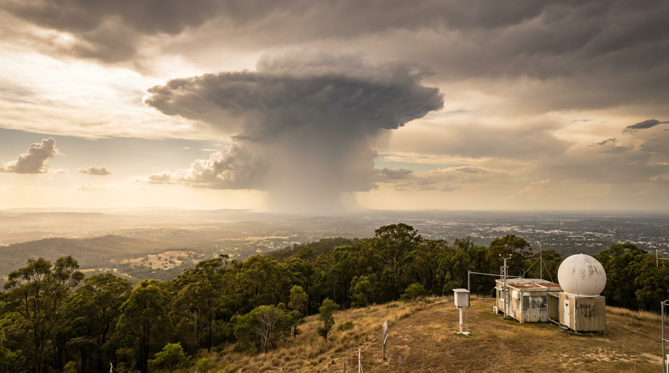
How do single-cell thunderstorms form? These storms develop when boundary layer moisture, atmospheric instability and a lifting trigger combine. A rising parcel builds convective clouds, including cumulonimbus clouds, as it cools at the moist adiabatic lapse rate after condensation begins. In a single-cell thunderstorm, the downdraft eventually cuts off the updraft, so the storm usually lasts less than an hour.
Key takeaways
- Single-cell thunderstorms usually move through three stages: developing, mature and dissipating.
- They need moisture, unstable air and lift, which the Bureau of Meteorology uses as the basic thunderstorm ingredients.
- The storm starts with a strong updraft, then rain-cooled air forms a downdraft.
- Because there is little or no wind shear, the downdraft tends to choke off the updraft.
- These storms are a common type of air mass thunderstorm and often form on hot afternoons.
How do single-cell thunderstorms form?
Single-cell thunderstorms form when a small patch of warm, moist air rises fast enough to build a cumulonimbus cloud. The Bureau of Meteorology describes thunderstorms as needing moisture, unstable air and lift, and that mix is enough to start a simple storm cell if the environment does not support longer-lived organisation. In Australia, these storms are often called air mass thunderstorms because they form inside a warm, humid air mass rather than along a strong front.
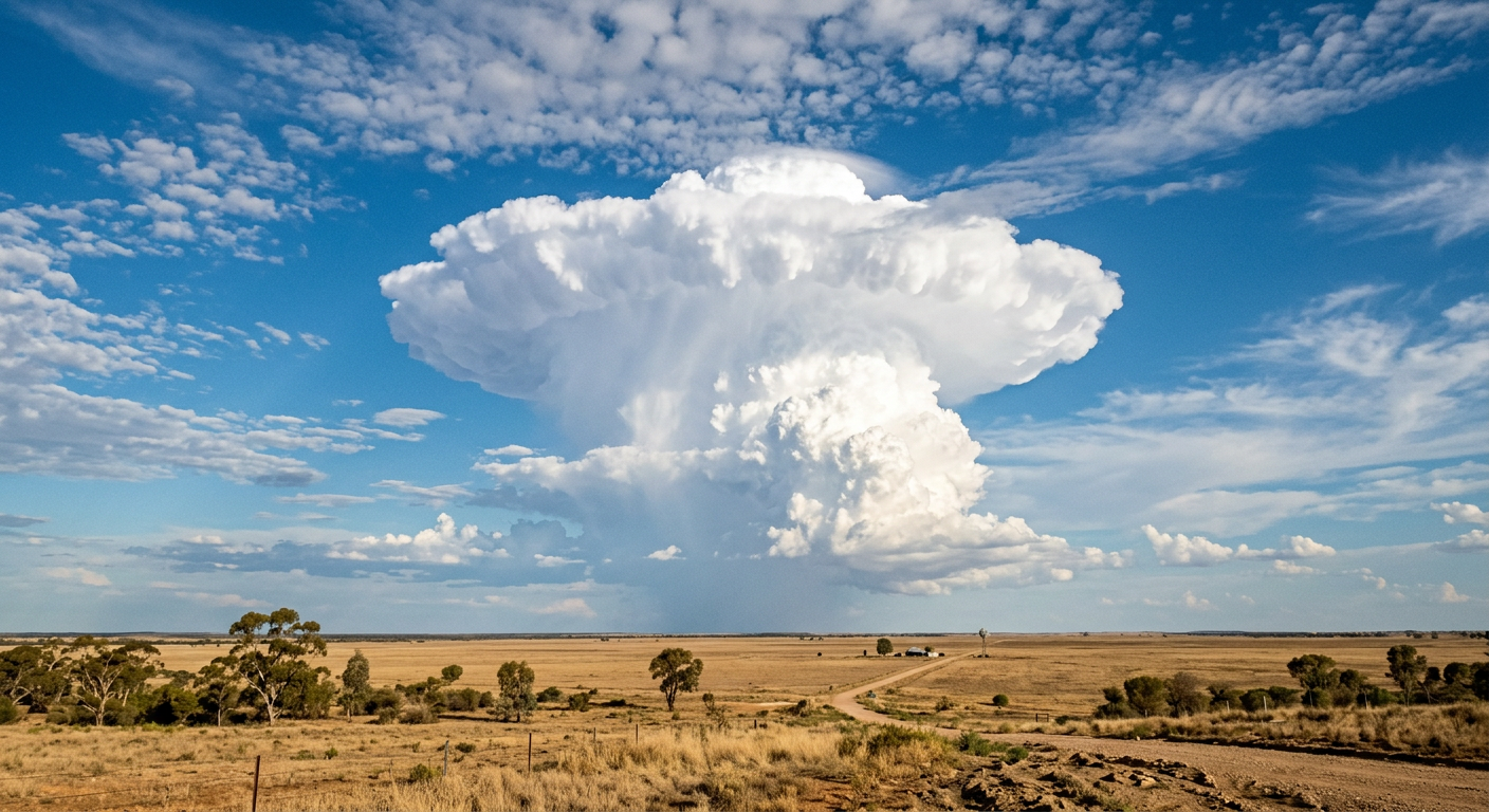
This is a short-lived form of deep convection. Sunlight warms the ground, the air near the surface warms with it, and a parcel of air becomes lighter than the air above. If you are comparing this with broader storm behaviour, how thunderstorms form starts with the same basic lift and instability.
The basic ingredients for thunderstorm formation
The recipe is simple, but the balance has to be right. Thunderstorms need boundary layer moisture, unstable air and a lift mechanism, according to NOAA’s thunderstorm guide and the Bureau of Meteorology’s thunderstorm information. Moist air near the ground gives the storm fuel, unstable air lets parcels keep rising, and lift gets the process started.
Thermal lifting is one of the most common triggers for single-cell storms. On a hot afternoon, a sun-heated paddock, road or rooftop can warm the air just above it. If that air is moist enough, the parcel rises into cooler air and the cloud starts to grow. That is why these storms often appear after the surface has heated for several hours.
Atmospheric instability and parcel theory
Meteorologists use parcel theory to describe this process. A parcel is a small blob of air imagined to rise without mixing with its surroundings. As it rises, pressure falls, the parcel expands and it cools. If the environment cools with height faster than the parcel does, the parcel stays warmer and less dense than the air around it. That is atmospheric instability, and it gives the parcel positive buoyancy.
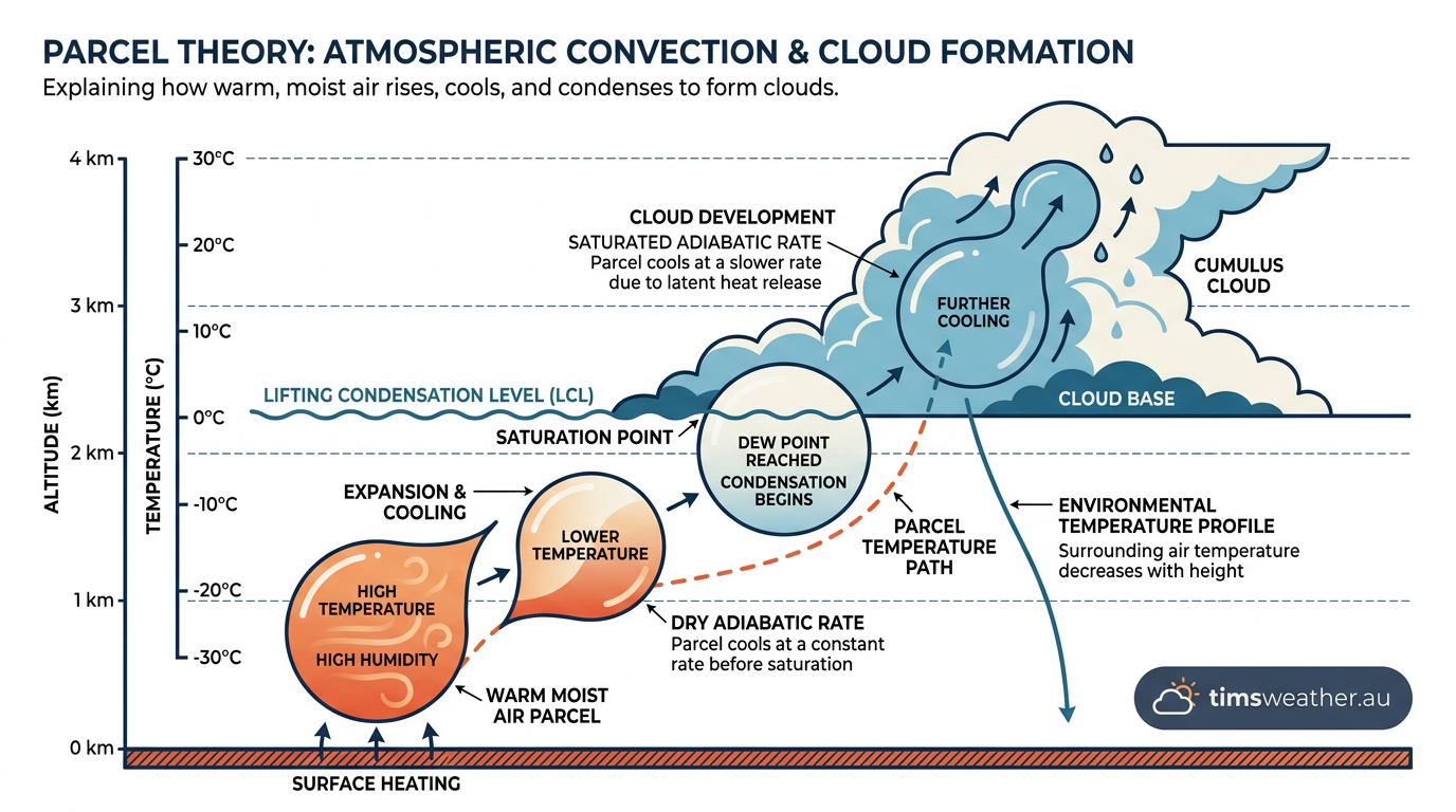
The NOAA explanation of thunderstorm formation matches this idea closely: warm, moist air near the ground rises into colder air aloft, building tall clouds. Once the rising parcel keeps its edge over the environment, convection can deepen quickly.
The role of boundary layer moisture
Boundary layer moisture matters because it helps a rising parcel reach cloud base sooner. The boundary layer is the lowest part of the atmosphere, the part most influenced by daytime heating, surface friction and evaporation. If that layer contains plenty of water vapour, condensation starts lower down and the cloud can grow faster. In practical terms, humid afternoons give single-cell storms more to work with.
The moist adiabatic lapse rate and cloud growth
The moist adiabatic lapse rate explains why a storm cloud can keep building after condensation begins. Before cloud forms, rising unsaturated air cools at the dry adiabatic lapse rate, about 10 °C per kilometre. Once the parcel reaches its lifting condensation level, water vapour condenses into cloud droplets and releases latent heat. That extra heat slows the cooling rate, so the parcel cools more slowly, usually around 5 to 6 °C per kilometre.
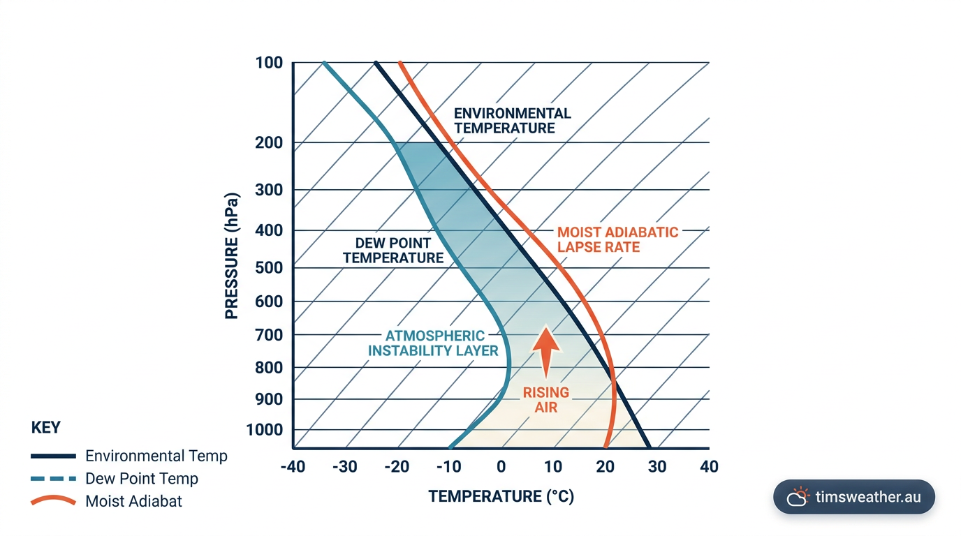
The Bureau’s explainer on how thunderstorms form notes that this release of latent heat is a key part of thunderstorm growth. The slower cooling rate helps the parcel stay warmer than the surrounding air for longer, which supports the strong updraft needed for deep convective clouds and full cumulonimbus development.
Updraft and downdraft in a single-cell storm
The updraft is the rising current that builds the cloud. Once rain and hail form, they drag air downward and create a downdraft. In a single-cell thunderstorm, that downdraft often spreads through the storm base and cuts off the inflow feeding the updraft. When that happens, the storm starts to weaken.
This is why single-cell storms have a short life cycle. The mature stage brings both updraft and downdraft, but the storm cannot separate them for long. Without stronger wind shear to tilt and organise the cell, the storm soon enters the dissipating stage. For a wider look at storm types, see types of severe thunderstorms in Australia.
Why single-cell storms are short-lived
Single-cell thunderstorms usually last less than an hour because they lack the wind shear needed to keep the updraft and downdraft apart. Once the downdraft forms, it brings cooler air to the surface and replaces the warm inflow that was feeding the storm. The cell then weakens, the cloud base shrinks and rainfall tapers off.
In stronger storm setups, wind shear can tilt the storm and prolong the inflow. That is one reason supercells and multicell clusters can last much longer than a single-cell storm. By contrast, a single-cell storm is a compact, local storm with a clear start, peak and fade.
What you may see before and during the storm
If you are outside on a summer afternoon, look for towering convective clouds with darkening bases, rapid vertical growth and a sudden wind shift when the downdraft reaches the ground. Hail, brief heavy rain and lightning can all follow quickly. The sky often looks calm again not long after the storm passes, because the cell has no structure left to sustain it.
Frequently asked questions
Single-cell thunderstorms form when warm, moist air is lifted and becomes unstable, rising into a cumulonimbus cloud. The storm typically goes through one updraft pulse before developing a downdraft as rain falls. This downward flow eventually cuts off the warm air supply, causing the cell to dissipate within an hour.
Further reading and resources
Explore trusted articles, books, videos and other resources to go deeper on this topic.
stratusdeck.co.ukArticle
Single cell thunderstorm
In-depth coverage on How Do Single-Cell Thunderstorms Form? The Complete Meteorological Guide from stratusdeck.co.uk.
weather.govReference
Weather Spotter’s Field Guide - Types of Thunderstorms
Background reference on How Do Single-Cell Thunderstorms Form? The Complete Meteorological Guide from weather.gov.
pilotinstitute.comArticle
Types of Thunderstorms in Aviation: From Simple to Severe
In-depth coverage on How Do Single-Cell Thunderstorms Form? The Complete Meteorological Guide from pilotinstitute.com.
ametsoc.orgArticle
[PDF] Project Atmosphere - American Meteorological Society
In-depth coverage on How Do Single-Cell Thunderstorms Form? The Complete Meteorological Guide from ametsoc.org.
scied.ucar.eduReference
Thunderstorms - UCAR Center for Science Education
Background reference on How Do Single-Cell Thunderstorms Form? The Complete Meteorological Guide from scied.ucar.edu.
pmc.ncbi.nlm.nih.govReference
A comparative study of severe thunderstorm among statistical and ...
Background reference on How Do Single-Cell Thunderstorms Form? The Complete Meteorological Guide from pmc.ncbi.nlm.nih.gov.
saalck.pressbooks.pubArticle
Lab #10: Thunderstorms and Tornadoes
In-depth coverage on How Do Single-Cell Thunderstorms Form? The Complete Meteorological Guide from saalck.pressbooks.pub.
Single Cell/Pulse Thunderstorm Structure and Evolution
Background reference on How Do Single-Cell Thunderstorms Form? The Complete Meteorological Guide from weather.gov.
courses.ems.psu.eduReference
Single-Cell Thunderstorms | METEO 3: Weather Revealed
Background reference on How Do Single-Cell Thunderstorms Form? The Complete Meteorological Guide from courses.ems.psu.edu.
weatherworksinc.comArticle
Single Cell Thunderstorm Life Cycle - WeatherWorks
In-depth coverage on How Do Single-Cell Thunderstorms Form? The Complete Meteorological Guide from weatherworksinc.com.
Planning weeks ahead?
Check Australia's long-range seasonal outlook for rainfall, temperature and the climate drivers (ENSO, IOD, SAM, MJO) shaping the next three months.
View Australia's Seasonal Weather Forecast