
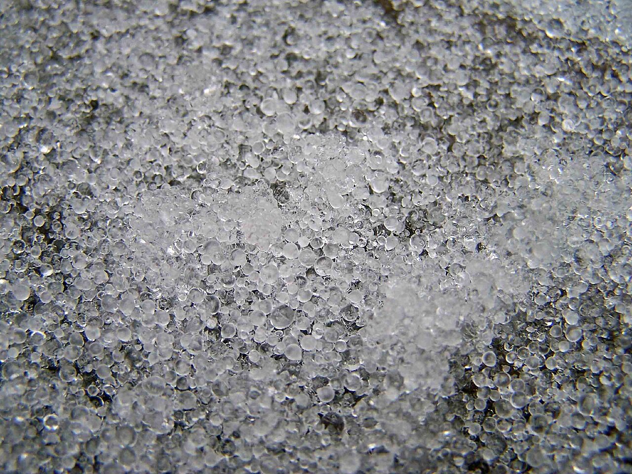
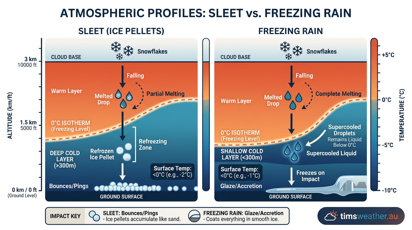
How does sleet form? Sleet forms when snowflakes fall from a cold cloud layer into a warm layer aloft, melting into liquid raindrops. These drops then pass through a deep sub-freezing layer near the surface, causing them to refreeze into solid ice pellets before striking the ground.
Key takeaways
- Sleet requires a specific vertical temperature sequence: sub-freezing air aloft, a middle layer of warm air, and a deep freezing layer at the surface.
- The official meteorological term used by agencies like the World Meteorological Organization for sleet is ice pellets.
- A near-surface cold layer between 600 and 900 metres deep is usually necessary to fully freeze the raindrops before impact.
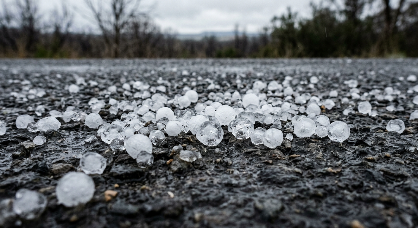
- Sleet bounces when it hits the ground, unlike freezing rain which coats surfaces in a solid sheet of glaze ice.
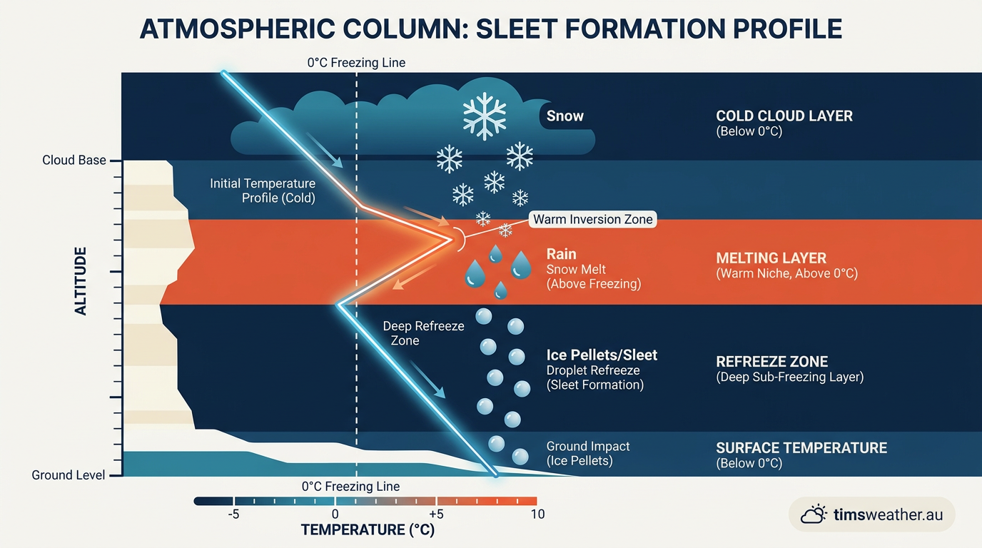
The Atmospheric Temperature Profile for Sleet
How does sleet form compared to other winter precipitation?
The difference between sleet and other forms of winter weather comes down to minor variations in the depth of the warm and cold layers. While sleet, freezing rain, and snow can all occur during the same storm system, they represent completely different hazards and physical states by the time they reach the surface.
Why the depth of the cold layer matters
If the near-surface
How Sleet Pellets are Created in Clouds
The formation of winter precipitation is a continuous process governed by the hydrological cycle and atmospheric thermodynamics. While many people associate frozen precipitation with severe convective storms and hail, the mechanics of how do cumulonimbus clouds form are generally separate from sleet events. Sleet typically falls from widespread, stratiform cloud decks, such as nimbostratus or thick altostratus layers, associated with large-scale synoptic weather systems.
The Thermodynamic Lifecycle of an Ice Pellet
The thermodynamic lifecycle of an ice pellet involves two distinct phase changes. First, as the snowflake enters the warm layer, thermal energy from the surrounding air transfers to the ice crystal. The delicate, branched structure of the snowflake melts from the outside in, collapsing into a spherical water droplet due to surface tension. The depth of the cloud layer and the temperature gradients within it significantly affect the eventual intensity and size of the precipitation (www.youtube.com).
Second, as the spherical drop falls into the deep near-surface cold layer, it begins to lose thermal energy rapidly. The exterior of the droplet freezes first, forming a hard shell of ice. As the inner core of liquid water continues to freeze, it expands. This expansion within the frozen shell is why ice pellets often have tiny structural fractures or irregular bulges when examined closely. By the time they strike the earth, they are hard, translucent spheres of ice, typically less than 5 millimetres in diameter.
Meteorological Terminology: Ice Pellets and Frozen Precipitation
While the general public uses the term sleet, international meteorological standards maintain strict definitions to avoid confusion across different climate regimes. The World Meteorological Organization officially classifies this precipitation as ice pellets, distinguishing it entirely from snow, hail, and freezing rain. In formal snowfall observing practices, national forecasting agencies count snow, ice pellets, snow pellets, snow grains, and ice crystals as frozen precipitation, measuring their physical accumulation on the ground (www.facebook.com).
Distinguishing Sleet from Freezing Rain: A Vertical Profile Analysis
Meteorology relies on vertical profile measurements to predict which type of precipitation will reach the ground. Weather balloons, known as radiosondes, are launched twice daily worldwide to measure temperature and humidity as they ascend through the troposphere. The resulting data is plotted on specialised thermodynamic diagrams called Skew-T Log-P charts.
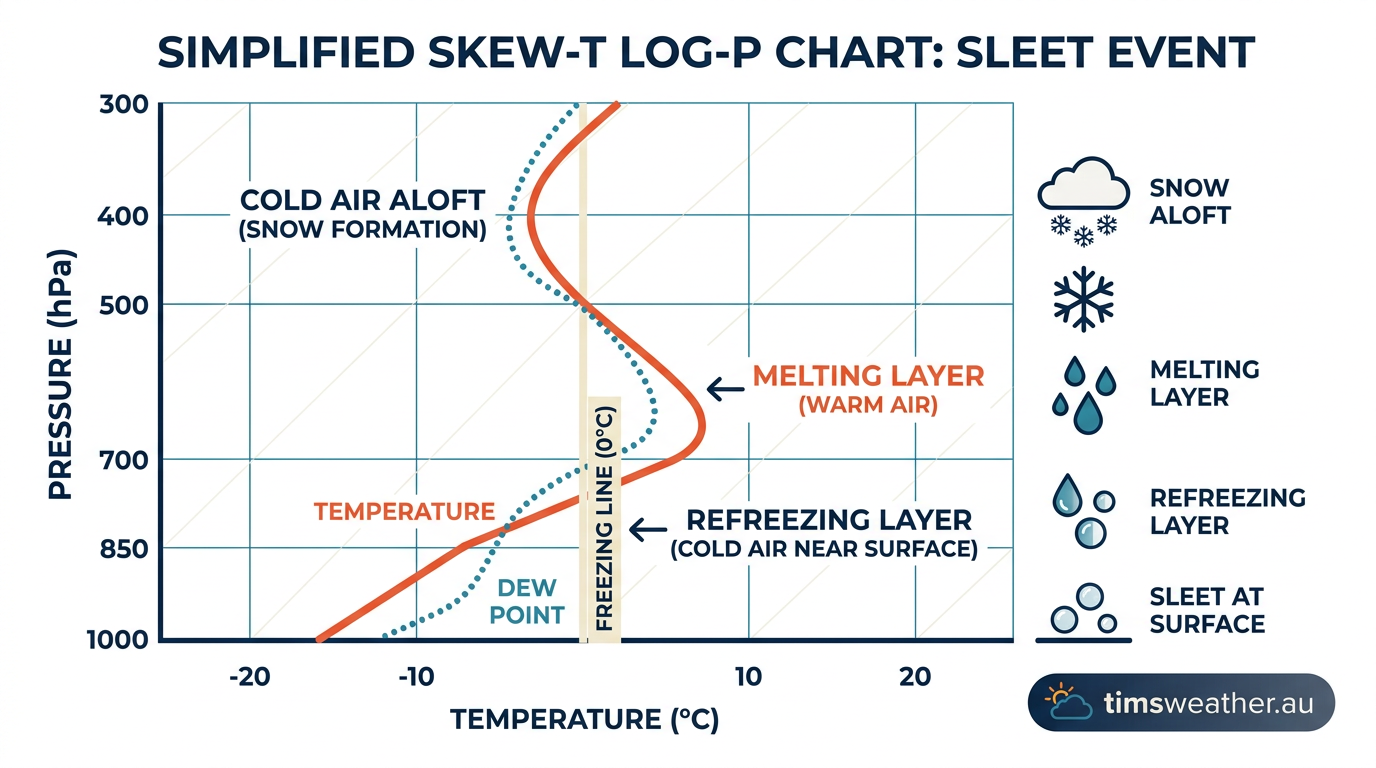
When forecasting sleet, meteorologists look for a specific signature on the Skew-T chart. The environmental temperature line must start above the freezing level (0°C) near the surface, cross to the left of the freezing line in the lower boundary layer (indicating the deep cold layer), cross to the right into a "warm nose" aloft, and finally cross back to the left in the upper atmosphere where snowflakes form. Calculating the area and depth of the warm and cold zones on these charts allows forecasting models to determine whether the latent heat transfer will result in partial or total refreezing.
Why Does Sleet Fall in Winter?
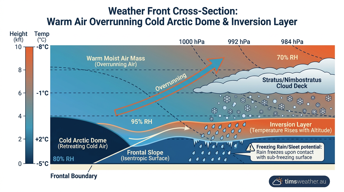
Sleet is fundamentally a winter weather phenomenon because it requires a cold surface environment combined with a specific overrunning weather pattern. How how do cold fronts form and move helps explain why sleet is common in certain climates. Frequently, sleet occurs when a shallow mass of dense, arctic air pushes southward near the surface, while a warmer, moist air mass overrides it aloft.
Why Atmospheric Inversions are Critical for Sleet Formation
This dynamic overrunning creates a strong inversion layer. Normally, warm air rises and cold air sinks, but in an overrunning winter setup, the dense cold air is trapped at the surface, physically wedging under the advancing warm air. As the warm, moist air is forced upwards over the cold dome, it cools and condenses, a process similar to altostratus clouds formation. Precipitation falls from this upper layer, passes through the warm sector, and then plunges into the trapped cold air mass below. Without this strong thermal inversion trapping cold air at the surface, the precipitation would simply fall as standard rain or snow.
Is Sleet Dangerous for Driving?
Winter storms often bring a complex mixture of precipitation types, and the transition from one phase to another can drastically alter road conditions. A storm may begin with snow, transition to sleet, and eventually turn into freezing rain as the warm layer aloft thickens and the surface cold layer becomes too shallow (www.fox5dc.com).
Impact of Surface Temperatures on Sleet Accumulation Rates
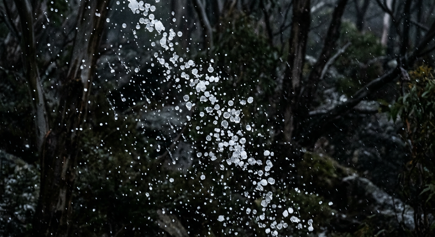
Because sleet consists of frozen, hard pellets, it behaves differently upon impact than other precipitation. It bounces off vehicles, windshields, and roads, producing a distinct tapping sound. On the ground, it accumulates much like dry sand or small gravel. While it does not instantly coat surfaces in a solid sheet of glaze ice, heavy sleet accumulation remains extremely hazardous for driving. The loose pellets act like ball bearings under tyres, severely reducing traction and increasing stopping distances.
However, when compared to the broader hazard profile of winter weather, sleet is generally considered less destructive to infrastructure than freezing rain. Because sleet is already frozen, it does not cling to power lines or tree branches. Freezing rain, by contrast, can accumulate thick, heavy layers of solid ice that bring down power grids and cause widespread structural damage. If you are tracking a winter storm, understanding the mechanics of how do low-pressure systems form and draw in varying air masses will help you anticipate whether the precipitation will bounce as harmless ice pellets or freeze as dangerous glaze ice.
Sources
- Bureau of Meteorology weather reference (bom.gov.au)
- NOAA weather and atmospheric science reference (nssl.noaa.gov)
- NOAA weather and atmospheric science reference (goes-r.noaa.gov)
- NOAA weather and atmospheric science reference (nssl.noaa.gov)
- Snow: your questions answered - Social Media Blog (media.bom.gov.au)
- What Makes It Rain? (nesdis.noaa.gov)
- NOAA weather and atmospheric science reference (repository.library.noaa.gov)
- Explanatory remarks | International Cloud Atlas (cloudatlas.wmo.int)
Last verified: 2026-09-12
Frequently asked questions
Sleet forms when snowflakes fall through a layer of warm air and melt into raindrops. As these drops continue to fall, they enter a deeper layer of freezing air near the ground. This causes the water to refreeze into small, translucent ice pellets before they hit the surface.
Source: bom.gov.au
Further reading and resources
Explore trusted articles, books, videos and other resources to go deeper on this topic.
education.nationalgeographic.orgArticle
Sleet - National Geographic Education
In-depth coverage on How Does Sleet Form? The Science of Ice Pellets and Winter Precipitation from education.nationalgeographic.org.
weather.govReference
What is the Difference between Sleet, Freezing Rain, and Snow?
Background reference on How Does Sleet Form? The Science of Ice Pellets and Winter Precipitation from weather.gov.
Winter Wx
Background reference on How Does Sleet Form? The Science of Ice Pellets and Winter Precipitation from weather.gov.
youtube.comVideo
What causes sleet or freezing rain to form - YouTube
Video coverage on How Does Sleet Form? The Science of Ice Pellets and Winter Precipitation from youtube.com.
Winter Weather Terms
Background reference on How Does Sleet Form? The Science of Ice Pellets and Winter Precipitation from weather.gov.
popsci.comArticle
The most dangerous type of precipitation isn't snow
In-depth coverage on How Does Sleet Form? The Science of Ice Pellets and Winter Precipitation from popsci.com.
extension.illinois.eduReference
What's the difference between snow, sleet, and freezing rain? |
Background reference on How Does Sleet Form? The Science of Ice Pellets and Winter Precipitation from extension.illinois.edu.
mprnews.orgArticle
Rain, sleet or snow? Why winter storms can be so confusing
In-depth coverage on How Does Sleet Form? The Science of Ice Pellets and Winter Precipitation from mprnews.org.
nsidc.orgArticle
Science of Snow | National Snow and Ice Data Center
In-depth coverage on How Does Sleet Form? The Science of Ice Pellets and Winter Precipitation from nsidc.org.
cbsnews.comArticle
Snow, sleet, rain or freezing rain? Breaking down four types of ...
In-depth coverage on How Does Sleet Form? The Science of Ice Pellets and Winter Precipitation from cbsnews.com.
Planning weeks ahead?
Check Australia's long-range seasonal outlook for rainfall, temperature and the climate drivers (ENSO, IOD, SAM, MJO) shaping the next three months.
View Australia's Seasonal Weather Forecast