
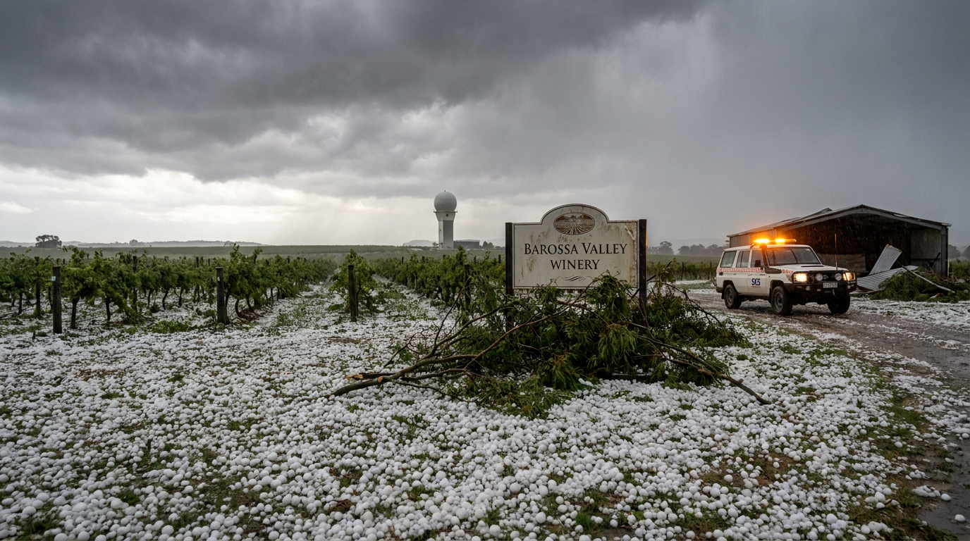
The October 2021 Adelaide hailstorm struck on 28 October and brought severe hail, strong winds and heavy rain to parts of South Australia. It affected metropolitan Adelaide, the Adelaide Hills and the Barossa Valley, with damage reported to homes, vehicles and crops. The event also led to a major insurance response and a large workload for emergency services.
Key takeaways
- The storm involved a South Australian supercell and other severe thunderstorms that produced giant hail.
- The BOM severe weather warning gave residents time to move cars, secure property and shelter indoors.
- The South Australian State Emergency Service (SES) received a large number of callouts for roof damage, broken skylights and water ingress.
- The Insurance Council of Australia declared the event a catastrophic insurance event, with early estimates of about $100 million in damage and about 12,000 claims.
- The Mount Lofty Ranges helped lift moist air and keep the storms strong as they moved inland.
October 2021 Adelaide hailstorm overview
The storm formed during spring, when South Australia can see warm, moist air meet stronger southerly change lines. That setup can make the atmosphere unstable, which helps severe thunderstorms grow. In this case, the Bureau of Meteorology (BOM) warned of severe thunderstorms for the Adelaide area, and the storms that followed were powerful enough to cause widespread hail damage.
What happened during the hailstorm?
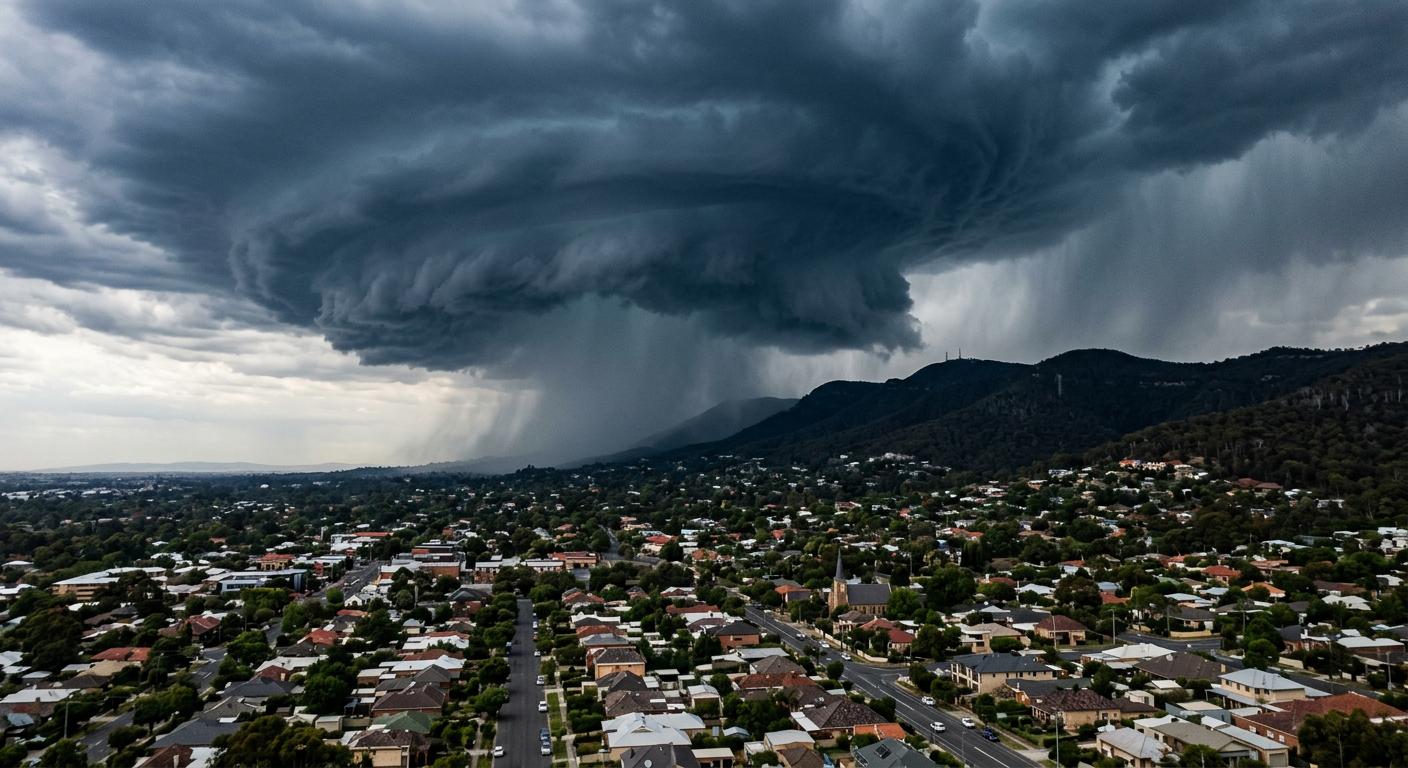
The October 2021 Adelaide hailstorm brought severe thunderstorms across South Australia on 28 October. Research sources describe damaging hail in the Adelaide area, with golf ball-sized hail reported in some places. The storm affected homes, cars and crops, and it was later described as an insurance catastrophe because of the scale of the losses and the number of claims.
Many people in the Adelaide Hills heard the storm before they saw it. That loud, rushing sound often comes from a hail core and strong inflow around a severe storm. It is a sign that the storm is producing intense updrafts and heavy ice loading.
Why the storm became so severe
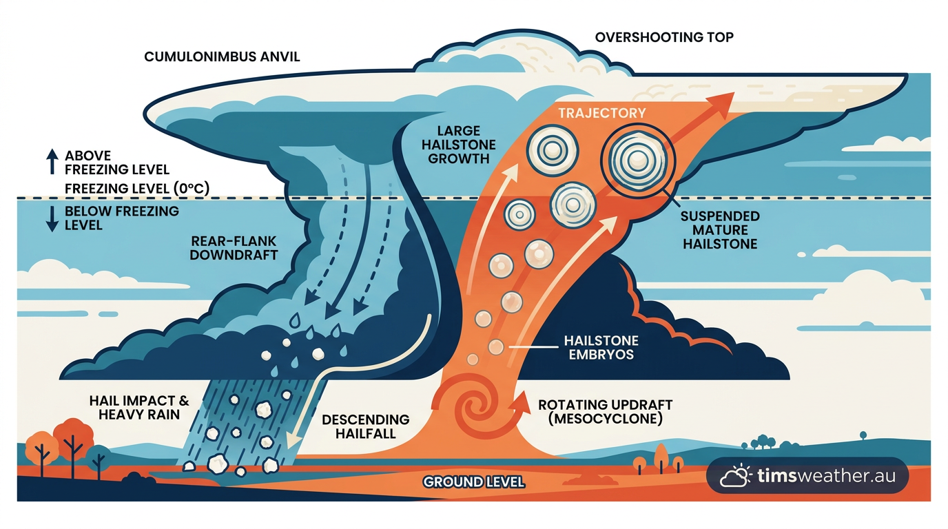
The main ingredients were instability, moisture and wind shear. When the air near the ground is warm and humid, and winds change speed or direction with height, thunderstorms can organise into long-lived storm cells. A supercell thunderstorm has a rotating updraft, called a mesocyclone, which helps it keep growing instead of collapsing quickly.
The Mount Lofty Ranges also mattered. As the storm moved inland, the terrain forced air to rise. That orographic lift helped feed the storm with more uplift and moisture, which supported thunderstorm intensity over the ranges and nearby districts.
For readers who want the basics of storm structure, see our guide on supercell thunderstorms in Australia. For how storms form more generally, see how thunderstorms form.
Damage across Adelaide, the Hills and the Barossa
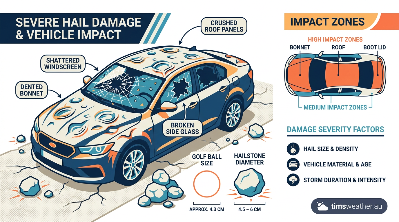
The biggest losses came from giant hail damage. Hail broke roof materials, damaged skylights and smashed windows. Cars parked outdoors were also heavily dented, which created long repair queues across South Australia.
The Adelaide Hills and the Barossa Valley were among the hardest-hit areas in the research bundle. In farming districts, hail damaged grapes and other crops just as the growing season was building. For growers, a short storm can cut through months of work in minutes.
The scale of the repair task turned the event into a major local recovery job. Emergency services helped with temporary roof coverings, fallen branches and other urgent clean-up work, while households waited for insurance assessments and repair bookings.
SES emergency callouts and emergency services response
The South Australian State Emergency Service (SES) received many callouts after the storm. The main problems were leaking roofs, damaged gutters, broken windows and water entering homes and businesses. Emergency services focused on reducing further damage rather than trying to repair everything at once.
That response matters because hail damage often keeps getting worse after the storm passes. Once a roof is punctured or a window is broken, even a short burst of rain can send water into ceilings, walls and flooring. If you are dealing with active severe weather, stay inside and follow current BOM warnings.
Insurance impact and recovery
The Insurance Council of Australia declared the hailstorm a catastrophic insurance event. News reports in the research bundle place initial damage at about $100 million, with around 12,000 claims made soon after the event. Another industry estimate for the broader late-October storm sequence in southern Australia was A$1.03 billion in insured losses, but that figure covers a wider period than this single hailstorm.
This is why the event is often discussed as a major insurance shock, not just a local storm. Large numbers of damaged vehicles, roofs and crops can overwhelm assessors, repairers and claims teams very quickly.
Recovery took time. Car repair queues grew, roofers were stretched and some households waited a long time for final repairs. That lag is common after a large hail event because the damage is spread across a wide area and the repair work is specialised.
What the storm says about Australian hailstorm frequency
Australian hailstorm frequency varies from year to year, but spring often brings the right ingredients for severe hail in southern Australia. South Australia, Victoria and New South Wales can all see dangerous storms when warm inland air meets stronger upper-level winds.
The October 2021 Adelaide hailstorm is a reminder that a single afternoon can cause major losses when a severe storm tracks over a dense urban area. It also shows why BOM warnings, local shelter plans and quick action to move vehicles matter.
On climate change attribution, the research bundle does not include an event-specific study for this hailstorm, so it is not possible to say from these sources whether climate change changed the odds or intensity of this particular event. That is a separate scientific question and needs a formal attribution study.
What to do during a severe hail warning
If BOM issues a severe weather warning for hail or damaging storms, act early:
- Move cars under cover if you can do so safely.
- Bring pets and livestock into shelter where possible.
- Close windows and secure loose outdoor items.
- Stay away from skylights and glass doors during the storm.
- Check updates from BOM and your local emergency service.
After the storm, photograph damage before you start clean-up, then contact your insurer and the SES if you need urgent help.
Frequently asked questions
A severe supercell thunderstorm formed over the Adelaide region, triggered by the combination of warm, moist air and strong wind shear. These conditions allowed a powerful rotating storm to develop, which produced very large hail, damaging winds, and heavy rainfall as it moved across the metropolitan area and hills.
Source: bom.gov.au
Further reading and resources
Explore trusted articles, books, videos and other resources to go deeper on this topic.
riskfrontiers.comArticle
Kicking Off Storm Season
In-depth coverage on October 2021 Adelaide Hailstorm: Supercells, Damage and Insurance Impact from riskfrontiers.com.
dentrevolution.com.auArticle
Adelaide October 2021 Hailstorm Throws Huge Amounts of ...
In-depth coverage on October 2021 Adelaide Hailstorm: Supercells, Damage and Insurance Impact from dentrevolution.com.au.
knowledge.aidr.org.auArticle
Storm - South Australia, October 2021 | Australian Disaster ...
In-depth coverage on October 2021 Adelaide Hailstorm: Supercells, Damage and Insurance Impact from knowledge.aidr.org.au.
insurancecouncil.com.auArticle
Insurance Catastrophe declared for SA severe storms
In-depth coverage on October 2021 Adelaide Hailstorm: Supercells, Damage and Insurance Impact from insurancecouncil.com.au.
perils.orgArticle
perils puts initial industry loss estimate for october 2021 ...
In-depth coverage on October 2021 Adelaide Hailstorm: Supercells, Damage and Insurance Impact from perils.org.
insurancejournal.comArticle
Insurance Losses for October Storms in Southern Australia ...
In-depth coverage on October 2021 Adelaide Hailstorm: Supercells, Damage and Insurance Impact from insurancejournal.com.
Planning weeks ahead?
Check Australia's long-range seasonal outlook for rainfall, temperature and the climate drivers (ENSO, IOD, SAM, MJO) shaping the next three months.
View Australia's Seasonal Weather Forecast