
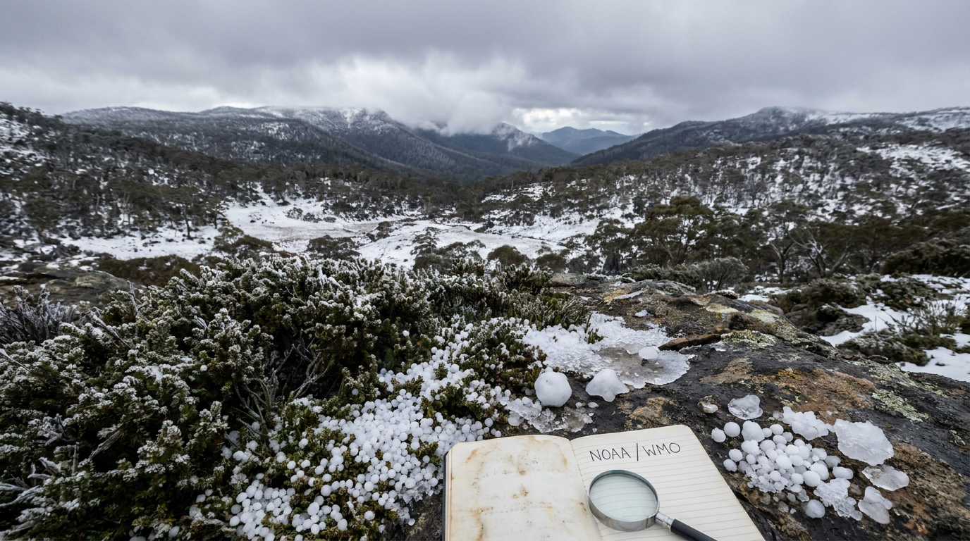
If you are wondering what is graupel, it is a type of frozen precipitation that forms when supercooled water droplets freeze directly onto falling snowflakes. This meteorological process, known as riming, creates white, opaque particles often called snow pellets or soft hail, distinct from both standard snow and solid hailstones.
Key takeaways
- Graupel forms via the accretion process, where liquid water below freezing temperature instantly solidifies upon contact with a descending ice crystal.
- International meteorological standards classify these soft, crushable hydrometeors under 5 mm in diameter as snow pellets rather than true hail.
- Unlike sleet, which consists of melted and completely refrozen raindrops, this phenomenon never passes through a warm melting layer during its descent.
- The presence of these opaque pellets at the surface serves as a reliable indicator of steep temperature gradients and atmospheric instability.
What is graupel?
Graupel is a form of frozen precipitation that forms when supercooled water droplets freeze onto falling snowflakes through a process called riming. Unlike hail, which forms in intense thunderstorms with strong updrafts, graupel is soft, opaque, and easily crumbles, often occurring during cold-season convective showers rather than summer storms.
The Micro-Physics Behind the Riming Process
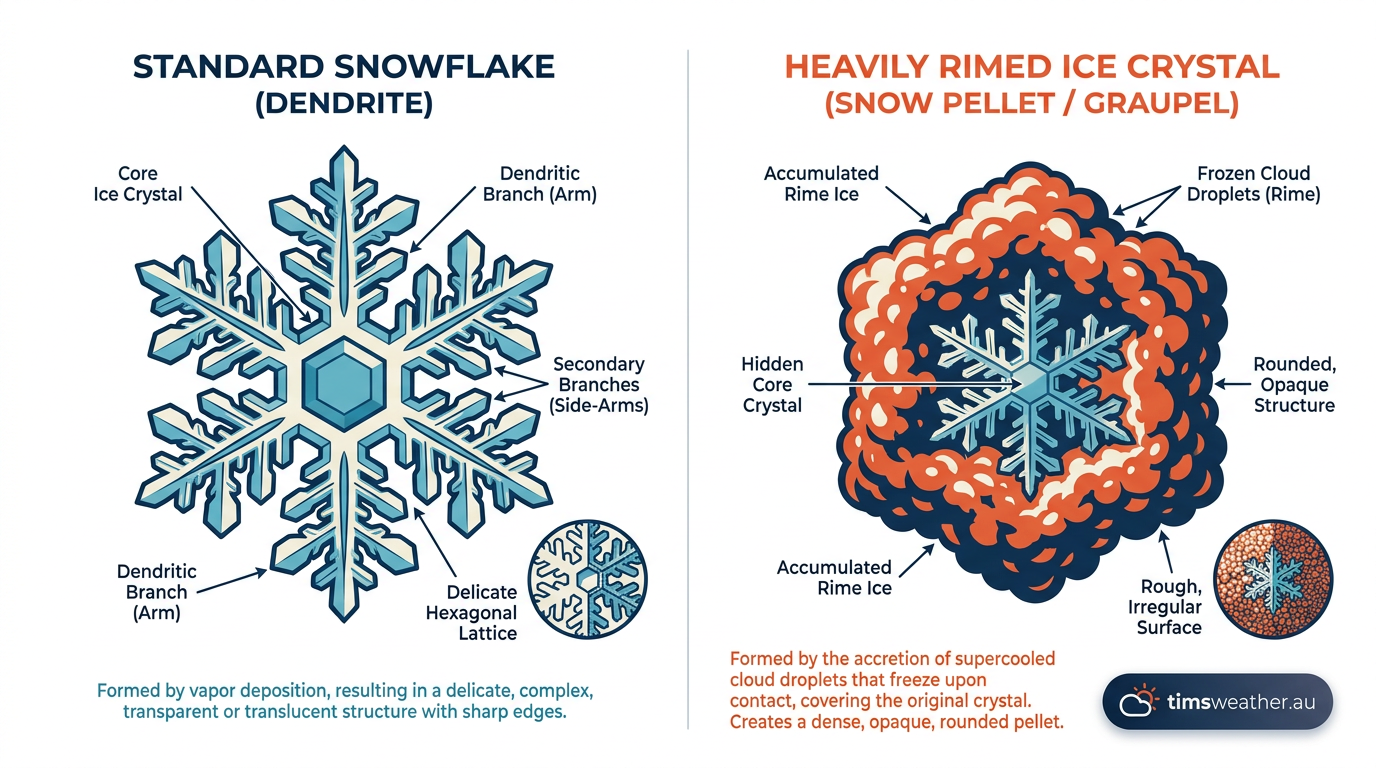
Riming begins with supercooled cloud droplets, which are liquid water droplets that persist at temperatures below 0°C because they have nothing to freeze onto. When a falling ice crystal sweeps through a cloud layer full of these droplets, each droplet that strikes the crystal freezes almost instantly on contact.
Repeat that collision thousands of times and the delicate arms of the original snowflake disappear beneath a thickening crust of frozen droplets. The finished pellet is white and opaque rather than clear, because the rapid freezing traps countless air pockets between the rime layers. Most pellets end up between 2 mm and 5 mm across, with a density far lower than solid ice, which is why they crush between your fingers instead of bouncing.
The process needs a deep layer of cloud that is entirely below freezing, modest lift rather than a violent updraught, and a plentiful supply of supercooled water. In Australia that combination is most common behind a vigorous cold front or under an upper-level trough during the cooler months, which is why alpine areas such as the Snowy Mountains, the Victorian Alps and the Tasmanian highlands see it most often, along with occasional falls on the elevated tablelands of New South Wales.
Graupel vs Hail: Understanding the Key Differences
Both are ice falling from a cloud, but they are built in very different places. Graupel grows in gentle, shallow convection where the whole cloud is below freezing, so each pellet takes a single trip down through a supercooled layer. Hail grows in the powerful updraught of a thunderstorm, where a stone can be carried up and down repeatedly, gaining a new layer of clear ice on every pass.
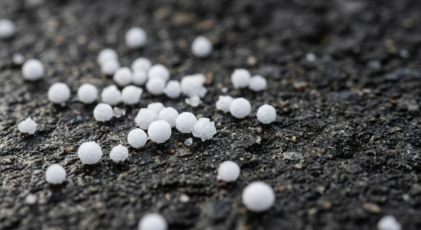
That difference shows up in the hand. Graupel is white, opaque, soft and crumbles under light pressure, and by international convention it stays under 5 mm across. A hailstone is hard and often layered like an onion when cut open, frequently exceeds 5 mm, and in severe Australian storms can reach golf ball size or larger. Graupel patters softly and settles like polystyrene beads; hail cracks, bounces and damages roofs, cars and crops.
Timing separates them too. Hail is a warm-season hazard, arriving with the spring and summer supercells that affect south-east Queensland, inland and coastal New South Wales, and parts of Victoria and the south-west of Western Australia. Graupel belongs to the cold season, turning up in winter showers and alpine snow events when the freezing level drops close to the surface. If soft white pellets are falling on a cold, showery July afternoon, you are almost certainly looking at graupel rather than hail.
Graupel vs. Sleet: Resolving the Most Common Misconception
Many news outlets and casual observers use the terms graupel and sleet interchangeably. This is an understandable error, as both appear as tiny balls of ice falling during winter weather events. However, distinguishing between these frozen precipitation types requires recognizing two entirely different atmospheric temperature profiles.
How how does sleet form involves identifying a specific mid-level temperature inversion. Sleet, officially termed ice pellets in many regions, begins its journey as snow high in the atmosphere. As it falls, it encounters a layer of warm air where temperatures exceed 0°C. The snowflake melts completely into a liquid raindrop. It then continues its descent, passing through a deep, sub-freezing layer of air near the surface. The raindrop refreezes into a solid, translucent ball of ice before hitting the ground. Sleet is clear, hard, and audibly bounces when it strikes a window or pavement.
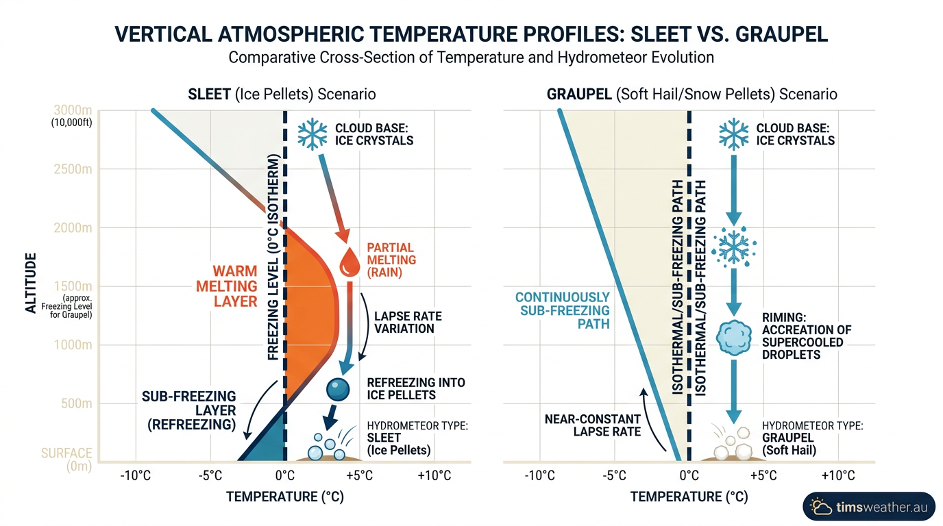
Graupel follows a completely different thermal path. It never experiences a melting phase. The entire atmospheric column, from the cloud base to the surface, remains below freezing. The particle grows purely by accumulating supercooled water droplets through riming. Because it never melts and refreezes, it remains opaque, white, and soft.
Meteorologists use specific atmospheric sounding profiles, plotted on complex charts, to forecast which type of precipitation will reach the ground. As explained by the National Weather Service, a sleet skew-T profile displays a distinct warm nose where the environmental temperature line sharply crosses to the right of the freezing line in the mid-levels. A graupel skew-T profile shows the temperature line staying entirely to the left of the freezing line, but with a steep environmental lapse rate that supports convective instability and the upward transport of moisture.
The Life Cycle of a Snow Pellet
The journey from a microscopic ice nucleus to a falling snow pellet is a continuous display of dynamic cloud physics. The life cycle begins in the upper reaches of a developing cloud, where temperatures hover between -10°C and -20°C. Here, water vapor deposits directly onto freezing nuclei to create the initial ice crystal structure.
As the cloud thickens and vertical motion increases, the accretion phase begins. The crystal sweeps up supercooled droplets, heavily riming its delicate edges. This accumulation adds significant mass. In atmospheric physics, as a hydrometeor gains mass, its terminal velocity increases. The heavier the particle becomes, the faster it falls, allowing it to overtake even more droplets and grow at an accelerating rate.
The final fate of this particle depends entirely on the storm environment. The National Oceanic and Atmospheric Administration highlights that graupel frequently acts as the primary hail embryo in severe weather. If the snow pellet is caught in the massive updraft of single-cell thunderstorms during summer, it is carried upward to accumulate thick layers of dense ice, eventually becoming a large hailstone.
During the colder months, however, the updrafts are shallow. The snow pellet reaches an equilibrium point where its terminal velocity overcomes the weak upward wind, causing it to fall out of the cloud base. It descends rapidly as soft hail, reaching the ground completely intact as long as the surface temperature remains relatively cool.
Why Graupel Indicates Atmospheric Instability
The specific types of precipitation that fall from a cloud communicate clear signals about the invisible vertical structure of the atmosphere. Gentle, steady snow grains or flakes typically indicate a stable atmosphere where air is rising slowly and uniformly over a broad area. When snow pellets reach the ground, they tell a much more turbulent story.
The presence of these hydrometeors confirms strong convective currents and steep temperature gradients. This instability occurs when exceptionally cold air aloft moves over a relatively warm surface. The warmer air at the surface is less dense, causing it to rise rapidly into the colder layer above. This vigorous overturning forces moisture upward, generating shallow but intense convective precipitation cells. These conditions are highly common behind strong cold fronts or when cold air moves over warmer bodies of water, similar to the initial stages of lake-effect snow.
Regional Impacts: Why Graupel Triggers False Winter Storm Warnings
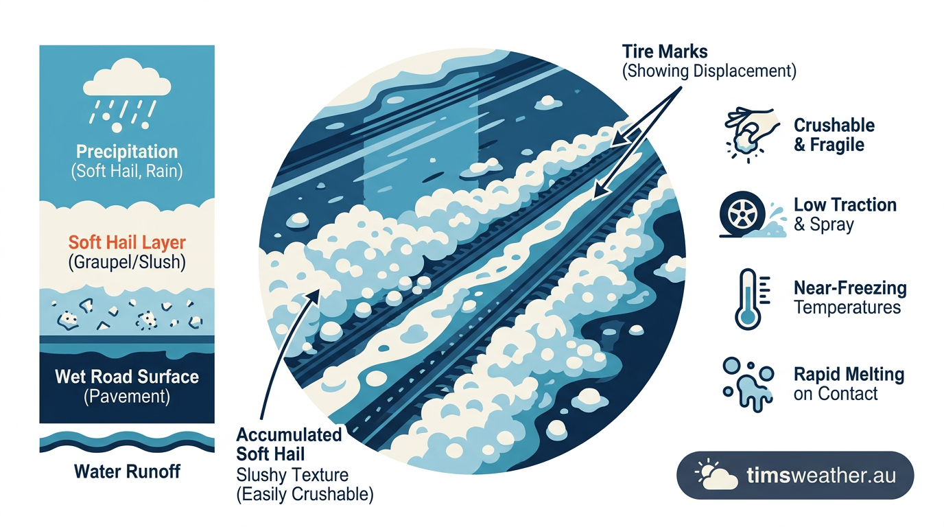
Because soft hail falls rapidly in intense, localized bursts, it can coat roads and lawns in brilliant white within minutes. To the general public, this sudden accumulation strongly mimics the onset of a severe snowstorm. This visual similarity frequently leads to widespread public confusion, panicked travel adjustments, and false reports of heavy snow.
Meteorologists take this distinction seriously. The official National Weather Service glossary explicitly require trained spotters to report snow pellets separately from traditional snow, as the two represent completely different meteorological events. Snow pellets are brittle and act like thousands of tiny ball bearings on pavement, creating sudden, unexpected slick spots for drivers.
Because these winter convective showers are highly localized and tied to specific, transient cells, they often fall between the grids of broad regional forecast models. They cause brief but intense travel disruptions, only to melt away swiftly without generating the sustained, widespread impacts of a true winter storm system.
Comparing Frozen Precipitation Types
A clear, side-by-side assessment helps observers quickly differentiate these various hydrometeors during a complex winter weather event. The Met Office and other international agencies emphasize that noting the physical texture and observing the surrounding atmospheric context are the most reliable ways to identify what is falling from the sky.
| Phenomenon | Formation Process | Texture | Atmospheric Context |
|---|---|---|---|
| Snow | Water vapor deposits directly onto ice crystals | Light, flaky, detailed crystalline structures | Stable atmosphere with gentle, uniform lifting |
| Graupel | Supercooled liquid droplets freeze onto falling snow | Opaque white, soft, easily crushed | Steep temperature gradients and winter instability |
| Sleet | Snowflakes completely melt, then refreeze into ice | Translucent, hard, bounces on impact | Warm layer aloft overlaying a deep sub-freezing surface layer |
| Hail | Multiple cycles of accretion in extreme updrafts | Hard, solid, dense, often containing clear ice layers | Severe thunderstorms and massive cumulonimbus clouds |
Accurate identification goes beyond simple curiosity. Recognizing the distinct properties of snow pellets helps meteorological agencies refine their short-term forecasting, allowing them to issue precise warnings for sudden slick roads and unstable air masses rather than issuing broad, inaccurate snow advisories.
Sources
- NOAA weather and atmospheric science reference (repository.library.noaa.gov)
- NOAA weather and atmospheric science reference (repository.library.noaa.gov)
- NOAA weather and atmospheric science reference (repository.library.noaa.gov)
- NOAA weather and atmospheric science reference (repository.library.noaa.gov)
- NOAA weather and atmospheric science reference (vlab.noaa.gov)
- NOAA weather and atmospheric science reference (repository.library.noaa.gov)
- NOAA weather and atmospheric science reference (nssl.noaa.gov)
- NOAA weather and atmospheric science reference (repository.library.noaa.gov)
Last verified: 2026-09-22
Frequently asked questions
Graupel is a type of frozen precipitation that forms when supercooled water droplets freeze onto falling snow crystals. Often referred to as snow pellets or soft hail, these white, opaque particles form in cold, unstable weather conditions, appearing distinct from both regular snowflakes and hard, icy hail pellets.
Source: weather.com
Further reading and resources
Explore trusted articles, books, videos and other resources to go deeper on this topic.
science.howstuffworks.comArticle
Graupel Isn't Snow, Nor Sleet, Nor Hail, So What the Heck Is It?
In-depth coverage on Graupel Isn't Hail and It Isn't Snow — Learn to Tell Them Apart from science.howstuffworks.com.
youtube.comVideo
Hail vs. graupel: Explainer from Chief Meteorologist Tom Wachs - YouTube
Video coverage on Graupel Isn't Hail and It Isn't Snow — Learn to Tell Them Apart from youtube.com.
How to know the difference between graupel, hail and snow - YouTube
Video coverage on Graupel Isn't Hail and It Isn't Snow — Learn to Tell Them Apart from youtube.com.
sky-lights.orgArticle
Q&A: Graupel - SKY LIGHTS
In-depth coverage on Graupel Isn't Hail and It Isn't Snow — Learn to Tell Them Apart from sky-lights.org.
en.wikipedia.orgReference
Graupel - Wikipedia
Background reference on Graupel Isn't Hail and It Isn't Snow — Learn to Tell Them Apart from en.wikipedia.org.
accuweather.comArticle
What is graupel? How it is different from sleet or hail? - AccuWeather
In-depth coverage on Graupel Isn't Hail and It Isn't Snow — Learn to Tell Them Apart from accuweather.com.
Planning weeks ahead?
Check Australia's long-range seasonal outlook for rainfall, temperature and the climate drivers (ENSO, IOD, SAM, MJO) shaping the next three months.
View Australia's Seasonal Weather Forecast