
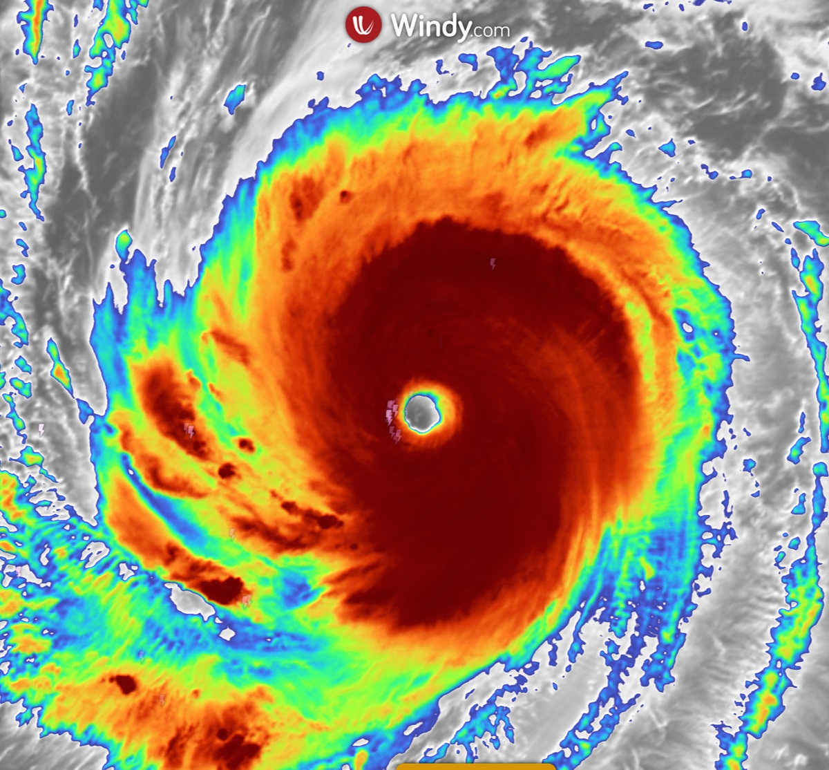
An eyewall replacement cycle is a process in intense tropical cyclones where a secondary outer eyewall forms, contracts inward, and replaces the original inner eyewall. This structural change usually causes a temporary period of weakening, followed by a broader wind field and potential re-intensification.
Key takeaways
Intense cyclones often develop concentric eyewalls during their mature stage as outer rainbands organise into a new convective ring.
The formation of an outer eyewall chokes the inner core of moisture, triggering a temporary drop in peak maximum sustained winds.
Once the inner eyewall collapses, the storm typically features a much larger eye and a significantly expanded wind field.
An expanded wind field increases the risk of severe storm surge across a wider stretch of coastline.
Forecasters rely on microwave satellite imagery to detect these internal structural changes before they become visible on standard infrared images.
How eyewall replacement cycles affect cyclone intensity
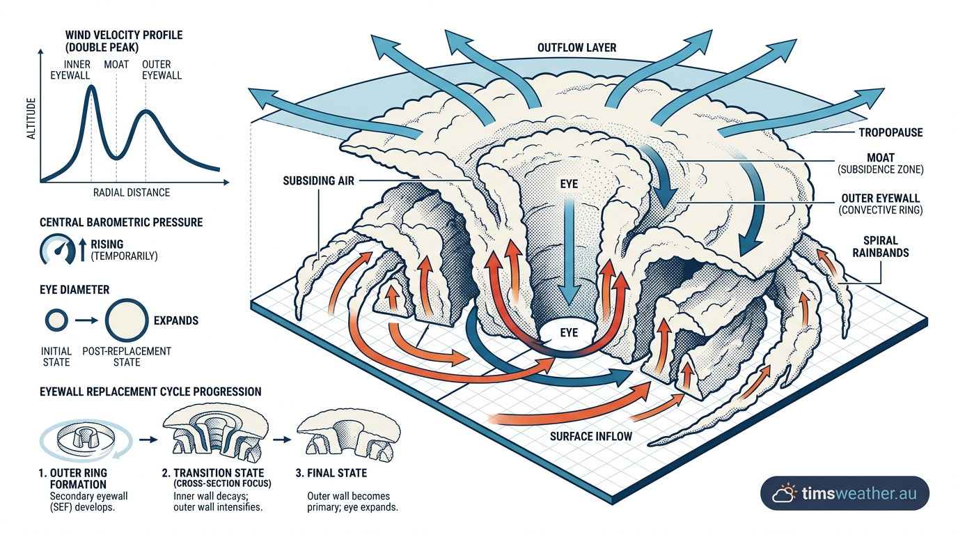
Cross-section diagram illustrating the mechanics of an eyewall replacement cycle with inner and outer concentric eyewalls.
To understand the mechanics of an eyewall replacement cycle, you first need to look at how a mature tropical cyclone is structured. The most destructive winds in any cyclone are found in the eyewall, which is the thick ring of deep thunderstorms immediately surrounding the calm central eye. When a system reaches a high intensity, the internal dynamics often become unstable. As meteorologists at the NOAA Atlantic Oceanographic and Meteorological Laboratory note, these cycles typically begin in the mature stage of strong storms when the inner eye is very small, sometimes just 10 to 25 kilometres across.
The outer eyewall formation
The cycle begins when outer rainbands start to organise into a distinct secondary ring of thunderstorms. This creates a double eyewall structure, often referred to as concentric eyewalls. At this stage, the storm is actively consuming massive amounts of energy from the ocean surface. The newly formed outer eyewall requires its own supply of thermal energy to sustain its massive updrafts. To get this energy, the outer ring begins to intercept the inflow of warm, moist air near the ocean surface before that moisture convergence can reach the inner core.
Video of an eyewall replacement cyclone
Moisture convergence and latent heat release
As the secondary eyewall grows, it acts as a physical barrier. The powerful updrafts in this outer ring pull the incoming marine boundary layer air upwards. Because this moisture convergence is happening 30 to 60 kilometres away from the absolute centre, the original inner eyewall is starved of the latent heat release it needs to survive. The outer thunderstorms are effectively stealing the fuel that previously powered the core of the cyclone.
The inner eyewall collapse
As the outer eyewall strengthens, a clear moat region develops between the two concentric eyewalls. Inside this moat, air is forced downwards in a process called subsidence. This sinking air suppresses any new thunderstorm development and completely cuts off the inward flow of angular momentum. Deprived of its fuel, the inner eyewall decays and eventually collapses. During this transition, the storm's central pressure often rises slightly, and the peak wind speeds drop.
The stadium effect and vortex breakdown
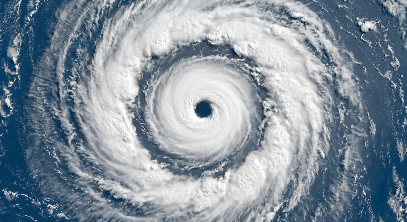
Satellite view of a tropical cyclone displaying a double eyewall structure during an eyewall replacement cycle.
The structure of a strong cyclone eye often resembles a sports stadium, sloping outwards as altitude increases. This is known as the stadium effect. Recent peer-reviewed studies on vortex breakdown show that when an outer eyewall forms, it disrupts this delicate stadium structure. The new outer wall builds its own towering stadium shape, which mechanically forces the inner vortex to break down. This complex fluid dynamic process explains why natural fluctuations in intensity are almost guaranteed in severe Category 4 and Category 5 systems.
Stages of a tropical cyclone eyewall replacement
The progression of an eyewall replacement cycle follows a distinct, measurable pattern that Tropical Cyclone Warning Centres (TCWC) monitor closely. Tracking these stages helps emergency managers prepare coastal zones for fluctuating impacts.
ERC Phase | Structural Change | Intensity Impact | Wind Field Width |
|---|---|---|---|
1. Organisation | Outer rainbands form a secondary convective ring. | Intensification pauses or slows down. | Remains stable. |
2. Concentric Eyewalls | Both inner and outer eyewalls are visible. | Peak winds begin to drop slightly. | Initial expansion begins. |
3. Inner Collapse | Inner eyewall degrades due to moisture starvation. | Storm reaches its weakest point during the cycle. | Significant expansion. |
4. Outer Contraction | New single eyewall contracts towards the centre. | System stabilises and may re-intensify. | Broad, stable wind field. |
Why do cyclones weaken during eyewall replacement?
Cyclones weaken during this phase because the peak pressure gradient force is temporarily disrupted. The original, tight inner eyewall generated extremely high wind speeds due to the rapid drop in pressure over a very short distance. When the outer eyewall cuts off the inner core's inflow, the inner eyewall collapses, removing that tight pressure gradient. The new outer eyewall is spread over a much larger circumference, meaning the pressure drop is less severe, resulting in lower maximum sustained winds.
When does the system re-intensify?
Once the inner core has fully collapsed and the outer eyewall has taken over, the cycle completes. If atmospheric conditions remain favourable, with low vertical wind shear and high sea surface temperatures, the new primary eyewall will begin to contract. As it shrinks in diameter, the conservation of angular momentum allows the storm to spin faster, creating a sharp drop in barometric pressure. Historical records show exactly how this plays out. For example, during Hurricane Erin in August 2025, the system was a Category 4 hurricane during its eyewall replacement cycle. According to Hurricaneville, Erin expanded in size during the cycle and eventually re-intensified into a Category 5 system with winds of 260 km/h.
How long does an eyewall replacement cycle typically last?
An eyewall replacement cycle typically lasts anywhere from 12 to 36 hours. The duration depends heavily on the size of the storm, the surrounding atmospheric environment, and the ocean heat content. Forecasting the duration of the weakening phase in Australian cyclones remains a complex challenge for the Bureau of Meteorology (BOM). Systems moving quickly towards the coast might make landfall midway through a cycle, changing the expected wind profile entirely.
Detecting signs of an eyewall replacement cycle on satellite
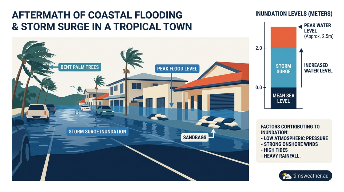
Coastal town experiencing extensive storm surge flooding following a severe tropical cyclone.
For decades, meteorologists relied heavily on the Dvorak Technique to estimate storm intensity using visible and infrared satellite imagery. However, the Dvorak Technique has a major limitation when identifying eyewall replacement cycles. The intense thunderstorms of the outer eyewall generate a massive, thick cirrus cloud canopy that obscures the lower levels of the storm, making it impossible to see the concentric eyewalls using standard infrared cameras.
Microwave satellite imagery and radar signatures
To see through the cirrus canopy, forecasters use microwave satellite imagery. Microwave sensors detect the large ice particles and heavy liquid water deep inside the rainbands, effectively stripping away the upper-level clouds. This allows agencies like the Joint Typhoon Warning Center (JTWC) to see the double eyewall structure clearly. During an active event, a NOAA National Hurricane Center forecast discussion will explicitly diagnose a completed cycle when microwave passes show the outer ring dominating the core.
How to Identify Concentric Eyewalls on Himawari-9 Satellite Data
When monitoring the Australian region, identifying concentric eyewalls on Himawari-9 satellite data requires specialised processing. The Himawari-9 satellite provides frequent updates, and by applying specific enhancement curves to the infrared data, forecasters can sometimes detect the subtle temperature differences of the moat region. When a system moves close to the coast, land-based Doppler radar becomes the best tool. BOM radar signatures of replacement cycles during landfalling events in North Queensland have shown clear double-ring structures, allowing forecasters to issue more accurate short-term warnings through the Australian Integrated Forecast System.
Impact of eyewall replacement on storm surge and wind field expansion
While the temporary drop in a storm's category might seem like good news, an eyewall replacement cycle often increases the total destructive potential of a cyclone. The BOM tropical cyclone severity scale focuses on peak wind gusts, but the total footprint of those winds is highly important for public safety.
Why does a cyclone get larger after an eyewall replacement cycle?
A cyclone gets larger because the new outer eyewall forms at a much greater distance from the centre than the original eye. As this outer ring of intense thunderstorms becomes the dominant structure, it drags the surrounding wind field outward with it. Even though the maximum sustained winds at the absolute centre might be lower, gale-force and destructive winds now cover a significantly larger geographic area.
Post-ERC Wind Field Expansion: Implications for Coastal Storm Surge
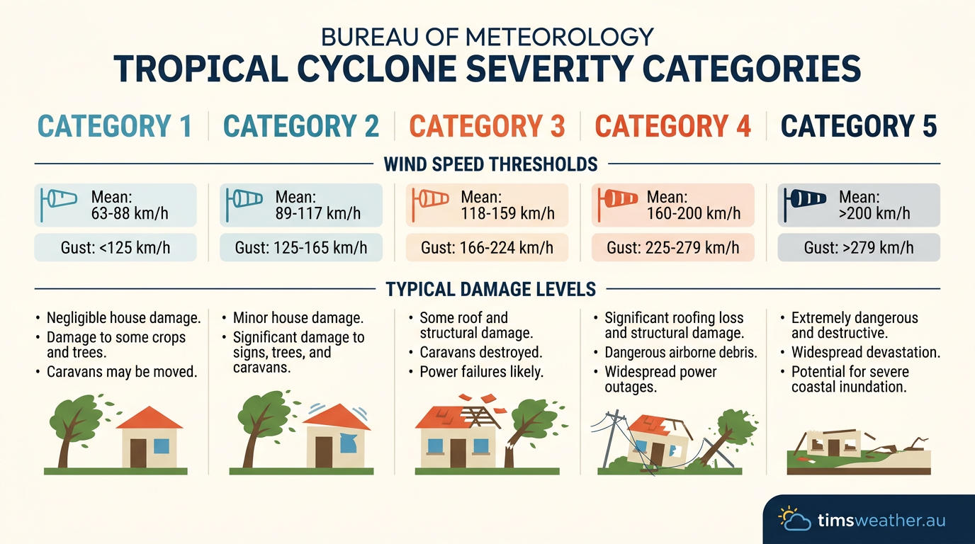
Bureau of Meteorology tropical cyclone severity scale showing Categories 1 to 5.
Post-ERC wind field expansion has major implications for coastal storm surge. Storm surge is driven largely by the sheer volume of water that prolonged, strong winds can push towards the shore. A cyclone with a massive wind field will generate a much larger storm surge than a compact storm with higher peak winds. This wide footprint means that coastal communities well outside the direct landfall zone can experience severe coastal flooding.
Inland wind risks for remote communities
Inland, the expanded wind field poses a different threat. For remote Western Australian mining communities situated hundreds of kilometres from the coast, a broader cyclone means destructive gusts will penetrate much further inland before the system spins down, threatening infrastructure that might otherwise have escaped the worst winds.
Australian and global examples of eyewall replacement
Throughout history, the erratic intensity changes caused by these structural shifts have complicated emergency responses worldwide. Examining historical storms provides insight into how these cycles play out over different ocean basins.
Cyclone Yasi and Australian landfalls
Severe Cyclone Yasi in 2011 is a prime example of an expanded wind field impacting Australia. As Yasi moved across the Coral Sea, it underwent structural changes that broadened its core. By the time it made landfall near Mission Beach, its destructive winds covered an enormous stretch of the North Queensland coastline. Similarly, Severe Cyclone Debbie in 2017 exhibited complex internal changes before striking the Whitsunday region, causing significant forecast challenges.
The role of Australian sea surface temperatures in ERC progression is particularly evident in the Arafura and Timor Seas. Very intense but compact storms like Cyclone Tracy in 1974 or Cyclone Monica in 2006 were physically too small and fast-moving to undergo massive replacement cycles before hitting the coast. In contrast, larger systems with more marine heat energy have the capacity to undergo clear concentric eyewall phases.
Typhoon systems in the western North Pacific
In the western North Pacific, typhoons frequently undergo rapid, successive cycles due to the vast expanses of warm water. For instance, Typhoon Dolphin demonstrated repeated structural shifts. During a real-time analysis, observers noted Dolphin struggling to maintain a single core, cycling through multiple replacement phases. Similarly, Typhoon Bavi expanded dramatically. As reported by Fox Weather, Typhoon Bavi underwent an eyewall replacement cycle that expanded its wind field just as it moved towards populated areas.
Global benchmarks: Hurricane Ian and Katrina
Globally, these cycles are a defining feature of the most catastrophic storms. When Hurricane Katrina entered the Gulf of Mexico in 2005, it reached Category 5 on the Saffir-Simpson Hurricane Wind Scale. Before making landfall, it underwent a replacement cycle. While this dropped its peak winds to Category 3, it expanded Katrina's wind field to an exceptional size, generating a massive storm surge that overwhelmed New Orleans.
More recently, Hurricane Ian provided excellent real-time data on structural expansion. The NASA Earth Observatory reported satellite sensors capturing a massive outer ring forming just before the system struck Florida, perfectly illustrating the dangerous wind field expansion that follows an inner core collapse.
Frequently asked questions
An eyewall replacement cycle begins when a mature, intense cyclone develops a second ring of thunderstorms outside its original eyewall. This outer ring starts competing for moisture and inflow. As the outer ring strengthens, the inner eyewall is gradually starved of energy, leading to its eventual collapse and replacement.
Source: aoml.noaa.gov
Further reading and resources
Explore trusted articles, books, videos and other resources to go deeper on this topic.
youtube.comVideo
Eyewall Replacement Cycles Inside Hurricanes
Video coverage on How Do Eyewall Replacement Cycles Happen? Cyclone Evolution Explained from youtube.com.
en.wikipedia.orgReference
Eyewall replacement cycle
Background reference on How Do Eyewall Replacement Cycles Happen? Cyclone Evolution Explained from en.wikipedia.org.
theweatherprediction.comArticle
EYEWALL REPLACEMENT CYCLE
In-depth coverage on How Do Eyewall Replacement Cycles Happen? Cyclone Evolution Explained from theweatherprediction.com.
aoml.noaa.govReference
Paper on the unusual eyewall replacement cycles in ...
Background reference on How Do Eyewall Replacement Cycles Happen? Cyclone Evolution Explained from aoml.noaa.gov.
repository.library.noaa.govReference
Documenting the Progressions of Secondary Eyewall ...
Background reference on How Do Eyewall Replacement Cycles Happen? Cyclone Evolution Explained from repository.library.noaa.gov.
aos.wisc.eduReference
INVESTIGATION AND PREDICTION OF HURRICANE ...
Background reference on How Do Eyewall Replacement Cycles Happen? Cyclone Evolution Explained from aos.wisc.edu.
hurricaneville.comArticle
Eyewall Replacement Cycle
In-depth coverage on How Do Eyewall Replacement Cycles Happen? Cyclone Evolution Explained from hurricaneville.com.
journals.ametsoc.orgArticle
Documenting the Progressions of Secondary Eyewall ...
In-depth coverage on How Do Eyewall Replacement Cycles Happen? Cyclone Evolution Explained from journals.ametsoc.org.
tropical.colostate.eduReference
Eyewall replacement cycle
Background reference on How Do Eyewall Replacement Cycles Happen? Cyclone Evolution Explained from tropical.colostate.edu.
Hurricane Eyewall Replacement Cycle Thermodynamics and ...
In-depth coverage on How Do Eyewall Replacement Cycles Happen? Cyclone Evolution Explained from journals.ametsoc.org.
Planning weeks ahead?
Check Australia's long-range seasonal outlook for rainfall, temperature and the climate drivers (ENSO, IOD, SAM, MJO) shaping the next three months.
View Australia's Seasonal Weather Forecast