
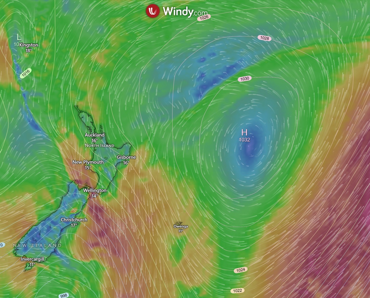
How do high-pressure systems form? High-pressure systems form when cooler, denser air in the upper atmosphere converges and begins sinking toward the Earth's surface. As this air subsides, it undergoes adiabatic warming, which prevents moisture from condensing into clouds, leading to the clear, stable weather conditions typically associated with these anticyclonic systems.
Key takeaways
High-pressure systems develop when air aloft converges and descends through the atmospheric column, increasing the mass and pressure at the surface.
The subsiding air warms adiabatically as it compresses, which lowers relative humidity and heavily suppresses cloud formation.
Surface winds flow outward from the high-pressure centre, spiralling in a direction determined by the Coriolis effect.
Persistent anticyclones can form long-lasting blocking patterns that steer storms away and generate temperature extremes.
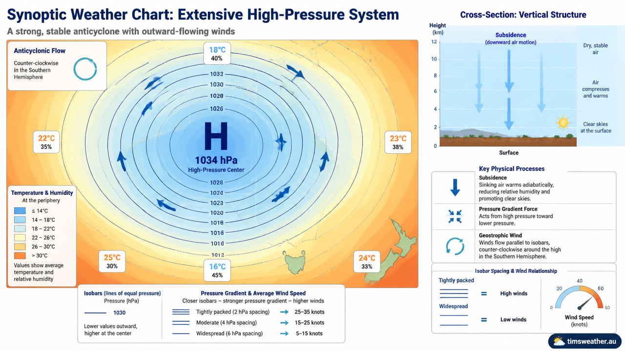
Synoptic chart displaying isobars around a high-pressure system
How convergence and divergence drive anticyclone development
Anticyclones are areas of high atmospheric pressure that are generally associated with sinking air, clear skies and relatively stable weather. Their development is closely linked to the movement of air in the upper and lower parts of the atmosphere.
Divergence aloft can help initiate or strengthen an anticyclone. When air spreads outward at high altitude, air from below rises to replace it. This removes mass from the atmospheric column and can initially cause surface pressure to fall. However, once the upper-level circulation changes and air begins to converge aloft, the opposite process occurs: air accumulates in the column and is forced downward.
As air sinks, it increases the mass of air above the surface, causing surface atmospheric pressure to rise and strengthening the anticyclone. Near the surface, air then flows outward from the centre of high pressure, producing surface divergence.
The process can therefore be summarised as:
Upper-level convergence → sinking air → increasing surface pressure → surface divergence → strengthening anticyclone
As the air descends, it is compressed and warms adiabatically. This warming reduces relative humidity and suppresses cloud formation, which is why mature anticyclones are often associated with clear skies, light winds and dry, stable conditions.
In the Southern Hemisphere, air flowing outward around an anticyclone rotates anticlockwise due to the Coriolis effect.
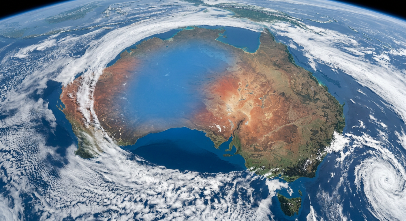
Satellite imagery showing completely clear skies over a landmass due to a persistent high-pressure system
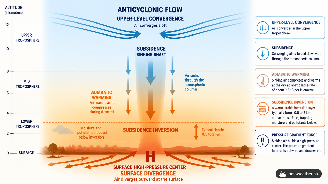
Diagram of sinking air causing atmospheric mass accumulation in an anticyclone
The Vertical Anatomy: How Subsidence Drives Adiabatic Warming
The vertical movement of air within a high-pressure system explains almost all the weather phenomena associated with it. From my perspective as an educator in atmospheric science, the physical principles of air density and gravity provide the clearest explanation for why anticyclones bring sunny days.
What causes high-pressure systems to form in the atmosphere?
High-pressure systems form in the atmosphere when widespread subsidence compresses the air. Because the atmospheric pressure is greater near the ground than it is at high altitudes, the descending air parcel is squeezed into a smaller volume. According to the laws of thermodynamics, this compression increases the internal temperature of the air, a process called adiabatic warming.
During adiabatic warming, the air temperature rises by approximately 9.8 degrees Celsius for every 1,000 metres it falls, assuming no heat is exchanged with the surrounding environment. As the air warms, its capacity to hold invisible water vapour increases. This causes the relative humidity to drop sharply. The dry, sinking air effectively evaporates existing cloud droplets and prevents new ones from forming, which is why cumulus clouds form rarely under strong high-pressure systems.
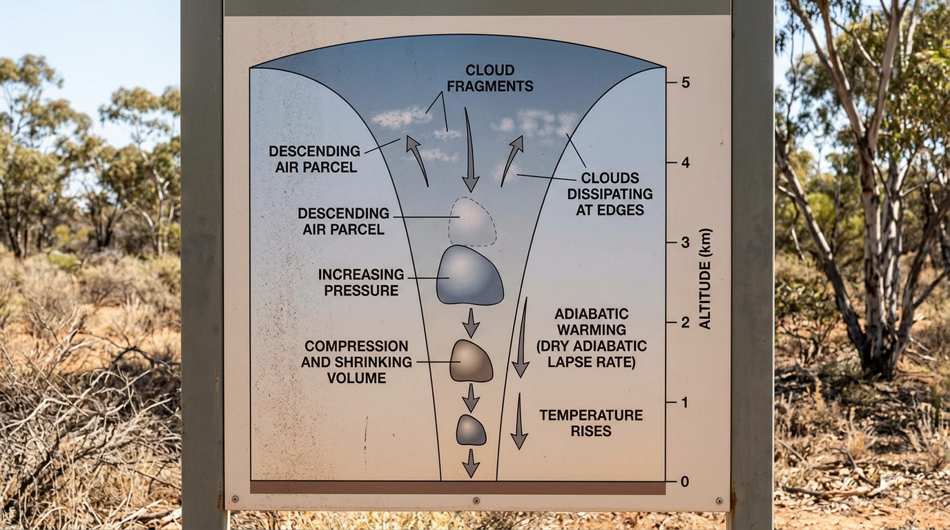
Scientific diagram of adiabatic warming during air subsidence
Why does subsiding air create high pressure?
Subsiding air creates high pressure because the constant downward momentum adds physical weight to the atmospheric column. Also, the World Meteorological Organization International Cloud Atlas identification principles show that this subsidence creates an inversion layer. An inversion occurs when a layer of warm, sinking air rests on top of a cooler layer near the surface. This inversion acts like a physical lid, trapping the air below and stopping any vertical development that would normally lead to rain.
Anticyclones and the Coriolis Effect: Why Winds Spiral Clockwise in the Northern Hemisphere
While the vertical motion is downward, the horizontal motion is equally important. A high-pressure system is also called an anticyclone, a term that describes its specific wind circulation pattern.
As the air hits the surface and diverges outward toward areas of lower pressure, the rotation of the Earth deflects its path. This deflection is known as the Coriolis effect. According to www.cordulus.com, the outward air flow influenced by the Coriolis effect creates clockwise rotation in the Northern Hemisphere and counter-clockwise in the Southern Hemisphere.
Meteorologists draw isobars on synoptic charts to represent lines of equal pressure. In a strong anticyclone, these isobars are often widely spaced near the centre, indicating very light winds. Further out from the centre, the pressure gradient increases, and the anticyclonic winds flow parallel to the isobars, steering weather systems and moisture across vast distances.
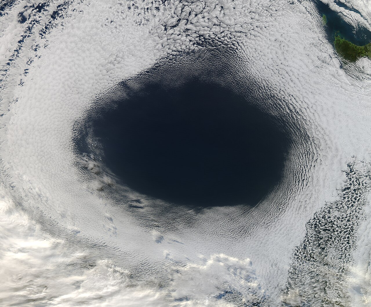
Satellite view reveals clear ocean surrounded by distinct cloud patterns, a visual representation of high-pressure system formation and its meteorological effects. By NASA, MODIS Rapid Response System - http://lance-modis.eosdis.nasa.gov/wms/?zoom=5&lat=-16.87793&lon=160.16895&layers=B0000FFFFT&datum1=06/05/2012, Public Domain, https://commons.wikimedia.org/w/index.php?curid=24628352
Global circulation: Hadley cells and subtropical ridges
High-pressure systems are not just random daily occurrences; many are permanent fixtures of the global climate. The largest anticyclones on Earth are driven by the Hadley cell circulation.
Near the equator, intense solar heating causes massive amounts of air to rise. This air moves poleward high in the troposphere. By the time it reaches about 20 to 40 degrees latitude in both hemispheres, it cools, converges, and sinks back to the surface. This planetary-scale subsidence creates semi-permanent belts of high pressure known as subtropical ridges.
These sprawling anticyclones steer ocean currents and dictate the seasonal tracks of storms. Because they guide prevailing winds, they also influence where tropical cyclones form and travel. Major regional systems include the Azores/Bermuda High in the Atlantic, the Pacific High, the Siberian High in winter, the Mascarene High in the Indian Ocean, and the West Pacific High. These features are central to monsoon steering and strongly dictate seasonal rainfall anomalies across the globe.
Thermal highs versus dynamic highs
Meteorologists classify high-pressure systems into two primary categories based on how they develop: thermal highs and dynamic highs.
Thermal highs
Thermal highs form primarily due to intense cooling at the Earth's surface. When landmasses cool drastically during winter, the air immediately above the ground chills and becomes extremely dense. This dense air settles, creating a shallow but intense high-pressure system. The Siberian High is a classic example of a thermal high. Similar, albeit weaker, systems often form rapidly behind passing weather fronts, altering conditions just as cold fronts form and move away.
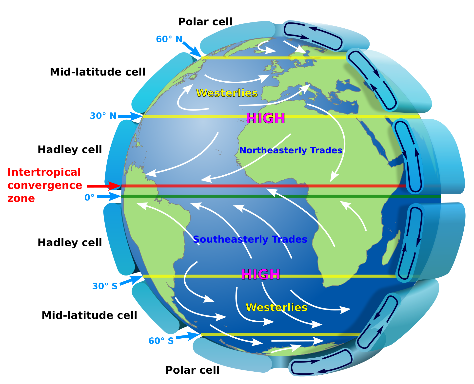
Earth Global Circulation - en Image: “Earth Global Circulation - en” by Kaidor, via Wikimedia Commons (CC BY-SA 3.0).
Dynamic highs
Dynamic highs form from the mechanical convergence of air aloft, as seen in the subtropical ridges. These are much deeper systems that extend high into the troposphere. A common global mechanism involves Rossby waves, which are massive meanders in the high-altitude jet stream. Peer-reviewed literature regarding the role of Rossby waves in ridge amplification shows that when these waves slow down, they can generate massive areas of upper-level convergence, building intense dynamic highs.
Unlike the sinking motion in a high, en.wikipedia.org notes that low-pressure systems occur due to wind divergence in the upper atmosphere or thermal heating, demonstrating the exact opposite mechanism in atmospheric physics.
Characteristics of High vs. Low Pressure Systems
To fully grasp how high pressure influences the atmosphere, it helps to compare it directly against low-pressure systems. How the structural differences clarifies why one brings clear skies and the other brings storms.
Feature | High-Pressure System (Anticyclone) | Low-Pressure System (Cyclone) | Weather Impact |
|---|---|---|---|
Vertical air motion | Sinking (subsidence) | Rising (ascent) | Highs clear the sky; lows build clouds. |
Surface air flow | Diverging (moving outward) | Converging (moving inward) | Highs displace moisture; lows concentrate it. |
Temperature change | Adiabatic warming | Adiabatic cooling | Highs lower humidity; lows raise humidity. |
Cloud formation | Strongly inhibited | Strongly encouraged | Highs cause dry weather; lows cause rain. |
What is the difference between an anticyclone and a high-pressure system?
There is no structural difference between an anticyclone and a high-pressure system; the two terms describe the same meteorological phenomenon from different perspectives. "High-pressure system" refers to the measurable weight and mass of the descending air column, whereas "anticyclone" refers specifically to the outward, spiralling wind patterns created by that pressure gradient at the surface.
From Clear Skies to Blocking Patterns: The Meteorological Impact of Highs
The environmental impacts of anticyclones dictate daily weather and long-term climate. While they are famous for fine weather, they can also cause severe environmental stress.
How do high-pressure systems influence local weather?
High-pressure systems influence local weather by providing calm winds, dry air, and clear skies. However, because they eliminate cloud cover, they allow for maximum incoming solar radiation during the day and maximum outgoing longwave radiation at night. This lack of an insulating cloud blanket often leads to extreme temperature variations. An article from www.ecoflow.com points out that high pressure systems lead to clear skies and temperature extremes due to descending air that prevents cloud formation.
During cold months, the rapid nocturnal cooling under a strong high allows the surface temperature to plummet. This is precisely how radiation fog form processes begin, as the ground chills the lowest layer of air to its dew point. In less extreme cases, this identical clear-sky cooling mechanism dictates how dew form patterns appear on morning grass.
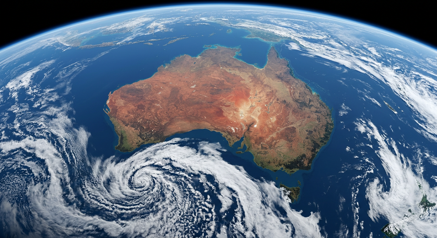
Satellite imagery showing completely clear skies over a landmass due to a persistent high-pressure system
Satellite imagery and heat domes
Meteorologists use specific satellite imagery interpretation cues for identifying anticyclones. On water vapour satellite loops, strong high-pressure systems usually appear as vast, dark, featureless regions because they are typically associated with dry air and little cloud. This darkness indicates exceptionally dry air throughout the middle and upper troposphere, confirming the presence of strong subsidence.
When a dynamic high becomes geographically trapped and stops moving, it is called a blocking high. A blocking high is a quasi-stationary anticyclonic anomaly that disrupts the jet stream, forcing migrating low-pressure storm systems to detour entirely around the region. During summer, persistent highs can be called heat domes because the unrelenting subsidence traps sensible heat near the surface, suppresses all cloud formation, and bakes the sector beneath it, frequently resulting in prolonged heatwaves and droughts.
Frequently asked questions
High-pressure systems form when air cools and sinks through the atmosphere, eventually piling up near the surface. As this air descends, it compresses and warms, which increases the pressure at ground level. This sinking motion suppresses cloud formation and rain, creating stable and settled weather conditions for the area.
Source: nesdis.noaa.gov
Further reading and resources
Explore trusted articles, books, videos and other resources to go deeper on this topic.
kestrelinstruments.comArticle
What Is a High-Pressure System and How Can You ...
In-depth coverage on How Do High-Pressure Systems Form? The Complete Meteorological Guide from kestrelinstruments.com.
weather.govReference
Basic Discussion on Pressure
Background reference on How Do High-Pressure Systems Form? The Complete Meteorological Guide from weather.gov.
scied.ucar.eduReference
The Highs and Lows of Air Pressure
Background reference on How Do High-Pressure Systems Form? The Complete Meteorological Guide from scied.ucar.edu.
pilotinstitute.comArticle
High vs. Low-Pressure Systems Explained
In-depth coverage on How Do High-Pressure Systems Form? The Complete Meteorological Guide from pilotinstitute.com.
en.wikipedia.orgReference
High-pressure area
Background reference on How Do High-Pressure Systems Form? The Complete Meteorological Guide from en.wikipedia.org.
youtube.comVideo
High vs. Low-Pressure Weather Systems: What's the Difference?
Video coverage on How Do High-Pressure Systems Form? The Complete Meteorological Guide from youtube.com.
aopa.orgArticle
Pressure Systems
In-depth coverage on How Do High-Pressure Systems Form? The Complete Meteorological Guide from aopa.org.
noaa.govReference
Air Pressure | National Oceanic and Atmospheric ...
Background reference on How Do High-Pressure Systems Form? The Complete Meteorological Guide from noaa.gov.
avalanche.orgArticle
High Pressure / High Pressure Ridge
In-depth coverage on How Do High-Pressure Systems Form? The Complete Meteorological Guide from avalanche.org.
nesdis.noaa.govReference
What Are High and Low Pressure Systems? | NESDIS - NOAA
Background reference on How Do High-Pressure Systems Form? The Complete Meteorological Guide from nesdis.noaa.gov.
Planning weeks ahead?
Check Australia's long-range seasonal outlook for rainfall, temperature and the climate drivers (ENSO, IOD, SAM, MJO) shaping the next three months.
View Australia's Seasonal Weather Forecast