

How does intra-cloud lightning form? It comes down to the charge separation occurring within a cumulonimbus cloud. As updrafts carry ice crystals upward, they collide with heavier, riming graupel. This process creates a positive charge at the cloud top and a negative charge in the middle, triggering an electrical discharge within the cloud.
Key takeaways
Sudden 'lightning jumps' often signal a storm is about to intensify, improving severe weather forecasting.
The primary driver of this charge separation is the non-inductive charging mechanism, which relies on the collision of ice crystals and graupel.
Strong vertical updrafts are required to physically separate lighter, positively charged particles from heavier, negatively charged particles.
Space-based tools like the Geostationary Lightning Mapper allow meteorologists to track internal lightning flashes that ground sensors often miss.
How does intra-cloud lightning form: The microphysics of ice-crystal collisions

Comparison of intra-cloud and cloud-to-ground lightning discharge characteristics.
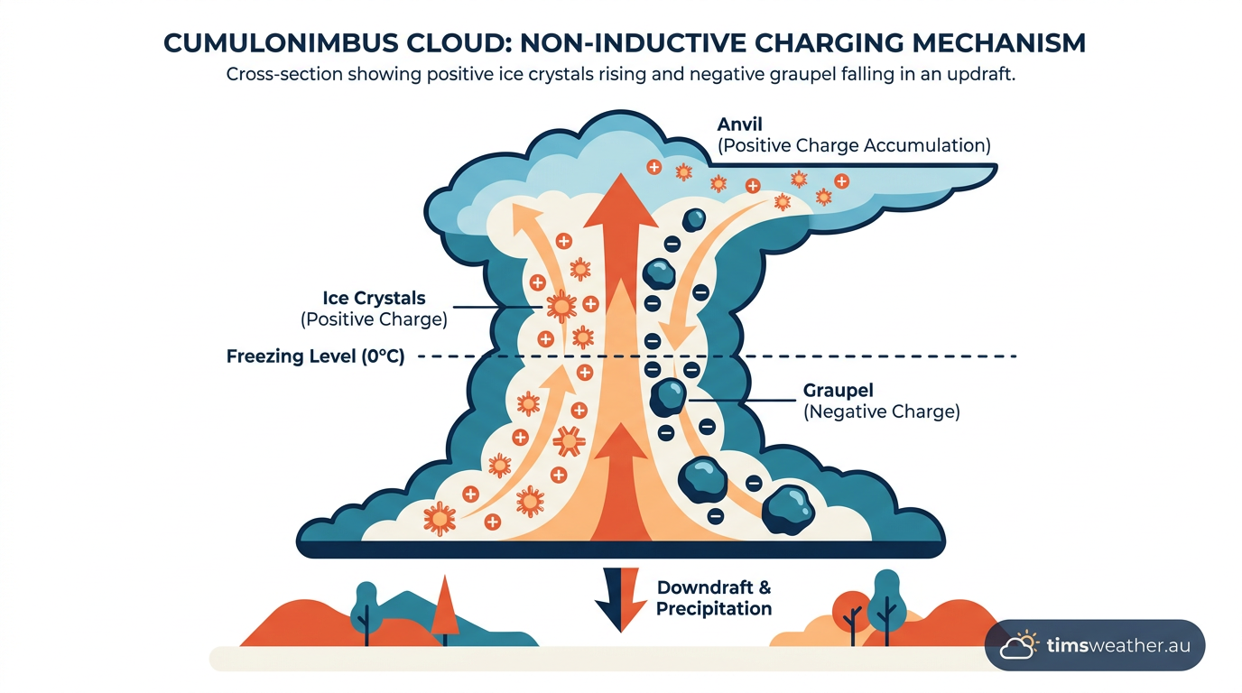
Diagram illustrating how does intra-cloud lightning form via charge separation with ice crystals and graupel.
The Role of Vertical Updrafts in Charge Polarity

Spider lightning spreading horizontally across the base of a mature cumulonimbus cloud.
Generating a charge is only the first step. For a lightning flash to occur, those positive and negative charges must be physically pushed apart to create an electric dipole. This physical separation is managed by the storm's internal wind patterns.
Building the tripolar charge structure
The lifecycle of a thunderstorm contains cumulus, mature, and dissipation stages (www.readygallatin.com). During the cumulus and mature stages, strong vertical updrafts sweep through the center of the cloud. These air currents are powerful enough to carry the lightweight, positively charged ice crystals high into the upper troposphere, eventually spreading out to form the storm's anvil top.
Meanwhile, the negatively charged graupel is much heavier. It resists the upward push of the wind and either remains suspended in the middle levels of the cloud or slowly falls toward the lower levels. This mechanical sorting results in the classic tripolar charge structure observed in mature thunderstorms:
Upper region: A massive layer of positive charge residing in the frozen upper cloud and anvil.
Middle region: A concentrated zone of negative charge where the graupel accumulates.
Lower region: A smaller, weaker area of positive charge near the cloud base, caused by falling precipitation and warmer temperatures.
If you have ever wondered how do cumulonimbus clouds form into severe weather producers, this internal sorting mechanism is a major factor. The growing distance between the positive cloud top and the negative middle layer stretches the electric field until the air itself can no longer act as an insulator.

Tripolar electrical charge structure inside a cumulonimbus cloud showing positive and negative regions.
Dielectric breakdown and the discharge process
Air is naturally an excellent electrical insulator. However, as the updrafts continue to pack positive charges at the top and negative charges in the middle, the electric field strength reaches a critical threshold—often tens of thousands of volts per meter. When the electrical potential overcomes the insulating capacity of the surrounding air, dielectric breakdown occurs.
The discharge begins as an invisible channel of ionized air called a stepped leader. In intra-cloud lightning, this leader typically initiates in the negative middle region and branches upward toward the positive upper region. As the leader connects the two opposing charge centers, a massive current surges through the ionized channel. This sudden equalization releases immense energy, typically around 1 billion joules per lightning strike, and heats the surrounding air channel to approximately 30,000°C. (en.wikipedia.org).
This extreme, instantaneous heating causes the surrounding air to expand explosively, creating the shockwave we hear as thunder. Learning how does thunder form helps explain why intra-cloud flashes sometimes produce a low, rumbling sound rather than a sharp crack; the sound waves are muffled and scattered by the thick cloud base and the longer distance to the ground.
Distinguishing Intra-Cloud from Cloud-to-Ground Discharges
While the internal charging mechanisms remain similar, the path the lightning takes defines its classification. Meteorological agencies track both types to gauge storm intensity and public safety hazards.
What is the difference between intra-cloud and cloud-to-ground lightning?
The primary difference is the destination of the discharge channel. Intra-cloud lightning bridges the positive and negative regions entirely within the boundaries of the cumulonimbus cloud. The discharge never breaks through the cloud base to make contact with the Earth. Because it happens higher up and remains obscured by dense water vapor, it often appears to observers on the ground as a sudden, diffuse brightening of the cloud—commonly referred to as "sheet lightning."
Cloud-to-ground (CG) lightning, by contrast, occurs when the stepped leader exits the cloud base and travels downward, connecting with an upward-reaching streamer of opposite charge attached to a grounded object. If you want to know how does cloud-to-ground lightning form, the process involves the same initial charge separation, but the electrical path finds the ground to be the path of least resistance. While IC lightning is more frequent, CG lightning represents a direct hazard to human life. Lightning causes about 20 deaths annually in the U.S. alone, out of roughly 20 million cloud-to-ground flashes each year (weatherworksinc.com). Also, data shows that severe weather hazards, including lightning, require strict public awareness; for example, 13 lives have been lost in Wisconsin due to lightning over a 25-year period despite severe weather warnings (climatology.nelson.wisc.edu).

Intra-cloud lightning over the Baltic Sea. Stunning intra-cloud lightning illuminates a towering cumulonimbus cloud at night, vividly demonstrating the atmospheric physics behind its formation. By Lukas Schmidt - https://www.flickr.com/photos/elixias/40134760494/, CC BY-SA 2.0, https://commons.wikimedia.org/w/index.php?curid=68526500
Does intra-cloud lightning strike the ground?
No, intra-cloud lightning does not strike the ground. By definition, an intra-cloud flash begins and ends within the storm's internal structure. However, it is essential to remember that lightning can occur between opposite charges within a storm cloud or between the cloud and the ground interchangeably during a single storm's lifespan (www.facebook.com). An abundance of IC lightning overhead is a clear warning that the storm is electrically active and that a cloud-to-ground strike could occur at any moment.
Discharge Type | Primary Path | Charge Connection | Visual Indicator |
|---|---|---|---|
Intra-Cloud (IC) | Internal cloud structure | Negative middle to positive top | Sheet lightning glow; branching in anvil |
Cloud-to-Ground (CG) | Cloud base to Earth surface | Negative base to positive ground | Distinct vertical channel; intense brightness |
Cloud-to-Cloud (CC) | Between two distinct storm cells | Charge regions across separate clouds | Visible channels crossing clear air |
Detecting IC Lightning: How Meteorologists Map the Storm Interior
For decades, ground-based lightning detection networks primarily captured cloud-to-ground strikes. These systems rely on measuring the very low frequency (VLF) and low frequency (LF) radio waves emitted by the massive return stroke of a ground contact. Intra-cloud lightning produces much weaker radio signatures, making it difficult for ground sensors to map accurately.
The Geostationary Lightning Mapper (GLM)
Modern meteorology has solved this problem from space. Instruments like the Geostationary Lightning Mapper (GLM) aboard NOAA's GOES satellites monitor the Earth from orbit, looking down at the cloud tops. Instead of listening for radio waves, the GLM uses near-infrared optical sensors to detect the momentary flashes of light escaping through the top of the cumulonimbus cloud.
This technology is critical for severe weather forecasting. Researchers at the NOAA National Severe Storms Laboratory (NSSL) have shown that sudden, massive spikes in intra-cloud lightning—known as "lightning jumps"—often occur right before a storm intensifies. When updrafts strengthen dramatically, updrafts and supercooled water droplets collide faster, rapidly accelerating the charge separation process. Recognizing a sudden burst of IC flashes allows forecasters to issue earlier warnings for large hail, damaging winds, or supercell thunderstorm formation.
Spider lightning and visible manifestations
While most intra-cloud discharges look like diffuse flashes of sheet lightning from the ground, certain atmospheric conditions reveal their true structure. "Spider lightning" is a specific manifestation of intra-cloud lightning that occurs within the sprawling stratiform region trailing behind a mature thunderstorm.
Instead of a compact vertical spark, spider lightning features extensively branched, creeping channels of ionized air that spread horizontally across the underside of the cloud base. Because these flashes crawl along the lower cloud boundary rather than staying deep within the dense vertical core, observers can clearly see the detailed, web-like pathways stretching across the sky. These slow-moving flashes visually demonstrate how the electrical discharge seeks out pockets of positive charge scattered over vast distances within the storm's anvil.
Frequently asked questions
Intra-cloud lightning occurs when electrical charges separate within a cumulonimbus cloud, typically in regions containing both ice crystals and supercooled water. Frequent collisions between these ice particles build up opposite charges until the electric field becomes intense enough to trigger a rapid electrical discharge contained entirely within the cloud.
Source: weatherquest.co.uk
Further reading and resources
Explore trusted articles, books, videos and other resources to go deeper on this topic.
weather.govReference
Understanding Lightning Science
Background reference on How Does Intra-Cloud Lightning Form? The Atmospheric Physics Explained from weather.gov.
youtube.comVideo
How does lightning form? | Weather Wise Lessons - YouTube
Video coverage on How Does Intra-Cloud Lightning Form? The Atmospheric Physics Explained from youtube.com.
scied.ucar.eduReference
Thunder and Lightning - UCAR Center for Science Education
Background reference on How Does Intra-Cloud Lightning Form? The Atmospheric Physics Explained from scied.ucar.edu.
en.wikipedia.orgReference
Lightning
Background reference on How Does Intra-Cloud Lightning Form? The Atmospheric Physics Explained from en.wikipedia.org.
rmets.orgArticle
Types of Lightning | Royal Meteorological Society
In-depth coverage on How Does Intra-Cloud Lightning Form? The Atmospheric Physics Explained from rmets.org.
noaa.govReference
How Lightning is Created - NOAA
Background reference on How Does Intra-Cloud Lightning Form? The Atmospheric Physics Explained from noaa.gov.
britannica.comReference
Intracloud lightning | meteorology - Britannica
Background reference on How Does Intra-Cloud Lightning Form? The Atmospheric Physics Explained from britannica.com.
psu.eduReference
A bolt is born! Atmospheric events underpinning lightning strikes ...
Background reference on How Does Intra-Cloud Lightning Form? The Atmospheric Physics Explained from psu.edu.
sciencefocus.comArticle
What causes lightning? The simple science, explained
In-depth coverage on How Does Intra-Cloud Lightning Form? The Atmospheric Physics Explained from sciencefocus.com.
miops.comArticle
Lightning Types and Classifications: A Creative Photography Guide - MIOPS
In-depth coverage on How Does Intra-Cloud Lightning Form? The Atmospheric Physics Explained from miops.com.
Planning weeks ahead?
Check Australia's long-range seasonal outlook for rainfall, temperature and the climate drivers (ENSO, IOD, SAM, MJO) shaping the next three months.
View Australia's Seasonal Weather Forecast