
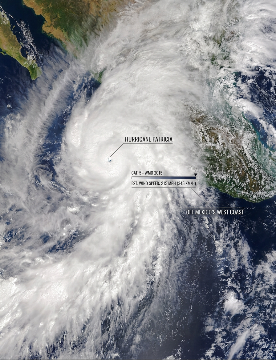
Hurricane Patricia's strongest winds ever recorded reached an estimated 345 km/h (215 mph) off the Pacific coast of Mexico in October 2015. That peak, along with a minimum central pressure of 872 hPa, made Patricia one of the most intense tropical cyclones ever observed in the Western Hemisphere.
Key takeaways
Hurricane Patricia intensified with exceptional speed over the Eastern Pacific basin in October 2015.
The National Hurricane Center reported maximum sustained winds of 345 km/h (215 mph) from Hurricane Hunters reconnaissance and satellite analysis.
Six deaths and an estimated US$325 million in damage were recorded after the record-breaking cyclone made landfall.
Strong El Niño conditions helped warm the eastern North Pacific and supported rapid strengthening.
Patricia weakened before landfall on the Mexican coast, which limited the worst impacts onshore.
Hurricane Patricia strongest winds ever recorded: what made the storm so unusual?
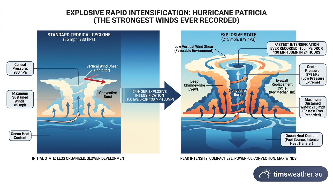
Why was Hurricane Patricia so unusual? It combined very warm ocean water, low wind shear and an unusually efficient storm core, which let it intensify far faster than most hurricanes in the Eastern Pacific basin. The National Hurricane Center described Patricia as a case of extreme rapid intensification, meaning the winds strengthened profoundly over a short 24-hour period.
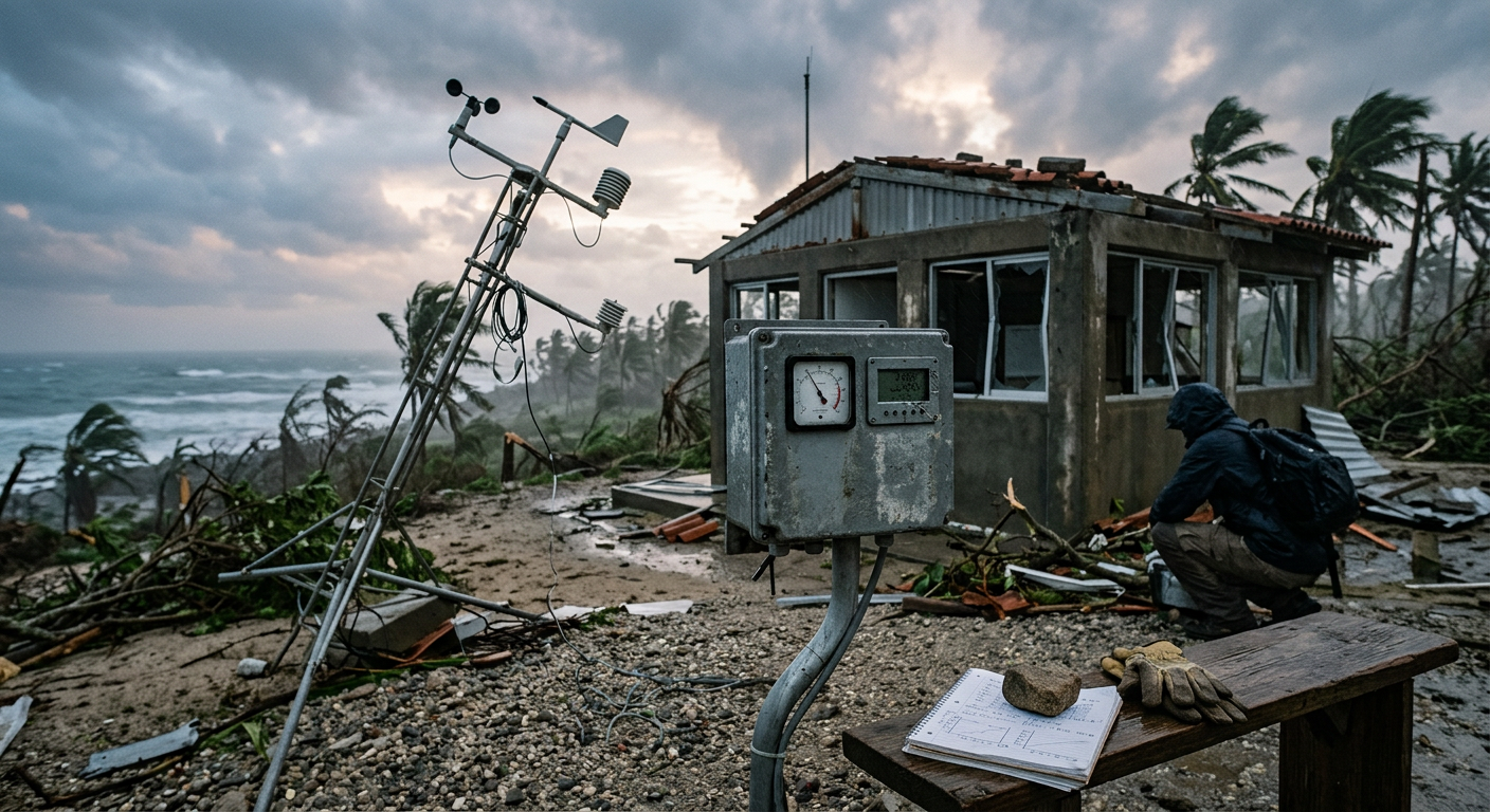
How did Hurricane Patricia reach record-breaking hurricane intensity?
Patricia reached record-breaking hurricane intensity because several favouring factors acted at once. The strongest of them was the 2015 El Niño event, which helped warm waters across the eastern North Pacific and supported a deeper pool of warm water beneath the surface. That extra ocean heat reduced the storm’s ability to mix up cooler water as it strengthened.
That matters because a hurricane is a heat engine. Warm ocean water feeds rising air, rising air lowers surface pressure, and lower pressure helps the wind field tighten further. When the upper atmosphere also vents air efficiently, the whole system can spin up very quickly. Patricia had that kind of outflow, so air rising in the eyewall could escape at height instead of piling up over the centre.
Patricia’s rapid intensification was also a forecasting challenge. Satellite estimates showed a very symmetric storm with extremely cold cloud tops, but satellites cannot measure the air inside the core directly. That is why Hurricane Hunters reconnaissance became so important. Aircraft data gave forecasters a closer look at the pressure, wind and temperature structure inside the storm.
For readers comparing storm behaviour, Patricia fits the same broad physics used to explain how do hurricanes form and how does the eye of a hurricane form. The details vary from storm to storm, but the core ingredients stay the same: heat, moisture, rotation and a low-shear environment.
Hurricane Patricia wind speed data and the role of Hurricane Hunters reconnaissance
Hurricane Patricia wind speed data came from a mix of satellite estimates and direct aircraft observation, with the National Hurricane Center relying on Hurricane Hunters reconnaissance to confirm just how intense the storm had become. The aircraft dropped instruments through the eyewall to sample pressure, wind and humidity as they fell through the storm.
Those dropsondes matter because they measure conditions in the storm rather than infer them from cloud shape alone. In Patricia’s case, the readings supported the very deep central pressure and extreme maximum sustained hurricane winds that made the system stand out from other eastern Pacific hurricanes. The National Hurricane Center used those aircraft observations alongside satellite data to finalise the best estimate of peak intensity. NOAA NESDIS
It is common for the strongest storms to outgrow what satellite-only methods can comfortably resolve. Once a cyclone becomes tightly organised, the cloud pattern can look nearly perfect while the pressure and wind field continue to change underneath. That is why direct reconnaissance still matters in the Atlantic and eastern Pacific when aircraft are available.
Maximum sustained winds versus gusts
Patricia’s headline number was its maximum sustained winds, not a short gust. That distinction matters. Sustained wind is averaged over a set period and is the standard used by the National Hurricane Center for hurricane intensity. Gusts can be higher, but they do not define the category on the Saffir-Simpson Hurricane Wind Scale.
If you want to see how category thresholds work in practice, hurricane categories explained gives a plain guide to the wind speeds used by the scale. Patricia reached Category 5 intensity, but Category 5 is the highest category on the Saffir-Simpson scale, so it was not far above the Category 5 threshold.
Beyond the gusts: comparing Hurricane Patricia to historical Atlantic Basin titans
Patricia is often compared with the strongest Atlantic Basin hurricanes because it reached extreme intensity, even though it formed in the Eastern Pacific. That comparison is useful, but the basins are not identical. Sea-surface temperatures, steering patterns and typical wind shear differ from one ocean to another, so the strongest storms in each basin can behave differently. Michael R. Lowry
What makes Patricia stand out is the combination of record-low pressure and very high maximum sustained winds. That combination is a strong sign of a compact, violent cyclone core. Even after it weakened before landfall, the storm still ranked among the most extreme hurricane systems ever measured. In the broader Pacific hurricane season history, very few storms approach that level of intensity. FOX Weather
For another angle on why storms can strengthen so fast, see how do tropical cyclones form and what is an eyewall replacement cycle. Patricia’s core did not need an eyewall replacement to become exceptional, but the structure of the eyewall is still central to understanding how intense hurricanes organise.
Patricia also shows why a single number does not tell the whole story. Wind speed, central pressure and size all matter. A storm with a lower pressure can still affect a small area, while a slightly weaker system may cover more coastline. That is one reason forecasters look at the full set of observations, not just the peak wind figure.

What happened as Hurricane Patricia approached land?
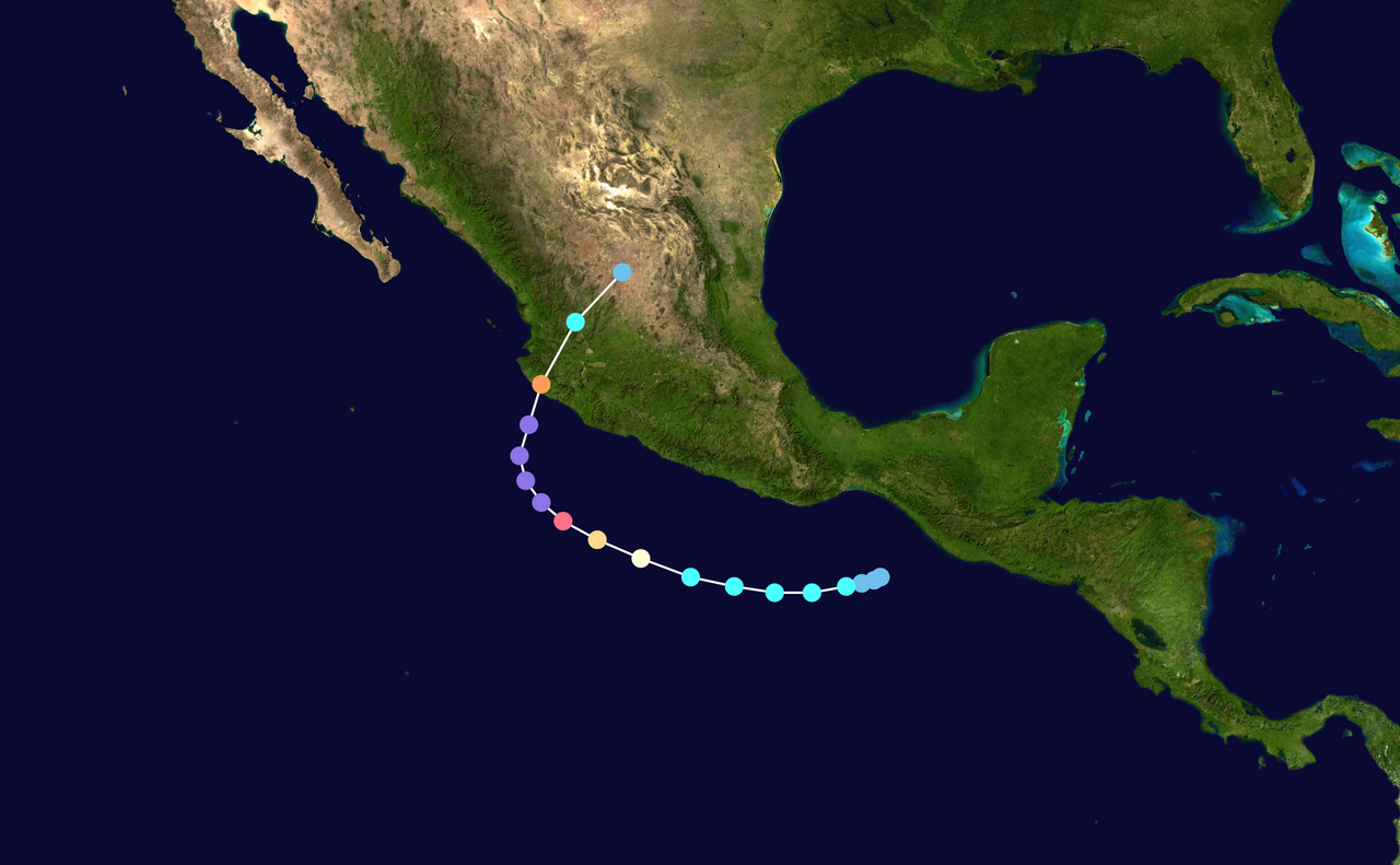
Patricia weakened before it reached land, which changed the outcome sharply. Hurricane Patricia caused two direct deaths and four indirect deaths, and preliminary damage was estimated at about US$325 million, while its impacts were limited because it weakened before landfall and struck a sparsely populated part of southwestern Mexico.
That weakening did not make the storm harmless. Strong winds, dangerous surf and heavy rain can still affect a coast even when the eye weakens before landfall. If you are near an exposed shoreline during a hurricane warning, the main hazards are often wind, water and debris together, not one on its own.
Patricia is a clear case of why intensity at sea and impact on land are related, but not identical. Forecasts need to track both. A Category 5 hurricane far offshore can still weaken rapidly if it crosses cooler water, encounters higher shear or starts to choke on its own upwelling. Scientific American
Why Hurricane Patricia still matters to forecasters
Hurricane Patricia still matters because it shows how fast a hurricane can intensify when the ocean and atmosphere line up. It also shows the value of direct observations, clear pressure measurements and careful use of the Saffir-Simpson Hurricane Wind Scale. For forecasters, Patricia remains a reference point for extreme eastern Pacific behaviour.
For readers, the lesson is simple. Very intense hurricanes can change quickly, but their structure still follows known physical rules. Warm water feeds the storm, low pressure tightens the core and outflow helps it breathe. Patricia just pushed those rules to an extreme.
Sources
Record-breaking Hurricanes Tracked by NOAA Satellites (nesdis.noaa.gov)
NOAA weather and atmospheric science reference (nhc.noaa.gov)
NOAA weather and atmospheric science reference (nhc.noaa.gov)
Paper on Hurricane Patricia, the most intense hurricane ever recorded in the Western Hemisphere, published in the Bulletin of the America… (aoml.noaa.gov)
NOAA weather and atmospheric science reference (nhc.noaa.gov)
World Meteorological Organization weather reference (wmo.int)
NOAA weather and atmospheric science reference (repository.library.noaa.gov)
NOAA weather and atmospheric science reference (nhc.noaa.gov)
Last verified: 2026-09-24
Frequently asked questions
At its peak on 23 October 2015, Hurricane Patricia reached maximum sustained winds of 215 mph, or approximately 345 km/h. These 1-minute sustained wind estimates make it the strongest tropical cyclone ever reliably measured by satellites, solidifying its place in meteorological history for extreme intensity in the eastern North Pacific.
Source: nesdis.noaa.gov
Further reading and resources
Explore trusted articles, books, videos and other resources to go deeper on this topic.
weather.comArticle
Three Years Ago, Hurricane Patricia Became the Record Strongest ...
In-depth coverage on Hurricane Patricia strongest winds ever recorded: why the 2015 storm was so extreme from weather.com.
climatesignals.orgArticle
Hurricane Patricia 2015 | Climate Signals
In-depth coverage on Hurricane Patricia strongest winds ever recorded: why the 2015 storm was so extreme from climatesignals.org.
pbs.orgArticle
The science of how Hurricane Patricia became so colossal | PBS News
In-depth coverage on Hurricane Patricia strongest winds ever recorded: why the 2015 storm was so extreme from pbs.org.
youtube.comVideo
Why did hurricane Patricia become a monster so quickly? - YouTube
Video coverage on Hurricane Patricia strongest winds ever recorded: why the 2015 storm was so extreme from youtube.com.
ebsco.comArticle
Hurricane Patricia | Earth and Atmospheric Sciences - EBSCO
In-depth coverage on Hurricane Patricia strongest winds ever recorded: why the 2015 storm was so extreme from ebsco.com.
humanidades.comArticle
Hurricane Patricia: what it is, effects and characteristics
In-depth coverage on Hurricane Patricia strongest winds ever recorded: why the 2015 storm was so extreme from humanidades.com.
guycarp.comArticle
Hurricane Patricia - Guy Carpenter
In-depth coverage on Hurricane Patricia strongest winds ever recorded: why the 2015 storm was so extreme from guycarp.com.
en.wikipedia.orgReference
Hurricane Patricia - Wikipedia
Background reference on Hurricane Patricia strongest winds ever recorded: why the 2015 storm was so extreme from en.wikipedia.org.
nasa.govReference
Patricia (Eastern Pacific) - NASA
Background reference on Hurricane Patricia strongest winds ever recorded: why the 2015 storm was so extreme from nasa.gov.
abc7news.comArticle
Hurricane Patricia and the other strongest hurricanes in history
In-depth coverage on Hurricane Patricia strongest winds ever recorded: why the 2015 storm was so extreme from abc7news.com.
Planning weeks ahead?
Check Australia's long-range seasonal outlook for rainfall, temperature and the climate drivers (ENSO, IOD, SAM, MJO) shaping the next three months.
View Australia's Seasonal Weather Forecast