

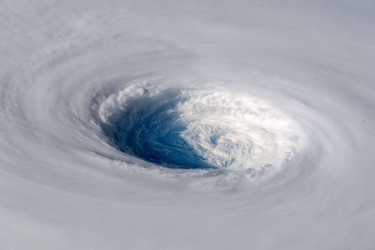
A hurrican eye forms as inward-rushing winds accelerate, the conservation of angular momentum causes air to spiral faster toward the centre. This creates a centrifugal force that prevents air from reaching the middle, forcing it to subside and warm adiabatically, resulting in the characteristic clear, calm hurricane eye.
Key takeaways
The eye is a calm, low-pressure centre that only develops when a hurricane reaches sufficient structural organisation.
The conservation of angular momentum acts as the primary physical driver, accelerating wind speeds as air gets closer to the centre.
Centrifugal force eventually matches the inward pressure gradient, blocking air from entering the absolute centre of the storm.
Subsiding air inside the eye warms adiabatically, which suppresses cloud formation and creates clear conditions.
An eyewall replacement cycle can temporarily degrade the eye before it reforms and broadens the overall wind field.
The progression from tropical depression to mature hurricane
Before a clear, cloud-free centre can develop, a tropical system must progress through a series of strict developmental stages. The journey begins over warm ocean waters where heat and moisture provide the initial energy for atmospheric lifting. The physical transition from a loose disturbance to a structured storm requires a continuous supply of ocean heat.
The initial triggers for cyclonic rotation
The rotation of the system is not random. It is driven by the Coriolis effect, which is the deflection of moving air caused by the rotation of the Earth. Near the equator, the Coriolis effect is too weak to initiate this spin, which is why tropical systems rarely form within five degrees of the equator. When a system forms further north or south, the inward-rushing air is deflected, creating a counter-clockwise spin in the Northern Hemisphere and a clockwise spin in the Southern Hemisphere.
Initially, the system might resemble a loose cluster of separate storm cells. If you study how do single-cell thunderstorms form, you will see that they rely on warm, moist updrafts to build towering clouds. In a developing tropical system, these individual cells begin to merge and rotate around a common centre. As the rotation tightens, the pressure in the middle begins to fall, drawing in even more moisture from the surrounding ocean.
Building the core hurricane structure
As the system intensifies, bands of thunderstorms begin to wrap more tightly around the centre of circulation. The entire system functions fundamentally as www.youtube.com describes: an atmospheric heat engine. Air flows inward at the surface, rises rapidly within deep convective towers, and exhausts outward in the upper troposphere. This continuous rising motion causes the atmospheric pressure at the surface to fall steadily.
Educational literature outlining the cajunnavy2016.org four main stages of development explains that when sustained surface winds reach 63 km/h (39 mph), the system is classified as a tropical storm. At this stage, the central pressure drops, but the atmospheric physics are not yet powerful enough to hollow out a clear centre. The ocean surface must be at least 26.5 °C (80 °F) to provide sufficient thermal energy. Also, low vertical wind shear is required to allow the thunderstorms to stack vertically without being blown apart by upper-level winds.
The role of latent heat release
The primary fuel for rapid intensification is latent heat release. As warm, moist air rushes inward and rises, the water vapour cools and condenses into liquid cloud droplets. This phase change releases enormous amounts of latent heat into the surrounding atmosphere, significantly warming the middle and upper levels of the storm. This high-altitude warming creates an area of high pressure aloft.
If you examine how do high-pressure systems form, you will understand that air naturally flows outward from areas of high pressure. This upper-level outflow acts like a chimney, drawing more surface air inward and accelerating the entire system. Anyone studying how do hurricanes form must recognise this specific feedback loop, which eventually becomes violent enough to initiate true eye formation.
Atmospheric drivers and physical forces
The transition from a highly organised tropical storm to a system with a distinct eye is governed by the absolute limits of atmospheric physics.
How does the eye of a hurricane form?
How does the eye of a hurricane form? As inward-rushing winds accelerate, the conservation of angular momentum causes air to spiral faster toward the center. This creates a centrifugal force that prevents air from reaching the middle, forcing it to subside and warm adiabatically, resulting in the characteristic clear, calm hurricane eye.
Coriolis effect and centrifugal force
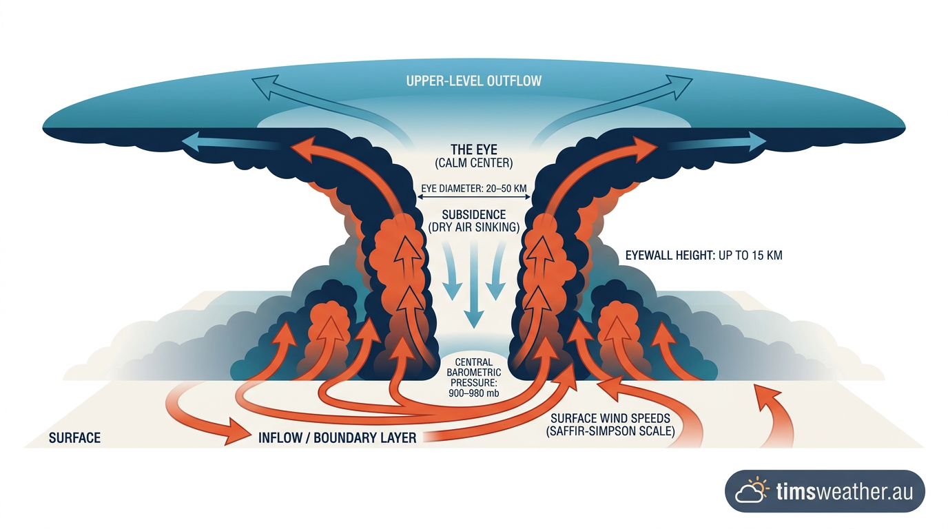
Angular momentum is the product of a rotating object's mass, velocity, and distance from the centre of rotation. Because momentum must be conserved in a closed system, air that is drawn inward toward the centre of the storm must spin faster as its radius decreases. This is the exact same mechanical principle that causes ice skaters to spin faster when they pull their arms inward during a pirouette. As the inward-rushing winds accelerate to violent speeds, they are influenced by both the initial Coriolis effect and the escalating centrifugal force.
products.climate.ncsu.edu notes in meteorological studies that as the air gets closer to the centre, the outward-directed centrifugal force becomes immense. Eventually, the inward-pulling pressure gradient force and the outward-pushing centrifugal force reach a state of equilibrium known as cyclostrophic balance. At this precise boundary, the air can simply go no further inward. Instead, this impenetrable wall of spinning wind is forced violently upward, creating the eyewall.
Subsiding air in a hurricane
Because the rising air inside the eyewall hits the boundary of the stratosphere at the top of the troposphere, it is forced to exhaust outward. However, a small portion of that upper-level air gets trapped and is forced downward into the calm centre. This subsiding air in a hurricane is the final, essential step in eye formation.
As the air sinks into the centre, it is compressed by the increasing atmospheric pressure closer to the ocean surface. This compression causes the air to warm rapidly, a process known as adiabatic warming. This warming lowers the relative humidity of the sinking air, effectively evaporating the clouds and resulting in a clear, central column of calm air.
Mapping the pressure gradient: From outer bands to the hurricane eye
The pressure field of a mature system is not uniform across its diameter, but rather resembles a steep bowl with a dramatic plunge near the inner core.
Atmospheric pressure and adiabatic warming
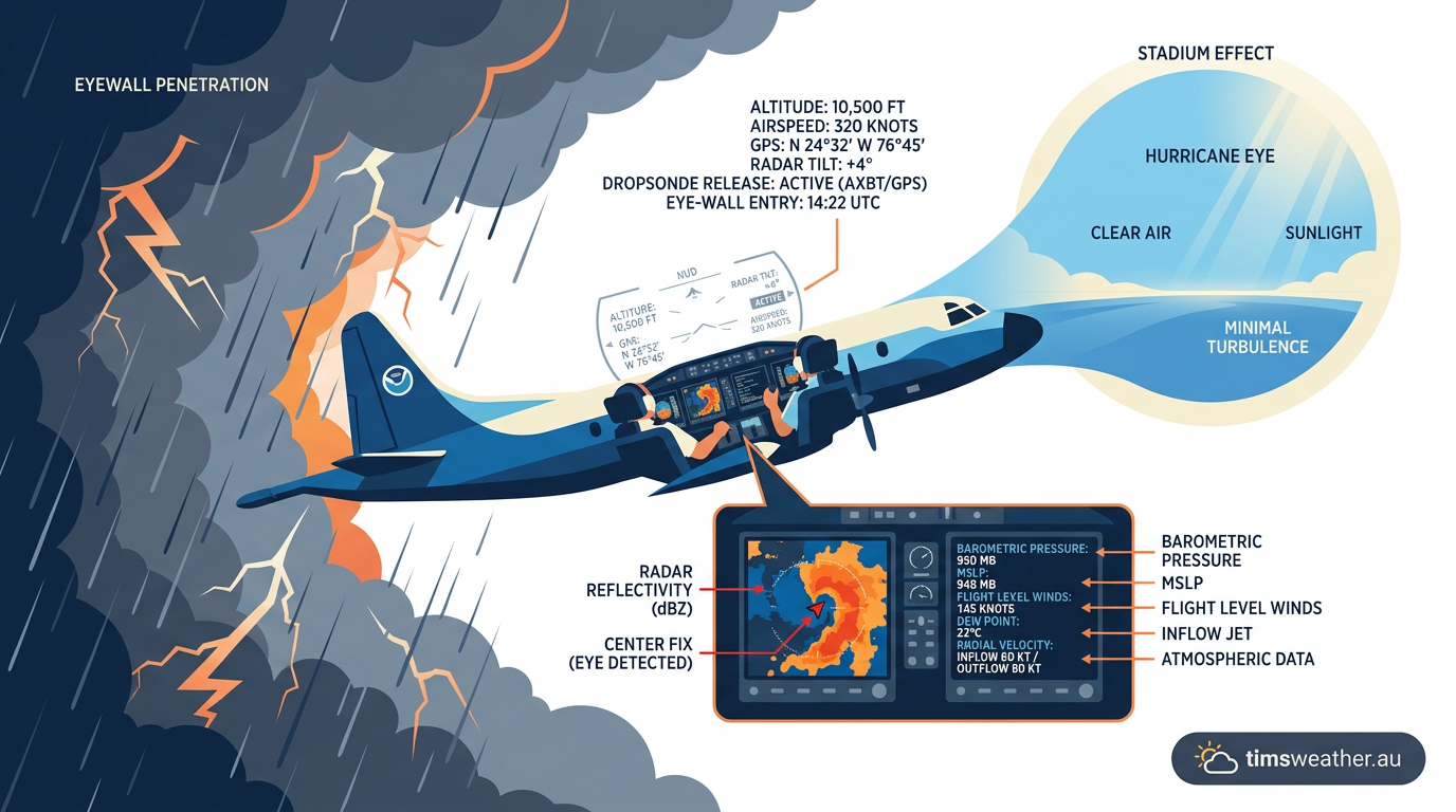
The extreme drop in barometric pressure is concentrated almost entirely within the final few kilometres approaching the centre. Measurements collected by NOAA Hurricane Research Division aircraft, known as Hurricane Hunters, confirm this extreme environment. When aircraft deploy instruments called dropsondes directly into a mature eye, they record rapid changes in temperature, humidity, and pressure. A recent post by www.facebook.com highlighted what it is like inside the eye of a major hurricane during these highly monitored flights.
During Hurricane Wilma in 2005 and Hurricane Gilbert in 1988, dropsonde data revealed central pressures dropping to 882 hPa and 888 hPa respectively. These historical readings demonstrate just how tightly wound the wind field becomes when the eye contracts during rapid intensification. The sinking air in the middle of the storm also creates a significant temperature anomaly. Cross-sectional diagrams published by the American Meteorological Society illustrate the structure as having a distinct "warm core". The air inside the eye can be up to 10 °C (18 °F) warmer than the air in the surrounding eyewall at the exact same altitude.
The thermodynamic engine: Why the hurricane eye stays cloud-free
Recent modelling from the Hurricane Forecast Improvement Program shows that the eye remains clear primarily because the downward motion creates a strong temperature inversion. This inversion acts as an atmospheric lid, preventing any new moisture from rising up from the ocean surface inside the eye. The physical mechanism is still described as a coupled vortex-convection problem. According to a www.facebook.com science group summary, one pathway is subsidence in the centre driven by the storm’s radial outflow, while another is that latent heat release in the eyewall forces compensating descent in the core.
Because the air is sinking and warming, convection is entirely suppressed in the very centre. This creates the stark visual contrast seen on satellite imagery: a ring of towering, violent thunderstorms surrounding a completely clear, calm centre. When sustained winds reach 119 km/h (74 mph), the system officially becomes a hurricane. At this intensity, the Saffir-Simpson Hurricane Wind Scale is used by agencies like the National Hurricane Center (NHC) and the National Oceanic and Atmospheric Administration (NOAA) to categorise the threat level.
Development Stage | Central Pressure | Eye Visibility | Primary Air Motion |
|---|---|---|---|
Tropical Disturbance | > 1005 hPa | None | Disorganised convection |
Tropical Depression | 1000–1005 hPa | None | Weak cyclonic rotation |
Tropical Storm | 990–1000 hPa | Cloud-filled centre | Organised inward flow |
Category 1–2 Hurricane | 965–990 hPa | Forming or obscured | Tight spiral, strong updrafts |
Category 3–5 Hurricane | < 965 hPa | Clear and defined | Intense eyewall updrafts, eye subsidence |
Breaking the balance: Dynamics of the eye wall replacement cycle
Hurricane dynamics are rarely stable for long periods, and the internal structure constantly shifts to manage the intake of thermal energy.
Expanding hurricane wind patterns

Once a major hurricane establishes a very tight, intense inner eye, a secondary ring of thunderstorms often begins to form further out from the centre. This marks the beginning of an eyewall replacement cycle, a process that dramatically alters the structure of the storm. As the outer ring of thunderstorms intensifies, it intercepts the warm, moist surface air that would normally feed the inner eyewall. Starved of its primary moisture supply, the inner eyewall begins to collapse. During this phase, the original eye fills with clouds, and the storm temporarily weakens as its central pressure rises.
Eventually, the new outer eyewall contracts and completely replaces the old one. Research covering the galaxbr.com structural dimensions of a storm notes that hurricane eyes typically span 32 to 64 km (20 to 40 miles) across, but observed eye size varies widely from about 8 to 190 km (5 to 120 miles). When the replacement cycle completes, the hurricane often emerges with a larger eye and a much broader wind field. This allows the storm to spread its extreme kinetic energy over a much wider geographic area.
The role of vertical wind shear in preventing hurricane eye formation
The fragile physical balance required for eye formation can be easily disrupted by external atmospheric forces. Vertical wind shear, which is a change in wind speed or direction with height, is highly detrimental to hurricane dynamics. If upper-level winds are too strong, they literally blow the tops off the convective towers.
This tilts the vertical axis of the storm. When the internal chimney is tilted, the latent heat release is dispersed over a wide area rather than being concentrated directly over the centre. Without that concentrated high-altitude warming, the central surface pressure cannot fall rapidly.
Consequently, the wind speeds remain lower, the centrifugal forces never reach critical levels, and the storm fails to force the creation of an eye. This is why you must consider wind shear when asking how do tropical depressions form and fail to develop further.
The reality of the calm interior
The stark visual contrast between the clear eye and the surrounding storm often leads to highly dangerous misconceptions regarding storm safety.
Does every hurricane have a clearly defined eye?
Not every system manages to hollow out a clear centre. Only highly organised storms typically display a distinct, clear eye on satellite imagery. The European Centre for Medium-Range Weather Forecasts (ECMWF) notes that powerful hurricanes can display a sharp, V-shaped eyewall in satellite imagery, reflecting highly organised convection around the core. Weaker systems, such as a strong tropical storm or a Category 1 hurricane, may only have a completely cloud-filled centre, sometimes referred to as an obscured eye.
Even in major hurricanes, the eye can sometimes be filled with low-level clouds, or it might become temporarily obscured during an eyewall replacement cycle. If you want to know how does the eye of a hurricane form in marginal environments, you must recognise that the structure is highly dynamic. If you explore how do tropical storms form, you will see that they often lack the intense cyclostrophic balance required to push the heavy cloud bands outward continuously.
Extreme kinetic energy in the eyewall
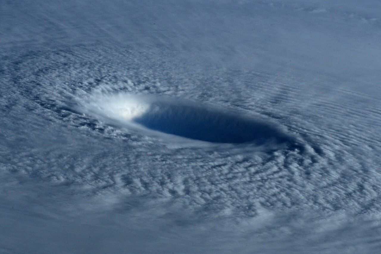
The extreme contrast between the calm interior and the violent exterior often leads to dangerous assumptions among the general public. The eye itself contains light winds, clear or partly cloudy skies, and sometimes visible stars at night. However, this deceptive calm is immediately surrounded by the most destructive portion of the storm. The eyewall contains the highest wind gusts, the heaviest rainfall, and the most extreme turbulence. The transition from the dead calm of the eye to the extreme kinetic energy of the eyewall is practically instantaneous.
Data detailing the descartesunderwriting.com economic impact of tropical cyclones highlights that this intense structural formation is responsible for billions of dollars in property damage annually. A community experiencing the direct passage of the eye will see winds drop to near zero, only for violent, hurricane-force winds to return suddenly from the opposite direction as the back half of the eyewall moves over the area. Also, www.nationalgeographic.com environmental reports reinforce that the extreme winds in the eyewall drive the ocean water ahead of the storm. This creates devastating storm surges along the coast, making the physical structure immediately surrounding the calm eye the deadliest and most destructive component of the entire hurricane system.
Last verified: 2026-09-16
Frequently asked questions
The eye forms when a cyclone’s innermost rainbands organise into a tight, circular ring of powerful thunderstorms known as the eyewall. This structure traps air in the centre, where it begins to sink. As this air descends, it warms and dries, effectively clearing the area of clouds and intense weather.
Source: aoml.noaa.gov
Further reading and resources
Explore trusted articles, books, videos and other resources to go deeper on this topic.
nesdis.noaa.govReference
A Guide to Understanding Satellite Images of Hurricanes - NESDIS
Background reference on How Does the Eye of a Hurricane Form? The Complete Meteorological Guide from nesdis.noaa.gov.
calcasieu.govReference
Hurricane Eye | Calcasieu Parish Police Jury, LA
Background reference on How Does the Eye of a Hurricane Form? The Complete Meteorological Guide from calcasieu.gov.
scied.ucar.eduReference
How Hurricanes Form - UCAR Center for Science Education
Background reference on How Does the Eye of a Hurricane Form? The Complete Meteorological Guide from scied.ucar.edu.
noaa.govReference
Tropical Cyclone Structure - NOAA
Background reference on How Does the Eye of a Hurricane Form? The Complete Meteorological Guide from noaa.gov.
Hurricanes | National Oceanic and Atmospheric Administration - NOAA
Background reference on How Does the Eye of a Hurricane Form? The Complete Meteorological Guide from noaa.gov.
hearttoheart.orgArticle
All You Need to Know About Hurricanes: A Complete Guide for ...
In-depth coverage on How Does the Eye of a Hurricane Form? The Complete Meteorological Guide from hearttoheart.org.
issnationallab.orgArticle
CyMISS Looks into the Eye of a Hurricane - ISS National Lab
In-depth coverage on How Does the Eye of a Hurricane Form? The Complete Meteorological Guide from issnationallab.org.
acurite.comArticle
The Eye of the Storm: How Do Hurricanes Form? - AcuRite
In-depth coverage on How Does the Eye of a Hurricane Form? The Complete Meteorological Guide from acurite.com.
en.wikipedia.orgReference
Eye (cyclone) - Wikipedia
Background reference on How Does the Eye of a Hurricane Form? The Complete Meteorological Guide from en.wikipedia.org.
youtube.comVideo
How is the eye of hurricane formed and maintained? - YouTube
Video coverage on How Does the Eye of a Hurricane Form? The Complete Meteorological Guide from youtube.com.
Planning weeks ahead?
Check Australia's long-range seasonal outlook for rainfall, temperature and the climate drivers (ENSO, IOD, SAM, MJO) shaping the next three months.
View Australia's Seasonal Weather Forecast