
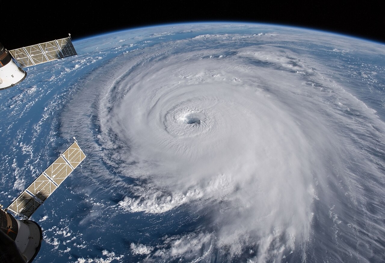
Tropical storms form through a process called cyclogenesis that requires warm ocean temperatures of at least 26.5 degrees Celsius, high humidity in the lower atmosphere, and low vertical wind shear. These conditions allow latent heat release to fuel convective thunderstorm clusters, which organize into rotating systems once the Coriolis effect initiates spin.
Key takeaways
A 60-metre depth of warm ocean is a key ingredient for understanding the atmospheric conditions for tropical storms.
Latent heat release acts as the primary atmospheric engine, powering deep convection and lowering central surface pressure.
The Coriolis effect provides the necessary spin, explaining why these systems rarely form within five degrees of the equator.
Low vertical wind shear allows the storm core to build vertically without being torn apart by high-altitude winds.
The connection between warm ocean temperatures and tropical storms ensures they decay rapidly upon moving over land.
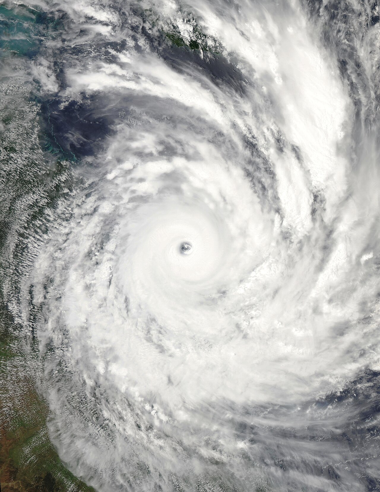
The atmospheric engine: tropical storm formation factors
When meteorologists study how do tropical storms form, they look for a specific set of atmospheric and oceanic ingredients working in perfect unison. Unlike weather fronts in colder climates, these tropical systems rely entirely on heat and moisture to build their structure.
Evaluating the tropical storm formation factors requires looking at the thermal properties of the ocean and the aerodynamic forces of the atmosphere. If any single ingredient is missing, the storm will fail to develop or rapidly dissipate back into a harmless cloud cluster.
Warm ocean temperatures and atmospheric moisture
The first mandatory ingredient establishing the atmospheric conditions for tropical storms is a warm sea surface. Atmospheric science research demonstrates that sea surface temperatures must reach a minimum of 27 degrees Celsius and extend to a depth of roughly 60 metres (www.youtube.com).
This deep reservoir of warmth ensures that as the storm's surface winds churn the ocean, they do not drag cold water up from the depths to extinguish the thermal energy supply. The low-pressure systems that trigger development rely entirely on this sustained heat source.
Beyond warm water, the surrounding atmosphere must be rich in moisture from the surface up to the mid-troposphere. Dry air entering a developing storm causes evaporation, which cools the air and produces heavy, sinking downdrafts that choke off rising convective currents. A thoroughly moist atmosphere prevents this dry air entrainment, allowing continuous thunderstorm activity to coalesce and the pressure gradient to steepen rapidly.
The role of Convective Available Potential Energy (CAPE)
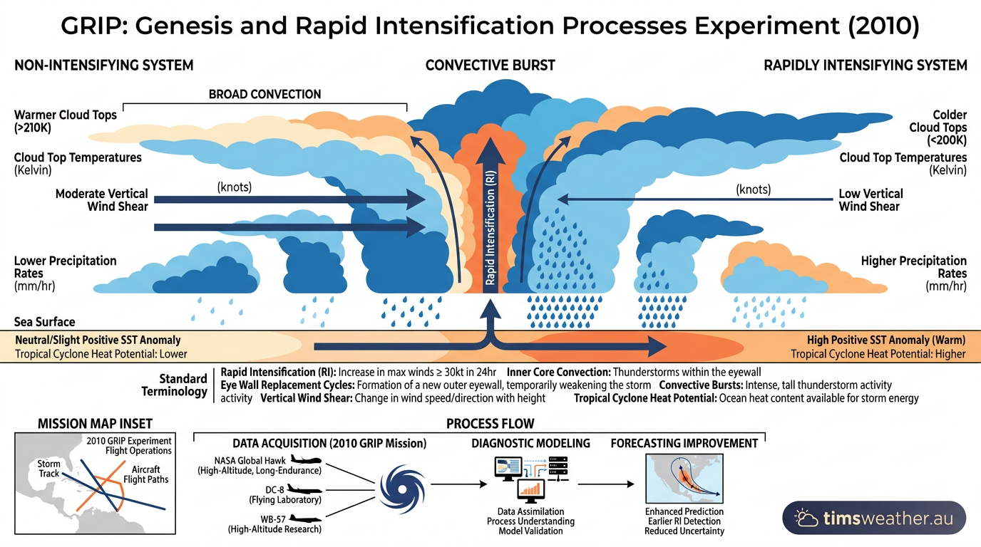
Meteorologists use Convective Available Potential Energy to measure atmospheric instability, which dictates how fast air can rise. High levels of this energy are essential for deep convection.
When the ocean surface is very warm and humid and the upper atmosphere is relatively cold, the atmosphere becomes highly unstable. This steep temperature lapse rate causes parcels of surface air to accelerate upwards, punching through the troposphere to heights exceeding 15 kilometres.
In the tropics, this rapid upward motion creates massive clusters of cumulus clouds that act as the structural building blocks for tropical storm cyclogenesis. Without sufficient instability, rising air parcels will hit a stable temperature layer and spread out too early, completely halting the vertical development necessary for a severe weather system to take shape.
The role of the Coriolis effect and angular momentum
The rotation of the Earth deflects moving air across the surface, an aerodynamic phenomenon known as the Coriolis effect. As air rushes inward toward a developing low-pressure centre, this deflection forces the winds into a counter-clockwise spiral in the Northern Hemisphere and a clockwise spiral in the Southern Hemisphere. Because this rotational force is virtually zero at the equator, cyclogenesis requires a minimum latitude of about 5 degrees to initiate rotation (www.savemyexams.com).
As the converging air spirals tighter around the storm's centre, the conservation of angular momentum dictates that the wind speed must increase rapidly. This mechanism works exactly like a figure skater pulling their arms inward to spin much faster on the ice. Without this rotational force provided by the Earth, incoming air would simply fill the low-pressure void directly, equalising the pressure and preventing any storm from forming.
Ingredient | Threshold Requirement | Role in Tropical Storms |
|---|---|---|
Sea Surface Temperature | Minimum 26.5°C to 60m depth | Provides thermal energy and moisture to fuel the lower atmosphere. |
Coriolis Effect | Formation beyond 5° latitude | Initiates the rotational spin required to organise the system. |
Vertical Wind Shear | Less than 10 metres per second | Allows the storm core to build vertically without being torn apart. |
Atmospheric Moisture | High mid-troposphere humidity | Prevents dry air entrainment from evaporating clouds and creating downdrafts. |
How do tropical storms form: the lifecycle milestones
The entire tropical storm development process follows a predictable sequence of meteorological milestones. While the ocean may possess all the necessary thermal energy, the atmosphere must slowly organise that chaotic energy into a structured, rotating machine. Tracking these milestones allows meteorologists from agencies like the World Meteorological Organization and the National Hurricane Center to issue timely, accurate warnings for maritime traffic and coastal communities.
From tropical disturbance to tropical depression
Every system begins as a pre-existing weather disturbance, such as a loose cluster of unorganised thunderstorms drifting along a tropical wave. At this initial stage, there is no closed circulation or defined central eye. If atmospheric conditions remain favourable and sea surface temperatures are sufficient, the surface pressure drops and a defined centre of circulation finally forms.
This transition marks the birth of a tropical depression. At this point, the system has maximum sustained surface winds below 63 km/h (34 knots). Historical data proves that only a small fraction of oceanic disturbances manage to reach this closed-circulation milestone, requiring an exact alignment of weak shear and deep moisture (products.climate.ncsu.edu). You can study this specific early phase by reading about how do tropical depressions form.
Transitioning into mature systems
If the depression remains over warm water and experiences favourable conditions aloft, the intensification phase accelerates drastically. Sustained winds increase as the pressure gradient tightens, and the central barometric pressure drops steadily. When winds reach between 63 km/h and 118 km/h, the system officially becomes a tropical storm. At this stage, regional monitoring agencies assign a name from an established alphabetical list to streamline public warnings.
Once sustained winds exceed 119 km/h (64 knots), the system transitions out of the storm classification and becomes a severe tropical cyclone, hurricane, or typhoon, depending solely on the specific ocean basin in which it resides.
The World Meteorological Organization outlines these exact wind speed thresholds in Technical Document No. 49, ensuring global forecasting consistency. If you want to know what happens at the highest intensity levels, explore how do hurricanes form to view the severe end of the scale.
Why vertical wind shear disrupts tropical storm development
Even with boiling ocean temperatures and immense moisture, a developing system will fail if vertical wind shear is too high. Wind shear refers to the change in wind speed and direction at different altitudes in the atmosphere. Because tropical systems act as vertical heat cylinders, their thunderstorms must remain stacked directly over the surface low-pressure centre to function efficiently.
When strong upper-level winds blow across the top of a developing storm, they tilt the convective tower. This tilting forces the latent heat to be released away from the surface centre, causing the central pressure to rise and the wind field to weaken. This is why strong jet streams often act as a protective barrier, tearing apart storms before they can reach maturity.
Latent heat release: the anatomy of tropical storms
To fully grasp cyclogenesis, meteorologists view these weather systems as massive, naturally occurring heat engines. The thermodynamic engine theory, established by atmospheric scientist Kerry Emanuel, compares the anatomy of tropical storms to a classic Carnot cycle.
The storm extracts heat energy from the warm ocean surface through steady evaporation. As this moist air spirals inward and rises, it expands and cools, releasing kinetic energy as wind before rejecting the spent air into the freezing upper atmosphere near the tropopause.
The physics of evaporation and condensation
Water possesses a remarkably high specific heat capacity. When intense sunlight hits the tropical ocean, the surface water absorbs massive amounts of solar radiation. A portion of this water evaporates, transforming from a liquid into an invisible gas known as water vapour. This important phase change stores the sun's energy within the water vapour molecules as latent heat.
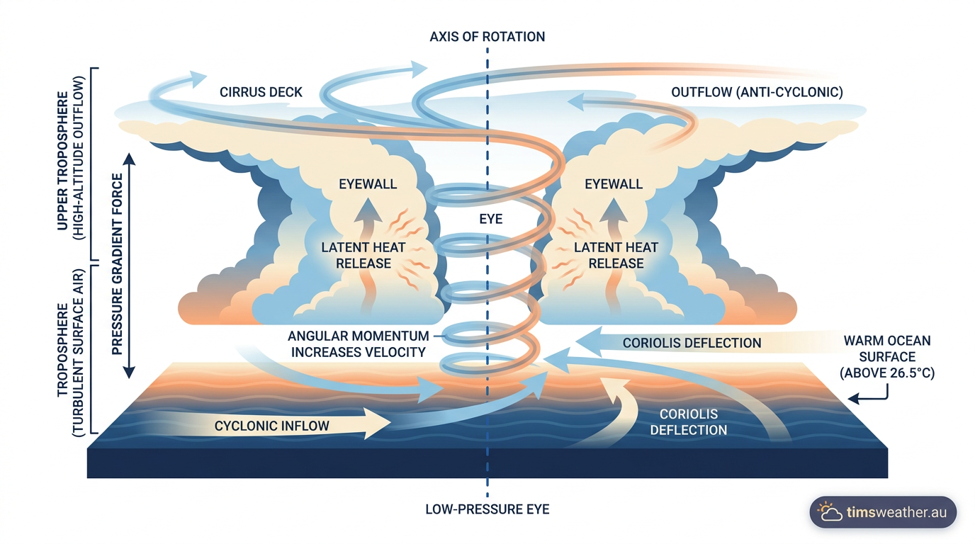
When this saturated air is drawn into the low-pressure centre of a developing storm and forced upward into the colder troposphere, it cools. The cooling forces the water vapour to condense back into liquid droplets, creating torrential rain. As the water changes back to liquid, it releases its stored heat energy into the surrounding atmosphere. This warms the air aloft, making it lighter and causing it to rise even faster. The surface pressure drops further in response, sucking in more moisture-laden air in a continuous, self-sustaining loop.

Low-level convergence and upper-level outflow
A developing storm requires a perfectly balanced airflow system to survive its rapid growth phase. Low-level convergence describes the process of surface winds spiralling inward toward the centre, gathering fresh moisture and heat from the ocean surface. However, if this incoming air has nowhere to go once it rises up through the eyewall, the central pressure will rise, and the storm will quickly suffocate under its own atmospheric weight.
Upper-level outflow solves this thermodynamic problem completely. High above the storm, near the tropopause, winds must spiral outward in a divergent anticyclonic pattern. This high-altitude exhaust system vents the spent air away from the storm centre efficiently, allowing surface pressures to plummet and winds to intensify further. When upper-level divergence is strong, rapid tropical storm intensification often follows.
Tropical storm intensification and vulnerability
As the heat engine becomes more efficient, the storm core tightens and an eye begins to clear out in the centre, surrounded by the towering thunderstorms of the eyewall. This structural maturity signifies peak intensification. The resulting wind field and massive storm surges present extreme danger to coastal communities.
Global humanitarian data shows that severe weather events driven by rapid cyclogenesis pose heavy threats to populated coastlines; for example, countries like the Philippines and Madagascar frequently encounter these severe storms due to their geographic placement within prime warm-water genesis zones (www.savethechildren.org.uk).
Where do tropical storms typically form?
The connection between warm ocean temperatures and tropical storms restricts these massive systems to specific latitude bands. They very rarely form poleward of 30 degrees latitude because the sea surface temperatures are simply too cold to support the latent heat phase changes required. Similarly, they almost never form within five degrees of the equator because the Coriolis effect is too weak to provide the necessary rotational spin.
Global distribution and basin terminology
While the physics of cyclogenesis are identical globally, regional terminology differs based strictly on where the system develops. They are referred to as hurricanes in the North Atlantic and eastern North Pacific, typhoons in the western North Pacific, and cyclones in the South Pacific and Indian Ocean basins (descartesunderwriting.com).
The World Meteorological Organization notes that approximately 85 tropical storms form each year globally, with roughly 72 percent occurring in the Northern Hemisphere where larger expanses of warm water exist north of the equator during the peak summer months.
The Intertropical Convergence Zone (ITCZ)
Many systems trace their atmospheric origins directly to the Intertropical Convergence Zone. This is a semi-permanent global band of low pressure near the equator where the northeast and southeast trade winds collide. The physical collision of these massive air currents forces air upwards, generating persistent, messy clusters of thunderstorms.
During the summer and autumn months, the ITCZ often migrates away from the equator into higher latitudes where the Coriolis effect is much stronger. Disturbances breaking off from this active convergence zone often serve as the initial atmospheric spark for cyclogenesis, providing the pre-existing low-level spin needed to gather convection together.
African Easterly Waves in the Atlantic
In the North Atlantic basin, a significant percentage of severe systems originate from African Easterly Waves. These are atmospheric pressure ripples that travel from east to west off the western coast of the African continent. The waves are generated by the intense temperature contrast between the extremely hot, dry air over the Sahara Desert and the cooler, humid air mass sitting over the Gulf of Guinea.
As these pressure waves track across the open Atlantic Ocean, they provide the initial lift required to spark deep convection. Exploring how squall line formation occurs helps explain how these initial clusters of thunderstorms arrange themselves along the wave axis before eventually closing off their circulation into a defined depression.
Forecasting the tropical storm development process
Predicting exactly when and where a tropical storm will form remains one of the hardest challenges in operational meteorology. The oceans are vast, and data gathering relies heavily on satellite imagery rather than direct surface observation. Forecasters must carefully monitor both the ocean temperatures below and the shifting wind currents high in the upper atmosphere to predict the moment of cyclogenesis.
Ensemble modelling and early detection
Meteorologists rely heavily on ensemble modelling to assess the mathematical probability of cyclogenesis over a given week. Instead of running a single weather model, agencies run the exact same global models dozens of times with slightly altered starting conditions. By comparing the European Centre for Medium-Range Weather Forecasts (ECMWF) model against the Global Forecast System (GFS), meteorologists can evaluate the probability of a system developing days before a closed circulation actually forms. If a high percentage of ensemble members show a depression forming over a specific region, forecasters gain the confidence required to issue early advisories.
The role of Regional Specialized Meteorological Centres
The World Meteorological Organization coordinates this global forecasting effort through Regional Specialized Meteorological Centres (RSMCs). Agencies like the National Hurricane Center in Miami monitor the Atlantic and eastern Pacific, while the Japan Meteorological Agency tracks developments in the western North Pacific.
These centres share satellite data, radar imagery, and aircraft reconnaissance information internationally. This cooperation ensures that maritime vessels and coastal authorities receive standardised, scientifically grounded warnings regardless of which ocean basin a system threatens.
How global climate oscillations impact tropical storm formation frequencies
The broader state of the global climate heavily influences the tropical storm development process from year to year. Massive shifts in ocean temperatures and trade winds dictate where these systems can find the exact atmospheric conditions required to build their internal structure.
The El Niño-Southern Oscillation (ENSO) influence
During an El Niño phase, ocean temperatures in the central and eastern equatorial Pacific become unusually warm. This shift completely alters global wind patterns. In the Atlantic basin, El Niño increases vertical wind shear across the Caribbean Sea and the main development region.
This hostile wind shear tears developing convective clusters apart before they can establish a low-pressure centre, which often keeps the Atlantic hurricane season historically calm (www.kpax.com). Conversely, this same pattern reduces wind shear in the eastern and central Pacific, leading to highly active seasons in those regions.
The impact of La Niña
When the cycle flips to a La Niña phase, the opposite atmospheric conditions for tropical storms occur. The Pacific waters cool, which shifts the strongest thunderstorm activity westward toward Indonesia. For the Atlantic basin, La Niña significantly reduces vertical wind shear and increases atmospheric instability.
If you want to know what triggers these broader climate shifts, read about how does La Niña form. Under these favourable conditions, a higher percentage of tropical disturbances survive the journey across the ocean, leading to intense cyclogenesis and highly destructive storm seasons.
Last verified: 2026-09-14
Frequently asked questions
Tropical storms develop when warm ocean water heats the moist air above it. This warm air rises, creating a low-pressure area. As more air rushes in, thunderstorms build and begin to spin, eventually organising into a powerful weather system powered by the heat energy from the ocean surface.
Source: bom.gov.au
Further reading and resources
Explore trusted articles, books, videos and other resources to go deeper on this topic.
weather.govReference
Tropical Definitions - National Weather Service
Background reference on How Do Tropical Storms Form? The Complete Meteorological Guide from weather.gov.
youtube.comVideo
Understanding tropical cyclones - YouTube
Video coverage on How Do Tropical Storms Form? The Complete Meteorological Guide from youtube.com.
emergency.fsu.eduReference
Tropical Storms & Hurricanes: The Basics - Emergency Management
Background reference on How Do Tropical Storms Form? The Complete Meteorological Guide from emergency.fsu.edu.
noaa.govReference
Hurricanes | National Oceanic and Atmospheric Administration - NOAA
Background reference on How Do Tropical Storms Form? The Complete Meteorological Guide from noaa.gov.
spaceplace.nasa.govReference
How Do Hurricanes Form? | NASA Space Place – NASA Science for Kids
Background reference on How Do Tropical Storms Form? The Complete Meteorological Guide from spaceplace.nasa.gov.
dickinsontexas.govReference
Science of Storms | Dickinson, TX - Official Website
Background reference on How Do Tropical Storms Form? The Complete Meteorological Guide from dickinsontexas.gov.
ametsoc.orgArticle
Tropical Cyclone Forecasting in the United States
In-depth coverage on How Do Tropical Storms Form? The Complete Meteorological Guide from ametsoc.org.
bbc.co.ukArticle
The formation of tropical storms guide for KS3 geography students - BBC
In-depth coverage on How Do Tropical Storms Form? The Complete Meteorological Guide from bbc.co.uk.
en.wikipedia.orgReference
Tropical cyclone - Wikipedia
Background reference on How Do Tropical Storms Form? The Complete Meteorological Guide from en.wikipedia.org.
oceanservice.noaa.govReference
How do hurricanes form? - NOAA's National Ocean Service
Background reference on How Do Tropical Storms Form? The Complete Meteorological Guide from oceanservice.noaa.gov.
Planning weeks ahead?
Check Australia's long-range seasonal outlook for rainfall, temperature and the climate drivers (ENSO, IOD, SAM, MJO) shaping the next three months.
View Australia's Seasonal Weather Forecast