
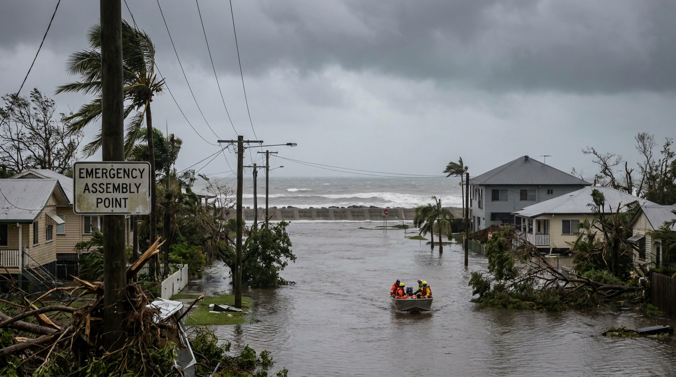
Hurricane categories simply refer to the Saffir-Simpson Hurricane Wind Scale, which rates storms from 1 to 5 based on their maximum sustained wind speeds. This system helps meteorologists estimate potential property damage, with Category 1 causing minimal structural impact and Category 5 bringing catastrophic, widespread destruction to coastal areas.
Key takeaways
The Saffir-Simpson scale classifies hurricane intensity using maximum sustained wind speeds averaged over a one-minute period.
Storms reaching Category 3, 4, or 5 are officially designated as major hurricanes due to their severe potential for structural failure.
The category rating relies exclusively on wind speed and does not account for life-threatening storm surge or inland freshwater flooding.
A large, slow-moving lower-category storm can sometimes cause more overall destruction than a compact higher-category storm.
Meteorologists regularly re-evaluate and adjust a hurricane's official category during post-season analysis after examining all available global weather data.
Hurricane categories explained: The Saffir-Simpson scale
How are hurricane categories explained?
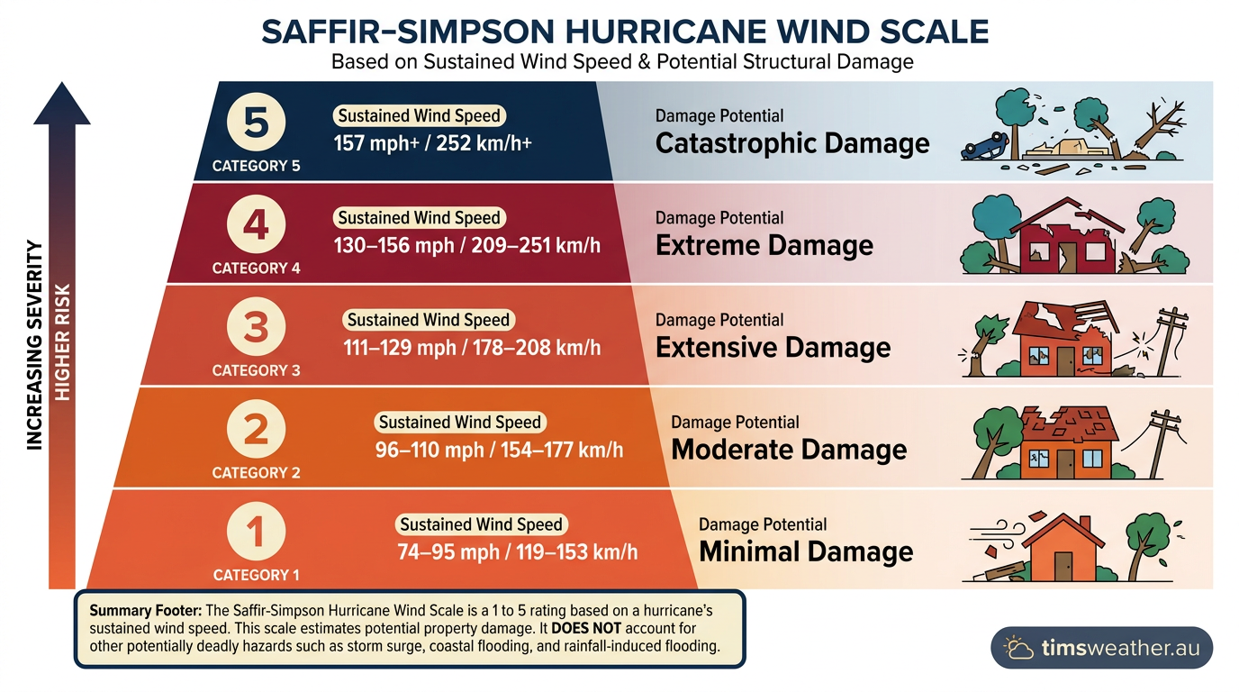
Hurricane categories explained through the Saffir-Simpson Hurricane Wind Scale use a 1 to 5 rating based on sustained wind speeds. This scale estimates potential property damage, with Category 1 being the least intense and Category 5 representing the most catastrophic hurricane wind damage, though it does not explicitly account for storm surge or rainfall flooding.
The history of the wind scale
The system used to classify these massive tropical cyclones was developed in 1971 by civil engineer Herbert Saffir and meteorologist Robert Simpson, who was serving as the director of the National Hurricane Center at the time. Prior to this innovation, meteorologists lacked a standardised method for communicating the specific structural dangers of an approaching storm to emergency managers and the general public. As detailed by Britannica, the scale provides a clear framework to help officials assess risk and order necessary evacuations based strictly on expected wind damage.
The scale applies strictly to systems in the Atlantic Ocean and the Eastern Pacific. Other basins use different terminology and measurement criteria. For instance, the World Meteorological Organization notes that while the physics of the storms are identical, the naming conventions shift to "typhoons" in the western North Pacific and "tropical cyclones" across the Indian Ocean and South Pacific. Regardless of the basin, understanding these hurricane intensity levels is essential for community survival.
Hurricane Category 1: Minimal damage potential
What is the difference between a tropical storm and a category 1 hurricane?
The primary difference between a tropical storm and a Category 1 hurricane is the maximum sustained wind speed. A tropical storm features sustained winds between 63 km/h and 118 km/h (39 to 73 mph). Once those winds reach a sustained 119 km/h (74 mph), the system is officially upgraded to a Category 1 hurricane, signalling a higher potential for structural damage.
Wind speed and structural impact
While Category 1 is the lowest tier on the Saffir-Simpson scale, the wind load placed on residential structures is still severe. The winds blow continuously between 119 km/h and 153 km/h (74 to 95 mph), with even stronger transient gusts occurring within the intense outer rainbands. At this level of hurricane intensity, well-constructed permanent homes generally remain intact but face a high risk of losing roof shingles, vinyl siding, and aluminium gutters.
High-speed winds wrap around structures, creating areas of negative pressure that aggressively lift flat surfaces. According to the Asbury Park Press, older unanchored mobile homes are especially vulnerable to being pushed completely off their foundations or suffering catastrophic siding damage, even at these baseline hurricane wind speeds. Protective measures must be taken well before these wind speeds arrive.
Power grid and tree vulnerabilities
The primary threat during a Category 1 event often comes from falling debris rather than direct structural failure. Large branches easily snap off older trees, and shallow-rooted trees sitting in rain-saturated soil frequently topple over. This falling timber brings down utility poles and essential power lines, resulting in local electrical outages that can take several days to repair. For coastal residents, understanding how do tropical storms form and eventually intensify into these Category 1 systems is an essential part of seasonal preparation.
Hurricane Category 2: Moderate structural impact
The physics of increased wind pressure
When maximum sustained winds increase to between 154 km/h and 177 km/h (96 to 110 mph), the system is classified as a Category 2 hurricane. The jump from Category 1 to Category 2 represents a massive escalation in damage potential due to the fluid dynamics of wind pressure. The force exerted by wind against a solid, flat surface increases exponentially with the square of the wind velocity. Consequently, a small numerical increase in wind speed translates into a massive surge in destructive kinetic energy.
Roof and window failure risks
Extensive property damage is expected when a Category 2 hurricane makes landfall. Well-constructed homes face a high probability of sustaining major roof decking and external cladding damage. Strong, sustained winds can easily lift overlapping roof tiles, tear away large sections of tar paper, and compromise the structural integrity of the roof itself. Windows that are not protected by impact-resistant glass or heavy-duty storm shutters may shatter under the immense atmospheric pressure or from airborne debris thrown by the storm.
Power outages and road blockages
The impact on local infrastructure is significant. Near-total power loss is common in communities experiencing the direct eyewall of a Category 2 storm, and these outages can easily stretch from several days to a few weeks. The high winds will snap numerous large trees and uproot countless others, effectively blocking major evacuation routes and preventing emergency services from safely working through the affected region. General weather safety materials, such as an educational video explainer on hurricane wind speeds, frequently highlight Category 2 as the threshold where temporary shelters begin to fail.
Hurricane Category 3: The threshold for a major hurricane
What defines a major hurricane according to wind speed?
A major hurricane is defined as any tropical cyclone that reaches Category 3, 4, or 5 on the Saffir-Simpson scale. This official classification requires maximum sustained wind speeds of at least 178 km/h (111 mph). Meteorologists use this designation because historical data proves that winds at or above this speed cause an exponentially higher amount of catastrophic structural damage compared to weaker storms.
Why the major hurricane designation matters
A hurricane reaches Category 3 status when its sustained winds climb to between 178 km/h and 208 km/h (111 to 129 mph). Crossing this specific numerical threshold triggers the "major hurricane classification" used globally by warning agencies. The NOAA AOML highlights this threshold because the damage profile shifts dramatically; while lower-tier storms primarily damage external cladding and natural features, a Category 3 system begins to tear at the deep structural framing of residential buildings.
Widespread structural failure
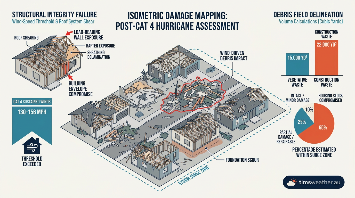
Devastating damage occurs routinely at this tier. Sturdy, well-built residential homes often suffer major damage to roof decking, and entire gable ends frequently fail under the sustained wind load. When a roof's integrity is breached in this manner, the sudden, violent change in internal house pressure can cause a partial wall collapse. Older homes, or structures lacking modern hurricane strapping that connects the roof trusses directly to the foundation walls, are highly vulnerable to complete structural destruction.
Infrastructure isolation and recovery time
Infrastructure disruption reaches critical levels during a Category 3 strike. Municipal water filtration systems and regional electricity grids are typically unavailable for several days to weeks after the storm passes. The sheer volume of uprooted trees and snapped high-voltage utility poles guarantees that residential neighbourhoods will be isolated from immediate rescue and recovery efforts.
Hurricane Category 4: Devastating wind speeds and severe impacts
Catastrophic failure of framed housing
Category 4 hurricanes possess extreme sustained wind speeds ranging from 209 km/h to 251 km/h (130 to 156 mph). These weather events are exceptionally dangerous and historically responsible for flattening entire coastal communities. During a Category 4 event, well-built framed homes can lose most of their roof structure and experience the collapse of load-bearing exterior walls. Mobile homes, regardless of how securely they are anchored to the ground, are usually completely obliterated by the intense wind pressure and heavy airborne debris.
Grid destruction and habitability
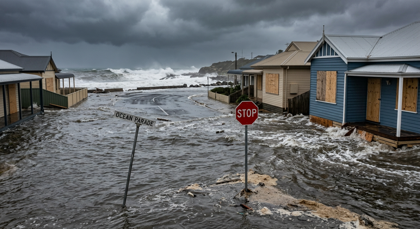
Trees are snapped or uprooted in massive numbers, completely stripping the sector of nearly all natural vegetation. The power grid in the direct path of the hurricane eyewall is often completely destroyed rather than merely damaged, necessitating a ground-up rebuild of electrical infrastructure that can take months. Coastal areas struck directly by a Category 4 storm remain highly dangerous and uninhabitable for weeks while basic civil services are slowly restored.
The role of storm structure in wide-scale damage
A major storm operating at this terrifying level often undergoes an eyewall replacement cycle, a meteorological process that can temporarily fluctuate its peak intensity but ultimately expands the total wind field. This structural change spreads severe, Category 4 wind damage over a much wider geographic area, multiplying the financial cost and necessary recovery time for the affected state.
Hurricane Category 5: Catastrophic outcomes and historical examples
The atmospheric limits of hurricane intensity
The highest tier on the Saffir-Simpson Hurricane Wind Scale is Category 5. A storm receives this classification when its maximum sustained winds reach or exceed a staggering 252 km/h (157 mph). Because the scale is open-ended, there is no upper limit to this category. Category 5 storms represent the absolute extreme of atmospheric potential, requiring near-perfect environmental conditions to form and maintain their strength.
Analysing how do hurricanes form in such ideal conditions reveals that they require intensely hot ocean water extending deep below the surface, a highly saturated atmosphere, and virtually zero vertical wind shear. Without these perfect conditions, the delicate thermal engine of a Category 5 system will rapidly degrade.
Total structural failure
The expected damage potential of a Category 5 hurricane is absolute. A high percentage of framed homes will be completely destroyed, experiencing total roof failure and immediate wall collapse. Even commercial buildings constructed from reinforced masonry can suffer severe structural damage, particularly to large roof spans over warehouses, industrial parks, or supermarkets. All trees and power poles in the direct path will be snapped or violently uprooted, and fallen high-voltage lines will make streets utterly impassable.
The historical record of Category 5 landfalls
These catastrophic storms are incredibly rare, but their impacts permanently alter coastlines. Hurricane Andrew (1992) levelled entire subdivisions in South Florida with wind speeds that pushed the limits of the scale, subsequently forcing a rewrite of state building codes. Hurricane Dorian (2019) stalled completely over the northern Bahamas as a Category 5 system, subjecting the small islands to prolonged extreme winds that virtually erased entire towns. Reviewing the Wikipedia record of Atlantic Category 5 storms highlights just how few systems manage to achieve and sustain this peak intensity prior to making landfall.
Hurricane Category | Sustained Winds (km/h) | Sustained Winds (mph) | Expected Damage Potential |
|---|---|---|---|
Category 1 | 119 to 153 | 74 to 95 | Minimal damage to well-built homes. Tree branches snapped. |
Category 2 | 154 to 177 | 96 to 110 | Extensive damage to roofs and siding. Many trees uprooted. |
Category 3 (Major) | 178 to 208 | 111 to 129 | Devastating damage. Roof decking removed, walls compromised. |
Category 4 (Major) | 209 to 251 | 130 to 156 | Catastrophic structural failure. Complete roof loss common. |
Category 5 (Major) | 252 or higher | 157 or higher | Total destruction of framed homes. Complete infrastructure loss. |
Beyond wind speed: Why Saffir-Simpson doesn't predict hurricane storm surge
Why does a hurricane category not measure storm surge risk?
A hurricane category does not measure storm surge risk because the Saffir-Simpson scale is based entirely on maximum sustained wind speed. It does not account for the physical size of the storm, its forward motion, or the underwater topography of the coastline. A massive Category 2 storm can push significantly more ocean water inland than a compact Category 4 storm.

The limitation of a wind-only metric
The most dangerous public misconception regarding hurricane categories is the firm belief that the number on the scale represents the total overall threat. The Saffir-Simpson system is exclusively a wind scale. It does not measure or attempt to predict the deadly phenomenon known as storm surge, nor does it account for torrential rainfall or inland flooding potential. Storm surge is an abnormal, rapid rise of ocean water generated by a storm's winds pushing water toward the shore, over and above the predicted astronomical tide.
Variables that drive deadly storm surge
Storm surge is heavily influenced by the physical size of the hurricane wind field, its forward speed, the angle at which it approaches the coast, and the underwater topography (bathymetry) of the continental shelf. As noted in a detailed analysis by Team Rubicon, a massive but relatively weak Category 2 storm pushing water over a wide, shallow offshore shelf will generate a much higher and deadlier surge than a very compact Category 4 storm striking a coast with a steep ocean drop-off.
Relying solely on the wind category to dictate evacuation plans can be a fatal mistake for coastal residents. The National Hurricane Center explicitly warns that water, not wind, is responsible for the vast majority of hurricane-related fatalities. Flooding from storm surge and extreme freshwater rainfall accounts for nearly 90 percent of all deaths during tropical cyclones. Therefore, emergency managers continually emphasise that residents must separate their wind risk from their water risk when viewing public advisories.
The danger of 'major hurricane' status: Understanding compound hazards
Torrential rainfall and freshwater flooding
When meteorologists classify a system as a major hurricane, they are signalling an exponential increase in the threat to life and property. The danger of 'major hurricane' status lies in compound hazards. A storm packing winds over 178 km/h (111 mph) is rarely just a wind event. These intense systems usually feature incredibly low barometric pressure, deeply structured convective rainbands, and a massive circulation field capable of disrupting the ocean surface hundreds of kilometres away.
As these high-category storms approach land, they push a wall of water ahead of them while simultaneously dropping hundreds of millimetres of rain far inland. The intense onshore wind prevents water from draining out of rivers and estuaries, causing severe backwater flooding. This means residents are frequently subjected to structural wind failure at the exact moment rising water compromises their foundation. This violent intersection of hazards makes surviving a direct hit from a major hurricane extremely difficult without a prior evacuation plan.
Tornado threats in outer rainbands
The intense atmospheric convection within the core of a major storm also spawns numerous fast-moving tornadoes in the outer rainbands. These short-lived but highly violent tornadoes add localised zones of extreme destruction well away from the actual centre of the storm. Observing how does the eye of a hurricane form and tighten on satellite imagery serves as a clear warning to meteorologists that a system has used enough energy to deploy these compound hazards simultaneously upon landfall.
How meteorologists calculate maximum sustained winds
Aircraft reconnaissance and dropsonde technology
Assigning a precise category to a hurricane requires accurate measurement of its strongest winds. Meteorologists define maximum sustained winds as the highest one-minute average wind speed found anywhere within the storm at a standard elevation of 10 metres. Because the absolute strongest winds are tightly concentrated in the eyewall, capturing this exact measurement while a storm is spinning over the open ocean requires advanced technology and aviation expertise.
The most critical data comes directly from aircraft reconnaissance. Specially equipped planes, commonly known as Hurricane Hunters, fly directly into the violently turbulent core of the storm. While traversing the eyewall, these crews deploy cylindrical instruments called dropsondes. Parachuting down to the turbulent ocean surface, the dropsonde continuously transmits barometric pressure, temperature, humidity, and GPS-calculated wind speed back to the aircraft. According to technical explainers from 13NewsNow, this direct sampling is the only guaranteed way to verify if a storm has crossed the threshold into the next category.
Satellite estimates and radar velocity
When aircraft are unavailable, or the storm is outside of flight range, meteorologists rely on advanced satellite imagery to estimate wind speeds using the Dvorak technique. This method analyses the cloud patterns and the temperature differences between the warm eye and the cold cloud tops to assign an intensity estimate. Once a storm nears the coast, Doppler radar takes over, providing high-resolution wind velocity data that helps forecasters pinpoint exactly when and where the worst wind damage will occur. How how do tropical depressions form and slowly organise into these massive radar signatures helps forecasters track the entire life cycle of the storm.
Why hurricane intensity levels are re-evaluated post-landfall
The post-season analysis phase
It is highly common for a hurricane's official category to change months after the storm has completely dissipated. During the active phase of a storm, forecasters operate under extreme pressure, using real-time data to issue immediate public warnings. However, once the Atlantic or Eastern Pacific hurricane season concludes, specialists at the National Hurricane Center undertake a painstaking post-season analysis of every single tropical cyclone.
Adjusting categories for historical records
During this review process, meteorologists examine every piece of available global weather data, including delayed ship reports, satellite scatterometer data, offshore buoy recordings, and ground-level damage surveys. If the forensic evidence shows that the winds were stronger or weaker than initially estimated during the operational phase, the agency will officially adjust the peak intensity and category rating. A comprehensive overview from AOL confirms that these careful post-storm adjustments are essential for maintaining accurate historical climate records and improving future forecasting models. Much like understanding how do low-pressure systems form and evolve over decades, having a perfectly accurate database of historical hurricane categories ensures that structural engineers know exactly what wind loads future buildings must withstand.
Sources
Saffir-Simpson Hurricane Wind Scale (nhc.noaa.gov)
NOAA weather and atmospheric science reference (nhc.noaa.gov)
NOAA weather and atmospheric science reference (aoml.noaa.gov)
NOAA weather and atmospheric science reference (nhc.noaa.gov)
"Saffir-Simpson Hurricane Scale" (aoml.noaa.gov)
Post-Tropical Cyclone Lowell Public Advisory (nhc.noaa.gov)
Hurricane Karina Public Advisory (nhc.noaa.gov)
NOAA weather and atmospheric science reference (nhc.noaa.gov)
Last verified: 2026-09-19
Frequently asked questions
Hurricane categories signify the intensity of sustained wind speeds within a tropical cyclone, utilising a scale from 1 to 5. Higher categories reflect increasing wind strength and a greater potential for severe damage. Storms classified as Category 3 or above are formally designated as major hurricanes.
Source: aoml.noaa.gov
Further reading and resources
Explore trusted articles, books, videos and other resources to go deeper on this topic.
bkvenergy.comArticle
Hurricane categories 1-5 explained
In-depth coverage on Hurricane Categories Explained: The Complete Meteorological Guide from bkvenergy.com.
gaubertoil.comArticle
From Calm to Chaos: A Guide to Hurricane Categories
In-depth coverage on Hurricane Categories Explained: The Complete Meteorological Guide from gaubertoil.com.
weather.govReference
Saffir-Simpson Hurricane Scale
Background reference on Hurricane Categories Explained: The Complete Meteorological Guide from weather.gov.
teamrubiconusa.orgArticle
Hurricane Categories and Storm Surge Defined
In-depth coverage on Hurricane Categories Explained: The Complete Meteorological Guide from teamrubiconusa.org.
nchh.orgArticle
Categories of Hurricanes | NCHH - National Center for Healthy Housing
In-depth coverage on Hurricane Categories Explained: The Complete Meteorological Guide from nchh.org.
youtube.comVideo
Why Hurricane Categories Make a Difference - YouTube
Video coverage on Hurricane Categories Explained: The Complete Meteorological Guide from youtube.com.
Saffir-Simpson Hurricane Wind Scale - National Weather Service
Background reference on Hurricane Categories Explained: The Complete Meteorological Guide from weather.gov.
cnrse.cnic.navy.milArticle
Hurricane Categories - Commander, Navy Region Southeast
In-depth coverage on Hurricane Categories Explained: The Complete Meteorological Guide from cnrse.cnic.navy.mil.
en.wikipedia.orgReference
Saffir–Simpson scale
Background reference on Hurricane Categories Explained: The Complete Meteorological Guide from en.wikipedia.org.
acuityinternational.comArticle
How Many Categories Are There For Hurricanes? - Acuity International
In-depth coverage on Hurricane Categories Explained: The Complete Meteorological Guide from acuityinternational.com.
Planning weeks ahead?
Check Australia's long-range seasonal outlook for rainfall, temperature and the climate drivers (ENSO, IOD, SAM, MJO) shaping the next three months.
View Australia's Seasonal Weather Forecast