
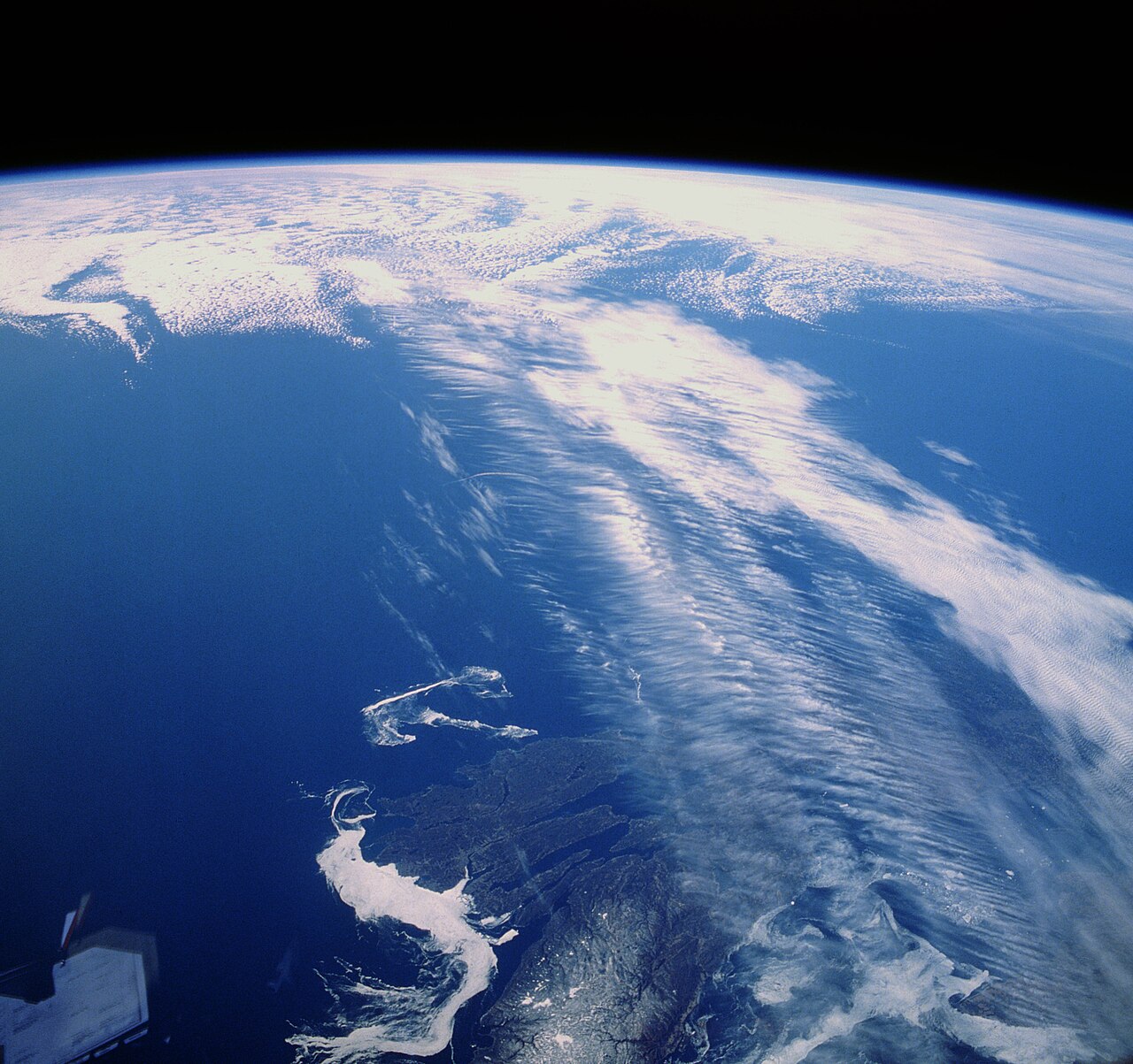
How do jet streams form? The process begins where strong horizontal temperature contrasts create a steep pressure gradient in the upper troposphere. Earth's rotation then turns that resulting air movement into narrow bands of fast westerly wind near the tropopause, forming powerful high-altitude currents that drive global weather systems.
Key takeaways
Dropping from 18 km over the tropics to just 8 km at the poles, tropopause height variation creates a sloping boundary that concentrates atmospheric flow.
The Coriolis effect deflects poleward-moving air into rapid, west-to-east flowing winds.
Two primary currents, the polar jet stream and the subtropical jet stream, dictate upper-level global troposphere wind patterns.
These narrow atmospheric bands actively steer mid-latitude storm tracks and influence the paths of tropical weather systems.
Fluctuations in planetary waves cause jet streams to meander widely, leading to downstream extreme weather events.
How do jet streams form?
How do jet streams form is best understood through the interaction of intense atmospheric temperature gradients and the Coriolis effect. As air moves from warmer tropical regions to colder polar regions, the Earth's rotation deflects this flow. This creates high-velocity, narrow bands of wind at the tropopause boundary where pressure differences are most extreme.
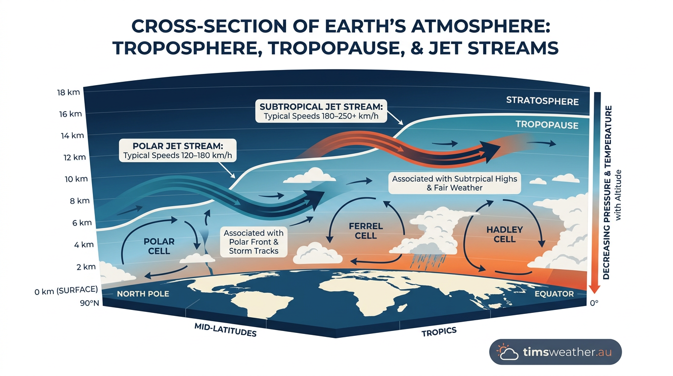
Global circulation cells and the tropopause boundary
The entire troposphere is capped by an invisible lid known as the tropopause. This boundary separates the active, weather-producing troposphere from the highly stable stratosphere above it. Jet streams are tightly bound to this boundary layer, locating themselves exactly where distinct atmospheric circulation cells collide.
Global atmospheric circulation is dominated by three main cells in each hemisphere: the Hadley cell near the equator, the Ferrel cell in the mid-latitudes, and the Polar cell at the high latitudes. The interaction between these massive circulation cells generates staggering velocities, making it clear why mapping these boundaries is essential for forecasting.
The Role of the Tropopause in Jet Stream Confinement
Because cold air is denser than warm air, the depth of the troposphere varies significantly by latitude. Over the tropics, intense surface heating causes the air to expand, pushing the tropopause up to altitudes near 18 kilometres. Over the frigid poles, the dense, cold air compresses the troposphere, dropping the tropopause to just 8 kilometres above the surface.
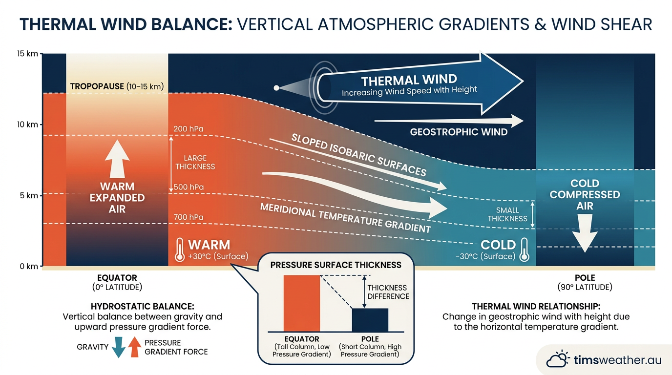
This stark difference in height creates a sloping roof across the planet. Jet streams naturally confine themselves into the distinct "breaks" or vertical steps in this sloping tropopause. The sudden shift in atmospheric depth at these breaks forces air to accelerate rapidly as it squeezes through a narrower vertical space.
When meteorologists study atmospheric dynamics, they look closely at these breaks. The sharp transition from the warm, expansive tropical air mass to the cooler, compressed mid-latitude air mass acts like a natural funnel, concentrating upper-level winds into a tight, high-speed corridor.
Hadley cell and Ferrel cell interactions
The subtropical jet stream forms near the poleward edge of the Hadley cell, not at the boundary where the descending branch of the Hadley cell meets the Ferrel cell. This convergence zone is typically positioned near 30 degrees latitude. Because the warm tropical troposphere expands to greater heights, the subtropical jet stream sits approximately 8 to 15 kilometres above the surface, often settling close to 12 kilometres (Geosciences LibreTexts).
Further north and south, the polar front jet stream forms where the temperate air of the Ferrel cell clashes violently with the freezing air of the Polar cell, generally between 50 and 60 degrees latitude. Due to the colder overall column of air, the tropopause sits much lower here, placing the polar jet stream closer to 10 kilometres in altitude.
Jet Stream Type | Typical Latitude | Driving Mechanism | Primary Meteorological Influence |
|---|---|---|---|
Subtropical Jet | ~30° North and South | Hadley and Ferrel cell convergence | Tropical moisture transport and cyclone recurvature |
Polar Front Jet | ~50° to 60° North and South | Ferrel and Polar cell boundary | Mid-latitude storm tracks and cold fronts |
The strength of the jet is directly proportional to the temperature difference across the cell boundary below it. Extreme observations show that upper-level wind speeds can occasionally exceed 300 km/h (186 mph) when differing air masses are pushed tightly together.
Thermal wind balance and the Coriolis effect
If Earth did not rotate, high-altitude winds would simply flow in a straight line from the equator to the poles. Instead, the physical forces of thermal wind balance and planetary rotation work together to create bands of continuous westerly wind.
Meteorologists and those with degrees in atmospheric science rely on complex thermodynamic equations to map these winds. The core principle driving the entire system is the horizontal temperature gradient, which translates directly into pressure variations high above the ground.
Pressure differences and horizontal temperature gradients
Air pressure decreases with altitude, but it decreases much faster in cold, dense air than in warm, expanded air. This physical law means that if you ascend to 10 kilometres above the cold poles, the pressure will be significantly lower than if you ascend to 10 kilometres above the warm equator.
This creates a massive pressure gradient high in the atmosphere, sloping directly from the equator toward the poles. Air naturally attempts to flow from high pressure to low pressure to equalize the imbalance. Because temperature differences drive this entire process, extreme solar heating at the equator and rapid cooling at the poles constantly fuel the pressure gradient (NewsOn6).
The term meridional temperature gradients describes this exact north-to-south variation in temperature. The steeper the gradient, the faster the resulting winds will blow. This is why jet streams reach their maximum intensity directly above the sharpest surface temperature boundaries, such as strong cold fronts or coastal margins in winter.
Polar Jet Stream Youtube Video Animation
Conservation of angular momentum and geostrophic wind
As the pressure gradient forces air to move poleward, the Coriolis effect, generated by Earth's constant rotation, fundamentally alters its path. The planet rotates beneath the moving air, forcing it to deflect to the right in the Northern Hemisphere and to the left in the Southern Hemisphere. By the time this air reaches the mid-latitudes, the deflection turns the poleward wind into a purely westerly flow.
This acceleration is further amplified by the conservation of angular momentum. Just as an ice skater spins faster when pulling their arms inward, air moving from the wide equator toward the narrower poles must increase its rotational speed to conserve momentum. This physical law forces the air to accelerate dramatically as it moves to higher latitudes (Cordulus).
The interaction between the pressure gradient force pushing the air poleward and the Coriolis force pushing it eastward creates a state known as geostrophic wind. When these two forces balance each other, the air flows parallel to the lines of equal pressure, creating a continuous planetary current.
Measuring the core structure of jet streams
Jet streams are not uniform tubes of air circling the globe. They are vast, flattened ribbon-like structures that constantly break apart, merge, and reform. Mapping them requires strict quantitative thresholds and continuous atmospheric sampling.
Forecasters use a combination of satellite-derived atmospheric motion vectors, radiosonde weather balloons, and commercial aircraft telemetry to map these dimensions in real time. When analyzing how do cold fronts form and propagate across a continent, meteorologists map the precise depth and width of the jet core aloft to determine exactly where the surface boundary will be pushed next.
WMO classifications and aviation thresholds
According to World Meteorological Organization aviation guidance, a jet stream is formally defined as a strong, narrow current in the upper troposphere or lower stratosphere, characterised by pronounced vertical and lateral wind shear. It must contain one or more distinct speed maxima along its axis to be classified as a true jet core.
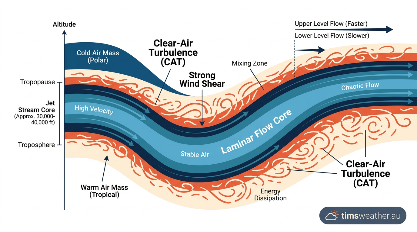
WMO and ICAO usage commonly treats 60 knots as a minimum core speed for a jet stream in aviation meteorology, although some aviation guidance uses 50 knots as a lower threshold for strong upper-level wind features. A typical jet core is usually a few hundred kilometres wide but only 1.5 to 3 kilometres deep, while its length can extend for thousands of kilometres around the hemisphere.
Meteorological video analysis frequently demonstrates how these powerful west-to-east prevailing winds traverse the globe at constant altitudes between 30,000 and 45,000 feet (Gavin Sandell). Because they span such immense distances, forecasting their exact core velocities remains a daily priority for international aviation authorities.
Transitioning from laminar to turbulent flow
Looking at this current through a fluid dynamics lens reveals complex behaviours. The absolute core of a jet stream often exhibits smooth, laminar flow, allowing air parcels to travel with minimal friction at maximum speed. This clean flow path is what commercial aircraft seek out when flying eastbound to reduce fuel consumption and flight times.
However, at the outer margins of this high-speed river, extreme vertical and lateral wind shear creates severe friction against the slower-moving ambient air. This sudden transition from laminar flow to turbulent flow generates intense clear-air turbulence, which cannot be detected by conventional aircraft weather radar.
Aviation routing depends heavily on mapping these specific currents. Fast-moving air bands located at altitudes of 9 to 16 kilometres significantly influence global logistics, while the turbulent boundaries pose serious safety hazards that aircraft must avoid entirely (The Watchers).
Planetary waves and seasonal jet stream meandering
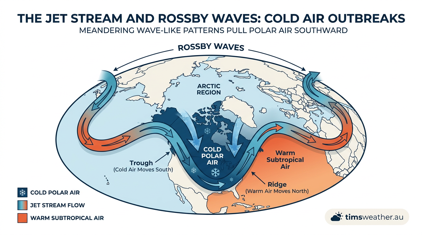
Jet streams rarely follow a perfect latitudinal circle around the globe. They constantly bend, dip, and buckle, creating massive northward ridges and southward troughs. This wild meandering alters weather conditions across entire continents.
Topographic barriers like the Himalayas or the Rocky Mountains force the jet stream off its standard zonal path. Combined with the contrasting heat capacities of massive oceans and landmasses, these physical barriers trigger immense undulations that propagate downstream.
Why Jet Streams Meander: The Physics of Rossby Waves
These massive atmospheric undulations are driven primarily by planetary waves. When you examine how do Rossby waves form, it becomes clear that these slow-moving wave patterns are the exact mechanism that transports tropical heat poleward and polar cold air equatorward. They act as the primary temperature regulation system for the planet.
As a Rossby wave deepens, the jet stream is forced into sharp curves. A deep southward dip, known as a trough, drags freezing polar air deep into the sub-tropics. Conversely, a northward curve, known as a ridge, pulls warm surface air toward the poles. This constant redistribution of heat prevents the equator from boiling and the poles from freezing solid.
The speed at which these planetary waves move west-to-east dictates how long specific weather patterns linger over one location. When the waves stall entirely, they create atmospheric blocking patterns. This exact mechanism explains how do heatwaves form over landmasses, trapping high-pressure systems in place for weeks at a time.
Seasonal Shifts: How Earth's Tilt Drives Jet Stream Migration
Seasonal shifts dramatically alter these wave patterns and the jet stream's overall behaviour. In winter, the equator-to-pole temperature gradient reaches its peak because the winter pole receives almost zero solar radiation. This massive temperature deficit intensifies the polar jet stream, causing it to shift closer to the equator while reaching its highest annual wind speeds.
Detailed spatio-temporal variability records confirm that this seasonal migration directly dictates the onset of winter weather patterns. A strong, equatorward-shifted jet stream locks cold air in place or releases it in sudden bursts across the Northern and Southern Hemispheres (PMC). How these shifts also helps explain how do blizzards form during deep mid-winter troughs.
During summer months, the temperature contrast weakens significantly as the poles warm up. This causes the jet streams to retreat poleward, weaken in intensity, and flow much more sluggishly. A weaker summer jet stream often leads to stagnant weather patterns and slow-moving thunderstorm complexes.
The Impact of Arctic Amplification on Jet Stream Stability
Modern climate research relies heavily on historical ERA5 reanalysis data from the European Centre for Medium-Range Weather Forecasts (ECMWF) to track long-term changes in these patterns. This data reveals that as the Arctic warms at a rate significantly faster than the rest of the globe, the overall temperature gradient between the equator and the North Pole is decreasing.
This phenomenon, known as Arctic amplification, directly impacts jet stream stability. A weaker temperature gradient results in a weaker, slower polar jet stream. Just as a slow-moving river meanders more widely than a fast-moving rapid, a weakened jet stream is prone to deeper, more pronounced Rossby waves.
These amplified waves tend to stall, leading to prolonged periods of extreme weather. Whether it is a devastating freeze reaching deep into subtropical latitudes or a blistering heat dome parked over a northern continent, a destabilised polar jet stream translates directly to persistent, highly disruptive surface conditions.
Steering influences on storm tracks and atmospheric rivers
The most important function of the jet stream for daily life is its role as a steering mechanism for major surface weather systems. The distinct structural variations between the polar and subtropical jets dictate very different weather outcomes globally.
Both streams interact with surface pressure systems dynamically. Upper-level atmospheric flow is the engine that generates, strengthens, and ultimately dissipates nearly every major storm on Earth.
Mid-latitude storm tracks and the polar jet stream
The polar front jet heavily influences mid-latitude weather conditions. As the jet stream meanders through its troughs and ridges, it creates upper-level areas of divergence, where air spreads out, and convergence, where air piles up. Upper-level divergence literally vacuums air out of the atmospheric column, forcing surface pressure to drop rapidly.
This physical evacuation of air aloft is exactly how do low-pressure systems form and subsequently intensify. The strongest mid-latitude cyclones, capable of producing hurricane-force wind gusts and massive snowfall totals, invariably form directly beneath the divergent quadrant of an intense polar jet streak.
Conversely, areas of upper-level convergence force air downward toward the surface. This sinking motion suppresses cloud development and increases surface pressure, which explains how do high-pressure systems form directly beneath the ridges of the polar jet. The constant interplay between these rising and sinking air masses creates the alternating fair weather and storm tracks typical of the mid-latitudes.
Subtropical jet stream influence on tropical weather
The subtropical jet stream serves a highly specialized role in moisture transport and tropical system disruption. Under the right thermodynamic conditions, a dip in the subtropical jet can tap directly into dense equatorial humidity. It pulls a narrow, highly concentrated corridor of water vapour poleward, acting as a high-speed conveyor belt known as an atmospheric river. These features can dump devastating rainfall totals when they strike mountainous coastal terrain.
The subtropical jet also dictates the life cycle of tropical storm systems. How how do tropical cyclones form requires evaluating sea surface temperatures and low wind shear, but determining where they will ultimately track requires monitoring the subtropical jet stream.
When a tropical cyclone interacts with a deep trough in the subtropical jet, the intense upper-level winds usually steer the system sharply away from the tropics, forcing recurvature. At the same time, the aggressive wind shear found at the jet stream's boundary often acts to tear the cyclone's convective core apart, forcing the system to transition into an extratropical low or dissipate entirely over colder waters.
Sources
NOAA weather and atmospheric science reference (dev-04-drupal-climate.woc.noaa.gov)
WMO e-Library (library.wmo.int)
Climate Prediction Center - ENSO (cpc.ncep.noaa.gov)
NOAA weather and atmospheric science reference (arl.noaa.gov)
NOAA weather and atmospheric science reference (csl.noaa.gov)
NOAA weather and atmospheric science reference (repository.library.noaa.gov)
CSIRO atmospheric science reference (publish.csiro.au)
NOAA weather and atmospheric science reference (repository.library.noaa.gov)
Last verified: 2026-09-15
Frequently asked questions
Jet streams form when strong temperature contrasts between air masses create sharp pressure differences high in the troposphere. The rotation of the Earth, known as the Coriolis effect, then bends this moving air into fast, west-to-east flowing currents, typically positioned near the tropopause where temperature gradients are at their most intense.
Source: earthobservatory.nasa.gov
Further reading and resources
Explore trusted articles, books, videos and other resources to go deeper on this topic.
youtube.comVideo
How jet streams affect our weather: an in-depth guide - YouTube
Video coverage on How do jet streams form? The complete meteorological guide from youtube.com.
skybrary.aeroArticle
Jet Stream | SKYbrary Aviation Safety
In-depth coverage on How do jet streams form? The complete meteorological guide from skybrary.aero.
climate.govReference
What is the jet stream? | NOAA Climate.gov
Background reference on How do jet streams form? The complete meteorological guide from climate.gov.
windy.appArticle
How jet streams work - Windy.app
In-depth coverage on How do jet streams form? The complete meteorological guide from windy.app.
eoas.ubc.caArticle
Jet Streams and Mid-latitude Systems - UBC EOAS
In-depth coverage on How do jet streams form? The complete meteorological guide from eoas.ubc.ca.
noaa.govReference
The Jet Stream | National Oceanic and Atmospheric Administration - NOAA
Background reference on How do jet streams form? The complete meteorological guide from noaa.gov.
nesdis.noaa.govReference
What Is the Jet Stream? | NESDIS - NOAA
Background reference on How do jet streams form? The complete meteorological guide from nesdis.noaa.gov.
en.wikipedia.orgReference
Jet stream - Wikipedia
Background reference on How do jet streams form? The complete meteorological guide from en.wikipedia.org.
user.eumetsat.intArticle
Jet streams - EUMETSAT - User Portal
In-depth coverage on How do jet streams form? The complete meteorological guide from user.eumetsat.int.
svs.gsfc.nasa.govReference
The Polar Jet Stream - NASA SVS
Background reference on How do jet streams form? The complete meteorological guide from svs.gsfc.nasa.gov.
Planning weeks ahead?
Check Australia's long-range seasonal outlook for rainfall, temperature and the climate drivers (ENSO, IOD, SAM, MJO) shaping the next three months.
View Australia's Seasonal Weather Forecast